Google Mars HiRISE base images for Opportunity |

  |
Google Mars HiRISE base images for Opportunity |
 Feb 8 2011, 11:34 PM Feb 8 2011, 11:34 PM
Post
#61
|
|
 Member  Group: Members Posts: 754 Joined: 9-February 07 Member No.: 1700 |
I've found my religion, and it is Google Mars, via Saints Emily and Eduardo! Thanks so much
|
 |
 
|
|
Feb 8 2011, 11:34 PM
Post
#62
|
|
 Administrator Group: Admin Posts: 5172 Joined: 4-August 05 From: Pasadena, CA, USA, Earth Member No.: 454 |
Don't forget to thank SFJCody -- he did the lion's share of the work getting earlier map updates done.
-------------------- My website - My Patreon - @elakdawalla on Twitter - Please support unmannedspaceflight.com by donating here.
|
|
|
|
|
Feb 9 2011, 12:31 AM
Post
#63
|
|
 Member Group: Members Posts: 399 Joined: 28-August 07 From: San Francisco Member No.: 3511 |
Thank you one and all for mapping,hosting and posting this... Just Awesome

-------------------- 'She drove until the wheels fell off...'
|
|
|
|
|
Feb 9 2011, 09:02 AM
Post
#64
|
|
|
Junior Member Group: Members Posts: 41 Joined: 18-September 09 Member No.: 4946 |
I am so pleased right now that words can't describe it! EXCELLENT WORK. I am also happy that you have it all covered on the first topic now!
You guys are the best, many thanks to all of you who have made this possible! |
|
|
|
|
Feb 9 2011, 11:30 AM
Post
#65
|
|
 Senior Member Group: Members Posts: 1089 Joined: 19-February 05 From: Close to Meudon Observatory in France Member No.: 172 |
QUOTE (brellis @ Feb 9 2011, 12:34 AM)  I've found my religion, and it is Google Mars, via Saints Emily and Eduardo! Thanks so much It reminds me a guy from Lehman Brothers early 2008 saying "My religion is the Stock Market"... 
|
|
|
|
|
Feb 24 2011, 09:14 PM
Post
#66
|
|
|
Member Group: Members Posts: 194 Joined: 3-January 10 Member No.: 5156 |
Also from me very much thanks for the maps: Let's set the sail to Cape York!
-------------------- Need more input ...
|
|
|
|
|
Apr 14 2011, 04:06 AM
Post
#67
|
|
|
Administrator Group: Admin Posts: 5172 Joined: 4-August 05 From: Pasadena, CA, USA, Earth Member No.: 454 |
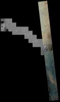
There's a lovely new color view of the northwest rim of Endeavour: http://www.uahirise.org/ESP_021892_1775
This makes me wonder what parts of Opportunity's path have been covered in color. It's a question I know I could answer myself if I had the time, but I don't. If I were going to answer it, I'd figure out which images crossed Opportunity's path and then identify the regions lacking color coverage..... -------------------- My website - My Patreon - @elakdawalla on Twitter - Please support unmannedspaceflight.com by donating here.
|
|
|
|
|
Apr 14 2011, 04:18 AM
Post
#68
|
|
 Senior Member Group: Admin Posts: 4763 Joined: 15-March 05 From: Glendale, AZ Member No.: 197 |

-------------------- If Occam had heard my theory, things would be very different now.
|
|
|
|
|
Apr 14 2011, 04:51 AM
Post
#69
|
|
|
Member Group: Members Posts: 399 Joined: 28-August 07 From: San Francisco Member No.: 3511 |
Thanks for posting that beautifully colored view...
I notice the related context swath was out-with Oppy's current travails... Is HiRISE planned to continue on Oppy's trek, by any routine ? Happy HiWISHES -------------------- 'She drove until the wheels fell off...'
|
|
|
|
|
Apr 14 2011, 08:02 AM
Post
#70
|
||
 Senior Member Group: Admin Posts: 3108 Joined: 21-December 05 From: Canberra, Australia Member No.: 615 |
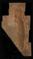
This is a start on the colour coverage with the latest images.
If anyone would like a larger version (17.7mb) |
|
|
|
|
|
|
Apr 14 2011, 05:14 PM
Post
#71
|
||
 The Poet Dude Group: Moderator Posts: 5551 Joined: 15-March 04 From: Kendal, Cumbria, UK Member No.: 60 |
Tweaked the new HiRISE image of Cape York to make it look a little less garish, hopefully a little more natural, and then, just for fun - so not claiming mega-accuracy - dropped some 'virtual Oppys' onto it at various places, to show the scale of the features at Cape York...
This might be useful for our lower-tech members who can't access HiRISE images via the IAS Viewer, or the Google Mars images. Edit: more pix at: http://roadtoendeavour.wordpress.com/2011/...ew-of-cape-york -------------------- |
|
|
|
|
|
|
Apr 14 2011, 05:36 PM
Post
#72
|
|
|
Senior Member Group: Members Posts: 2106 Joined: 13-February 10 From: Ontario Member No.: 5221 |
Oh wow!
Once we get on that color patch, that'd be as good a place as any to proclaim official 'arrival', right? For something this big, there's few well-defined borders.... |
|
|
|
|
Apr 15 2011, 05:23 AM
Post
#73
|
|
|
Member Group: Members Posts: 399 Joined: 28-August 07 From: San Francisco Member No.: 3511 |
Lovely view and I like those possible routes, Stu. Might the team forego those excursions in pursuit of the clays at Tribulation?
-------------------- 'She drove until the wheels fell off...'
|
|
|
|
|
May 19 2011, 10:30 PM
Post
#74
|
|
|
Junior Member Group: Members Posts: 36 Joined: 31-May 10 From: Poland Member No.: 5362 |
Lately I've been working on HiRISE GE extension of Endeavour rim, the area south of Cape York. As a result I uploaded this kmz example. The procedure was as follows:
1. cropped PSP_010341_1775_RED using JP2_PDS/PDS_JP2 ("Area" option) 2. converted JP2 to png using "convert" (ImageMagick) 3. loaded png to GE, tuned North, South etc. coordinates and finally saved as kmz Surely this method is not optimal. As a consequence I have one big image being loaded so GE hangs a little bit while loading. But later it works ok At the beginning I wanted to use MapTiler (just as it was done in previous posts) but it produced strange results for this big png file. My tests with smaller example files looked more optimistic with that program. Here are some screenshots:  http://www.flickr.com/photos/55907406@N08/...088526/sizes/m/ http://www.flickr.com/photos/55907406@N08/...088544/sizes/l/ http://www.flickr.com/photos/55907406@N08/...088528/sizes/l/ http://www.flickr.com/photos/55907406@N08/...088534/sizes/l/ (here it looks that I need to work more on that  ) )I decided to upload kmz maybe sbd would like to use it... https://rapidshare.com/files/1768082589/tes...deavour_rim.kmz -------------------- Polish space portal covering up-to-date space news: www.kosmonauta.net
|
|
|
|
|
May 20 2011, 06:08 AM
Post
#75
|
|
|
Senior Member Group: Moderator Posts: 4279 Joined: 19-April 05 From: .br at .es Member No.: 253 |
That sounds great!
But, as you said, it's not optimal given the file size; actually, my laptop almost freeze during 1-2 minutes and finally finishes with a big "X" (can't display) instead of the real picture. I'll suggest you to keep working with MapTiler but splitting the big source file into smaller (e.g. 8000x8000) pieces first. QUOTE (KrisK @ May 20 2011, 12:30 AM) At the beginning I wanted to use MapTiler (just as it was done in previous posts) but it produced strange results for this big png file. Could you detail it a little bit? QUOTE http://www.flickr.com/photos/55907406@N08/...088534/sizes/l/ (here it looks that I need to work more on that ) That's due to small differences in the lat/long coordinates you are using (in relation to the map I made). I can provide you with some data that should solve it, if you want. |
|
|
|
|

|
Lo-Fi Version | Time is now: 24th September 2024 - 07:38 AM |
|
RULES AND GUIDELINES Please read the Forum Rules and Guidelines before posting. IMAGE COPYRIGHT |
OPINIONS AND MODERATION Opinions expressed on UnmannedSpaceflight.com are those of the individual posters and do not necessarily reflect the opinions of UnmannedSpaceflight.com or The Planetary Society. The all-volunteer UnmannedSpaceflight.com moderation team is wholly independent of The Planetary Society. The Planetary Society has no influence over decisions made by the UnmannedSpaceflight.com moderators. |
SUPPORT THE FORUM Unmannedspaceflight.com is funded by the Planetary Society. Please consider supporting our work and many other projects by donating to the Society or becoming a member. |
|