Enceladus PDS image products |

Enceladus PDS image products |
 Jul 22 2010, 03:22 PM Jul 22 2010, 03:22 PM
Post
#1
|
|||
 IMG to PNG GOD  Group: Moderator Posts: 2254 Joined: 19-February 04 From: Near fire and ice Member No.: 38 |
Following discussions in the Image Processing Techniques subforum (see in particular this thread but also this one) I have now managed to create DEMs of acceptable quality of Enceladus using shape from shading and extensive post processing (mainly destriping). I now have a DEM mosaicked together from 5 images obtained during Cassini's first flyby of Enceladus in 2005. This will eventually become a global 23040x11520 pixel DEM but finishing it is going to be a lot of work (I will probably be using 50-100 images or more). Not all of Enceladus has been imaged at this resolution but there are many high resolution patches and I want a DEM big enough for these.
This 5 image DEM was big enough for me to really want to see what an Enceladus DEM animation would look like. So here we go:  enceladus_sfs_umsf.avi ( 7.74MB )
Number of downloads: 1309
enceladus_sfs_umsf.avi ( 7.74MB )
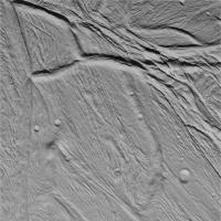
Number of downloads: 1309The field of view is 50 degrees. Most of the animation is at an altitude of 25-30 km. This is similar to Cassini's altitide during the closest flybys and the speed is not far from Cassini's speed either. However, the animation starts and ends at higher altitudes and we also swoop down to an altitude of ~10 km where the resolution of the DEM is highest. This is the Cassini image I used for the highest resolution part of the DEM:
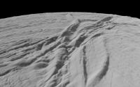
And a single frame from the animation showing a part of this terrain:
The DEM should be fairly accurate - in particular the animation should give a very good general idea of what Enceladus looks like even though some details are inaccurate. Also a higher resolution DEM is really needed for these low altitudes - the surface should look less smooth than it does here. Most of the striping is real though as there are lots of parallel ridges and grooves on Enceladus. There may be some spurious stripes but these are very subtle - the obvious ones are real. I'll do a new animation once I have a significantly bigger DEM. It will probably have better optimized illumination. Shadows are really needed in the first half of this one because I optimized the illumination for the highest resolution part of the DEM. We fly over that part of the DEM at roughly 00:30. EDIT: To play the animation you need to have an H.264 codec installed (if you are using Windows you can find one here for example). |
||
 |
 
|
||
 |
|
Jun 28 2011, 10:23 PM
Post
#16
|
|
 Senior Member Group: Moderator Posts: 3241 Joined: 11-February 04 From: Tucson, AZ Member No.: 23 |
Not bad, not bad at all. You did better at blending the high res frame in with the rest than I did:
http://www.ciclops.org/view/2456/Enceladus...ling_Hemisphere -------------------- &@^^!% Jim! I'm a geologist, not a physicist!
The Gish Bar Times - A Blog all about Jupiter's Moon Io |
|
|
|
|
Jul 1 2011, 04:09 PM
Post
#17
|
|
 Lord Of The Uranian Rings Group: Members Posts: 798 Joined: 18-July 05 From: Plymouth, UK Member No.: 437 |
That's top-drawer, Bjorn. Simply top-drawer.

-------------------- |
|
|
|
|
Jul 1 2011, 06:26 PM
Post
#18
|
|
 Member Group: Members Posts: 796 Joined: 27-February 08 From: Heart of Europe Member No.: 4057 |
Feast for the Eyes!

-------------------- |
|
|
|
|
Jul 2 2011, 03:05 AM
Post
#19
|
|
 Interplanetary Dumpster Diver Group: Admin Posts: 4404 Joined: 17-February 04 From: Powell, TN Member No.: 33 |
Wow...Bjorn, that is all I can say, wow. Great work!
-------------------- |
|
|
|
|
Jul 2 2011, 03:35 AM
Post
#20
|
|
 Senior Member Group: Admin Posts: 4763 Joined: 15-March 05 From: Glendale, AZ Member No.: 197 |
Bjorn knows more than a little bit about ice.
-------------------- If Occam had heard my theory, things would be very different now.
|
|
|
|
|
Jul 3 2011, 11:24 PM
Post
#21
|
|
|
IMG to PNG GOD Group: Moderator Posts: 2254 Joined: 19-February 04 From: Near fire and ice Member No.: 38 |
QUOTE (ElkGroveDan @ Jul 2 2011, 03:35 AM)  Bjorn knows more than a little bit about ice. Yes, a bit  . .Regarding Enceladus, more mosaics are coming in the next several weeks, possibly better than this one. And the DEM I now have of most of the terrain visible in the mosaic I posted turned out awesome - I even managed to confuse a rendered image with a Cassini image for a few seconds, the first time this has happened to me. Needless to say I was happy. BTW ISIS is turning out to be easier to use than I had expected. I used ISIS 2 a bit several years ago but ISIS 3 (which I'm using now) is considerably easier to use in my opinion. |
|
|
|
|
Jul 4 2011, 02:13 PM
Post
#22
|
|
 Administrator Group: Admin Posts: 5172 Joined: 4-August 05 From: Pasadena, CA, USA, Earth Member No.: 454 |
Are you using ISIS on a Mac or running Linux?
-------------------- My website - My Patreon - @elakdawalla on Twitter - Please support unmannedspaceflight.com by donating here.
|
|
|
|
|
Jul 4 2011, 02:17 PM
Post
#23
|
|
|
IMG to PNG GOD Group: Moderator Posts: 2254 Joined: 19-February 04 From: Near fire and ice Member No.: 38 |
QUOTE (elakdawalla @ Jul 4 2011, 02:13 PM) Are you using ISIS on a Mac or running Linux? Linux on a machine with a dual boot configuration (Windows 7 and Linux). |
|
|
|
|
Jul 4 2011, 02:21 PM
Post
#24
|
|
|
Founder Group: Chairman Posts: 14434 Joined: 8-February 04 Member No.: 1 |
On a Mac, apart from having to use the terminal to set some path variables before you use it - it's actually fairly easy. You can run it all from the terminal ( Mac version of a dos prompt ) or you can have actual programs for each app in turn.
|
|
|
|
|
Oct 5 2011, 05:26 PM
Post
#25
|
|
 Senior Member Group: Members Posts: 3648 Joined: 1-October 05 From: Croatia Member No.: 523 |
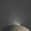
Calibrated NAC RGB view of Enceladus from Nov 30, 2010:
-------------------- |
|
|
|
|
Oct 5 2011, 06:53 PM
Post
#26
|
|
|
Member Group: Members Posts: 796 Joined: 27-February 08 From: Heart of Europe Member No.: 4057 |
Beautiful!
-------------------- |
|
|
|
|
Oct 5 2011, 09:01 PM
Post
#27
|
|
|
Solar System Cartographer Group: Members Posts: 10226 Joined: 5-April 05 From: Canada Member No.: 227 |
agreed!
Phil -------------------- ... because the Solar System ain't gonna map itself.
Also to be found posting similar content on https://mastodon.social/@PhilStooke Maps for download (free PDF: https://upload.wikimedia.org/wikipedia/comm...Cartography.pdf NOTE: everything created by me which I post on UMSF is considered to be in the public domain (NOT CC, public domain) |
|
|
|
|
Oct 5 2011, 10:23 PM
Post
#28
|
|
|
Senior Member Group: Members Posts: 3516 Joined: 4-November 05 From: North Wales Member No.: 542 |
An all time classic. That deserves wide circulation.
|
|
|
|
|
Oct 5 2011, 10:36 PM
Post
#29
|
|
|
Senior Member Group: Members Posts: 3648 Joined: 1-October 05 From: Croatia Member No.: 523 |
Thanks.
BTW, if that image looks slightly "foggy" to you, it's not an imaging artifact, it's the dense bulk of E ring around the moon revealing its presence. If Enceladus happened to split the ring optical density along Cassini's line of sight precisely in half, you would expect the background beyond Enceladus' dark limb to be twice as bright as the foreground. Here it's not quite that, but reasonably close. A rough measurement shows the foreground portion at about 60-ish percent brightness of the background. -------------------- |
|
|
|
|
Oct 5 2011, 11:21 PM
Post
#30
|
|
 The Poet Dude Group: Moderator Posts: 5551 Joined: 15-March 04 From: Kendal, Cumbria, UK Member No.: 60 |
Absolutely beautiful. Seriously, why your images aren't *everywhere* - in books and magazines, and on NASA's own websites - is a mystery to me.
-------------------- |
|
|
|
 |

|
Lo-Fi Version | Time is now: 22nd September 2024 - 10:15 PM |
|
RULES AND GUIDELINES Please read the Forum Rules and Guidelines before posting. IMAGE COPYRIGHT |
OPINIONS AND MODERATION Opinions expressed on UnmannedSpaceflight.com are those of the individual posters and do not necessarily reflect the opinions of UnmannedSpaceflight.com or The Planetary Society. The all-volunteer UnmannedSpaceflight.com moderation team is wholly independent of The Planetary Society. The Planetary Society has no influence over decisions made by the UnmannedSpaceflight.com moderators. |
SUPPORT THE FORUM Unmannedspaceflight.com is funded by the Planetary Society. Please consider supporting our work and many other projects by donating to the Society or becoming a member. |
|