Post Conjunction: Santa Maria to Cape York, The Journey to 'Spirit Point' |

  |
Post Conjunction: Santa Maria to Cape York, The Journey to 'Spirit Point' |
 Jul 12 2011, 03:34 PM Jul 12 2011, 03:34 PM
Post
#811
|
|
|
Member  Group: Members Posts: 140 Joined: 20-November 07 Member No.: 3967 |
QUOTE I'm going to just jump right ahead of everyone pointing out how hard Cape York is to see . . . Just a hunch, but I'm joining in with ElkGroveDan on this one. |
 |
 
|
|
Jul 12 2011, 03:42 PM
Post
#812
|
||
 Senior Member Group: Members Posts: 4247 Joined: 17-January 05 Member No.: 152 |
 I agree with Phil's diagram - thanks for making those, guys, I'm sure that helps a lot of people here. About Stu's new bump: here's an average of the L2/R2 frames, 3x Philovision:
My thinking is that new bump is just some subtle topography very close to Approach Crater, rather than farther away as Stu suggested. The ground past AC curves downwards (convex up), so I doubt we'd see any features farther away yet. If you scan the horizon away from AC, you can see more "bumps" and "dips" - that local horizon is now so close that little ripples could stick up like sore thumbs. |
|
|
|
|
|
|
Jul 12 2011, 04:58 PM
Post
#813
|
|
|
Solar System Cartographer Group: Members Posts: 10166 Joined: 5-April 05 From: Canada Member No.: 227 |
"little ripples could stick up like sore thumbs"
That's 'cause they are frantically texting 'look out, there's a rover heading straight for us!" Phil -------------------- ... because the Solar System ain't gonna map itself.
Also to be found posting similar content on https://mastodon.social/@PhilStooke Maps for download (free PD: https://upload.wikimedia.org/wikipedia/comm...Cartography.pdf NOTE: everything created by me which I post on UMSF is considered to be in the public domain (NOT CC, public domain) |
|
|
|
|
Jul 12 2011, 05:18 PM
Post
#814
|
|
|
Senior Member Group: Members Posts: 2921 Joined: 14-February 06 From: Very close to the Pyrénées Mountains (France) Member No.: 682 |
"sigh" I'm starting missing The Beacon "Sigh"
-------------------- |
|
|
|
|
Jul 12 2011, 06:11 PM
Post
#815
|
|
|
Member Group: Members Posts: 194 Joined: 3-January 10 Member No.: 5156 |
Maybe Cape York was just painted on the crater wall?

-------------------- Need more input ...
|
|
|
|
|
Jul 12 2011, 11:10 PM
Post
#816
|
|
|
Junior Member Group: Members Posts: 71 Joined: 19-January 10 From: Grimsby, N.E. Lincs, UK Member No.: 5179 |
Are we nearly there yet?
Neil  |
|
|
|
|
Jul 13 2011, 03:24 AM
Post
#817
|
|
 Senior Member Group: Members Posts: 2228 Joined: 1-December 04 From: Marble Falls, Texas, USA Member No.: 116 |
QUOTE (centsworth_II @ Jul 12 2011, 12:46 AM)  I really think the difference between calling Cape York a shelf on the wall of Endeavour and a low, exposed portion of Endeavour's rim is important. I think the latter is the case. ... Centworth_II: I wasn't trying to suggest that Cape York wasn't part of the Endeavour rim. It clearly is rim rock protruding through the Meridiani sediments. I was trying to use words to describe exactly the scenario that Phil posted. The sketch works better. -------------------- ...Tom
I'm not a Space Fan, I'm a Space Exploration Enthusiast. |
|
|
|
|
Jul 13 2011, 07:38 AM
Post
#818
|
|
|
Senior Member Group: Moderator Posts: 4279 Joined: 19-April 05 From: .br at .es Member No.: 253 |
Edited: 80m.
|
|
|
|
|
Jul 13 2011, 09:19 AM
Post
#819
|
||
|
Junior Member Group: Members Posts: 59 Joined: 18-July 07 From: London, UK Member No.: 2873 |
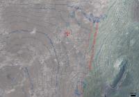
I make it about 500 m to my predicted visibility line (depending on the exact path taken), so only another 3 or 4 big drives. I'd probably guess the errors in my line placement are at least something like plus or minus 100 m, just to hedge my bets.
The dark blue contours in the image below are every 5 m, and the faint blue lines are every 1 m. The view of the dropoff into the crater at the same time as Cape York becomes visible should also be pretty nice. Either way, not long now! Pete
|
|
|
|
|
|
|
Jul 13 2011, 10:20 AM
Post
#820
|
||
|
Senior Member Group: Moderator Posts: 4279 Joined: 19-April 05 From: .br at .es Member No.: 253 |
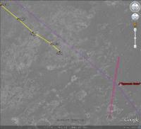
Sooo close now. I took a raw approximation of that visibility line (hope you don't mind) and plotted it on Google Mars together with the route till now.
|
|
|
|
|
|
|
Jul 13 2011, 11:22 AM
Post
#821
|
|
 Member Group: Members Posts: 813 Joined: 8-February 04 From: Arabia Terra Member No.: 12 |
Within spitting distance! Martian spitting distances are likely much longer than on Earth as the lower gravity and huge pressure differential between the air in your mouth/lungs and the atmosphere will aid in the transport of the saliva.
|
|
|
|
|
Jul 13 2011, 02:56 PM
Post
#822
|
|
|
Senior Member Group: Members Posts: 4247 Joined: 17-January 05 Member No.: 152 |
QUOTE (pgrindrod @ Jul 13 2011, 10:19 AM) The dark blue contours in the image below are every 5 m, and the faint blue lines are every 1 m. Thanks a lot for that, Pete. From that map, I estimate slopes into Endeavour of around 5 or 6 degrees in Botany Bay. The steepest parts of the inner/east side of CY are around 12 or 13 degrees. Those slopes are easily maneuverable by Oppy with six driving wheels.Of course this depends on whether there's an overall tilt to your map, but given the very small slopes your map gives out in the plains, any such tilt should be very small. Meanwhile, the horizon has dropped again after the sol 2654 drive: http://qt.exploratorium.edu/mars/opportuni...2M2.JPG?sol2654 The rate of drop should accelerate now... |
|
|
|
|
Jul 13 2011, 03:19 PM
Post
#823
|
|
|
Newbie Group: Members Posts: 14 Joined: 3-January 11 From: Pasadena, CA Member No.: 5592 |
QUOTE (ElkGroveDan @ Jul 12 2011, 06:45 AM) I'm going to just jump right ahead of everyone pointing out how hard Cape York is to see, and declare that we won't see Cape York until Opportunity is parked on its summit and extends the MI looking downward. Even then it will need to be a stack of 12 over-exposed images.. There. I should have been a Yorkshireman. Indeed -- CY is only a few meters high, if that. (Maybe somebody knows the resolution of the elevation maps out there?) -------------------- "There's no Launch Checklist Step 4a: 'Pause and reflect on the enormity of what happens next'."
|
|
|
|
|
Jul 13 2011, 03:20 PM
Post
#824
|
||
 The Poet Dude Group: Moderator Posts: 5551 Joined: 15-March 04 From: Kendal, Cumbria, UK Member No.: 60 |
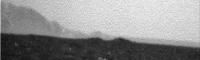
Stretch of new horizon view...
-------------------- |
|
|
|
|
|
|
Jul 13 2011, 03:31 PM
Post
#825
|
|
 Member Group: Members Posts: 550 Joined: 1-May 06 From: Scotland (Ecosse, Escocia) Member No.: 759 |
That's a lovely map, Pete.
The contours imply that we can reach a point with a view of Cape York by staying at the same altitude was we currently occupy, and driving south-east -- i.e. no need to cross another 1 metre contour. Don't forget that the height of the camera mast helps us to see it earlier. So it's basically a flat drive, with no more "up". It also shows, if accurate, that the summit of Cape York is about 11 metres lower than our current height. |
|
|
|
|

|
Lo-Fi Version | Time is now: 25th May 2024 - 09:34 PM |
|
RULES AND GUIDELINES Please read the Forum Rules and Guidelines before posting. IMAGE COPYRIGHT |
OPINIONS AND MODERATION Opinions expressed on UnmannedSpaceflight.com are those of the individual posters and do not necessarily reflect the opinions of UnmannedSpaceflight.com or The Planetary Society. The all-volunteer UnmannedSpaceflight.com moderation team is wholly independent of The Planetary Society. The Planetary Society has no influence over decisions made by the UnmannedSpaceflight.com moderators. |
SUPPORT THE FORUM Unmannedspaceflight.com is funded by the Planetary Society. Please consider supporting our work and many other projects by donating to the Society or becoming a member. |
|