Post Conjunction: Santa Maria to Cape York, The Journey to 'Spirit Point' |

  |
Post Conjunction: Santa Maria to Cape York, The Journey to 'Spirit Point' |
 Jul 21 2011, 02:32 AM Jul 21 2011, 02:32 AM
Post
#961
|
||
 Senior Member  Group: Members Posts: 4252 Joined: 17-January 05 Member No.: 152 |
Some west coast Canadians, too!
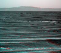
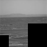
I love this navcam view: http://qt.exploratorium.edu/mars/opportuni...0M1.JPG?sol2661 Following the horizon from the right across to the far horizon on the left, you get a nice sense that we're starting to plunge into a huge crater! Here's a Philovision version to exagerate the effect:
I think we'll need another 100 metre drive (or two) before we'll start seeing CY... |
|
 |
 
|
|
|
Jul 21 2011, 02:33 AM
Post
#962
|
|
 Senior Member Group: Admin Posts: 4763 Joined: 15-March 05 From: Glendale, AZ Member No.: 197 |
QUOTE (Floyd @ Jul 20 2011, 06:54 PM)  Where are US west coast UMSFers???? Crikey, thanks mate. I had to mosey on down to the corral but it looks like I got back just in time for the hoedown. Stu will be getting up for work shortly and this will make his day. That's a really useful gif Astro0 amazing work in such a short time. -------------------- If Occam had heard my theory, things would be very different now.
|
|
|
|
|
Jul 21 2011, 02:35 AM
Post
#963
|
||
 Member Group: Members Posts: 404 Joined: 5-January 10 Member No.: 5161 |
In today's 3D the local sand field on the rim-top ends just within the range of perceptible 3D, and Endeavor's opposite side falls back from that, giving a sense of the opening void in store for us all!
|
|
|
|
|
|
|
Jul 21 2011, 03:30 AM
Post
#964
|
|
 Senior Member Group: Admin Posts: 3108 Joined: 21-December 05 From: Canberra, Australia Member No.: 615 |
That's an awesome anaglyph Walfy!
As we get closer to Endeavour, I was reminded of something someone said long ago  
|
|
|
|
|
Jul 21 2011, 04:45 AM
Post
#965
|
||
|
Senior Member Group: Members Posts: 4252 Joined: 17-January 05 Member No.: 152 |
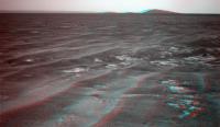
The lovely SE view in stereo:
The terrain's looking a bit bumpy in the foreground... |
|
|
|
|
|
|
Jul 21 2011, 05:19 AM
Post
#966
|
|||
 The Poet Dude Group: Moderator Posts: 5551 Joined: 15-March 04 From: Kendal, Cumbria, UK Member No.: 60 |
(yawn)
((stretch)) ...computer on... wanders over to kettle... grabs biccie from tin...sits down... logs on to UMSF... 
-------------------- |
||
|
|
|
||
|
Jul 21 2011, 06:43 AM
Post
#967
|
|
|
Senior Member Group: Moderator Posts: 4279 Joined: 19-April 05 From: .br at .es Member No.: 253 |
Hey Stu, I think "Approach Crater" now has an official name: Mariner9.
02662::p1973::03::6::0::0::6::0::12::navcam_mariner9_3x1_az_126_3_bpp |
|
|
|
|
Jul 21 2011, 07:33 AM
Post
#968
|
||
|
Senior Member Group: Moderator Posts: 4279 Joined: 19-April 05 From: .br at .es Member No.: 253 |
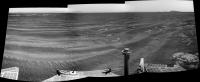
Here's yestersol navcam mosaic with Mariner9 / Approach Crater to the left.
|
|
|
|
|
|
|
Jul 21 2011, 01:37 PM
Post
#969
|
||
|
Solar System Cartographer Group: Members Posts: 10186 Joined: 5-April 05 From: Canada Member No.: 227 |
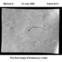
... and for comparison, here's the first image ever taken of Endeavour crater. Coming up to its anniversary!
Phil
(PS just finished text edits of the Mars book... but it stops at Mars Express. The next one will continue with MER) -------------------- ... because the Solar System ain't gonna map itself.
Also to be found posting similar content on https://mastodon.social/@PhilStooke Maps for download (free PD: https://upload.wikimedia.org/wikipedia/comm...Cartography.pdf NOTE: everything created by me which I post on UMSF is considered to be in the public domain (NOT CC, public domain) |
|
|
|
|
|
| Guest_Sunspot_* |
Jul 21 2011, 01:40 PM
Post
#970
|
|
Guests |
We have arrived at Mariner 9
|
|
|
|
|
Jul 21 2011, 01:51 PM
Post
#971
|
||
|
Senior Member Group: Moderator Posts: 4279 Joined: 19-April 05 From: .br at .es Member No.: 253 |
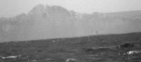
Today's batch of images include this one exposing another big crater on the far rim to the right of the one we already knew from a long time.
Original: http://qt.exploratorium.edu/mars/opportuni...T6P2367L2M2.JPG And, BTW, I'm pretty sure about seeing CY on one of the navcams; unfortunately is has been censored.  http://qt.exploratorium.edu/mars/opportuni...T6P1973L0M1.JPG |
|
|
|
|
|
|
Jul 21 2011, 01:58 PM
Post
#972
|
|||
|
Senior Member Group: Members Posts: 4252 Joined: 17-January 05 Member No.: 152 |
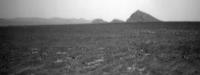
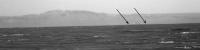
What's this?
3x Philovision:
After many false alarms, I'm hesitant to declare it CY, but this is the most promising target yet! |
||
|
|
|
||
|
Jul 21 2011, 02:04 PM
Post
#973
|
|
 Senior Member Group: Moderator Posts: 2262 Joined: 9-February 04 From: Melbourne - Oz Member No.: 16 |
Yeah I wouldn't want to say for sure but maybe, just maybe...
-------------------- |
|
|
|
|
Jul 21 2011, 02:17 PM
Post
#974
|
||
|
Junior Member Group: Members Posts: 59 Joined: 18-July 07 From: London, UK Member No.: 2873 |
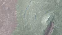
Let's see if I can get any more mileage out of my visibility map...
According to my reckoning Oppy should be just, and I mean just (~5 m) inside the visibility range of Cape York. As usual, green is visible from the summit of Cape York, red isn't.
So I think it's possible that Cape York has just started to rise up into view. Got to admit that the view is even more gobsmacking than I imagined. Brilliant stuff. Pete EDIT: should say, that red dot is Sol 2661 position |
|
|
|
|
|
|
Jul 21 2011, 02:22 PM
Post
#975
|
|
|
Solar System Cartographer Group: Members Posts: 10186 Joined: 5-April 05 From: Canada Member No.: 227 |
Could be! - GM says it's the right direction for the most prominent 'summit' of the Cape.
Phil -------------------- ... because the Solar System ain't gonna map itself.
Also to be found posting similar content on https://mastodon.social/@PhilStooke Maps for download (free PD: https://upload.wikimedia.org/wikipedia/comm...Cartography.pdf NOTE: everything created by me which I post on UMSF is considered to be in the public domain (NOT CC, public domain) |
|
|
|
|

|
Lo-Fi Version | Time is now: 6th June 2024 - 06:13 AM |
|
RULES AND GUIDELINES Please read the Forum Rules and Guidelines before posting. IMAGE COPYRIGHT |
OPINIONS AND MODERATION Opinions expressed on UnmannedSpaceflight.com are those of the individual posters and do not necessarily reflect the opinions of UnmannedSpaceflight.com or The Planetary Society. The all-volunteer UnmannedSpaceflight.com moderation team is wholly independent of The Planetary Society. The Planetary Society has no influence over decisions made by the UnmannedSpaceflight.com moderators. |
SUPPORT THE FORUM Unmannedspaceflight.com is funded by the Planetary Society. Please consider supporting our work and many other projects by donating to the Society or becoming a member. |
|