Dawn Survey Orbit Phase, First orbital phase |

  |
Dawn Survey Orbit Phase, First orbital phase |
 Jul 21 2011, 09:45 PM Jul 21 2011, 09:45 PM
Post
#76
|
|
|
Member  Group: Members Posts: 204 Joined: 29-June 05 Member No.: 421 |
another thing to question is the size of the error bars on the Hubble measurements of Vesta's size. The Thomas et al 1997 paper is online at http://www2.keck.hawaii.edu/inst/people/co...wg/icarus97.pdf. Skimming through that, they use images with a resolution of 52km per pixel. They estimate errors in the semi-major axes of +/- 5km, or 1/10 of a pixel. I don't know details of their fitting, but it doesnt seem crazy to me that they might have missed by a bigger fraction of a pixel than that. Getting sub-pixel info from images is hard.
|
 |
 
|
|
Jul 21 2011, 09:52 PM
Post
#77
|
|
 Administrator Group: Admin Posts: 5172 Joined: 4-August 05 From: Pasadena, CA, USA, Earth Member No.: 454 |
What surprised me about that paper was that their definitive reference for Vesta's size based on occultation data was from 1989. My 5 minutes of trawling in ADS didn't turn up anything obviously better. Given Vesta's huge size and interesting shape I'm surprised there haven't been more, better-quality occultation studies since then.
EDIT: Looking at fig 2 of that paper, I think it can be stated pretty strongly that no semi-axis of Vesta is at all likely to be longer than 290 km. -------------------- My website - My Patreon - @elakdawalla on Twitter - Please support unmannedspaceflight.com by donating here.
|
|
|
|
|
Jul 21 2011, 10:12 PM
Post
#78
|
|
 Senior Member Group: Moderator Posts: 2785 Joined: 10-November 06 From: Pasadena, CA Member No.: 1345 |
-------------------- Some higher resolution images available at my photostream: http://www.flickr.com/photos/31678681@N07/
|
|
|
|
|
Jul 21 2011, 10:17 PM
Post
#79
|
|
|
Administrator Group: Admin Posts: 5172 Joined: 4-August 05 From: Pasadena, CA, USA, Earth Member No.: 454 |
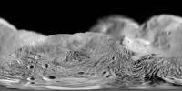
OK, now it looks like Hyperion. Vesta's an asteroid of many guises

-------------------- My website - My Patreon - @elakdawalla on Twitter - Please support unmannedspaceflight.com by donating here.
|
|
|
|
|
Jul 21 2011, 10:18 PM
Post
#80
|
|
 Senior Member Group: Members Posts: 3648 Joined: 1-October 05 From: Croatia Member No.: 523 |
So *that's* what it was reminding me of!
-------------------- |
|
|
|
|
Jul 21 2011, 10:21 PM
Post
#81
|
|
|
Member Group: Members Posts: 204 Joined: 29-June 05 Member No.: 421 |
QUOTE (elakdawalla @ Jul 21 2011, 04:52 PM)  Looking at fig 2 of that paper, I think it can be stated pretty strongly that no semi-axis of Vesta is at all likely to be longer than 290 km. I'm not so convinced. My understanding is those numbers are for best fit ellipses. But Vesta has a big chunk missing on one side. Fitting an ellipse to a shape which isn't an ellipse could give a systematic bias. The missing chunk would make all the best fit ellipses underestimate the true maximum dimension. |
|
|
|
|
Jul 21 2011, 10:23 PM
Post
#82
|
|
 Member Group: Members Posts: 723 Joined: 13-June 04 Member No.: 82 |
Has anybody looked at the effects of geometric perspective? Dawn is now close enough to Vesta that it should show a somewhat greater angular diameter as seen from Dawn than you would expect by simply dividing Vesta's diameter by its distance from Dawn. Vesta's edge, as seen by Dawn, is actually slightly closer to Dawn than the "great circle" perpendicular to the line connecting the centre of Vesta with Dawn, which would be slightly smaller as seen by Dawn (if it could be seen through solid rock). Therefore the number of pixels from one side of Vesta to the other would be slightly more than calculated using Vesta's diameter, and its distance from Dawn.
I do not know if the difference would be enough to account for the discrepancy described earlier, but somebody could check? |
|
|
|
|
Jul 21 2011, 10:53 PM
Post
#83
|
|
|
Junior Member Group: Members Posts: 73 Joined: 14-June 05 From: Cambridge, MA Member No.: 411 |
I have a question about Vesta's reference grid. A few days ago an image release specified as "The original image was map-projected, centered at 55 degrees southern latitude and 210 degrees eastern longitude." OK, the latitude is determined by Vesta's spin axis, of course, but how is the system of longitude determined? What feature on Vesta defines 0° (or some other standard) longitude?
|
|
|
|
|
Jul 21 2011, 11:37 PM
Post
#84
|
|
|
Administrator Group: Admin Posts: 5172 Joined: 4-August 05 From: Pasadena, CA, USA, Earth Member No.: 454 |
The answer to that question is in the paper that tfisher linked to: http://www2.keck.hawaii.edu/inst/people/co...wg/icarus97.pdf
QUOTE We propose a prime meridian centered on the most prominent visible feature. This is a nearly circular area, about 200 km across, with a lower albedo than its surroundings. Its origin is unknown at this time. Because it is the largest visible feature on Vesta, the name Olbers Regio has been proposed in honor of the asteroids discoverer; the name is not yet official. We have adjusted the longitude system to put 08 longitude at the center of this feature....
-------------------- My website - My Patreon - @elakdawalla on Twitter - Please support unmannedspaceflight.com by donating here.
|
|
|
|
|
Jul 22 2011, 12:43 AM
Post
#85
|
|
|
Junior Member Group: Members Posts: 73 Joined: 14-June 05 From: Cambridge, MA Member No.: 411 |
QUOTE (elakdawalla @ Jul 21 2011, 07:37 PM) The answer to that question is in the paper that tfisher linked to: http://www2.keck.hawaii.edu/inst/people/co...wg/icarus97.pdf Thanks, Emily ... |
|
|
|
|
Jul 22 2011, 01:49 AM
Post
#86
|
|
|
Senior Member Group: Members Posts: 1018 Joined: 29-November 05 From: Seattle, WA, USA Member No.: 590 |
QUOTE (Mongo @ Jul 21 2011, 03:23 PM) Dawn is now close enough to Vesta that it should show a somewhat greater angular diameter as seen from Dawn than you would expect by simply dividing Vesta's diameter by its distance from Dawn. Well, it's the difference between 2*r/d vs 2*arcsin(r/d), right? So if I take 10,500 km as the distance and 289 km as the radius, then I get an angular diameter of 3 degrees, 9 minutes, 16 seconds. As I figure it, your approximation is 2 seconds smaller. In survey orbit, at 2700 km, the difference will amount to about a minute and a half. (Someone should double check me, though.) --Greg |
|
|
|
|
Jul 22 2011, 03:44 AM
Post
#87
|
|
|
Member Group: Members Posts: 220 Joined: 13-October 05 Member No.: 528 |
I think we have a new image just posted at JPL website. Taken on July 18th.
Not sure how to embed a thumbnail, so I'll just have to put in a link. http://www.nasa.gov/mission_pages/dawn/mul...0721-image.html |
|
|
|
|
Jul 22 2011, 04:11 AM
Post
#88
|
|
|
Founder Group: Chairman Posts: 14434 Joined: 8-February 04 Member No.: 1 |
QUOTE (Mariner9 @ Jul 21 2011, 07:44 PM) I think we have a new image just posted at JPL website. Taken on July 18th. Already being discussed for a page of this thread - first cited here http://www.unmannedspaceflight.com/index.p...mp;#entry175945 |
|
|
|
|
Jul 22 2011, 07:16 AM
Post
#89
|
||
 Senior Member Group: Members Posts: 2492 Joined: 15-January 05 From: center Italy Member No.: 150 |
QUOTE (Greg Hullender @ Jul 20 2011, 02:13 PM) Another interesting stat might be energy/kilogram. Although kinetic energy is increasing, potential energy is decreasing. Nice idea, Greg; this is the output in terms of energy per mass unit (on the left), with a zoom around the insertion time:
On the right, a plot of ratio between the two energies vs distance (obviously, I considered absolute vaue of potential energy, which is increasing while approaching Vesta); target is a 2700 km distance with a 0.5 ratio (a circular survey orbit). -------------------- I always think before posting! - Marco -
|
|
|
|
|
|
|
Jul 22 2011, 02:09 PM
Post
#90
|
||
|
Solar System Cartographer Group: Members Posts: 10226 Joined: 5-April 05 From: Canada Member No.: 227 |
I have been playing with a very rough map of Vesta from the released images. Please bear in mind this is VERY approximate and not controlled by any shape model or pointing information. It is intended just to show approximate image coverage and locations of major features. The tie to more distant images is very rough. Zero longitude in the Hubble map/shape model coordinates would be at the left end (and the right, I guess). A much earlier version of this, posted here earlier, used a different (arbitrary) zero longitude.
Phil
-------------------- ... because the Solar System ain't gonna map itself.
Also to be found posting similar content on https://mastodon.social/@PhilStooke Maps for download (free PDF: https://upload.wikimedia.org/wikipedia/comm...Cartography.pdf NOTE: everything created by me which I post on UMSF is considered to be in the public domain (NOT CC, public domain) |
|
|
|
|
|
|

|
Lo-Fi Version | Time is now: 23rd September 2024 - 02:59 PM |
|
RULES AND GUIDELINES Please read the Forum Rules and Guidelines before posting. IMAGE COPYRIGHT |
OPINIONS AND MODERATION Opinions expressed on UnmannedSpaceflight.com are those of the individual posters and do not necessarily reflect the opinions of UnmannedSpaceflight.com or The Planetary Society. The all-volunteer UnmannedSpaceflight.com moderation team is wholly independent of The Planetary Society. The Planetary Society has no influence over decisions made by the UnmannedSpaceflight.com moderators. |
SUPPORT THE FORUM Unmannedspaceflight.com is funded by the Planetary Society. Please consider supporting our work and many other projects by donating to the Society or becoming a member. |
|