Post Conjunction: Santa Maria to Cape York, The Journey to 'Spirit Point' |

  |
Post Conjunction: Santa Maria to Cape York, The Journey to 'Spirit Point' |
 Jul 25 2011, 11:02 AM Jul 25 2011, 11:02 AM
Post
#1051
|
||
 Senior Member  Group: Admin Posts: 3108 Joined: 21-December 05 From: Canberra, Australia Member No.: 615 |
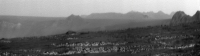
My-Oh-My! The scenery has certainly changed.

Note: A little sky added for effect 
|
|
 |
 
|
|
|
Jul 25 2011, 11:29 AM
Post
#1052
|
||
 Senior Member Group: Members Posts: 2492 Joined: 15-January 05 From: center Italy Member No.: 150 |
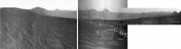
In this processed 5x vertical stretch of Ant103 pano, the distant mountains on the centre/right should be the Iazu rim... Can someone confirm?
Attached thumbnail(s)
-------------------- I always think before posting! - Marco -
|
|
|
|
|
|
|
Jul 25 2011, 11:51 AM
Post
#1053
|
|
 Senior Member Group: Moderator Posts: 2262 Joined: 9-February 04 From: Melbourne - Oz Member No.: 16 |
QUOTE (dilo @ Jul 25 2011, 12:29 PM)  Iazu rim... Can someone confirm? Confirmed. You can see the dark promontory that we've been able to see for years in the middle of it. -------------------- |
|
|
|
|
Jul 25 2011, 11:51 AM
Post
#1054
|
|
 Chief Assistant Group: Admin Posts: 1409 Joined: 5-January 05 From: Ierapetra, Greece Member No.: 136 |
There's a distinct feature which appears darker; I think that is part of Iazu's ejecta blanket, and beyond that yes, I'd be surprised if it's anything but the rim of the crater itself.
-------------------- photographer, space imagery enthusiast, proud father and partner, and geek.
http://500px.com/sacred-photons & |
|
|
|
|
Jul 25 2011, 01:33 PM
Post
#1055
|
|
 Senior Member Group: Members Posts: 1619 Joined: 12-February 06 From: Bergerac - FR Member No.: 678 |
Amazing Astro0
 My version of this very promising pan 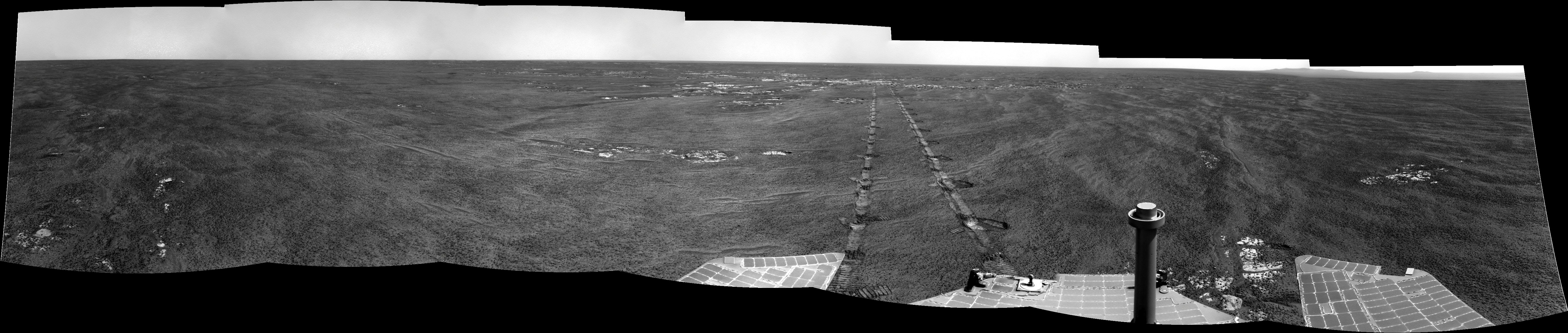 That will be EPIC ! -------------------- |
|
|
|
|
Jul 25 2011, 01:38 PM
Post
#1056
|
||
|
Solar System Cartographer Group: Members Posts: 10166 Joined: 5-April 05 From: Canada Member No.: 227 |
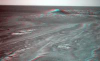
... and a combination of three of the recent postings showing a broad pan across Endeavour - resolution reduced to match the navcams in the middle. A full pancam view of this will be quite the eyecatcher.
Phil
-------------------- ... because the Solar System ain't gonna map itself.
Also to be found posting similar content on https://mastodon.social/@PhilStooke Maps for download (free PD: https://upload.wikimedia.org/wikipedia/comm...Cartography.pdf NOTE: everything created by me which I post on UMSF is considered to be in the public domain (NOT CC, public domain) |
|
|
|
|
|
|
Jul 25 2011, 02:58 PM
Post
#1057
|
||
 Senior Member Group: Members Posts: 4247 Joined: 17-January 05 Member No.: 152 |
Thanks for all the stunning pans, guys! Phil, that's the first view - Frankenstein monster or not! - that's given the impression of sitting on the edge of an immense crater - spectacular! And although the haziness of the far rim reduces the detail there, it adds to the sense of scale, making it pretty clear that the far rim is many km away...
Turning away from the view to the east for a moment, we had a beautiful view of
Quite a change from those two minute bumps on the horizon from a couple of months ago, eh? |
|
|
|
|
|
|
Jul 25 2011, 03:24 PM
Post
#1058
|
|
|
Solar System Cartographer Group: Members Posts: 10166 Joined: 5-April 05 From: Canada Member No.: 227 |
Mariner 9!
Phil -------------------- ... because the Solar System ain't gonna map itself.
Also to be found posting similar content on https://mastodon.social/@PhilStooke Maps for download (free PD: https://upload.wikimedia.org/wikipedia/comm...Cartography.pdf NOTE: everything created by me which I post on UMSF is considered to be in the public domain (NOT CC, public domain) |
|
|
|
|
Jul 25 2011, 04:01 PM
Post
#1059
|
|
 Member Group: Members Posts: 198 Joined: 2-March 05 From: Richmond, VA USA Member No.: 181 |
Phil, thank you for that pan. That really helped to convert the orbital FOV of Endeavour into a coherent surface viewscape -- a true 'sense of place' if that makes sense. The view is absolutely stunning!
-- Pertinax |
|
|
|
|
Jul 25 2011, 04:48 PM
Post
#1060
|
|
|
Member Group: Members Posts: 713 Joined: 30-March 05 Member No.: 223 |
QUOTE (ustrax @ Jul 24 2011, 11:04 PM) u-n-b-e-l-ie-v-a-b-l-e... I second that, Ustrax ! ... what a journey. .. this keeps just gettig better and better. |
|
|
|
|
Jul 25 2011, 06:53 PM
Post
#1061
|
|
|
Member Group: Members Posts: 813 Joined: 29-December 05 From: NE Oh, USA Member No.: 627 |
Wow....
I love the different horizon lines in the latest pans.. can see the lip of dip that Opportunity strolled out of .... What a trek Oppy is making... and thanks to MER team for releasing all the images and thanks UMSF folks for the wonderful use you make of these. Craig |
|
|
|
|
Jul 25 2011, 08:05 PM
Post
#1062
|
||
 The Poet Dude Group: Moderator Posts: 5551 Joined: 15-March 04 From: Kendal, Cumbria, UK Member No.: 60 |
Oh my...
We're almost there... almost there...
-------------------- |
|
|
|
|
|
|
Jul 25 2011, 08:10 PM
Post
#1063
|
|
|
Senior Member Group: Moderator Posts: 2262 Joined: 9-February 04 From: Melbourne - Oz Member No.: 16 |
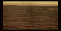
My version

-------------------- |
|
|
|
|
Jul 25 2011, 08:20 PM
Post
#1064
|
||
|
Senior Member Group: Members Posts: 4247 Joined: 17-January 05 Member No.: 152 |
Thanks, guys! We should point out that the high point of CY is on the left side near horizon in that new pan (as Deimos mentioned).
The new pancam view of Mariner 9 is amazing - here's an anaglyph:
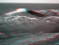
Do any of the geologically-minded care to speculate on what the light-toned material at the top of the highest point on the rim is? It looks pretty smooth for bedrock. It can't just be lighting, since there are other surfaces with similar tilt. Light-toned soil/dust? Does anyone recall seeing similar features before? |
|
|
|
|
|
|
Jul 25 2011, 08:23 PM
Post
#1065
|
||
|
The Poet Dude Group: Moderator Posts: 5551 Joined: 15-March 04 From: Kendal, Cumbria, UK Member No.: 60 |
Stretched crop...
-------------------- |
|
|
|
|
|
|

|
Lo-Fi Version | Time is now: 25th May 2024 - 12:15 PM |
|
RULES AND GUIDELINES Please read the Forum Rules and Guidelines before posting. IMAGE COPYRIGHT |
OPINIONS AND MODERATION Opinions expressed on UnmannedSpaceflight.com are those of the individual posters and do not necessarily reflect the opinions of UnmannedSpaceflight.com or The Planetary Society. The all-volunteer UnmannedSpaceflight.com moderation team is wholly independent of The Planetary Society. The Planetary Society has no influence over decisions made by the UnmannedSpaceflight.com moderators. |
SUPPORT THE FORUM Unmannedspaceflight.com is funded by the Planetary Society. Please consider supporting our work and many other projects by donating to the Society or becoming a member. |
|