Cape York - Shoemaker Ridge and the NE traverse, Starting sol 2735 |

  |
Cape York - Shoemaker Ridge and the NE traverse, Starting sol 2735 |
 Oct 12 2011, 12:27 PM Oct 12 2011, 12:27 PM
Post
#91
|
||
|
Senior Member  Group: Members Posts: 2998 Joined: 30-October 04 Member No.: 105 |
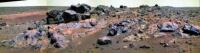
QUOTE (CR) I love this outcrop Indeed-- there is so much happening here. --Bill
Attached thumbnail(s)
-------------------- |
|
 |
 
|
|
|
Oct 12 2011, 01:29 PM
Post
#92
|
|||
 The Poet Dude Group: Moderator Posts: 5551 Joined: 15-March 04 From: Kendal, Cumbria, UK Member No.: 60 |
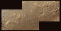
Just for fun - but scale is correct - a couple of simulated HiRISE views of what Oppy would look like if she continued to head north, stopping at some scenic points along the way...
-------------------- |
||
|
|
|
||
|
Oct 12 2011, 02:25 PM
Post
#93
|
|
 Senior Member Group: Members Posts: 4250 Joined: 17-January 05 Member No.: 152 |
Nice post about the current mapping strategy at Lenda's blog.
Also some new maps, which split Shoemaker ridge into "A" and "B" (we're currently near B ). |
|
|
|
|
Oct 12 2011, 02:45 PM
Post
#94
|
|
|
Senior Member Group: Members Posts: 2998 Joined: 30-October 04 Member No.: 105 |
Neat. Does anyone know a public source for the topo map in Matt Lenda's late blog entry?
http://1.bp.blogspot.com/-F_1LEola0VQ/TpUK...labels_2742.png 'Twould be nice to be able to snag those from time to time... --Bill -------------------- |
|
|
|
|
Oct 13 2011, 12:27 AM
Post
#95
|
||
|
Junior Member Group: Members Posts: 54 Joined: 10-August 11 Member No.: 6119 |
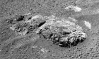
Small outcrop on Shoemaker Ridge 'B'
Navcam flicker gif, sol 2742.
|
|
|
|
|
|
|
Oct 13 2011, 05:48 AM
Post
#96
|
|
 Senior Member Group: Members Posts: 2228 Joined: 1-December 04 From: Marble Falls, Texas, USA Member No.: 116 |
QUOTE (Bill Harris @ Oct 12 2011, 08:45 AM)  Neat. Does anyone know a public source for the topo map in Matt Lenda's late blog entry?... Bill: I, too would like to find a source for that topo. We sometimes see some versions of that map at the Where are the Rovers now link at the JPL rover site. The OSU site is not very helpful in this regard.-------------------- ...Tom
I'm not a Space Fan, I'm a Space Exploration Enthusiast. |
|
|
|
|
Oct 13 2011, 06:07 AM
Post
#97
|
|
|
Senior Member Group: Members Posts: 2228 Joined: 1-December 04 From: Marble Falls, Texas, USA Member No.: 116 |
QUOTE Here context image! Take it! You'll need it! Matt: If you are going to post an image supporting a discussion about the need to find north facing slopes, you should either put a north arrow on your map, or you should follow the convention of making maps which have north at the top. Just a suggestion to make it easier for the rest us us to follow your line of reasoning. 
-------------------- ...Tom
I'm not a Space Fan, I'm a Space Exploration Enthusiast. |
|
|
|
|
Oct 13 2011, 10:28 AM
Post
#98
|
|
|
Senior Member Group: Members Posts: 2998 Joined: 30-October 04 Member No.: 105 |
I wasn't able to find an "OSU" on the Web. The entity OSU is apparently a loose university consortium of photogrammetric genuises and GIS geeks and not a physical brick-and-mortar organization with a receptionist and front office. I suspect that they develop maps and charts on an as-needed contract basis.
But this is standard photogrammetric work, developing topo maps from stereo pairs. The hard part is making the grid of elevations from the aerials, but this work is done with the contours provided on the map. I'm retired but can probably call in favors on powerful gridding software-- once the elevations and map control points are entered into an autocad-like file it would be trivial to generate one's own topo maps. This can be a lot of work, but do-able as a hobby and I may try it for grins and giggles some day. Thanks to Matt for sharing this with us, and I surely wish we had a similar topo map of the adjacent area to the NE...  --Bill -------------------- |
|
|
|
|
Oct 13 2011, 10:46 AM
Post
#99
|
|
|
Solar System Cartographer Group: Members Posts: 10182 Joined: 5-April 05 From: Canada Member No.: 227 |
OSU - Ohio State University, where Dr. Ron Li and his group have been involved in rover location finding and mapping since the start of the mission!
Phil http://shoreline.eng.ohio-state.edu/ron/_private/cv.html -------------------- ... because the Solar System ain't gonna map itself.
Also to be found posting similar content on https://mastodon.social/@PhilStooke Maps for download (free PD: https://upload.wikimedia.org/wikipedia/comm...Cartography.pdf NOTE: everything created by me which I post on UMSF is considered to be in the public domain (NOT CC, public domain) |
|
|
|
|
Oct 13 2011, 11:05 AM
Post
#100
|
|
|
Senior Member Group: Members Posts: 2998 Joined: 30-October 04 Member No.: 105 |
Yes, I saw Li's CV and know what OSU is and later found http://shoreline.eng.ohio-state.edu/ and even found this:
http://shoreline.eng.ohio-state.edu/album/...03/opp_2710.jpg --Bill -------------------- |
|
|
|
|
Oct 13 2011, 07:48 PM
Post
#101
|
|
|
Senior Member Group: Members Posts: 4250 Joined: 17-January 05 Member No.: 152 |
It looks like we're continuing our slope survey with another good drive NE on 2744. Although judging from this hazcam:
http://qt.exploratorium.edu/mars/opportuni...0M1.JPG?sol2744 you could be forgiven for thinking we've been transported back to the smooth terrain around Victoria! 
|
|
|
|
|
Oct 13 2011, 08:04 PM
Post
#102
|
|
|
Senior Member Group: Moderator Posts: 4279 Joined: 19-April 05 From: .br at .es Member No.: 253 |
63m NNE, actually.
And, well, I think this navcam gives the same impression too: http://qt.exploratorium.edu/mars/opportuni...JMP0613L0M1.JPG |
|
|
|
|
Oct 14 2011, 12:58 AM
Post
#103
|
|||
|
The Poet Dude Group: Moderator Posts: 5551 Joined: 15-March 04 From: Kendal, Cumbria, UK Member No.: 60 |
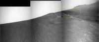
Interesting feature coming into view for Oppy now...
And stretched...
At first I thought that might be the more northerly parts of CY, but looking at Google Mars I'm now wondering if that dark tongue of material is actually darker ground sloping into Endeavour on the northern side of Artemis Crater..? -------------------- |
||
|
|
|
||
|
Oct 14 2011, 01:09 AM
Post
#104
|
|
|
Senior Member Group: Members Posts: 2998 Joined: 30-October 04 Member No.: 105 |
I'm thinking (tentatively, I've been turned around a lot lately) that the line of dark rocks in the upper right of this Navcam marks the near rim of the "summit crater" and that crater extends off to the left.
Sol-2744 Navcam: http://qt.exploratorium.edu/mars/opportuni...JMP0613L0M1.JPG That being the case, we are in the middle of the CRISM clay area. The soil at our wheels is quite different and remarkable, as seen in the Pan-, Nav- and Hazcams. T'would be a perfect opportunity for a "systematic foreground" image... --Bill -------------------- |
|
|
|
|
Oct 14 2011, 03:02 AM
Post
#105
|
||
|
Junior Member Group: Members Posts: 54 Joined: 10-August 11 Member No.: 6119 |
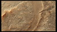
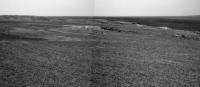
Sol 2744 right pancam stitch.
I assume this is the summit crater and the area to the east of it.
|
|
|
|
|
|
|

|
Lo-Fi Version | Time is now: 3rd June 2024 - 10:04 PM |
|
RULES AND GUIDELINES Please read the Forum Rules and Guidelines before posting. IMAGE COPYRIGHT |
OPINIONS AND MODERATION Opinions expressed on UnmannedSpaceflight.com are those of the individual posters and do not necessarily reflect the opinions of UnmannedSpaceflight.com or The Planetary Society. The all-volunteer UnmannedSpaceflight.com moderation team is wholly independent of The Planetary Society. The Planetary Society has no influence over decisions made by the UnmannedSpaceflight.com moderators. |
SUPPORT THE FORUM Unmannedspaceflight.com is funded by the Planetary Society. Please consider supporting our work and many other projects by donating to the Society or becoming a member. |
|