Venus Map with Feature Names |

  |
Venus Map with Feature Names |
 Feb 25 2012, 08:26 PM Feb 25 2012, 08:26 PM
Post
#1
|
||
 Senior Member  Group: Members Posts: 1669 Joined: 5-March 05 From: Boulder, CO Member No.: 184 |
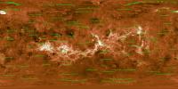
Here is a map of Venus I had put together (recall this collaboration with Emily L. and Calvin Hamilton), with the feature names now added.
Full Resolution: http://laps.noaa.gov/albers/sos/features/c..._180_center.png That's the latest, Steve -------------------- Steve [ my home page and planetary maps page ]
|
|
 |
 
|
|
|
Feb 25 2012, 08:41 PM
Post
#2
|
||
|
Senior Member Group: Members Posts: 1669 Joined: 5-March 05 From: Boulder, CO Member No.: 184 |
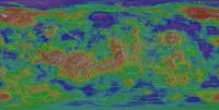
Using a shaded relief map we get another view. Might be better with a different feature color though:
Full Resolution: http://laps.noaa.gov/albers/sos/features/c..._180_center.png Steve -------------------- Steve [ my home page and planetary maps page ]
|
|
|
|
|
|
|
Feb 26 2012, 12:41 AM
Post
#3
|
|
|
Member Group: Members Posts: 890 Joined: 18-November 08 Member No.: 4489 |
if you are interested i have a 13.4 Gig C1 destriped and inpainted map i am almost done with
169000x84500 map |
|
|
|
|
Feb 26 2012, 04:05 PM
Post
#4
|
|
|
Senior Member Group: Members Posts: 1669 Joined: 5-March 05 From: Boulder, CO Member No.: 184 |
Yes, that would be nice to take a look at your higher resolution map. I recall that the data Emily had given me was intrinsically at a higher resolution than what I have used so far.
The features at present are plotted only if larger than 750-1500km, depending on feature type. These thresholds can be experimented with if one wants more names of smaller features. I also posted a transparent PNG file, so the feature overlay can be added to any map: http://laps.noaa.gov/albers/sos/features/overlay -------------------- Steve [ my home page and planetary maps page ]
|
|
|
|
|
Feb 27 2012, 05:51 AM
Post
#5
|
|
|
Member Group: Members Posts: 890 Joined: 18-November 08 Member No.: 4489 |
here is a link to a 16384x8192 pgm
82.0 MB (86031088 bytes) -- yes there is advertising -- http://www.zshare.net/download/9916352888d55b30/ it is a reduced down to 45.51 ppd from the 469.4485 ppd of the C1 |
|
|
|
|
Feb 28 2012, 12:01 AM
Post
#6
|
|
|
Member Group: Members Posts: 890 Joined: 18-November 08 Member No.: 4489 |
if you can not get to the 16 k map
some idiot did a DMCA clam that it was there file it was removed o grounds that some random person ( or bot) sent a DMCA if needed i can upload a new copy |
|
|
|
|
Mar 15 2013, 12:16 PM
Post
#7
|
|
 Member Group: Members Posts: 796 Joined: 27-February 08 From: Heart of Europe Member No.: 4057 |
I just finished my biggest work ever - topographic map of Venus.
Basic map description is directly in the map. For now, it's available only in reduced (50% of original size) and splitted jpg versions (61% and 80% of original size), mainly due to Picassa size limitations. If someone wants full PDF version of the map (~100 MB), send me a message (via UMSF message system or email). I will be glad for any constructive criticism and informations about errors. 
-------------------- |
|
|
|
|
Mar 15 2013, 02:47 PM
Post
#8
|
|
 Senior Member Group: Admin Posts: 4763 Joined: 15-March 05 From: Glendale, AZ Member No.: 197 |
Amazing!
(now Google Earth can add another planet) -------------------- If Occam had heard my theory, things would be very different now.
|
|
|
|
|
Mar 15 2013, 03:23 PM
Post
#9
|
|
|
Merciless Robot Group: Admin Posts: 8785 Joined: 8-December 05 From: Los Angeles Member No.: 602 |
Stunning, Daniel!

-------------------- A few will take this knowledge and use this power of a dream realized as a force for change, an impetus for further discovery to make less ancient dreams real.
|
|
|
|
|
Mar 15 2013, 03:50 PM
Post
#10
|
|
|
Solar System Cartographer Group: Members Posts: 10226 Joined: 5-April 05 From: Canada Member No.: 227 |
Yes, that is superb.
Phil -------------------- ... because the Solar System ain't gonna map itself.
Also to be found posting similar content on https://mastodon.social/@PhilStooke Maps for download (free PDF: https://upload.wikimedia.org/wikipedia/comm...Cartography.pdf NOTE: everything created by me which I post on UMSF is considered to be in the public domain (NOT CC, public domain) |
|
|
|
|
Mar 15 2013, 05:52 PM
Post
#11
|
|
 Interplanetary Dumpster Diver Group: Admin Posts: 4404 Joined: 17-February 04 From: Powell, TN Member No.: 33 |
Wow. Just wow. Amazing!
-------------------- |
|
|
|
|
Mar 15 2013, 08:13 PM
Post
#12
|
|
|
Member Group: Members Posts: 890 Joined: 18-November 08 Member No.: 4489 |
machi
what did you use as the base imaging data the c3 compressed data it looks like you also removes the ~+7 degree offset vertical stripping i had fun with that using the c1 data ,as you get closer to the poles the angle gets closer to +- 90 deg. google translated the blog and answered the question |
|
|
|
|
Mar 16 2013, 03:31 PM
Post
#13
|
|
|
Member Group: Members Posts: 796 Joined: 27-February 08 From: Heart of Europe Member No.: 4057 |
Dan, Nick, Phil, Ted
Thanks! John: I used left-, right-, and stereo-look maps from Map-a-Planet. It was hard task for this application, because it lasted 5 - 10 days for the M-a-P to complete these maps. In near future I want to look on other datasets and fill some gaps. Some data I have already on disk and it looks promisingly. -------------------- |
|
|
|
|
Mar 16 2013, 05:44 PM
Post
#14
|
|
|
Member Group: Members Posts: 890 Joined: 18-November 08 Member No.: 4489 |
there is a lot of missing data
the low resolution height data is missing a lot near the poles http://pds-geosciences.wustl.edu/mgn/mgn-v...1/mg_3002/gtdr/ and the "f" and "c1,c2,c3" reduced size data from the -- the c1 i used http://pds-imaging.jpl.nasa.gov/data/mgn-v...5-midr-c1-v1.0/ with the pole archive http://pds-imaging.jpl.nasa.gov/data/mgn-v...r-v1.0/mg_0127/ but i am also using ISIS3 for that data as for the "gaps" i had it "inpaint" them most of the missing data is near the poles so in a top down "polarstereographic" i used "resynthesizer" mostly to fill in the areas a bit of code i have been using for years , since before it became a gimp plugin . a screen shot of the southpole ( aprox -45 to -90 ) -- -180/180 is in the bottom middle 
|
|
|
|
|
Mar 17 2013, 10:39 AM
Post
#15
|
|
|
Member Group: Members Posts: 796 Joined: 27-February 08 From: Heart of Europe Member No.: 4057 |
"there is a lot of missing data"
Yes, some gaps cannot be filled with real data (topography, BTW I worked with MG_3003, MG_3002 is obsolete) and in some cases it's possible. I found dataset mg_0127 after I have all maps done, so this data will be incorporated in next version. Also this version has polar stereographic projections made with G.Projector, very good program, but limited in resolution (max. output 7500×3750). For next version I want to use higher resolution data resampled to native map resolution. It looks better. And I don't want to fill bigger gaps for which real data doesn't exists simply because this map must display our current coverage of the surface of Venus. But thank you for your info about "resynthesizer", I didn't know that. -------------------- |
|
|
|
|

|
Lo-Fi Version | Time is now: 23rd September 2024 - 06:29 PM |
|
RULES AND GUIDELINES Please read the Forum Rules and Guidelines before posting. IMAGE COPYRIGHT |
OPINIONS AND MODERATION Opinions expressed on UnmannedSpaceflight.com are those of the individual posters and do not necessarily reflect the opinions of UnmannedSpaceflight.com or The Planetary Society. The all-volunteer UnmannedSpaceflight.com moderation team is wholly independent of The Planetary Society. The Planetary Society has no influence over decisions made by the UnmannedSpaceflight.com moderators. |
SUPPORT THE FORUM Unmannedspaceflight.com is funded by the Planetary Society. Please consider supporting our work and many other projects by donating to the Society or becoming a member. |
|