MSL Post Landing - Commissioning Period & Early Observations, Commissioning Activity Period 1B - Sols 9 through 16 |

  |
MSL Post Landing - Commissioning Period & Early Observations, Commissioning Activity Period 1B - Sols 9 through 16 |
 Aug 18 2012, 07:56 AM Aug 18 2012, 07:56 AM
Post
#46
|
|
|
Member  Group: Members Posts: 282 Joined: 18-June 04 Member No.: 84 |
QUOTE (djellison @ Aug 18 2012, 12:26 AM)  Yeah- there are some serious flight rules about sun-pointing the mast. Im trying to imagine sunrise with Mastcam100 
|
 |
 
|
|
Aug 18 2012, 10:59 AM
Post
#47
|
|
 The Poet Dude Group: Moderator Posts: 5551 Joined: 15-March 04 From: Kendal, Cumbria, UK Member No.: 60 |
QUOTE (fredk @ Aug 17 2012, 10:59 PM) We'll actually have to wait a very long time to see the absolute summit. From here we can only see the northern part of the central mound. I'm not sure we'll ever see it. I hope I'm wrong, but looking at it with Google Mars, I rather think that the actual summit will always be hidden from Curiosity's view by the lie of the land. Once she starts her ascent of Mt Sharp, heading for the light toned unit, the peak will be over the top of what she can see. So we might never get to see Mt Sharp as a mountain. -------------------- |
|
|
|
|
Aug 18 2012, 11:16 AM
Post
#48
|
|
|
Member Group: Members Posts: 122 Joined: 26-June 04 From: Austria Member No.: 89 |
Regarding the REMS instrument, Grotzinger says yesterday in the press conference, it it is the first measurement of temperature since Viking back in 1982, but I´m not sure about that.
I think the Phoenix lander has its own canadian built weather station onboard and it could measure temperature as well. Pathfinder - i dont know. Rob |
|
|
|
|
Aug 18 2012, 11:50 AM
Post
#49
|
|
|
Member Group: Members Posts: 293 Joined: 29-August 06 From: Columbia, MD Member No.: 1083 |
I think he was about to say that, but then caught himself and said "longterm" measurement. You're right, both Phoenix and Pathfinder had weather monitoring, but both only lasted a short time relative to the ~3 Mars years for Viking 1. REMS will be the first series comparable to that.
|
|
|
|
|
Aug 18 2012, 12:25 PM
Post
#50
|
|
|
Senior Member Group: Members Posts: 2922 Joined: 14-February 06 From: Very close to the Pyrénées Mountains (France) Member No.: 682 |
QUOTE (Stu @ Aug 18 2012, 12:59 PM) I'm not sure we'll ever see it. I hope I'm wrong, but looking at it with Google Mars, I rather think that the actual summit will always be hidden from Curiosity's view by the lie of the land. Once she starts her ascent of Mt Sharp, heading for the light toned unit, the peak will be over the top of what she can see. So we might never get to see Mt Sharp as a mountain. Stu (and all), can you please point out what you think will hidden our view?I'm trying to find the maximum altitude we'll see in order to match this with a similar view on Earth. It is actully difficult to find a view with ~ 5500m altitude difference, so if the real difference is much less, it'll make search easier and comparison real. -------------------- |
|
|
|
|
Aug 18 2012, 01:12 PM
Post
#51
|
||
|
Senior Member Group: Moderator Posts: 4279 Joined: 19-April 05 From: .br at .es Member No.: 253 |
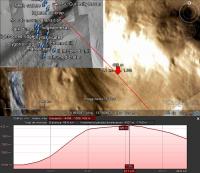
I know the altitude data on Google Earth are very coarse but, just completing what Stu already said, here's a vertical profile of a line directly connecting the landing site to the summit and showing that it is out of the line of sight (should we call it "Hidden Peak"?).
|
|
|
|
|
|
|
Aug 18 2012, 02:06 PM
Post
#52
|
|
|
The Poet Dude Group: Moderator Posts: 5551 Joined: 15-March 04 From: Kendal, Cumbria, UK Member No.: 60 |
QUOTE (climber @ Aug 18 2012, 01:25 PM) Stu (and all), can you please point out what you think will hidden our view? Written about this on my blog, if you'd like to take a look... http://galegazette.wordpress.com/2012/08/18/making-plans -------------------- |
|
|
|
|
Aug 18 2012, 02:16 PM
Post
#53
|
||
|
The Poet Dude Group: Moderator Posts: 5551 Joined: 15-March 04 From: Kendal, Cumbria, UK Member No.: 60 |
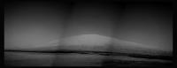
New pics down... first 'proper' view of Mt Sharp... (well, the front of it anyway!
 ) )
-------------------- |
|
|
|
|
|
|
Aug 18 2012, 02:44 PM
Post
#54
|
||
|
Solar System Cartographer Group: Members Posts: 10229 Joined: 5-April 05 From: Canada Member No.: 227 |
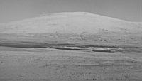
Here's a processed view of the mountain.
Phil
-------------------- ... because the Solar System ain't gonna map itself.
Also to be found posting similar content on https://mastodon.social/@PhilStooke Maps for download (free PDF: https://upload.wikimedia.org/wikipedia/comm...Cartography.pdf NOTE: everything created by me which I post on UMSF is considered to be in the public domain (NOT CC, public domain) |
|
|
|
|
|
|
Aug 18 2012, 03:01 PM
Post
#55
|
||
 Senior Member Group: Members Posts: 4256 Joined: 17-January 05 Member No.: 152 |
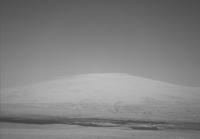
And here's an average of L and R frames, which has reduced jpeg noise quite a bit (I had to rotate and scale one frame to register them well):
Enhance/mosaic as you see fit! |
|
|
|
|
|
|
Aug 18 2012, 03:38 PM
Post
#56
|
||
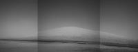
 Newbie Group: Members Posts: 8 Joined: 21-April 12 Member No.: 6382 |
PS is giving issues with panorama blending, so here is my best shot with subtle enhancement and matching of layers for the full 3 frame composite.
-------------------- |
|
|
|
|
|
|
Aug 18 2012, 03:49 PM
Post
#57
|
|
 Administrator Group: Admin Posts: 5172 Joined: 4-August 05 From: Pasadena, CA, USA, Earth Member No.: 454 |
My version. It's been a while since I did my own Mars rover image processing!

-------------------- My website - My Patreon - @elakdawalla on Twitter - Please support unmannedspaceflight.com by donating here.
|
|
|
|
|
Aug 18 2012, 03:58 PM
Post
#58
|
|
 Member Group: Members Posts: 267 Joined: 5-February 06 Member No.: 675 |
QUOTE (elakdawalla @ Aug 18 2012, 10:49 AM) My version. It's been a while since I did my own Mars rover image processing! Emily,Very nice job of nursing good detail out of 7-bit data with JPEG artifacts. Steve M |
|
|
|
|
Aug 18 2012, 04:01 PM
Post
#59
|
|
|
The Poet Dude Group: Moderator Posts: 5551 Joined: 15-March 04 From: Kendal, Cumbria, UK Member No.: 60 |
QUOTE (elakdawalla @ Aug 18 2012, 04:49 PM) My version. It's been a while since I did my own Mars rover image processing! Very nice, Emily, easily best yet
-------------------- |
|
|
|
|
Aug 18 2012, 05:36 PM
Post
#60
|
|
|
Senior Member Group: Members Posts: 2106 Joined: 13-February 10 From: Ontario Member No.: 5221 |
|
|
|
|
|

|
Lo-Fi Version | Time is now: 26th September 2024 - 12:57 AM |
|
RULES AND GUIDELINES Please read the Forum Rules and Guidelines before posting. IMAGE COPYRIGHT |
OPINIONS AND MODERATION Opinions expressed on UnmannedSpaceflight.com are those of the individual posters and do not necessarily reflect the opinions of UnmannedSpaceflight.com or The Planetary Society. The all-volunteer UnmannedSpaceflight.com moderation team is wholly independent of The Planetary Society. The Planetary Society has no influence over decisions made by the UnmannedSpaceflight.com moderators. |
SUPPORT THE FORUM Unmannedspaceflight.com is funded by the Planetary Society. Please consider supporting our work and many other projects by donating to the Society or becoming a member. |
|