East side of Cape York, Sol 3040 - 3056 |

  |
East side of Cape York, Sol 3040 - 3056 |
 Aug 29 2012, 01:50 PM Aug 29 2012, 01:50 PM
Post
#91
|
|
 Senior Member  Group: Members Posts: 4247 Joined: 17-January 05 Member No.: 152 |
QUOTE (Tesheiner @ Aug 29 2012, 11:55 AM)  The name of some imaging sequences from today say something about it. Those should have been taken before the 3056 drive, when we were still at the 3053 location surrounded by all the pretty veins. Since we've moved inland tosol, I'm guessing that we're going after the putative clays, since we're now halfway along CY. I know who I'm rooting for to reach the clays first!
|
 |
 
|
|
Aug 29 2012, 02:05 PM
Post
#92
|
||
 The Poet Dude Group: Moderator Posts: 5551 Joined: 15-March 04 From: Kendal, Cumbria, UK Member No.: 60 |
QUOTE (fredk @ Aug 29 2012, 02:50 PM) I'm guessing that we're going after the putative clays, since we're now halfway along CY. I know who I'm rooting for to reach the clays first! Well, she's heading towards these...
... so maybe it's prospecting time...  -------------------- |
|
|
|
|
|
|
Aug 29 2012, 08:28 PM
Post
#93
|
||
 Member Group: Members Posts: 404 Joined: 5-January 10 Member No.: 5161 |
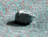
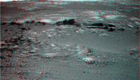
The rock from sol 3049 makes for a nice 3D.
|
|
|
|
|
|
|
Aug 29 2012, 09:12 PM
Post
#94
|
|
|
Senior Member Group: Moderator Posts: 4279 Joined: 19-April 05 From: .br at .es Member No.: 253 |
QUOTE (fredk @ Aug 29 2012, 03:50 PM) Those should have been taken before the 3056 drive, when we were still at the 3053 location surrounded by all the pretty veins. Checked it and the pancam shot was taken at the previous site but the navcam was shot "mid-drive" more or less around the 35km mark. |
|
|
|
|
Aug 29 2012, 10:17 PM
Post
#95
|
|
 Senior Member Group: Members Posts: 3419 Joined: 9-February 04 From: Minneapolis, MN, USA Member No.: 15 |
Just have a curiosity (small C) -- if we do get to some phyllosilicates, what does Oppy have left to bring to bear for examination?
I imagine we can at least brush the rock surface and the APXS should still give us some good data. And we can take some MI images. But is the Mossbauer capable of getting good spectra anymore? And if not, how much info can we get with what we got left? Again, just curious. -the other Doug -------------------- The trouble ain't that there is too many fools, but that the lightning ain't distributed right. -Mark Twain
|
|
|
|
|
Aug 29 2012, 11:27 PM
Post
#96
|
|
|
Senior Member Group: Members Posts: 4247 Joined: 17-January 05 Member No.: 152 |
After the attempt at a looooong MB integration at Greeley this winter, they decided that it was no longer useful, IIRC.
|
|
|
|
|
Aug 30 2012, 12:40 AM
Post
#97
|
|
|
Member Group: Members Posts: 507 Joined: 10-September 08 Member No.: 4338 |
QUOTE (dvandorn @ Aug 29 2012, 02:17 PM) if we do get to some phyllosilicates, what does Oppy have left to bring to bear for examination? The APXS will give elemental composition, and the MI morphology, but that may not be enough for a definitive identification. In the long run, comparison of the weak signature at Cape York with the strong signature at Cape Tribulation may be very suggestive, i.e., If there is some distinctive feature at Cape York, and a lot more of it at Cape Tribulation, then Oppy may have identified something that is correlated with the phyllosilicates. Curiosity can then investigate similar features with its full complement of instruments. |
|
|
|
|
Aug 30 2012, 06:08 AM
Post
#98
|
||
|
Junior Member Group: Members Posts: 52 Joined: 1-March 11 From: Houston, USA Member No.: 5860 |
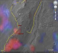
Tesheiner's map from post #89 overlaid with the CRISM data from http://www.planetary.org/blogs/emily-lakda.../2011/3134.html .
|
|
|
|
|
|
|
Aug 30 2012, 07:36 AM
Post
#99
|
|
|
Solar System Cartographer Group: Members Posts: 10179 Joined: 5-April 05 From: Canada Member No.: 227 |
The full set of filters in mutispectral images will help as well, though I don't know how much in this context.
Phil -------------------- ... because the Solar System ain't gonna map itself.
Also to be found posting similar content on https://mastodon.social/@PhilStooke Maps for download (free PD: https://upload.wikimedia.org/wikipedia/comm...Cartography.pdf NOTE: everything created by me which I post on UMSF is considered to be in the public domain (NOT CC, public domain) |
|
|
|
|
Aug 30 2012, 12:13 PM
Post
#100
|
||
|
Senior Member Group: Moderator Posts: 4279 Joined: 19-April 05 From: .br at .es Member No.: 253 |
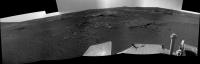
A 12m "bump" was executed on sol 3057.
Here's the "post-drive" navcam mosaic.
|
|
|
|
|
|
|
Aug 30 2012, 02:09 PM
Post
#101
|
|
|
Member Group: Members Posts: 813 Joined: 29-December 05 From: NE Oh, USA Member No.: 627 |
QUOTE (dvandorn @ Aug 29 2012, 05:17 PM) Just have a curiosity (small C) -- if we do get to some phyllosilicates, what does Oppy have left to bring to bear for examination? I imagine we can at least brush the rock surface and the APXS should still give us some good data. And we can take some MI images. But is the Mossbauer capable of getting good spectra anymore? And if not, how much info can we get with what we got left? Again, just curious. -the other Doug See this post from Stu's excellent 'Road To Endeavour' blog.... http://roadtoendeavour.wordpress.com/2011/...g-to-cape-york/ Craig |
|
|
|
|
Aug 30 2012, 02:37 PM
Post
#102
|
|
 Senior Member Group: Members Posts: 2173 Joined: 28-December 04 From: Florida, USA Member No.: 132 |
For the hard core data geeks (of which I am not one), The below paper describes in detail Spirit's evidence for phyllosilicates in Gusev.
Evidence of phyllosilicates in Wooly Patch, an altered rock encountered at West Spur, Columbia Hills, by the Spirit rover in Gusev crater, Mars "On its traverse to Columbia Hills, the Mars Exploration Rover Spirit investigated an outcrop designated ''Wooly Patch'' .... The major-element composition and Fe-mineralogy, as determined by the Alpha-Particle X-ray Spectrometer and Mossbauer Spectrometer, are inconsistent with any reasonable assemblage of basaltic minerals in that there is an excess of Si and Al. The combined data are best explained by the presence of 14–17% phyllosilicate minerals." It will be interesting to see how Opportunity's evidence for phyllosilicates at Endeavour matches up. Minus the Mossbauer data of course. |
|
|
|
|
Aug 30 2012, 08:56 PM
Post
#103
|
||||
|
The Poet Dude Group: Moderator Posts: 5551 Joined: 15-March 04 From: Kendal, Cumbria, UK Member No.: 60 |
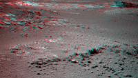
Having briefly surrendered the dancefloor it to her big, sexier sister, Oppy is definitely jumping back into the spotlight as she advances upon some fascinating geology at Cape York. Some gorgeous rock formations here, and some fascinating science to come too, I'm sure...
Colour view of the rocks around Oppy now - just a simple 4,5,6 combo; no magic spells, SKYNET supercomputer or goat sacrifices needed to make it from the raw images... 
Can't wait to see what Oppy does here! -------------------- |
|||
|
|
|
|||
|
Aug 30 2012, 09:21 PM
Post
#104
|
|
|
Senior Member Group: Members Posts: 3516 Joined: 4-November 05 From: North Wales Member No.: 542 |
I had already started to hope, and your anaglyph increases my anticipation, that these outcrops could be (at last) the everted crater rim strata we were expecting to see (but didn't) at Morris Hill. If this is the material the clays originate from then there could be a sub-Crism-resolution patch of clays right here.
|
|
|
|
|
Aug 30 2012, 11:46 PM
Post
#105
|
|
|
Senior Member Group: Members Posts: 1044 Joined: 17-February 09 Member No.: 4605 |
QUOTE (ngunn @ Aug 30 2012, 09:21 PM) ... that these outcrops could be (at last) the everted crater rim strata ...... What bends my mind is how we could differentiate between ballistically emplaced Endeavour impact ejecta / condensate and uplift rim, which would be the Miyamoto ejecta field materiel. Even if we can identify clays did they develop within the rim or were they formed in the pre Endeavour impact environment? |
|
|
|
|

|
Lo-Fi Version | Time is now: 2nd June 2024 - 09:25 PM |
|
RULES AND GUIDELINES Please read the Forum Rules and Guidelines before posting. IMAGE COPYRIGHT |
OPINIONS AND MODERATION Opinions expressed on UnmannedSpaceflight.com are those of the individual posters and do not necessarily reflect the opinions of UnmannedSpaceflight.com or The Planetary Society. The all-volunteer UnmannedSpaceflight.com moderation team is wholly independent of The Planetary Society. The Planetary Society has no influence over decisions made by the UnmannedSpaceflight.com moderators. |
SUPPORT THE FORUM Unmannedspaceflight.com is funded by the Planetary Society. Please consider supporting our work and many other projects by donating to the Society or becoming a member. |
|