MSL "Drive, drive, drive" toward Glenelg, The scientists (mostly) get the keys - sols 38-56 |

  |
MSL "Drive, drive, drive" toward Glenelg, The scientists (mostly) get the keys - sols 38-56 |
 Sep 17 2012, 03:11 PM Sep 17 2012, 03:11 PM
Post
#61
|
|
 Senior Member  Group: Moderator Posts: 3431 Joined: 11-August 04 From: USA Member No.: 98 |
|
 |
 
|
|
Sep 17 2012, 05:15 PM
Post
#62
|
|
|
Senior Member Group: Members Posts: 2922 Joined: 14-February 06 From: Very close to the Pyrénées Mountains (France) Member No.: 682 |
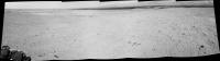
QUOTE (Stu @ Sep 17 2012, 04:52 PM)  ...and some fascinating geology in view now, too... [attachment=28150:pano_sep...2b_small.jpg] According to Phil, 3 posts higher, that's Glenelg that's showing. -------------------- |
|
|
|
|
Sep 17 2012, 05:27 PM
Post
#63
|
|
 Senior Member Group: Members Posts: 4252 Joined: 17-January 05 Member No.: 152 |
Stu's two mosaics (and Ed's in the other thread) actually fit together, so Stu's colour one is not Glenelg, but towards the west.
|
|
|
|
|
Sep 17 2012, 06:20 PM
Post
#64
|
||
|
Solar System Cartographer Group: Members Posts: 10186 Joined: 5-April 05 From: Canada Member No.: 227 |
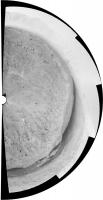
This is the sol 39 half panorama reprojected.
Phil
-------------------- ... because the Solar System ain't gonna map itself.
Also to be found posting similar content on https://mastodon.social/@PhilStooke Maps for download (free PD: https://upload.wikimedia.org/wikipedia/comm...Cartography.pdf NOTE: everything created by me which I post on UMSF is considered to be in the public domain (NOT CC, public domain) |
|
|
|
|
|
|
Sep 17 2012, 06:39 PM
Post
#65
|
|
|
Senior Member Group: Moderator Posts: 3431 Joined: 11-August 04 From: USA Member No.: 98 |
QUOTE (fredk @ Sep 17 2012, 11:27 AM) Stu's two mosaics (and Ed's in the other thread) actually fit together, so Stu's colour one is not Glenelg, but towards the west. Specifically here |
|
|
|
|
Sep 17 2012, 07:37 PM
Post
#66
|
|
|
Junior Member Group: Members Posts: 30 Joined: 7-March 04 Member No.: 51 |
It looks like a small outcrop of the high TI unit 100+ m south of Bradbury Landing. It shows up well in this MRO image from Emily's blog.
https://planetary.s3.amazonaws.com/assets/i...29_PIA16148.jpg |
|
|
|
|
Sep 17 2012, 08:33 PM
Post
#67
|
|||
|
Solar System Cartographer Group: Members Posts: 10186 Joined: 5-April 05 From: Canada Member No.: 227 |
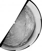
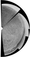
A couple more reprojected panoramas to help with locations. The full circle is from sol 29 but as the rover was still here on the morning of sol 38 I can slip it in here (to keep them all together).
Phil Sols 29-37:
Sol 38:
-------------------- ... because the Solar System ain't gonna map itself.
Also to be found posting similar content on https://mastodon.social/@PhilStooke Maps for download (free PD: https://upload.wikimedia.org/wikipedia/comm...Cartography.pdf NOTE: everything created by me which I post on UMSF is considered to be in the public domain (NOT CC, public domain) |
||
|
|
|
||
|
Sep 18 2012, 04:59 AM
Post
#68
|
|
 Senior Member Group: Members Posts: 2228 Joined: 1-December 04 From: Marble Falls, Texas, USA Member No.: 116 |
-------------------- ...Tom
I'm not a Space Fan, I'm a Space Exploration Enthusiast. |
|
|
|
|
Sep 18 2012, 11:29 AM
Post
#69
|
||
|
Senior Member Group: Moderator Posts: 4279 Joined: 19-April 05 From: .br at .es Member No.: 253 |
QUOTE (mhoward @ Sep 17 2012, 05:11 PM) Sol 41, another step closer. A navcam mosaic.
|
|
|
|
|
|
|
Sep 18 2012, 12:22 PM
Post
#70
|
|
|
Member Group: Members Posts: 470 Joined: 24-March 04 From: Finland Member No.: 63 |
Sol 42 drive images are up. The shadows are long and the dynamic range in the navcam images appears quite high. We've been roving late into the afternoon?
-------------------- Antti Kuosmanen
|
|
|
|
|
Sep 18 2012, 12:30 PM
Post
#71
|
|
 Senior Member Group: Members Posts: 1465 Joined: 9-February 04 From: Columbus OH USA Member No.: 13 |
QUOTE (akuo @ Sep 18 2012, 08:22 AM) Sol 42 drive images are up. The shadows are long and the dynamic range in the navcam images appears quite high. We've been roving late into the afternoon? About 3:30pm LMST, about 2 hours before sunset. The sun is practically just directly behind the camera in the highest-contrast ones, which might explain the brightness toward the center (backscatter). -------------------- |
|
|
|
|
Sep 18 2012, 12:40 PM
Post
#72
|
|
|
Member Group: Members Posts: 282 Joined: 18-June 04 Member No.: 84 |
They look very "MER" like now....and different JPEG compression? Look at the horizon/sky
http://mars.jpl.nasa.gov/msl-raw-images/pr...NCAM00427M_.JPG http://mars.jpl.nasa.gov/msl-raw-images/pr...NCAM00427M_.JPG Compare to this from Spirit on SOL 74 NAVCAM: http://marsrovers.jpl.nasa.gov/gallery/all...00P1827R0M1.JPG |
|
|
|
|
Sep 18 2012, 01:41 PM
Post
#73
|
|
|
Senior Member Group: Members Posts: 2922 Joined: 14-February 06 From: Very close to the Pyrénées Mountains (France) Member No.: 682 |
QUOTE (fredk @ Sep 17 2012, 07:27 PM) Stu's two mosaics (and Ed's in the other thread) actually fit together, so Stu's colour one is not Glenelg, but towards the west. Sorry Stu & All, my bad. -------------------- |
|
|
|
|
Sep 18 2012, 02:09 PM
Post
#74
|
||
|
Solar System Cartographer Group: Members Posts: 10186 Joined: 5-April 05 From: Canada Member No.: 227 |
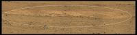
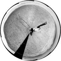
Sol 41 half-panorama reprojected. This enables a very good match to topography, confirming the previous estimate (or very near it) despite me saying it might have to change in the route map thread. But sol 40 had to be changed, as the new map shows.
Phil
-------------------- ... because the Solar System ain't gonna map itself.
Also to be found posting similar content on https://mastodon.social/@PhilStooke Maps for download (free PD: https://upload.wikimedia.org/wikipedia/comm...Cartography.pdf NOTE: everything created by me which I post on UMSF is considered to be in the public domain (NOT CC, public domain) |
|
|
|
|
|
|
Sep 18 2012, 02:49 PM
Post
#75
|
|||
 Senior Member Group: Members Posts: 3419 Joined: 9-February 04 From: Minneapolis, MN, USA Member No.: 15 |
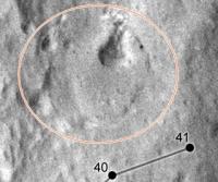
I'm assuming that the marked areas in the next two images, from above and from the surface, are the same feature?
From above, this feature looks, at first glance, to have a crater morphology (until you look closely and see that its edges are in positive, rather than negative, relief). From the ground, it kind of resembles a miniature version of Home Plate. As Stu said -- fascinating geology. Almost looks like a sedimentary process laid down a fill inside a small crater which has been more resistant to erosion than the surface in which the crater was originally formed. -the other Doug -------------------- The trouble ain't that there is too many fools, but that the lightning ain't distributed right. -Mark Twain
|
||
|
|
|
||
|

|
Lo-Fi Version | Time is now: 6th June 2024 - 03:06 AM |
|
RULES AND GUIDELINES Please read the Forum Rules and Guidelines before posting. IMAGE COPYRIGHT |
OPINIONS AND MODERATION Opinions expressed on UnmannedSpaceflight.com are those of the individual posters and do not necessarily reflect the opinions of UnmannedSpaceflight.com or The Planetary Society. The all-volunteer UnmannedSpaceflight.com moderation team is wholly independent of The Planetary Society. The Planetary Society has no influence over decisions made by the UnmannedSpaceflight.com moderators. |
SUPPORT THE FORUM Unmannedspaceflight.com is funded by the Planetary Society. Please consider supporting our work and many other projects by donating to the Society or becoming a member. |
|


 I can't wait.