Vertical Projections |

  |
Vertical Projections |
 Sep 6 2005, 12:34 PM Sep 6 2005, 12:34 PM
Post
#1
|
|||
|
Senior Member  Group: Moderator Posts: 4279 Joined: 19-April 05 From: .br at .es Member No.: 253 |
Dilo,
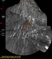
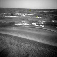
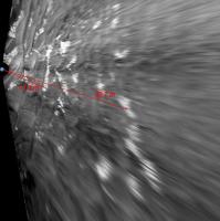
First of all, let me say again that your vertical projections are an excellent job and a good way to follow the rover progress and match it with MOC images. Even if it is/was quite easy to match the outcrops seen on your maps with the orbiter imagery, it is true that I was only successful with near features on the range up to 10 meters. Farther outcrops didnt match, including what I supose is the highway. What I have found is that there is an error factor on those projections that increases with the distance. In other words, the outcrops look farther than they actually are. For instance: the feature A Ive picked on your last route map (see below) is supposedly at 13.1 m from the camera.
However, the same feature, which can be identified on the original images from sol 569 (see below), is calculated to be at 11.1m using the MER Parallax Calculator or at 11.74m using the elevation (pitch) angle.
Similar case for the feature B. It is at 41.3m per your route map and at 34.8m (plus/minus 2.5m) according to parallax. By taking the elevation angle, the result is 32.6m. Do you (or anybody else) know which is the reason for this discrepancy, and if it can be corrected? If it could, I think that those projections would fit orbital imagery even better then now, matching almost all the outcrops seen by the rover up to the Erebus Highway. |
||
 |
 
|
||
|
Sep 6 2005, 09:00 PM
Post
#2
|
|
 Senior Member Group: Members Posts: 2492 Joined: 15-January 05 From: center Italy Member No.: 150 |
Interesting observation, Tesheiner...
I have to check, but possible explaination is that terrain is not flat, so overestimated distance could arise from slightly higher level of the Erebus highway compared to Rover location. This should be easily verifiable through parallax measurements and your elevation measure seems to confirm this model... Anyway, I must underline that my projection method is far from perfection. In fact, due to difficulty to obtain a perfectly flat horizon with AutoStitch, even absolutely flat terrain should produce some imperfections in estimated distance for some particular azimut values (especially near the edges of the panorama stitch). Finally, remember that dunes can partially/completely hide the far outcrops... For these reasons, I avoid to extend vertical projections too far. Thanks. -------------------- I always think before posting! - Marco -
|
|
|
|
|
Sep 7 2005, 12:27 AM
Post
#3
|
||
|
Senior Member Group: Members Posts: 2492 Joined: 15-January 05 From: center Italy Member No.: 150 |
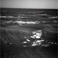
Based on Tesheiner observation, in my last route map update I made a slight correction on Sol574 new vertical projection.
In pratice, I corrected local slope of the projection plane in order to match distance with parallax value of the small outcrop indicated by red arrow (18.9m).
The correction was pretty small (0.6 deg in East direction) but now Erebus highway appear clearly closer than in Sol569 projection. Tesheiner, can you make a smart verify on my figures/projection, pls? -------------------- I always think before posting! - Marco -
|
|
|
|
|
|
|
Sep 7 2005, 07:35 AM
Post
#4
|
|
|
Senior Member Group: Moderator Posts: 4279 Joined: 19-April 05 From: .br at .es Member No.: 253 |
QUOTE (dilo @ Sep 6 2005, 11:00 PM) Interesting observation, Tesheiner... I have to check, but possible explaination is that terrain is not flat, so overestimated distance could arise from slightly higher level of the Erebus highway compared to Rover location. This should be easily verifiable through parallax measurements and your elevation measure seems to confirm this model...  Dilo, I have a different hipotesis. If I'm right, your projections are actually based on elevation angles and, as you already stated, imperfections on the stitched panorama are exaggerated on the vertical projection and this effect can be quite big near the horizont i.e. far features. So, here is the point. The horizon is not exactly at 0º elevation but at -0.44º. The terrain should still be considered as flat, but the image to be projected (i.e. the stitched panorama) should be tilted down 0.44 degrees. This small angle makes no difference (or quite small) to the near objects but the effect on far objects is impressive. Note: If you already took this effect into account, please just put this post into the trash can. 
|
|
|
|
|
Sep 8 2005, 06:29 AM
Post
#5
|
|||
|
Senior Member Group: Members Posts: 2492 Joined: 15-January 05 From: center Italy Member No.: 150 |
Tesheiner, your hypotesys cannot explain discrepancy.
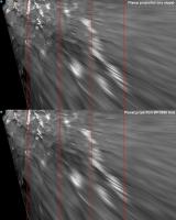
In fact, horizon depression from 1.5m above terrain (the NavCam height) should be only 0.05 degree, which correspond to about 1 pixel. A projection to a sphere with the Mars dimension should account for this effect and, as you can see in this comparison, differences are absolutely negligible:
However, looking better to original panorama stitch I discovered the real glitch. As mentioned above, autostich often fail to make perfectly flat horizon. Before to make vertical projection, I try to minimize this issue through appropiate image rotation, but in this case this wasn't sufficient and (I must admit) I underestimated effect of "residual" imperfections on final result. Below, I repeated the projection by minimizing error on the azimut direction of feature you highlighted. In fact, now they appear really closer and in perfect agreement with parallax-based estimation!
This is an important lesson learned. I must apologize and I will pay more attention in making vertical projections, thanks! -------------------- I always think before posting! - Marco -
|
||
|
|
|
||
|
Sep 8 2005, 06:47 AM
Post
#6
|
|
|
Senior Member Group: Moderator Posts: 4279 Joined: 19-April 05 From: .br at .es Member No.: 253 |
Dilo,
Now I realize that I just used Spirit's horizon depression (0.44º) for Opportunity too!  (***) (***)Well, it would be nice to see Oppy also some 90m above the ground. Don't you think so? Sorry for my mistake. Anyway, I'm glad to know you found the source of the discrepancy. Thanks for the effort. (***) Doug, may I suggest a new smiley? One knocking its head on the table (or on the wall). |
|
|
|
|

|
Lo-Fi Version | Time is now: 26th May 2024 - 11:52 PM |
|
RULES AND GUIDELINES Please read the Forum Rules and Guidelines before posting. IMAGE COPYRIGHT |
OPINIONS AND MODERATION Opinions expressed on UnmannedSpaceflight.com are those of the individual posters and do not necessarily reflect the opinions of UnmannedSpaceflight.com or The Planetary Society. The all-volunteer UnmannedSpaceflight.com moderation team is wholly independent of The Planetary Society. The Planetary Society has no influence over decisions made by the UnmannedSpaceflight.com moderators. |
SUPPORT THE FORUM Unmannedspaceflight.com is funded by the Planetary Society. Please consider supporting our work and many other projects by donating to the Society or becoming a member. |
|