Heading south from Cape York, Opportunity's post-conjunction adventures / Sol 3291 - 3387 |

  |
Heading south from Cape York, Opportunity's post-conjunction adventures / Sol 3291 - 3387 |
 Jul 17 2013, 03:11 PM Jul 17 2013, 03:11 PM
Post
#346
|
|
|
Solar System Cartographer  Group: Members Posts: 10168 Joined: 5-April 05 From: Canada Member No.: 227 |
That looks good - better than what I was thinking.
Phil -------------------- ... because the Solar System ain't gonna map itself.
Also to be found posting similar content on https://mastodon.social/@PhilStooke Maps for download (free PD: https://upload.wikimedia.org/wikipedia/comm...Cartography.pdf NOTE: everything created by me which I post on UMSF is considered to be in the public domain (NOT CC, public domain) |
 |
 
|
|
Jul 17 2013, 03:20 PM
Post
#347
|
|
 Senior Member Group: Moderator Posts: 3431 Joined: 11-August 04 From: USA Member No.: 98 |
Sorry, perhaps I should have said the craterlet is well-defined in stereo. Obviously nothing is that clear around here, but relative to some of the other recent landmarks this craterlet stands out like Split Rock Lighthouse IMHO. I was excited to see it.
Here's where I think she is. fredk: I think those make sense, myself. |
|
|
|
|
Jul 17 2013, 03:49 PM
Post
#348
|
|
|
Solar System Cartographer Group: Members Posts: 10168 Joined: 5-April 05 From: Canada Member No.: 227 |
Mike, just below the '6' in your '3369' is a very subdued crater, and there's a very faint crater SE of the rover in my reprojection - I was trying to match those two and thinking the prominent rocky-rimmed crater was just outside of the panorama - but I am much more impressed with the new location. I will adjust the map later.
Phil -------------------- ... because the Solar System ain't gonna map itself.
Also to be found posting similar content on https://mastodon.social/@PhilStooke Maps for download (free PD: https://upload.wikimedia.org/wikipedia/comm...Cartography.pdf NOTE: everything created by me which I post on UMSF is considered to be in the public domain (NOT CC, public domain) |
|
|
|
|
Jul 17 2013, 10:33 PM
Post
#349
|
|
|
Senior Member Group: Moderator Posts: 3431 Joined: 11-August 04 From: USA Member No.: 98 |
Of general interest to Opportunity followers: HiRISE "Opportunity's Journey at Endeavour Crater". Great stuff.
|
|
|
|
|
Jul 17 2013, 10:51 PM
Post
#350
|
|
 Senior Member Group: Members Posts: 4247 Joined: 17-January 05 Member No.: 152 |
Shows that Phil's 3360 location was pretty much perfect. Unfortunately, tracks don't show well on this surface, so the image can't be used to check the previous positions.
Always cool to see our gal from orbit, though! |
|
|
|
|
Jul 17 2013, 11:21 PM
Post
#351
|
|
|
Senior Member Group: Moderator Posts: 3431 Joined: 11-August 04 From: USA Member No.: 98 |
Be sure to check out the "Merged RGB: map-projected" JP2 product, under "JP2 Extras", if you can. Everything from Cape York down to Solander Point and beyond, in glorious false color. Absolutely amazing.
Or, just check out Emily's blog post. |
|
|
|
|
Jul 17 2013, 11:28 PM
Post
#352
|
|
|
Solar System Cartographer Group: Members Posts: 10168 Joined: 5-April 05 From: Canada Member No.: 227 |
No tracks in Botany Bay, for sure, but quite a few on Cape York itself, at least on Matijevic Hill and south of it.
Phil -------------------- ... because the Solar System ain't gonna map itself.
Also to be found posting similar content on https://mastodon.social/@PhilStooke Maps for download (free PD: https://upload.wikimedia.org/wikipedia/comm...Cartography.pdf NOTE: everything created by me which I post on UMSF is considered to be in the public domain (NOT CC, public domain) |
|
|
|
|
Jul 18 2013, 12:12 AM
Post
#353
|
|
 Senior Member Group: Members Posts: 3419 Joined: 9-February 04 From: Minneapolis, MN, USA Member No.: 15 |
Gee -- almost everywhere else Oppy has been at Meridiani has had enough soil (or regolith, take your pick) to leave good, recognizable tracks, even in the absence of ripples/drifts. I wonder what processes are at work here in the Bay to strip a majority of the fines that you'd otherwise expect?
-the other Doug -------------------- The trouble ain't that there is too many fools, but that the lightning ain't distributed right. -Mark Twain
|
|
|
|
|
Jul 18 2013, 12:11 PM
Post
#354
|
|
 Senior Member Group: Members Posts: 1619 Joined: 12-February 06 From: Bergerac - FR Member No.: 678 |
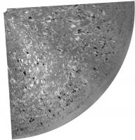
Mosaic of the rocky floor toward the crater (Sol 3369) :

-------------------- |
|
|
|
|
Jul 18 2013, 02:07 PM
Post
#355
|
||
|
Senior Member Group: Moderator Posts: 3431 Joined: 11-August 04 From: USA Member No.: 98 |
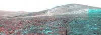
Here's a first attempt at an anaglyph for the sol 3366 long baseline stereo Pancam mosaic. Not quite all of the images are down yet.
Attached thumbnail(s)
|
|
|
|
|
|
|
Jul 19 2013, 01:58 AM
Post
#356
|
|
|
Senior Member Group: Moderator Posts: 3431 Joined: 11-August 04 From: USA Member No.: 98 |
About 60.5m on Sol 3371. Here's where I think she is... I wanted to see how this worked on the color map. I like the color, but I think it's easier to do the actual mapping on the slightly higher resolution grayscale image.
|
|
|
|
|
Jul 19 2013, 02:01 AM
Post
#357
|
|
 Administrator Group: Admin Posts: 5172 Joined: 4-August 05 From: Pasadena, CA, USA, Earth Member No.: 454 |
Did you try the color image I posted in my blog? I draped the color over the higher-res red image.
-------------------- My website - My Patreon - @elakdawalla on Twitter - Please support unmannedspaceflight.com by donating here.
|
|
|
|
|
Jul 19 2013, 02:55 AM
Post
#358
|
|
|
Senior Member Group: Moderator Posts: 3431 Joined: 11-August 04 From: USA Member No.: 98 |
I hadn't noticed that you'd done it that way; that's actually quite nice. Here are the positions redone on your background.
I think using grayscale ESP_018701_1775_RED.JP2 is still somehow easier, though. I'm not at all confident of the sol 3371 position; once again, few images and very subtle landmarks. But it should be in the ballpark. Probably. |
|
|
|
|
Jul 19 2013, 03:44 AM
Post
#359
|
||
|
Solar System Cartographer Group: Members Posts: 10168 Joined: 5-April 05 From: Canada Member No.: 227 |
Very tricky! I don't have a location to suggest but I can offer this reprojection of the two navcams we have so far.
Phil
-------------------- ... because the Solar System ain't gonna map itself.
Also to be found posting similar content on https://mastodon.social/@PhilStooke Maps for download (free PD: https://upload.wikimedia.org/wikipedia/comm...Cartography.pdf NOTE: everything created by me which I post on UMSF is considered to be in the public domain (NOT CC, public domain) |
|
|
|
|
|
|
Jul 19 2013, 03:06 PM
Post
#360
|
|
|
Senior Member Group: Members Posts: 4247 Joined: 17-January 05 Member No.: 152 |
A bit more info about the recent downward drives in the latest update:
QUOTE they decided to use a few of the margin sols accumulated to investigate an area of interesting terrain and gypsum signatures.
|
|
|
|
|

|
Lo-Fi Version | Time is now: 26th May 2024 - 01:31 PM |
|
RULES AND GUIDELINES Please read the Forum Rules and Guidelines before posting. IMAGE COPYRIGHT |
OPINIONS AND MODERATION Opinions expressed on UnmannedSpaceflight.com are those of the individual posters and do not necessarily reflect the opinions of UnmannedSpaceflight.com or The Planetary Society. The all-volunteer UnmannedSpaceflight.com moderation team is wholly independent of The Planetary Society. The Planetary Society has no influence over decisions made by the UnmannedSpaceflight.com moderators. |
SUPPORT THE FORUM Unmannedspaceflight.com is funded by the Planetary Society. Please consider supporting our work and many other projects by donating to the Society or becoming a member. |
|