Journey to Mt Sharp - Part 4: Beyond the Kimberley, Sol 634 [May 19, '14] to 706 [Jul 31, '14] |

  |
Journey to Mt Sharp - Part 4: Beyond the Kimberley, Sol 634 [May 19, '14] to 706 [Jul 31, '14] |
 May 25 2014, 09:14 AM May 25 2014, 09:14 AM
Post
#46
|
|
|
Member  Group: Members Posts: 866 Joined: 15-March 05 From: Santa Cruz, CA Member No.: 196 |
|
 |
 
|
|
May 25 2014, 06:51 PM
Post
#47
|
|
|
Member Group: Members Posts: 913 Joined: 4-September 06 From: Boston Member No.: 1102 |
I guess with the holiday weekend we won't move towards or get any images of the large rocks/meteorites until Wednesday. Hard to wait sometimes...
-------------------- |
|
|
|
|
May 26 2014, 10:34 AM
Post
#48
|
|
 Member Group: Members Posts: 691 Joined: 21-December 07 From: Clatskanie, Oregon Member No.: 3988 |
Definitely a metal object!
 
|
|
|
|
|
May 26 2014, 10:50 AM
Post
#49
|
|
 Senior Member Group: Members Posts: 1465 Joined: 9-February 04 From: Columbus OH USA Member No.: 13 |
Is there a compelling scientific reason for MSL to analyze an iron-nickel meteor further (drive over there, etc)?
-------------------- |
|
|
|
|
May 26 2014, 11:01 AM
Post
#50
|
|
 Senior Member Group: Members Posts: 2430 Joined: 30-January 13 From: Penang, Malaysia. Member No.: 6853 |
QUOTE (jmknapp @ May 26 2014, 06:50 PM)  Is there a compelling scientific reason for MSL to analyze an iron-nickel meteor further (drive over there, etc)? According to 'Midnight Planets' Curiosity is driving now (awaiting metadata) we will have to see where she is going |
|
|
|
|
May 26 2014, 12:05 PM
Post
#51
|
||
|
Senior Member Group: Members Posts: 1074 Joined: 21-September 07 From: Québec, Canada Member No.: 3908 |
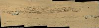
Sol 637 mastcam 100 view of the two "rocks":
If these are meteorites (as they appear to be), isn't it quite a coincidence that they are so close together? Unless they are part of a larger body that broke up either on its way down or upon impact. |
|
|
|
|
|
|
May 26 2014, 03:47 PM
Post
#52
|
|
|
Senior Member Group: Members Posts: 1465 Joined: 9-February 04 From: Columbus OH USA Member No.: 13 |
QUOTE (PaulH51 @ May 26 2014, 06:01 AM) According to 'Midnight Planets' Curiosity is driving now (awaiting metadata) we will have to see where she is going The SPICE position file was finally updated this morning after several days, but it just has a couple of of short bumps yesterday (sol 640), maybe spurious. I was just wondering given the overall aim of the effort (characterizing the "lacustrine" history of the crater, etc.), if an extraterrestrial rock is on point. -------------------- |
|
|
|
|
May 26 2014, 03:52 PM
Post
#53
|
|
 Senior Member Group: Moderator Posts: 3431 Joined: 11-August 04 From: USA Member No.: 98 |
The bumps aren't spurious (I don't think); typical wheel examination (see bottom of page).
Gorgeous (and probably practical in some way?) early morning lighting, too. |
|
|
|
|
May 26 2014, 03:57 PM
Post
#54
|
|
|
Solar System Cartographer Group: Members Posts: 10183 Joined: 5-April 05 From: Canada Member No.: 227 |
The short bumps are not spurious, they are doing wheel imaging with small rotations between images.
Checking whether these rocks are meteorites is a worthy goal - not enough for a long stop, but I would suggest it would be useful to get ChemCam LIBS data on them to compare with APXS which we have for the Meridiani meteorites. As for clustering, Spirit also say 2 or possibly 3 meteorites at Low Ridge Haven, and at Meridiani Shelter Island and Mackinac Island were also close together. Atmospheric breakup seems quite likely. Phil -------------------- ... because the Solar System ain't gonna map itself.
Also to be found posting similar content on https://mastodon.social/@PhilStooke Maps for download (free PD: https://upload.wikimedia.org/wikipedia/comm...Cartography.pdf NOTE: everything created by me which I post on UMSF is considered to be in the public domain (NOT CC, public domain) |
|
|
|
|
May 26 2014, 04:01 PM
Post
#55
|
|||
|
Solar System Cartographer Group: Members Posts: 10183 Joined: 5-April 05 From: Canada Member No.: 227 |
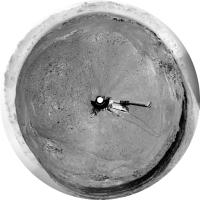
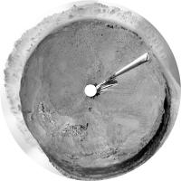
These are circular views from sols 636 and 637 showing recent drives and surrounding features.
Phil 636:
637:
-------------------- ... because the Solar System ain't gonna map itself.
Also to be found posting similar content on https://mastodon.social/@PhilStooke Maps for download (free PD: https://upload.wikimedia.org/wikipedia/comm...Cartography.pdf NOTE: everything created by me which I post on UMSF is considered to be in the public domain (NOT CC, public domain) |
||
|
|
|
||
|
May 26 2014, 10:35 PM
Post
#56
|
|
|
Senior Member Group: Members Posts: 1045 Joined: 17-February 09 Member No.: 4605 |
QUOTE (jmknapp @ May 26 2014, 10:50 AM) Is there a compelling scientific reason for MSL to analyze an iron-nickel meteor further (drive over there, etc)? Assuming that they are, as they seem, iron meteorites then the impact must have occurred when there was a reasonably thick atmosphere and an appreciable depth of material (sandstone / mud / water) above their present level since there is no trace of impact excavation and no appreciable fragmentation, although the original could perhaps have split in half, potentially just before impact. So a closer examination could give an important data point on the environment post impact. Besides, how could an entity named Curiosity fail to have a quick look? |
|
|
|
|
May 26 2014, 10:47 PM
Post
#57
|
|
|
Member Group: Members Posts: 201 Joined: 16-December 13 Member No.: 7067 |
Hopefully ChemCam got some good distance zaps in, because that rock (meteorite for sure?) is now far in the rear-view mirror!
 (just thumbnails for now) (just thumbnails for now)I've been surprised by how far west we've headed - I guess that way lies flatter ground for longer drives. And softer ground - because unlike Opportunity's solar arrays, the wheels aren't getting any better |
|
|
|
|
May 26 2014, 11:12 PM
Post
#58
|
|
|
Member Group: Members Posts: 140 Joined: 20-November 07 Member No.: 3967 |
QUOTE (serpens @ May 26 2014, 05:35 PM) . . . reasonably thick atmosphere . . . appreciable depth of material . . . no trace of impact excavation . . . no appreciable fragmentation, . . . closer examination could give an important data point . . . . Besides, how could an entity named Curiosity fail to have a quick look? Applause! (Is the obvious really obvious until someone states it precisely and clearly?) |
|
|
|
|
May 27 2014, 12:05 AM
Post
#59
|
|
|
Senior Member Group: Members Posts: 1465 Joined: 9-February 04 From: Columbus OH USA Member No.: 13 |
-------------------- |
|
|
|
|
May 27 2014, 12:06 AM
Post
#60
|
||
|
Solar System Cartographer Group: Members Posts: 10183 Joined: 5-April 05 From: Canada Member No.: 227 |
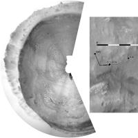
Very quick circular pan and sketch map - proper map update tomorrow.
Phil
-------------------- ... because the Solar System ain't gonna map itself.
Also to be found posting similar content on https://mastodon.social/@PhilStooke Maps for download (free PD: https://upload.wikimedia.org/wikipedia/comm...Cartography.pdf NOTE: everything created by me which I post on UMSF is considered to be in the public domain (NOT CC, public domain) |
|
|
|
|
|
|

|
Lo-Fi Version | Time is now: 4th June 2024 - 11:11 PM |
|
RULES AND GUIDELINES Please read the Forum Rules and Guidelines before posting. IMAGE COPYRIGHT |
OPINIONS AND MODERATION Opinions expressed on UnmannedSpaceflight.com are those of the individual posters and do not necessarily reflect the opinions of UnmannedSpaceflight.com or The Planetary Society. The all-volunteer UnmannedSpaceflight.com moderation team is wholly independent of The Planetary Society. The Planetary Society has no influence over decisions made by the UnmannedSpaceflight.com moderators. |
SUPPORT THE FORUM Unmannedspaceflight.com is funded by the Planetary Society. Please consider supporting our work and many other projects by donating to the Society or becoming a member. |
|