Dawn's Survey Orbit at Ceres |

  |
Dawn's Survey Orbit at Ceres |
 Jun 24 2015, 05:49 PM Jun 24 2015, 05:49 PM
Post
#91
|
||
 Member  Group: Members Posts: 714 Joined: 3-January 08 Member No.: 3995 |
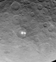
QUOTE (ZLD @ Jun 20 2015, 12:36 PM)  .... I haven't heard much about the possibility of a periodic atmosphere around Ceres recently. Has there been any more debate on this? QUOTE (JRehling @ Jun 24 2015, 11:26 AM) .... The water blasting out at the surface would probably undergo a lot of evaporation and loss into space, although perhaps it could have caused a significant temporary atmosphere. .... With darkish, plume-like features like the ones extending from spot #5:
I can't help but think about the possibility of a temporary atmosphere. |
|
 |
 
|
|
|
Jun 24 2015, 05:58 PM
Post
#92
|
|||
|
Member Group: Members Posts: 714 Joined: 3-January 08 Member No.: 3995 |
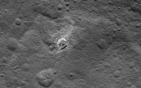
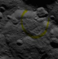
QUOTE (FOV @ Jun 24 2015, 11:28 AM) Polar region crater with more of the light coloured material:
That feature does look similar to this:
Both may be where impacts exposed subsurface intrusions of the white stuff. |
||
|
|
|
||
|
Jun 24 2015, 06:17 PM
Post
#93
|
|
 Member Group: Members Posts: 423 Joined: 13-November 14 From: Norway Member No.: 7310 |
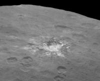
The lower half of that bright crater has a really strange appearance. Looks like something has modified it (like a later impact or two).
-------------------- |
|
|
|
|
Jun 24 2015, 08:18 PM
Post
#94
|
|||
 Member Group: Members Posts: 555 Joined: 27-September 10 Member No.: 5458 |
It gets even stranger looking if you flip it upside down.
I almost think an impact actually pushed the soil upward and out into a sort of hanging cliff? Also, another oddity crater from SOrb12
Zero clue here. I got nothing. -------------------- |
||
|
|
|
||
|
Jun 24 2015, 08:26 PM
Post
#95
|
|
 Senior Member Group: Members Posts: 2530 Joined: 20-April 05 Member No.: 321 |
QUOTE (Gladstoner @ Jun 24 2015, 10:58 AM) Both may be where impacts exposed subsurface intrusions of the white stuff. I'm looking at photos of Ganymede, which has a lot of rayed craters that exposed bright, subsurface ice. The phenomenon on Ceres is definitely something different. Related, perhaps, but every example on Ganymede has common characteristics that none of the examples on Ceres match. If this is a mere "ray" event (also visible on the Moon, Mercury, etc.), then there's something very different on Ceres about how the material is surfaced or how it ages. I'd guess we're either seeing the remnants of a ray system that sputters away quite differently than the rays on Ganymede, et al, do, or these are eruptions. If it were simply subsurface salt, I'd expect them to look like Ganymede/Moon rays and to be less selective in their occurrence. Perhaps icy ray material on Ceres is coarse near the point of origin and sparse far from it and therefore sputters away rapidly except where it's most coarse. Eg, a 20 kg lump of ice may stick around much, much longer than lots of microgram particles. Alternately, I'd stick with the idea of eruptions: Which may be triggered when the impact occurs, or possibly much later. |
|
|
|
|
Jun 24 2015, 09:00 PM
Post
#96
|
|
 Senior Member Group: Members Posts: 2173 Joined: 28-December 04 From: Florida, USA Member No.: 132 |
QUOTE (ZLD @ Jun 24 2015, 03:18 PM) 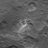 I almost think an impact actually pushed the soil upward and out into a sort of hanging cliff? The white rays spray out in the opposite direction of the dirt pile. It doesn't look like both could be the result of "impact push". Maybe an impactor hit a sub-surface bed of salty ice. The white spray is the salt left from icy ejecta. The impact melted the sub surface ice leading to a sinkhole-like slump on the side of the crater opposite the white rays. I'll try to resist any further amateur speculations. 
|
|
|
|
|
Jun 24 2015, 09:06 PM
Post
#97
|
|
|
Senior Member Group: Members Posts: 3516 Joined: 4-November 05 From: North Wales Member No.: 542 |
QUOTE (JRehling @ Jun 24 2015, 09:26 PM) a 20 kg lump of ice may stick around much, much longer than lots of microgram particles Do you mean long on a geological timescale? Do you have a very rough estimate for the length of time a 20kg lump would last? |
|
|
|
|
Jun 24 2015, 09:10 PM
Post
#98
|
||
|
Member Group: Members Posts: 714 Joined: 3-January 08 Member No.: 3995 |
QUOTE (JRehling @ Jun 24 2015, 03:26 PM) If it were simply subsurface salt, I'd expect them to look like Ganymede/Moon rays and to be less selective in their occurrence. This is why I suspect much of the white stuff is in the form of intrusions (veins, dikes, 'volcanic necks', etc.) in places deep beneath the surface. A terrestrial comparison I have in mind is pegmatite, which is the solid end point of granitic magma crystallization. On Ceres, the 'granite' would be water ice, and the 'pegmatite' would be the leftover material that could not be incorporated into the ice crystals. This 'pegmatitic magma', which would be a concentrated brine containing various salt and volatiles (CO2, NH3, etc.) would either dry or freeze out in place or eventually make it to the surface as an extrusion of some kind. The entrained gases would help to drive the eruption as they do on Earth. Spot #5 could be the best -- or only -- example where this brine breached the surface due to eruption rather than by exposure due to impact or mass wasting. Edit 1: In many spots, this material may merely permeate existing fractures within the megabreccia (think of mineral veins on Mars). In these cases, the intrusions may resemble petroleum reserves more than they do magmatic plutons. Edit 2: And speaking of crater rays, I would not expect exposed water ice to remain for long after an impact excavated and dispersed it like this (assuming all white material is the same stuff):
|
|
|
|
|
|
|
Jun 24 2015, 09:42 PM
Post
#99
|
|
|
Senior Member Group: Members Posts: 2530 Joined: 20-April 05 Member No.: 321 |
I see a citation from Lanzerotti, et al, 1978 to the effect that:
Solar wind erosion for pure water ice is about 10 angstroms per year at 1 AU and falls off with the inverse square of the distance. So, at Ceres, about 3 angstroms per year. At that rate, a 10 cm ice layer would vanish entirely in about 300 million years. That's longer than the age of Tycho on the Moon, and about as old as Aristarchus. So, chunks about 30 cm across would survive near younger craters, but not near older ones, and snowflakes would disappear almost instantly in geological terms. |
|
|
|
|
Jun 24 2015, 09:59 PM
Post
#100
|
|
 Senior Member Group: Members Posts: 1643 Joined: 5-March 05 From: Boulder, CO Member No.: 184 |
Would the ice sublimation rate be greater than the solar wind erosion rate at the ambient temperatures? The moon provides some guidance:
http://people.nwra.com/resumes/andreas/pub...Icarus_Moon.pdf -------------------- Steve [ my home page and planetary maps page ]
|
|
|
|
|
Jun 24 2015, 10:05 PM
Post
#101
|
|
|
Member Group: Members Posts: 714 Joined: 3-January 08 Member No.: 3995 |
QUOTE (JRehling @ Jun 24 2015, 03:42 PM) I see a citation from Lanzerotti, et al, 1978 to the effect that: ........ So, chunks about 30 cm across would survive near younger craters, but not near older ones, and snowflakes would disappear almost instantly in geological terms. If the stuff indeed is ice, then 1) pure ice would still be in the form of scattered or isolated intrusions (since it is sporadic in occurrence), and 2) constraints could be made on the form that the ice takes on the surface, e.g. larger particles would be more likely to remain than smaller grains or frost. |
|
|
|
|
Jun 24 2015, 10:15 PM
Post
#102
|
||
 Newbie Group: Members Posts: 11 Joined: 13-May 15 Member No.: 7464 |
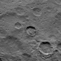
From today's PIA19581, upper right. It almost looks like a mudslide from the impact on the rim
There are also a couple of nice central peak shadows at the upper terminator in the TIFF. |
|
|
|
|
|
|
Jun 24 2015, 11:05 PM
Post
#103
|
|
|
Member Group: Members Posts: 315 Joined: 1-October 06 Member No.: 1206 |
Looks like a landslide caused by the impact of that fresher crater on the rim of the larger one.
But, aren't there some tiny exposures of bright material on the rim of the fresher crater?  P |
|
|
|
|
Jun 25 2015, 12:57 AM
Post
#104
|
|
|
Member Group: Members Posts: 153 Joined: 20-December 14 From: Eastbourne, UK Member No.: 7372 |
I am wondering how relevant the paper released today by the OSIRIS team working on 67P is. They talk about ices being exposed by sublimating gases removing the surface crust to reveal the rock hard, sintered ices below. Lab experiments show, even in Earth's gravity, the vapour pressure is sufficient to remove surface layers in centimetre sized flakes. Incidentally there are some figures on how long Water ice takes to sublimate in this region of the solar system, very roughly 1mm per hour, so even large chunks of uncontaminated ice are not going to last more than days or weeks if exposed to sunlight. Ice contaminated with darker dust or organics will absorb more energy, so would disappear even quicker.
So far we don't seem to have much information on what the surface regolith is made up of. How much is silicate type dust or inorganic salts and how much organics, Tholins for example, and how thick it might be. Probably have to wait for the lower orbit to get the required spectroscopic data. The visual evidence is for a pretty mobile "dust" layer in the past, judging by the way so many craters have been partially obliterated or filled in. I suspect in the past the surface "dust" layer was way thinner and as a result a lot more mobile than now due to sublimating ices creating a mini atmosphere close to the surface as others are suggesting. Sublimation residue and organics build up mean the "dust" gets deeper, its insulating effect increases, reducing the amount of heat reaching subsurface ice and hence the amount of gas escaping at the surface. Impacts, cliff falls, sublimation erosion, Cryovolcanic activity, ice expansion fractures and elevation changes, all adds up to multiple possibilities for subsurface ice re-exposure. Its probably possible to find examples of all of them. Once revealed the sublimating surface ice would tend to keep itself free of "dust" for long periods of time, only starting to darken as non volatile organics produced by UV radiation slowly build up and start to insulate the ice again. It seems only a millimetre or two of insulating "dust" is sufficient to completely prevent the ice being seen visually or spectroscopically, hence the paucity of bright material. The visibility and longevity of any surface ice depends on how much contamination there is in the ice, its chemical composition and the distribution of that contamination. Sublimation residue could well be the major component of the surface "dust" layer, as on 67P, in which case the surface would reflect the distribution of contaminants trapped in the frozen ice. It might be that the really bright material of Spot 5 is ice formed directly from "cleaner" liquid water below. The "colourised" map the team released shows the surface composition is varied. As I understand it, the science team think due to convection processes within the ice layer, this variation is a reflection of the rock core interaction with the proposed ocean, past or present, beneath the icy crust. |
|
|
|
|
Jun 25 2015, 03:26 AM
Post
#105
|
|||
 Member Group: Members Posts: 495 Joined: 12-February 12 Member No.: 6336 |
QUOTE (ZLD @ Jun 24 2015, 10:18 PM) It gets even stranger looking if you flip it upside down.
Also, another oddity crater from SOrb12
Zero clue here. I got nothing. I wonder if the first one is an impact crater at all. It might have started as one yes, but distorted by some runaway erosion after exposing ice. and centsworth_II might be on the mark with that "sinkhole-like" suggestion. There's a larger and wedge like feature at the bottom of that image that might be one older formation of the same kind. The second image certainly got a flow, and bsharp pointed out another of the kind. You know me by now and that I like glacial features, but showing some caution for once, can we rule out dust and other surface material could cause anything such? |
||
|
|
|
||
|

|
Lo-Fi Version | Time is now: 4th June 2024 - 02:30 PM |
|
RULES AND GUIDELINES Please read the Forum Rules and Guidelines before posting. IMAGE COPYRIGHT |
OPINIONS AND MODERATION Opinions expressed on UnmannedSpaceflight.com are those of the individual posters and do not necessarily reflect the opinions of UnmannedSpaceflight.com or The Planetary Society. The all-volunteer UnmannedSpaceflight.com moderation team is wholly independent of The Planetary Society. The Planetary Society has no influence over decisions made by the UnmannedSpaceflight.com moderators. |
SUPPORT THE FORUM Unmannedspaceflight.com is funded by the Planetary Society. Please consider supporting our work and many other projects by donating to the Society or becoming a member. |
|