HST Albedo Map Processing |

  |
HST Albedo Map Processing |
 Jul 27 2015, 01:16 AM Jul 27 2015, 01:16 AM
Post
#1
|
|
 Member  Group: Members Posts: 555 Joined: 27-September 10 Member No.: 5458 |
I've almost made this post several times today but I had to go back and redo my work multiple times because I really just couldn't believe it.
Going into this, I was absolutely sure I wouldn't get anything from it. It just seemed so incredibly unlikely to work. Heres the original HST 2002/2003 maps of Pluto to refresh you.  Below is the 2002/2003 combined observations of Pluto, run through my experimental image processing to bring out albedo variations.  Here is an animation fading between the above and scalbers latest high resolution map (downscaled of course). (13MB gif)  (ctrl + scroll wheel to zoom - maximum possible encouraged) Finally, heres the single frame from the fade.  I've also taken this process further with a different map and it appears to continue bringing out small increments of detail each time, to what limit, I have no idea. One especially important note about all of this, its somewhat like finding Waldo without knowing what Waldo looks like. Without knowing what to look for, it would have been increasingly difficult to know how to set the parameters in each iteration, to avoid corrupting the details. ---------- Edit ---------- I should also note, just in case it wasn't clear, the HST combined map was directly processed. Zero data from NH was involved in pulling out the details. The map from scalbers is just to compare. -------------------- |
 |
 
|
|
Jul 27 2015, 02:27 AM
Post
#2
|
||
 Member Group: Members Posts: 716 Joined: 3-January 08 Member No.: 3995 |
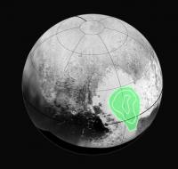
QUOTE (ZLD @ Jul 26 2015, 08:16 PM)  Here is an animation fading between the above and scalbers latest high resolution map (downscaled of course). (13MB gif) it may be just an impression, but the brightest area on the Hubble map (and your image processing) seems to match the CO-ice distribution measured by New Horizons:
|
|
|
|
|
|
|
Jul 27 2015, 02:37 AM
Post
#3
|
|
|
Member Group: Members Posts: 555 Joined: 27-September 10 Member No.: 5458 |
It looks pretty close to me as well.
I started working on it because I couldn't quite get the HST maps to line up with much on the NH maps so I took a shot in the dark, hoping I could get something to come out so I could get a better alignment. -------------------- |
|
|
|
|
Jul 27 2015, 03:20 AM
Post
#4
|
|
|
Merciless Robot Group: Admin Posts: 8785 Joined: 8-December 05 From: Los Angeles Member No.: 602 |
Very cool work.
It'd be interesting to see this tried with the Hubble Ceres imagery in order to validate & further refine your technique for other applications, but the contrast levels there aren't nearly as high as those on Pluto so it might not work nearly as well. -------------------- A few will take this knowledge and use this power of a dream realized as a force for change, an impetus for further discovery to make less ancient dreams real.
|
|
|
|
|
Jul 27 2015, 04:07 AM
Post
#5
|
|
|
Member Group: Members Posts: 555 Joined: 27-September 10 Member No.: 5458 |
It definitely works best with high contrast terrain. I have already experimented a little with Ceres with results less appealing. I'll give it another go some time though. I'm terrible at planet mapping but if someone wanted to use the HST hemispheric views to make a quick map, it would definitely make comparison a lot easier.
-------------------- |
|
|
|
|
Jul 27 2015, 04:19 AM
Post
#6
|
|
 Senior Member Group: Members Posts: 4256 Joined: 17-January 05 Member No.: 152 |
QUOTE (ZLD @ Jul 27 2015, 02:16 AM) I really just couldn't believe it. What can't you believe? There's a very crude large scale agreement between the Hubble imagery and NH, as we already know. Hubble isn't capable of resolving small-scale structure, of course. |
|
|
|
|
Jul 27 2015, 04:28 AM
Post
#7
|
|
|
Member Group: Members Posts: 555 Joined: 27-September 10 Member No.: 5458 |
There is much more agreement between the images I just posted than just large scale structures. Pick something from the processed HST image and watch it resolve on the NH map, there's a very large number of these. These weren't originally resolved and technically shouldn't be resolvable but they are there.
A good one to notice is the crater or an arc (difficult to tell) near the center right on Cthulu. Another is a curly feature on the northern rim of Tombaugh Regio. That one is really well defined. -------------------- |
|
|
|
|
Jul 27 2015, 04:50 AM
Post
#8
|
|
|
Merciless Robot Group: Admin Posts: 8785 Joined: 8-December 05 From: Los Angeles Member No.: 602 |
That probably points to the way your process is tailored more than anything else, though. As Fred pointed out, the information just isn't present in the HST images because of the resolution. By definition, you can't get sub-pixel information from a pixel since it's a uniform unit (actually a single DN, if my weak grasp of the appropriate terminology is correct).
-------------------- A few will take this knowledge and use this power of a dream realized as a force for change, an impetus for further discovery to make less ancient dreams real.
|
|
|
|
|
Jul 27 2015, 05:07 AM
Post
#9
|
|
|
Member Group: Members Posts: 555 Joined: 27-September 10 Member No.: 5458 |
To clarify again, all processing was performed on the HST image prior to alignment with the NH map. This is why I provided both, the uncorrected and the corrected views of the map for comparison. No retouching of any form is used in this. Its a mixture of lots and lots of different layering techniques and deconvolution. And again, full disclosure, I have no idea why it appears to work at all, all limitations of all involved systems considered.
-------------------- |
|
|
|
|
Jul 27 2015, 05:24 AM
Post
#10
|
||
|
Solar System Cartographer Group: Members Posts: 10226 Joined: 5-April 05 From: Canada Member No.: 227 |
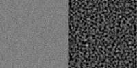
OK... ZLD, let's be absolutely clear about what you are seeing. Here is an image I just made which takes a bit of text (left), then saves it as a low quality JPG (middle - it still looks good) - but then cranks up the contrast to a ridiculous degree (right). It's now full of artifacts. That's what JPG does, that's how its algorithm works. You can't avoid it.
Your processing is very good at bringing out details that are really present in a low contrast but decently resolved image. But apply it to an image which really does not have any fine detail (like the HST images, which are greatly enlarged to make the map, maybe 8 pixels across the disk to a hundred or more across the height of the map)... and what you are 'resolving' is this JPG fuzz. There is no way any of what you are seeing in your latest image is real. It is all JPG fuzz. So keep on working with reasonably resolved images, but don't use enormously enlarged images. You are creating your own spurious detail. Phil -------------------- ... because the Solar System ain't gonna map itself.
Also to be found posting similar content on https://mastodon.social/@PhilStooke Maps for download (free PDF: https://upload.wikimedia.org/wikipedia/comm...Cartography.pdf NOTE: everything created by me which I post on UMSF is considered to be in the public domain (NOT CC, public domain) |
|
|
|
|
|
|
Jul 27 2015, 05:38 AM
Post
#11
|
|
|
Member Group: Members Posts: 555 Joined: 27-September 10 Member No.: 5458 |
Here are several highlighted features, that in my opinion, are not similar to your example and also, extremely coincidentally close to current features.

-------------------- |
|
|
|
|
Jul 27 2015, 05:55 AM
Post
#12
|
|
|
Solar System Cartographer Group: Members Posts: 10226 Joined: 5-April 05 From: Canada Member No.: 227 |
Yes,... but in the same image, 100 other points that are completely different. If you lay one complex pattern over another there will always be a few points that appear to correspond. The biggest, clearest, features in the HST image should match LORRI much better than a few faint things do, but they don't.
I'm not saying your work is useless, I'm saying this particular application of it is mistaken. Phil -------------------- ... because the Solar System ain't gonna map itself.
Also to be found posting similar content on https://mastodon.social/@PhilStooke Maps for download (free PDF: https://upload.wikimedia.org/wikipedia/comm...Cartography.pdf NOTE: everything created by me which I post on UMSF is considered to be in the public domain (NOT CC, public domain) |
|
|
|
|
Jul 27 2015, 08:53 AM
Post
#13
|
|
 Member Group: Members Posts: 238 Joined: 15-January 13 Member No.: 6842 |
QUOTE (ZLD @ Jul 27 2015, 06:07 AM) I have no idea why it appears to work at all, all limitations of all involved systems considered. Even considering what Phil said, some artificially-created features may match the real ones due to the fractal nature of the universe, i.e. the self-similarity evident at different scales. It's like taking a low-rez image of a coastline from space, using these algorithms to generate smaller detail, and then finding that many of these artificial details are similar to the real coastline details in a high-rez image. Just my 2 cents on this, after watching the excellent and eye-opening BBC documentary "The Secret Life of Chaos". -------------------- Curiosity rover panoramas: http://www.facebook.com/CuriosityRoverPanoramas
My Photosynth panoramas: http://photosynth.net/userprofilepage.aspx...;content=Synths |
|
|
|
|
Jul 27 2015, 04:03 PM
Post
#14
|
|||
|
Junior Member Group: Members Posts: 64 Joined: 17-December 12 From: Portugal Member No.: 6792 |
Left: generated noise
Right: wild processing of the generated noise
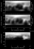
If you want to find it, a pattern always emerges. On this case, I tried to bring out "linear features" and behold they appear. I can make out a diagonal line across the top left half! If I started with a more complex image (with larger scale shadings for example) the resulting features would also be more elaborate. JPG compression artifacts, aliasing effects on scaling our even histogram manipulation will all generate noise. Just like Phil exemplified. The purpose of image processing is to remove or hide the noise, not to amplify it! To compare NH to HST, the first step it to reduce NH data to the same resolution as HST, and not the other way around. You get this (NH at bottom):
Reasonable match to the top HST map, given that the wavelengths and phase angles are different. -------------------- www.astrosurf.com/nunes
|
||
|
|
|
||
|
Jul 28 2015, 12:09 AM
Post
#15
|
|
 Senior Member Group: Members Posts: 2530 Joined: 20-April 05 Member No.: 321 |
It seems like test data is not scarce: You could print out any known image, take a photography of it from far away, and run your process on that photo, then see if you recover detail at a higher resolution than the photograph of the printout. (Of course, downsampling a digital image would seem to accomplish the same goal.)
If you want to make a double blind study of it, someone else could provide the photos, wherein you would have no possible way to obtain the photos in any other way (e.g., through Google Image Search). Roughly speaking, use the same methodology as studies of putative E.S.P. That should give you a much broader supply of test data than solar system imagery alone. |
|
|
|
|

|
Lo-Fi Version | Time is now: 22nd September 2024 - 10:39 AM |
|
RULES AND GUIDELINES Please read the Forum Rules and Guidelines before posting. IMAGE COPYRIGHT |
OPINIONS AND MODERATION Opinions expressed on UnmannedSpaceflight.com are those of the individual posters and do not necessarily reflect the opinions of UnmannedSpaceflight.com or The Planetary Society. The all-volunteer UnmannedSpaceflight.com moderation team is wholly independent of The Planetary Society. The Planetary Society has no influence over decisions made by the UnmannedSpaceflight.com moderators. |
SUPPORT THE FORUM Unmannedspaceflight.com is funded by the Planetary Society. Please consider supporting our work and many other projects by donating to the Society or becoming a member. |
|