Exploring Mt Sharp north of the dunes - Part 2: Beyond Big Sky, Site 50-51, sol 1148-1171, October 29, 2015-November 23, 2015 |

  |
Exploring Mt Sharp north of the dunes - Part 2: Beyond Big Sky, Site 50-51, sol 1148-1171, October 29, 2015-November 23, 2015 |
 Nov 10 2015, 01:08 PM Nov 10 2015, 01:08 PM
Post
#46
|
||
|
Senior Member  Group: Members Posts: 2346 Joined: 7-December 12 Member No.: 6780 |
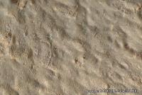
QUOTE (PaulH51 @ Nov 9 2015, 12:29 PM)  Some very interesting long/thin structures in this close-up MAHLI of Augusta. Anyone here got any suggestions as to what these structures could be? Scratches caused by the DRT. Here a crop of a 90° rotated version, to reduce optical illusion of raised features:
It's pointing towards the rock being soft. Maybe they've changed the method of brushing to avoid "micro-drillholes" and twisting of the bristles, meaning they may move the DRT during brushing. |
|
 |
 
|
|
|
Nov 10 2015, 10:54 PM
Post
#47
|
|
 Senior Member Group: Members Posts: 2430 Joined: 30-January 13 From: Penang, Malaysia. Member No.: 6853 |
QUOTE (Gerald @ Nov 10 2015, 09:08 PM) Scratches caused by the DRT. Here a crop of a 90° rotated version, to reduce optical illusion of raised features: It's pointing towards the rock being soft. Maybe they've changed the method of brushing to avoid "micro-drillholes" and twisting of the bristles, meaning they may move the DRT during brushing. Thanks Gerald, your rotated image allowed me to see they are grooves and not raised, which was my first impression. |
|
|
|
|
Nov 12 2015, 07:16 AM
Post
#48
|
|
|
Senior Member Group: Members Posts: 2430 Joined: 30-January 13 From: Penang, Malaysia. Member No.: 6853 |
Something unusual with the supply of engineering raw images for the drive on sol 1160? There are some images the were acquired before the drive started, and we even have a new JPL location map showing the path and post drive location,
 Not sure when we will be able to see those Buttes in the rovers images, but they sure will be a welcome sight... Not sure when we will be able to see those Buttes in the rovers images, but they sure will be a welcome sight... EDIT: JSON now reflects the status of all the available images. |
|
|
|
|
Nov 13 2015, 04:29 AM
Post
#49
|
|
|
Senior Member Group: Members Posts: 2430 Joined: 30-January 13 From: Penang, Malaysia. Member No.: 6853 |
Another Drive Planned : Mission Update: Sols 1162-1163: Approaching Bagnold Dunes by Ken Herkenhoff LINK
QUOTE Today is a holiday for some of us, but not the MSL tactical operations team! The 55-meter drive planned for Sol 1160 completed as planned, and another 41-meter drive is planned for Sol 1162. Before the next drive, Mastcam and ChemCam will observe a small, sandy drift named "Arris" and a bedrock target dubbed "Tsumeb." Mastcam will also acquire two mosaics, one of nearby outcrops and one of more distant rocks. The drive should place the rover between two of the Bagnold Dunes, so the vehicle will turn to a heading that will maximize the chances of acquiring good REMS measurements of wind speed and direction. This observation is part of the dune study campaign that has been developed over the past year, with an overall goal of better understanding how winds on Mars form and modify dunes. Observations of the dunes from orbit show that they are active, so many members of the MSL science team are looking forward to detailed measurements of the winds and their effects on the sand dunes and nearby terrain, as winds are currently the most significant agent of erosion on Mars. On Sol 1163, Mastcam will take pictures of the rover deck to allow tracking of changes in the distribution of dust and sand on the top of the vehicle, and image the sun to measure the amount of dust in the atmosphere. Navcam will also observe the sky and search for dust devils.
|
|
|
|
|
Nov 13 2015, 06:15 AM
Post
#50
|
|
|
Senior Member Group: Members Posts: 2430 Joined: 30-January 13 From: Penang, Malaysia. Member No.: 6853 |
|
|
|
|
|
Nov 13 2015, 01:14 PM
Post
#51
|
||
|
Senior Member Group: Members Posts: 2430 Joined: 30-January 13 From: Penang, Malaysia. Member No.: 6853 |
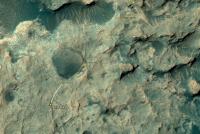
Joe Knapp's MSL drive page is showing the planned drive today (sol 1162) was completed, his location map needs adjusting, but we can use the path on his page to provide a rough estimate the new location after the drive which I have transposed onto JPL's sol 1160 location map. Posted here to reduce the signal to noise ratio on the MSL location thread. I'd rather have the engineering images, but once again we have another day without any...

|
|
|
|
|
|
|
Nov 14 2015, 03:14 AM
Post
#52
|
|
|
Senior Member Group: Members Posts: 2430 Joined: 30-January 13 From: Penang, Malaysia. Member No.: 6853 |
Mission Update from Ken Herkenhoff - Sols 1164-1165: Brushing "Swartkloofberg" LINK
QUOTE The rover drove over 38 meters on Sol 1162, as expected. We are transitioning out of restricted planning, so only 2 sols are being planned for this weekend. There were so many good ideas for activities this morning that the team had to decide which to remove from the plan to leave enough charge in the rover's batteries to enable nominal planning on Monday. Still, the plan is a very full one: On Sol 1164, ChemCam and Mastcam will observe one of the Bagnold Dunes that is a near-term goal for detailed investigation, plus other more nearby targets called "Swakop" and "Zaris." After another AEGIS checkout activity, the arm will be deployed to take a MAHLI image of the REMS UV sensor and of a rock dubbed "Swartkloofberg." Then the DRT will brush the dust off Swartkloofberg and MAHLI will acquire mosaics of the brushed spot and of Swakop before the APXS is placed on the brushed spot for an overnight integration. On Sol 1165, the arm will be stowed and the rover will drive farther south, again orienting the vehicle for REMS wind measurements. After sunset, SAM will clean its scrubbers, an engineering activity that has been performed twice before. Finally, the rover will go to sleep and recharge in preparation for the next sol's activities.
|
|
|
|
|
Nov 14 2015, 09:21 AM
Post
#53
|
|
|
Senior Member Group: Members Posts: 2430 Joined: 30-January 13 From: Penang, Malaysia. Member No.: 6853 |
|
|
|
|
|
Nov 14 2015, 10:15 AM
Post
#54
|
|
|
Senior Member Group: Members Posts: 2430 Joined: 30-January 13 From: Penang, Malaysia. Member No.: 6853 |
|
|
|
|
|
Nov 14 2015, 11:14 PM
Post
#55
|
|
|
Senior Member Group: Members Posts: 2430 Joined: 30-January 13 From: Penang, Malaysia. Member No.: 6853 |
Interesting jump / spike in the reported air pressure (Pa) from REMS
1161 = 1200 1160 = 1177 1159 = 898 1158 = 898 1157 = 900 1156 = 900 1155 = 900 1154 = 900 1153 = 900 1152 = 901 1151 = 901 We saw a single spike of 1150 Pa in Joe's REMS pressure chart that covered the first 740 sols... Probably just another spike, but will check the new data when its available
|
|
|
|
|
Nov 15 2015, 07:11 PM
Post
#56
|
|
|
Senior Member Group: Members Posts: 2346 Joined: 7-December 12 Member No.: 6780 |
The pressure jump doesn't look physical.
Calibrating and interpreting REMS data is far from trivial. Exposure to sun, or shadowing, a moving mast, warm-up, etc. may modify the raw data. For calibration, e.g. splines are used; switch from one polynomial to another may modify the interpretation. It's not quite clear, which effects have been considered for the implementation of the REMS website, and what's the default strategy in case of invalid data. Careful interpretation of the REMS PDS releases will eventually resolve the effect. |
|
|
|
|
Nov 16 2015, 01:38 AM
Post
#57
|
|
|
Senior Member Group: Members Posts: 2430 Joined: 30-January 13 From: Penang, Malaysia. Member No.: 6853 |
QUOTE (Gerald @ Nov 16 2015, 03:11 AM) The pressure jump doesn't look physical. I have to agree, it looked too high a jump to be 'real'. I only reported it here as it was elevated over two consecutive sols. And it will be many months before we have access to the PDS data. The REMS page has yet to update (after their usual weekend break), I will check later to see if the raw data trend continues, or if it returns back to the seasonal norms. |
|
|
|
|
Nov 16 2015, 08:07 AM
Post
#58
|
|
|
Senior Member Group: Members Posts: 2430 Joined: 30-January 13 From: Penang, Malaysia. Member No.: 6853 |
|
|
|
|
|
Nov 16 2015, 01:15 PM
Post
#59
|
|
|
Senior Member Group: Members Posts: 2430 Joined: 30-January 13 From: Penang, Malaysia. Member No.: 6853 |
Does anyone here know why the public release of Curiosity's engineering images as dried up?
As if that was not something to cause withdrawal symptoms, the sol 1151 mast cam images that have just been released are Bayer Encoded |
|
|
|
|
Nov 16 2015, 03:35 PM
Post
#60
|
|
|
Solar System Cartographer Group: Members Posts: 10189 Joined: 5-April 05 From: Canada Member No.: 227 |
Yes... I hope it will be fixed soon. At least we are not losing everything.
Phil -------------------- ... because the Solar System ain't gonna map itself.
Also to be found posting similar content on https://mastodon.social/@PhilStooke Maps for download (free PD: https://upload.wikimedia.org/wikipedia/comm...Cartography.pdf NOTE: everything created by me which I post on UMSF is considered to be in the public domain (NOT CC, public domain) |
|
|
|
|

|
Lo-Fi Version | Time is now: 7th June 2024 - 06:05 AM |
|
RULES AND GUIDELINES Please read the Forum Rules and Guidelines before posting. IMAGE COPYRIGHT |
OPINIONS AND MODERATION Opinions expressed on UnmannedSpaceflight.com are those of the individual posters and do not necessarily reflect the opinions of UnmannedSpaceflight.com or The Planetary Society. The all-volunteer UnmannedSpaceflight.com moderation team is wholly independent of The Planetary Society. The Planetary Society has no influence over decisions made by the UnmannedSpaceflight.com moderators. |
SUPPORT THE FORUM Unmannedspaceflight.com is funded by the Planetary Society. Please consider supporting our work and many other projects by donating to the Society or becoming a member. |
|