Exploring Mt Sharp north of the dunes - Part 2: Beyond Big Sky, Site 50-51, sol 1148-1171, October 29, 2015-November 23, 2015 |

  |
Exploring Mt Sharp north of the dunes - Part 2: Beyond Big Sky, Site 50-51, sol 1148-1171, October 29, 2015-November 23, 2015 |
 Nov 18 2015, 07:55 PM Nov 18 2015, 07:55 PM
Post
#76
|
|
|
Member  Group: Members Posts: 306 Joined: 4-October 14 Member No.: 7273 |
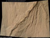
Sol 1158 postcard, looking out over Brandenburg
 Curiosity - Sol 1158 by Justin Cowart, on Flickr Sol 1155 postcard, looking at Cut Bank Valley.  Sol 1155 Postcard by Justin Cowart, on Flickr |
 |
 
|
|
Nov 19 2015, 10:13 AM
Post
#77
|
||
 Senior Member Group: Members Posts: 2429 Joined: 30-January 13 From: Penang, Malaysia. Member No.: 6853 |
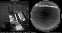
Before its drive on 1167, curiosity used its RMI to target Bagnald Dune #1, using the pointing data I think I may have located the target area on a 1162 NavCam frame.
Raw NavCam LINK Raw RMI LINK Another planned drive completed on Sol 1168 closer to the dunes, images still coming in.... Mission Update from Lauren Edgar - Sols 1167-1168: Onward to the Bagnold Dunes LINK QUOTE The Bagnold Dunes are tantalizingly close, and this week is mostly focused on driving to the dunes. On Sol 1167 Curiosity drove 39 m, and the dunes are starting to look pretty big, as seen in the above Navcam image. For more on our plans when we get to the dunes, check out this recent press release.
The plan today looks very similar to yesterday, with a pre-drive science block, a drive, and post-drive imaging. Science activities include Mastcam and ChemCam observations of the local bedrock at a target named Etosha, as well as Mastcam deck monitoring to look for fine sand that might accumulate as we approach the active dunes. After the drive well acquire standard imaging to prepare for future targeting and terrain assessment. Were also planning a SAM atmospheric observation to look for methane, exactly one Mars year after the previous high detections.... |
|
|
|
|
|
|
Nov 19 2015, 04:40 PM
Post
#78
|
||
|
Solar System Cartographer Group: Members Posts: 10173 Joined: 5-April 05 From: Canada Member No.: 227 |
Reprojecting the sol 1168 Hazcams helps to locate us:
Phil -------------------- ... because the Solar System ain't gonna map itself.
Also to be found posting similar content on https://mastodon.social/@PhilStooke Maps for download (free PD: https://upload.wikimedia.org/wikipedia/comm...Cartography.pdf NOTE: everything created by me which I post on UMSF is considered to be in the public domain (NOT CC, public domain) |
|
|
|
|
|
|
Nov 19 2015, 09:34 PM
Post
#79
|
|||
|
Member Group: Members Posts: 866 Joined: 15-March 05 From: Santa Cruz, CA Member No.: 196 |
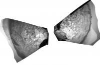
a couple of stereograms (parellel) from sol1168 to try to get a sense of topography of Dune 1 leading edge at Curiosity left and the 'other dune trailing edge (on right)
|
||
|
|
|
||
|
Nov 20 2015, 06:47 AM
Post
#80
|
|
|
Senior Member Group: Members Posts: 2429 Joined: 30-January 13 From: Penang, Malaysia. Member No.: 6853 |
|
|
|
|
|
Nov 20 2015, 09:39 AM
Post
#81
|
||
|
Senior Member Group: Members Posts: 2837 Joined: 22-April 05 From: Ridderkerk, Netherlands Member No.: 353 |
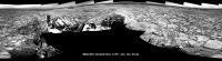
The Navcam L panoramic view on Sol 1167.
Jan van Driel
|
|
|
|
|
|
|
Nov 20 2015, 09:55 AM
Post
#82
|
|
|
Senior Member Group: Members Posts: 2429 Joined: 30-January 13 From: Penang, Malaysia. Member No.: 6853 |
|
|
|
|
|
Nov 20 2015, 12:35 PM
Post
#83
|
||
|
Senior Member Group: Members Posts: 2837 Joined: 22-April 05 From: Ridderkerk, Netherlands Member No.: 353 |
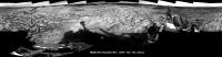
and the Panoramic view on Sol 1168.
Jan van Driel
|
|
|
|
|
|
|
Nov 20 2015, 04:51 PM
Post
#84
|
||
|
Solar System Cartographer Group: Members Posts: 10173 Joined: 5-April 05 From: Canada Member No.: 227 |
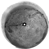
And this is the sol 1168 panorama in circular form. But for a change, it is not from Jan's panorama. Emily had tweeted a link to Damia Bouic's higher resolution version of the panorama:
http://www.db-prods.net/marsroversimages/c...y-2014.html#107 ... so I used that. The higher resolution really helps the distant part of the scene remain sharp during reprojection. Dear Damia, if you read this, I hope we will see you here again, especially as the scenery is getting better all the time. And we need a beam of light to help overcome the dark clouds which too often hide the sun!
-------------------- ... because the Solar System ain't gonna map itself.
Also to be found posting similar content on https://mastodon.social/@PhilStooke Maps for download (free PD: https://upload.wikimedia.org/wikipedia/comm...Cartography.pdf NOTE: everything created by me which I post on UMSF is considered to be in the public domain (NOT CC, public domain) |
|
|
|
|
|
|
Nov 20 2015, 05:02 PM
Post
#85
|
||
|
Solar System Cartographer Group: Members Posts: 10173 Joined: 5-April 05 From: Canada Member No.: 227 |
And Jan's pan for sol 1167 gets the same treatment.
Phil
-------------------- ... because the Solar System ain't gonna map itself.
Also to be found posting similar content on https://mastodon.social/@PhilStooke Maps for download (free PD: https://upload.wikimedia.org/wikipedia/comm...Cartography.pdf NOTE: everything created by me which I post on UMSF is considered to be in the public domain (NOT CC, public domain) |
|
|
|
|
|
|
Nov 20 2015, 07:53 PM
Post
#86
|
|
 Member Group: Members Posts: 334 Joined: 11-December 12 From: The home of Corby Crater (Corby-England) Member No.: 6783 |
Well said.
|
|
|
|
|
Nov 20 2015, 09:12 PM
Post
#87
|
|
|
Member Group: Members Posts: 866 Joined: 15-March 05 From: Santa Cruz, CA Member No.: 196 |
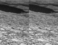
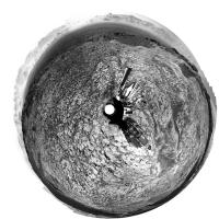
exceptionally bright vein segment sol1168 navcam and mastcam.
just a chance specular angle or did we break that rock? i dont see the usual track scrapes but some smooshed sand bulges at the foot of rocks and a couple bits and pieces are lying about also, nice little windtails on the pebbles to the right.. |
|
|
|
|
Nov 21 2015, 01:36 AM
Post
#88
|
|
|
Senior Member Group: Members Posts: 2429 Joined: 30-January 13 From: Penang, Malaysia. Member No.: 6853 |
Mission Update from Lauren Edgar - Sols 1170-1172: Studying bedrock, sand, and sky. LINK
QUOTE This week Curiosity has been driving towards the Bagnold Dunes and characterizing the bedrock and sand along the way. After a successful SAM methane experiment and 36.5 m drive on Sol 1168, Curiosity spent Sol 1169 recharging and assessing some of the local bedrock and dunes.
The weekend 3-sol plan starts with a number of environmental monitoring activities to assess atmospheric opacity and composition. The second sol includes several ChemCam and Mastcam activities to study the local bedrock and prepare for the upcoming dune investigation. Well also use Navcam to search for dust devils and monitor clouds and wind, and to monitor the deck of the rover to look for dust and sand accumulation. On the third sol well drive and take our standard post-drive imaging. The plan also includes SAM and CheMin activities for prepare for future sampling. Ill be on duty next week, so Ive been monitoring the weekend activities and getting ready for some exciting observations next week. |
|
|
|
|
Nov 21 2015, 08:14 AM
Post
#89
|
|
|
Senior Member Group: Members Posts: 2429 Joined: 30-January 13 From: Penang, Malaysia. Member No.: 6853 |
|
|
|
|
|
Nov 21 2015, 01:06 PM
Post
#90
|
||
|
Senior Member Group: Members Posts: 2837 Joined: 22-April 05 From: Ridderkerk, Netherlands Member No.: 353 |
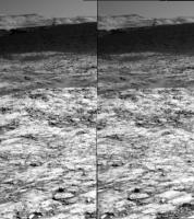
Nice Navcam L view on Sol 1169.
Jan van Driel
|
|
|
|
|
|
|

|
Lo-Fi Version | Time is now: 1st June 2024 - 02:19 PM |
|
RULES AND GUIDELINES Please read the Forum Rules and Guidelines before posting. IMAGE COPYRIGHT |
OPINIONS AND MODERATION Opinions expressed on UnmannedSpaceflight.com are those of the individual posters and do not necessarily reflect the opinions of UnmannedSpaceflight.com or The Planetary Society. The all-volunteer UnmannedSpaceflight.com moderation team is wholly independent of The Planetary Society. The Planetary Society has no influence over decisions made by the UnmannedSpaceflight.com moderators. |
SUPPORT THE FORUM Unmannedspaceflight.com is funded by the Planetary Society. Please consider supporting our work and many other projects by donating to the Society or becoming a member. |
|