Exploring Mt Sharp north of the dunes - Part 2: Beyond Big Sky, Site 50-51, sol 1148-1171, October 29, 2015-November 23, 2015 |

  |
Exploring Mt Sharp north of the dunes - Part 2: Beyond Big Sky, Site 50-51, sol 1148-1171, October 29, 2015-November 23, 2015 |
 Nov 21 2015, 05:25 PM Nov 21 2015, 05:25 PM
Post
#91
|
|
|
Senior Member  Group: Members Posts: 2090 Joined: 13-February 10 From: Ontario Member No.: 5221 |
Memories of El Dorado at Gusev... Will Curiosity be actually able to measure their movement on the ground, some sort of time-lapse measurements at the edges, maybe?
|
 |
 
|
|
Nov 21 2015, 05:42 PM
Post
#92
|
|
|
Solar System Cartographer Group: Members Posts: 10189 Joined: 5-April 05 From: Canada Member No.: 227 |
Almost certainly the rover would not be in one place long enough to see any movement of the dune. But it might be feasible to take high resolution MAHLI images showing individual grains several times over a few sols and get an estimate of the number of moving grains per square meter per sol, and relate it to wind speed.
Phil -------------------- ... because the Solar System ain't gonna map itself.
Also to be found posting similar content on https://mastodon.social/@PhilStooke Maps for download (free PD: https://upload.wikimedia.org/wikipedia/comm...Cartography.pdf NOTE: everything created by me which I post on UMSF is considered to be in the public domain (NOT CC, public domain) |
|
|
|
|
Nov 21 2015, 06:30 PM
Post
#93
|
|
 Senior Member Group: Members Posts: 4252 Joined: 17-January 05 Member No.: 152 |
The movement is on the order of 1 m/yr, or 1 cm per few days, so conceivably we might see some changes at the edges. Of course that will depend on how well-defined (ie how sharp) those edges are. More importantly, it'll depend on how uniform that movement is over the Martian year. Most of the movement might happen in a relatively short interval, such as during the summer dust storm season, in which case we might be out of luck.
|
|
|
|
|
Nov 21 2015, 10:19 PM
Post
#94
|
|
|
Senior Member Group: Members Posts: 1045 Joined: 17-February 09 Member No.: 4605 |
Well Curiosity's ability to determine wind direction may be constrained, but in this area at least they will be able to correlate wind direction and velocity.
|
|
|
|
|
Nov 22 2015, 01:52 PM
Post
#95
|
||
|
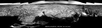
Senior Member Group: Members Posts: 2837 Joined: 22-April 05 From: Ridderkerk, Netherlands Member No.: 353 |
The Navcam L images taken on Sol 1168 and Sol 1169 stitched together.
Jan van Driel
|
|
|
|
|
|
|
Nov 23 2015, 03:32 AM
Post
#96
|
|
 Senior Member Group: Members Posts: 2430 Joined: 30-January 13 From: Penang, Malaysia. Member No.: 6853 |
1158 L-MastCam, 27x1 preview of the 360 degree panorama (MS ICE and processed) Some exposure issues at the overlaps on the RH side
 Flickr Original Size 29184 x 1374 pixels LINK No Imgur mirror link (failed to UL properly) |
|
|
|
|
Nov 23 2015, 10:28 AM
Post
#97
|
|
|
Member Group: Members Posts: 362 Joined: 13-April 06 From: Malta Member No.: 741 |
I note that it was mentioned that the study of the upcoming Bagnold dune field is the first attempt of its sort with regards to Mars exploration. I recall the El Dorado dune at the Spirit landing sight in Colombia Hills . Is that a completely different structure or something similar?
|
|
|
|
|
Nov 23 2015, 11:53 AM
Post
#98
|
|
|
Senior Member Group: Members Posts: 2430 Joined: 30-January 13 From: Penang, Malaysia. Member No.: 6853 |
Just for fun.... The Bagnold Dunes: EDL to Sol 1171, Using browse MARDI images from the Analyst's Notebook and a revised JPL location map. I have annotated the approximate location of Bradbury Landing and sol 1172 onto the lower middle MARDI Frame.
 Flickr Original Size 6324 x 3066 pixels LINK Imgur mirror LINK |
|
|
|
|
Nov 23 2015, 03:55 PM
Post
#99
|
|
 Member Group: Members Posts: 244 Joined: 2-March 15 Member No.: 7408 |
|
|
|
|
|
Nov 23 2015, 07:36 PM
Post
#100
|
|
|
Junior Member Group: Members Posts: 41 Joined: 27-May 09 From: Burgundy Member No.: 4798 |
QUOTE (climber @ Nov 9 2015, 12:54 PM)  Do We have a meteorite (black rock) at 10h30 approx ? Effectively, it looks like an iron meteorite (sol1158). Sadly far away now. |
|
|
|
|
Nov 23 2015, 09:55 PM
Post
#101
|
|
|
Member Group: Members Posts: 866 Joined: 15-March 05 From: Santa Cruz, CA Member No.: 196 |
QUOTE (Bill @ Nov 23 2015, 11:36 AM) Effectively, it looks like an iron meteorite (sol1158). Sadly far away now. If that rock at 10h30 is the one from sol1158 mastcam or navcam, it looks like run of the mill crater ejecta to my untrained eye at least. |
|
|
|
|
Nov 24 2015, 01:15 AM
Post
#102
|
|
|
Senior Member Group: Members Posts: 2430 Joined: 30-January 13 From: Penang, Malaysia. Member No.: 6853 |
|
|
|
|
|
Nov 24 2015, 02:01 PM
Post
#103
|
||
 Junior Member Group: Members Posts: 43 Joined: 14-December 12 Member No.: 6784 |
Haven't seen this here before so thought I'd share Sol 1157 [12615x2102].
Lossless upload via Theory Send: http://theorysend.com/uploads/4f5e017c229e...2f6da6c52b8389a Very lossy upload via Imgur: http://i.imgur.com/wcViqEx.jpg (do not recommend  ) ) 25% size thumbnail attached.
Attached thumbnail(s)
|
|
|
|
|
|
|
Nov 26 2015, 08:45 AM
Post
#104
|
|
 Senior Member Group: Moderator Posts: 2262 Joined: 9-February 04 From: Melbourne - Oz Member No.: 16 |
We have arrived at the dunes, so time for a new thread.
Exploring Mt Sharp - The Dunes - Part 1: Bagnold Dunes, Site 51-, Sol 1172-, November 24, 2015-... -------------------- |
|
|
|
|
Nov 28 2015, 07:00 AM
Post
#105
|
|
|
Senior Member Group: Members Posts: 2430 Joined: 30-January 13 From: Penang, Malaysia. Member No.: 6853 |
|
|
|
|
|

|
Lo-Fi Version | Time is now: 7th June 2024 - 09:35 AM |
|
RULES AND GUIDELINES Please read the Forum Rules and Guidelines before posting. IMAGE COPYRIGHT |
OPINIONS AND MODERATION Opinions expressed on UnmannedSpaceflight.com are those of the individual posters and do not necessarily reflect the opinions of UnmannedSpaceflight.com or The Planetary Society. The all-volunteer UnmannedSpaceflight.com moderation team is wholly independent of The Planetary Society. The Planetary Society has no influence over decisions made by the UnmannedSpaceflight.com moderators. |
SUPPORT THE FORUM Unmannedspaceflight.com is funded by the Planetary Society. Please consider supporting our work and many other projects by donating to the Society or becoming a member. |
|