South to Vera Rubin Ridge, (Sites 62-63, Sols 1659-1726, Apr 6 2017-Jun 14 2017) |

  |
South to Vera Rubin Ridge, (Sites 62-63, Sols 1659-1726, Apr 6 2017-Jun 14 2017) |
 May 5 2017, 10:26 AM May 5 2017, 10:26 AM
Post
#76
|
||
|
Senior Member  Group: Members Posts: 2836 Joined: 22-April 05 From: Ridderkerk, Netherlands Member No.: 353 |
The Navcam L view on Sol 1686.
Jan van Driel
|
|
 |
 
|
|
|
May 5 2017, 01:28 PM
Post
#77
|
|
 Junior Member Group: Members Posts: 21 Joined: 21-August 12 From: the Netherlands Member No.: 6599 |
Thanks 4 the great pictures Jan, Paul, Phil, atom et al.
-------------------- ---------------------------------------------------------- Gale is a Crater filled by Volcano M.Sharp ----------------------------------------------------------- |
|
|
|
|
May 5 2017, 02:03 PM
Post
#78
|
|
|
Member Group: Members Posts: 122 Joined: 19-June 07 Member No.: 2455 |
I see that we're ascending a hill because the view of the base of Mt. Sharp is really obstructed and has been for awhile. How much more distance do we have to go before we crest this rise?
|
|
|
|
|
May 5 2017, 06:57 PM
Post
#79
|
||
|
Solar System Cartographer Group: Members Posts: 10173 Joined: 5-April 05 From: Canada Member No.: 227 |
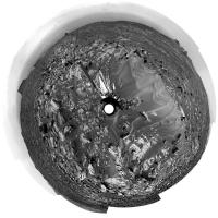
Jan's sol 1686 panorama in circular form. Compare with the previous one to see how we moved down the SW side of the linear megaripple.
Phil
-------------------- ... because the Solar System ain't gonna map itself.
Also to be found posting similar content on https://mastodon.social/@PhilStooke Maps for download (free PD: https://upload.wikimedia.org/wikipedia/comm...Cartography.pdf NOTE: everything created by me which I post on UMSF is considered to be in the public domain (NOT CC, public domain) |
|
|
|
|
|
|
May 5 2017, 09:59 PM
Post
#80
|
|
 Senior Member Group: Members Posts: 1641 Joined: 5-March 05 From: Boulder, CO Member No.: 184 |
QUOTE (Art Martin @ May 5 2017, 02:03 PM)  I see that we're ascending a hill because the view of the base of Mt. Sharp is really obstructed and has been for awhile. How much more distance do we have to go before we crest this rise? It seems most of the rest of the mission will be on a similar slope up Mt. Sharp. -------------------- Steve [ my home page and planetary maps page ]
|
|
|
|
|
May 6 2017, 03:13 AM
Post
#81
|
||
 Senior Member Group: Members Posts: 2429 Joined: 30-January 13 From: Penang, Malaysia. Member No.: 6853 |
QUOTE (Art Martin @ May 5 2017, 10:03 PM) I see that we're ascending..... This may help Note the vertical dimension is exaggerated 14-fold... Full report Link
|
|
|
|
|
|
|
May 6 2017, 11:17 PM
Post
#82
|
|
|
Member Group: Members Posts: 122 Joined: 19-June 07 Member No.: 2455 |
QUOTE (PaulH51 @ May 5 2017, 08:13 PM) This may help Thank you. Wow, the views should be spectacular. |
|
|
|
|
May 7 2017, 12:38 AM
Post
#83
|
|
|
Member Group: Members Posts: 122 Joined: 19-June 07 Member No.: 2455 |
Some 3D from Sol 1686
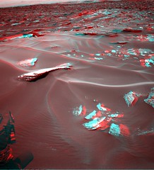 1686 Ripples Anaglyph 2 1686 Ripples Anaglyph 2 1686 Ripples Side By Side 2 1686 Ripples Side By Side 2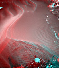 1686 Ripples Anaglyph 1686 Ripples Anaglyph 1686 Ripples Side By Side 1686 Ripples Side By Side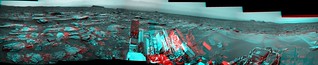 Panorama Anaglyph by Art Martin, on Flickr Panorama Anaglyph by Art Martin, on Flickr
|
|
|
|
|
May 7 2017, 02:24 AM
Post
#84
|
||
|
Senior Member Group: Members Posts: 2429 Joined: 30-January 13 From: Penang, Malaysia. Member No.: 6853 |
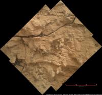
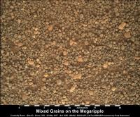
Sol 1682 : A mosaic of focus merged MAHLIs assembled in MS ICE (the base images were acquired one sol earlier)
Scale from focus motor count using Gerald's MAHLI Ruler
|
|
|
|
|
|
|
May 7 2017, 10:42 AM
Post
#85
|
|
|
Senior Member Group: Members Posts: 2429 Joined: 30-January 13 From: Penang, Malaysia. Member No.: 6853 |
|
|
|
|
|
May 8 2017, 03:17 AM
Post
#86
|
||
|
Senior Member Group: Members Posts: 2429 Joined: 30-January 13 From: Penang, Malaysia. Member No.: 6853 |
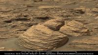
Sol 1688: a crop from a mosaic of two R-MastCam frames looking WSW of the rover. Assembled in MS ICE, scale bar added using AlgorimancerPG which placed the large block at ~15 m from the camera, contrast stretched.
|
|
|
|
|
|
|
May 8 2017, 10:11 AM
Post
#87
|
|
|
Senior Member Group: Members Posts: 1074 Joined: 21-September 07 From: Québec, Canada Member No.: 3908 |
The complete sol 1688 Rmastcam panorama:
|
|
|
|
|
May 9 2017, 12:52 AM
Post
#88
|
||
|
Senior Member Group: Members Posts: 2429 Joined: 30-January 13 From: Penang, Malaysia. Member No.: 6853 |
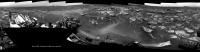
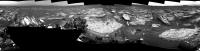
1690 L-NavCam: Quick & very dirty in MS ICE, but it's a full 360 and may suffice until Jan can do his magic. We appear to have the right rear wheel close to the small outcrop featured in my last post, Edit JPL show the drive to be a tad over 11 meters. We have now reached site 63
 50% preview and link (below) to the full resolution pan on Imgur
Full resolution pan LINK |
|
|
|
|
|
|
May 9 2017, 01:27 AM
Post
#89
|
||
|
Solar System Cartographer Group: Members Posts: 10173 Joined: 5-April 05 From: Canada Member No.: 227 |
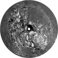
Paul's panorama in a circular version - I cropped out the horizon, which had a few defects in it that are magnified by my reprojection method.
Phil
-------------------- ... because the Solar System ain't gonna map itself.
Also to be found posting similar content on https://mastodon.social/@PhilStooke Maps for download (free PD: https://upload.wikimedia.org/wikipedia/comm...Cartography.pdf NOTE: everything created by me which I post on UMSF is considered to be in the public domain (NOT CC, public domain) |
|
|
|
|
|
|
May 9 2017, 04:56 PM
Post
#90
|
||
|
Senior Member Group: Members Posts: 2836 Joined: 22-April 05 From: Ridderkerk, Netherlands Member No.: 353 |
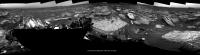
The Navcam L view on Sol 1690.
Jan van Driel
|
|
|
|
|
|
|

|
Lo-Fi Version | Time is now: 31st May 2024 - 05:10 PM |
|
RULES AND GUIDELINES Please read the Forum Rules and Guidelines before posting. IMAGE COPYRIGHT |
OPINIONS AND MODERATION Opinions expressed on UnmannedSpaceflight.com are those of the individual posters and do not necessarily reflect the opinions of UnmannedSpaceflight.com or The Planetary Society. The all-volunteer UnmannedSpaceflight.com moderation team is wholly independent of The Planetary Society. The Planetary Society has no influence over decisions made by the UnmannedSpaceflight.com moderators. |
SUPPORT THE FORUM Unmannedspaceflight.com is funded by the Planetary Society. Please consider supporting our work and many other projects by donating to the Society or becoming a member. |
|