SpaceIL lunar lander mission - 2019 |

  |
SpaceIL lunar lander mission - 2019 |
 Sep 13 2018, 06:21 AM Sep 13 2018, 06:21 AM
Post
#1
|
|
|
Solar System Cartographer  Group: Members Posts: 10227 Joined: 5-April 05 From: Canada Member No.: 227 |
I'm setting this up in preparation for the launch of SpaceIL's lunar mission, probably early next year. They have arranged a rideshare with Spaceflight Industries on a Falcon 9 launch early in 2019. Earlier they were saying launch in December, land on the Moon in February, so now I assume the landing might be delayed until March. This mission was originally going to be part of the Google Lunar X Prize, but that of course is now gone. It might be rekindled with a different sponsor (though I doubt it).
SpaceIL is the first of the GLXP teams to actually make it to a launch. For what it's worth, I expect Astrobotic to fly as well, and I think Team Indus and PTScientists may also get off the ground. I'm hearing things about Moon Express which cause me to doubt its chances. More on landing sites shortly. Phil -------------------- ... because the Solar System ain't gonna map itself.
Also to be found posting similar content on https://mastodon.social/@PhilStooke Maps for download (free PDF: https://upload.wikimedia.org/wikipedia/comm...Cartography.pdf NOTE: everything created by me which I post on UMSF is considered to be in the public domain (NOT CC, public domain) |
 |
 
|
|
Sep 13 2018, 07:09 PM
Post
#2
|
|
|
Solar System Cartographer Group: Members Posts: 10227 Joined: 5-April 05 From: Canada Member No.: 227 |
The lander will carry a magnetometer, and landing site discussions have suggested landing at a magnetic anomaly. Early talk about this suggested landing at the well-known Reiner Gamma swirl and magnetic anomaly in Oceanus Procellarum, probably the best known such feature on the Moon. This was illustrated in a Youtube video:
https://www.youtube.com/watch?v=VRJ5HsgHhxQ Subsequent work changed the target. Areas within about 20 degrees of the limb were off limits to avoid communication problems, and areas within about --- degrees of the equator were rejected for thermal reasons (to avoid the hottest temperatures at lunar noon). Within the northern and southern zones remaining, topographically safe sites were selected, avoiding regions with particularly low or high albedo to facilitate use of the laser altimeter. Those sites were compared with maps of magnetic anomalies and three potential sites were selected. This process is described in a 2017 LPSC abstract and poster: LPSC abstract, 2017: https://www.hou.usra.edu/meetings/lpsc2017/pdf/1914.pdf associated poster: https://www.researchgate.net/publication/32...ion_to_the_Moon (I spoke to Grossman at the meeting). The favoured site was near Berzelius crater. I will show a map later. Phil -------------------- ... because the Solar System ain't gonna map itself.
Also to be found posting similar content on https://mastodon.social/@PhilStooke Maps for download (free PDF: https://upload.wikimedia.org/wikipedia/comm...Cartography.pdf NOTE: everything created by me which I post on UMSF is considered to be in the public domain (NOT CC, public domain) |
|
|
|
|
Sep 23 2018, 05:49 PM
Post
#3
|
||
|
Solar System Cartographer Group: Members Posts: 10227 Joined: 5-April 05 From: Canada Member No.: 227 |
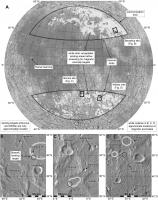
This illustration shows the sites suggested for SpaceIL in the abstract and poster mentioned above.
The company which built the lander for SpaceIL is contemplating the possibility of future missions: https://spacenews.com/iai-studying-follow-o...l-lunar-lander/ Phil -------------------- ... because the Solar System ain't gonna map itself.
Also to be found posting similar content on https://mastodon.social/@PhilStooke Maps for download (free PDF: https://upload.wikimedia.org/wikipedia/comm...Cartography.pdf NOTE: everything created by me which I post on UMSF is considered to be in the public domain (NOT CC, public domain) |
|
|
|
|
|
|
Sep 24 2018, 03:48 AM
Post
#4
|
|
|
Merciless Robot Group: Admin Posts: 8785 Joined: 8-December 05 From: Los Angeles Member No.: 602 |
Interesting. Kinda makes me wonder if they're actually interested in finding ferrous metal deposits, presumably left by iron-nickel impactors.
-------------------- A few will take this knowledge and use this power of a dream realized as a force for change, an impetus for further discovery to make less ancient dreams real.
|
|
|
|
|
Oct 30 2018, 11:46 PM
Post
#5
|
|
|
Solar System Cartographer Group: Members Posts: 10227 Joined: 5-April 05 From: Canada Member No.: 227 |
SpaceIL has been running a lander name competition - I didn't know about it, but it looks like it ran on their Facebook page and they got lots of suggestions, then made a shortlist and are now asking the public to vote on names from the shortlist.
https://twitter.com/teamspaceil?lang=en http://www.spaceil.com/ Phil -------------------- ... because the Solar System ain't gonna map itself.
Also to be found posting similar content on https://mastodon.social/@PhilStooke Maps for download (free PDF: https://upload.wikimedia.org/wikipedia/comm...Cartography.pdf NOTE: everything created by me which I post on UMSF is considered to be in the public domain (NOT CC, public domain) |
|
|
|
|
Nov 8 2018, 05:13 PM
Post
#6
|
|
|
Solar System Cartographer Group: Members Posts: 10227 Joined: 5-April 05 From: Canada Member No.: 227 |
A very nice update on SpaceIL at the Planetary Society:
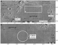
http://www.planetary.org/blogs/jason-davis...er-feature.html In particular it contains details of the landing site, and it is one I had not seen mentioned before. The previous site information which I posted above was from an LPSC presentation, but this is different - the NW edge of Mare Serenitatis. In the earlier work mare areas were ruled out as not suitable for the use of their laser altimeter (too dark, reducing the reflected signal). Back to the (map) drawing board! (or as I call it, the kitchen table). Phil EDIT: Oops, here is an earlier statement: https://www.israel21c.org/israeli-space-tea...g-for-the-moon/ I had seen it but had foolishly discounted it because of the earlier prohibition on dark mare surfaces. -------------------- ... because the Solar System ain't gonna map itself.
Also to be found posting similar content on https://mastodon.social/@PhilStooke Maps for download (free PDF: https://upload.wikimedia.org/wikipedia/comm...Cartography.pdf NOTE: everything created by me which I post on UMSF is considered to be in the public domain (NOT CC, public domain) |
|
|
|
|
Dec 13 2018, 08:05 AM
Post
#7
|
|
|
Solar System Cartographer Group: Members Posts: 10227 Joined: 5-April 05 From: Canada Member No.: 227 |
Follow-on to the naming story - SpaceIL has just tweeted their name for the lander, which had been called Sparrow since the very beginning. Now it has a new name, Beresheet, meaning 'in the beginning' (or 'Genesis').
Phil -------------------- ... because the Solar System ain't gonna map itself.
Also to be found posting similar content on https://mastodon.social/@PhilStooke Maps for download (free PDF: https://upload.wikimedia.org/wikipedia/comm...Cartography.pdf NOTE: everything created by me which I post on UMSF is considered to be in the public domain (NOT CC, public domain) |
|
|
|
|
Dec 18 2018, 09:29 PM
Post
#8
|
||
|
Solar System Cartographer Group: Members Posts: 10227 Joined: 5-April 05 From: Canada Member No.: 227 |
This is the new SpaceIL landing area. Launch now set for February 2019 on a rideshare Falcon 9.
Phil
EDIT: updated the map on 19 December -------------------- ... because the Solar System ain't gonna map itself.
Also to be found posting similar content on https://mastodon.social/@PhilStooke Maps for download (free PDF: https://upload.wikimedia.org/wikipedia/comm...Cartography.pdf NOTE: everything created by me which I post on UMSF is considered to be in the public domain (NOT CC, public domain) |
|
|
|
|
|
|
Dec 18 2018, 09:41 PM
Post
#9
|
|
|
Member Group: Members Posts: 279 Joined: 19-August 07 Member No.: 3299 |
QUOTE (Phil Stooke @ Dec 18 2018, 03:29 PM)  This is the new SpaceIL landing area. Launch now set for February 2019 on a rideshare Falcon 9. Phil [attachment=43905:landing_area.jpg] How high is the map calibrated? The landing site looks very smooth but it is not true if the picture is not close enough to see better about the roughness of the surface. |
|
|
|
|
Dec 18 2018, 09:48 PM
Post
#10
|
|
|
Solar System Cartographer Group: Members Posts: 10227 Joined: 5-April 05 From: Canada Member No.: 227 |
You are referring to the scale of the map, and as you say, at this scale we don't see small hazards. But we do see large hazards and they are nearly absent from this area. No part of the Moon is really smooth.
Phil -------------------- ... because the Solar System ain't gonna map itself.
Also to be found posting similar content on https://mastodon.social/@PhilStooke Maps for download (free PDF: https://upload.wikimedia.org/wikipedia/comm...Cartography.pdf NOTE: everything created by me which I post on UMSF is considered to be in the public domain (NOT CC, public domain) |
|
|
|
|
Dec 19 2018, 05:33 PM
Post
#11
|
|
|
Member Group: Members Posts: 279 Joined: 19-August 07 Member No.: 3299 |
To refresh news from SpaceIL
http://www.moondaily.com/reports/Israeli_s...ourney_999.html Already very soon, perhaps in two months for the launch. |
|
|
|
|
Dec 28 2018, 12:19 PM
Post
#12
|
|
 Member Group: Members Posts: 127 Joined: 3-September 12 From: Almeria, SE Spain Member No.: 6632 |
QUOTE (Phil Stooke @ Dec 18 2018, 10:29 PM) This is the new SpaceIL landing area. Launch now set for February 2019 on a rideshare Falcon 9. The date is NET 13-February. The ride is shared with Indonesia’s PSN-6 communications satellite. https://www.teslarati.com/spacex-falcon-9-c...anetary-launch/ The 13-Feb is the date that was originally foreseen as the landing date, with launch in December 2018. The lunar phase on Feb-13 is 8 days old, this means good timing for an early morning landing. Of course this will not happen this way because the trip to the Moon also needs a few days. So I expect the landing at least one month later (mid-March), or maybe even two if they follow the original flight plan. Best Thorsten PS: EDIT: "with launch in December 2018", not 2017. |
|
|
|
|
Feb 19 2019, 08:41 AM
Post
#13
|
|
|
Member Group: Members Posts: 127 Joined: 3-September 12 From: Almeria, SE Spain Member No.: 6632 |
Launch of SpaceIL's Beresheet Lunar Lander next Thursday (Friday UTC)!
https://edition.cnn.com/2019/02/18/middleea...intl/index.html Landing on April 11, this seems less then one day from local sunrise. Interesting! Thorsten |
|
|
|
|
Feb 21 2019, 08:26 AM
Post
#14
|
|
|
Member Group: Members Posts: 127 Joined: 3-September 12 From: Almeria, SE Spain Member No.: 6632 |
Somewhere (I don't find it anymore
 ) ) I read that April 11 is the date of LOI, followed by another week of orbiting the Moon. This would mean landing around local noon, what makes more sense... Thorsten |
|
|
|
|
Feb 21 2019, 10:45 AM
Post
#15
|
|
 Senior Member Group: Members Posts: 1729 Joined: 3-August 06 From: 43° 35' 53" N 1° 26' 35" E Member No.: 1004 |
there is a good recap of the mission on the Nature website:
https://www.nature.com/articles/d41586-019-00634-8 |
|
|
|
|

|
Lo-Fi Version | Time is now: 25th September 2024 - 10:14 AM |
|
RULES AND GUIDELINES Please read the Forum Rules and Guidelines before posting. IMAGE COPYRIGHT |
OPINIONS AND MODERATION Opinions expressed on UnmannedSpaceflight.com are those of the individual posters and do not necessarily reflect the opinions of UnmannedSpaceflight.com or The Planetary Society. The all-volunteer UnmannedSpaceflight.com moderation team is wholly independent of The Planetary Society. The Planetary Society has no influence over decisions made by the UnmannedSpaceflight.com moderators. |
SUPPORT THE FORUM Unmannedspaceflight.com is funded by the Planetary Society. Please consider supporting our work and many other projects by donating to the Society or becoming a member. |
|