Chang'e-4 farside landing mission |

  |
Chang'e-4 farside landing mission |
 Sep 14 2019, 06:40 PM Sep 14 2019, 06:40 PM
Post
#256
|
|
|
Solar System Cartographer  Group: Members Posts: 10227 Joined: 5-April 05 From: Canada Member No.: 227 |
post 2287 on this forum page:
http://www.9ifly.cn/thread-5819-115-1.html gives a summary of the mission including confirming what I had thought, that in May autonomous hazard detection and avoidance was tested on Yutu 2. It includes two images of a route map which I will se to update our map, when I can get to it (I'm on the road at the moment). Phil -------------------- ... because the Solar System ain't gonna map itself.
Also to be found posting similar content on https://mastodon.social/@PhilStooke Maps for download (free PDF: https://upload.wikimedia.org/wikipedia/comm...Cartography.pdf NOTE: everything created by me which I post on UMSF is considered to be in the public domain (NOT CC, public domain) |
 |
 
|
|
Sep 16 2019, 06:43 PM
Post
#257
|
|||
|
Solar System Cartographer Group: Members Posts: 10227 Joined: 5-April 05 From: Canada Member No.: 227 |
Andrew Jones directed me to this drive diary for the 9th day:
https://mp.weixin.qq.com/s/NAm3JQHLJymMOofpGX4pHQ It includes a mosaic which can be roughly reprojected to give this:
The day 9 tracks are at left. The diary describes efforts to analyze the odd material in the crater (open in Chrome for a rough translation). Here I show an interpretation of the pattern of tracks. Not sure I have it right. The mosaic is from the end of day 9.
Map update will follow when I can get to it (I'm on vacation in Brittany) Phil -------------------- ... because the Solar System ain't gonna map itself.
Also to be found posting similar content on https://mastodon.social/@PhilStooke Maps for download (free PDF: https://upload.wikimedia.org/wikipedia/comm...Cartography.pdf NOTE: everything created by me which I post on UMSF is considered to be in the public domain (NOT CC, public domain) |
||
|
|
|
||
|
Sep 16 2019, 08:20 PM
Post
#258
|
|
|
Member Group: Members Posts: 157 Joined: 22-May 09 From: Ireland Member No.: 4792 |
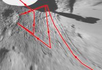
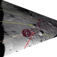
I'll assume that the first image below is a track-image of where Yutu-2 pulled back (because of the first VNIS wasn't suitable), and then progressed forwards to conduct a second view as highlighted below in the second image (colouration is simply for clarification of the area concerned).
John   Also, I'm assuming, the highlighted sector (on left of the third image below) is relative to the sharp angles pronounced in Phil's image. 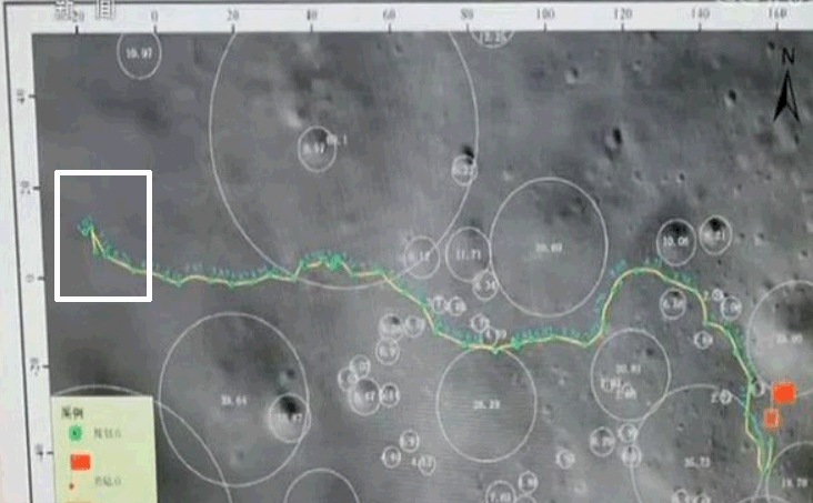 John |
|
|
|
|
Oct 8 2019, 05:55 PM
Post
#259
|
|
|
Solar System Cartographer Group: Members Posts: 10227 Joined: 5-April 05 From: Canada Member No.: 227 |
https://www.weibo.com/ttarticle/p/show?id=2...425030623690756
This link is to a rover diary for lunar day 10. Using Chrome to translate, it seems that some technical issues had to be overcome (sun sensor and knowledge of attitude) so not much movement this month - Andrew Jones tweeted that the drive was only about 5 m. Yutu 2 is still near the small crater with a bit of glass in it (and there's a photo of the sparkly glass in the article) and either made a new analysis with better lighting or is going to do that before they leave. Phil -------------------- ... because the Solar System ain't gonna map itself.
Also to be found posting similar content on https://mastodon.social/@PhilStooke Maps for download (free PDF: https://upload.wikimedia.org/wikipedia/comm...Cartography.pdf NOTE: everything created by me which I post on UMSF is considered to be in the public domain (NOT CC, public domain) |
|
|
|
|
Oct 15 2019, 12:11 AM
Post
#260
|
||
|
Solar System Cartographer Group: Members Posts: 10227 Joined: 5-April 05 From: Canada Member No.: 227 |
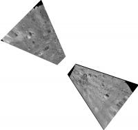
https://twitter.com/AJ_FI/status/1183671036958642176
Here Andrew Jones tweets some more images from Yutu 2 including nice views of the central peak and the tracks behind the rover. I have projected those images (very roughly) to help with mapping. Phil
-------------------- ... because the Solar System ain't gonna map itself.
Also to be found posting similar content on https://mastodon.social/@PhilStooke Maps for download (free PDF: https://upload.wikimedia.org/wikipedia/comm...Cartography.pdf NOTE: everything created by me which I post on UMSF is considered to be in the public domain (NOT CC, public domain) |
|
|
|
|
|
|
Oct 15 2019, 10:35 PM
Post
#261
|
|||
|
Solar System Cartographer Group: Members Posts: 10227 Joined: 5-April 05 From: Canada Member No.: 227 |
That was a very crude reprojection of the tracks image for initial planning work. Here is a better version.
Phil
-------------------- ... because the Solar System ain't gonna map itself.
Also to be found posting similar content on https://mastodon.social/@PhilStooke Maps for download (free PDF: https://upload.wikimedia.org/wikipedia/comm...Cartography.pdf NOTE: everything created by me which I post on UMSF is considered to be in the public domain (NOT CC, public domain) |
||
|
|
|
||
|
Oct 25 2019, 08:41 PM
Post
#262
|
|
|
Member Group: Members Posts: 866 Joined: 15-March 05 From: Santa Cruz, CA Member No.: 196 |
latest on the starch wreck gummies.. new article on space.com has some processed images
|
|
|
|
|
Nov 14 2019, 09:12 PM
Post
#263
|
|
|
Member Group: Members Posts: 157 Joined: 22-May 09 From: Ireland Member No.: 4792 |
|
|
|
|
|
Nov 14 2019, 09:46 PM
Post
#264
|
||
|
Solar System Cartographer Group: Members Posts: 10227 Joined: 5-April 05 From: Canada Member No.: 227 |
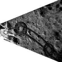
A very nice bit of work there by Cees Bassa, Daniel Estevez and others. This comparison of the before and after images shows the difference between the two frames, with increased contrast. The images were just taken from the release, obviously.
At first I thought the ejecta was deflected off the approach vector by the steep slope, but the difference image makes me feel it is more symmetrical. Phil
-------------------- ... because the Solar System ain't gonna map itself.
Also to be found posting similar content on https://mastodon.social/@PhilStooke Maps for download (free PDF: https://upload.wikimedia.org/wikipedia/comm...Cartography.pdf NOTE: everything created by me which I post on UMSF is considered to be in the public domain (NOT CC, public domain) |
|
|
|
|
|
|
Nov 14 2019, 10:32 PM
Post
#265
|
|
|
Member Group: Members Posts: 157 Joined: 22-May 09 From: Ireland Member No.: 4792 |
It truly is extraordinary from the LRO perspective -- given the very minute change in the terrain texture surface (barely noticeable by none of us, really).
John More |
|
|
|
|
Nov 20 2019, 07:09 PM
Post
#266
|
||||
|
Solar System Cartographer Group: Members Posts: 10227 Joined: 5-April 05 From: Canada Member No.: 227 |
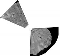
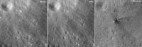
There is a new drive diary for CE4's day 11 here:
https://mp.weixin.qq.com/s/XpmEyGIC9GmLWvB40L_CkA (in Chinese). It includes links to past reports, which is really useful. Here are versions of the images posted, processed to help make sense of the surroundings and tracks. Orientations are only approximate. Thanks to Andrew Jones for drawing attention to this via a tweet. He also reports that Yutu 2 is just starting its 12th lunar day. Phil Before a tricky drive; after that drive, partial panorama late in the day (note faint tracks if you zoom in).
-------------------- ... because the Solar System ain't gonna map itself.
Also to be found posting similar content on https://mastodon.social/@PhilStooke Maps for download (free PDF: https://upload.wikimedia.org/wikipedia/comm...Cartography.pdf NOTE: everything created by me which I post on UMSF is considered to be in the public domain (NOT CC, public domain) |
|||
|
|
|
|||
|
Nov 21 2019, 02:45 PM
Post
#267
|
||||
|
Newbie Group: Members Posts: 1 Joined: 11-November 19 Member No.: 8704 |
Great work Phil!
I am a Cartographer and a GISer working for NAOC, China. Our team are doing the data preprocess and release for CE4 science data, according to the the data release policy of China Lunar Exploration Program(CLEP), the CE4 science data will be released in a year after the data are acquried, since CE4 started to get lunar image in Jan 3rd,2019; so the first batch of CE4 science data will be released around Jan 3rd,2020.(http://moon.bao.ac.cn) Hope it would be useful for you. PS. We have planned to build a China Lunar and Planetary Data Node in 2020, Using PDS Standard, then international cooperation are neccessary, and any suggestion or questiones are warmly welcomed. zengxingguo zengxg@nao.cas.cn QUOTE (Phil Stooke @ Nov 21 2019, 03:09 AM)  There is a new drive diary for CE4's day 11 here: https://mp.weixin.qq.com/s/XpmEyGIC9GmLWvB40L_CkA (in Chinese). It includes links to past reports, which is really useful. Here are versions of the images posted, processed to help make sense of the surroundings and tracks. Orientations are only approximate. Thanks to Andrew Jones for drawing attention to this via a tweet. He also reports that Yutu 2 is just starting its 12th lunar day. Phil Before a tricky drive; after that drive, partial panorama late in the day (note faint tracks if you zoom in).
|
|||
|
|
|
|||
|
Nov 21 2019, 09:24 PM
Post
#268
|
|
|
Solar System Cartographer Group: Members Posts: 10227 Joined: 5-April 05 From: Canada Member No.: 227 |
Thanks for your very useful information. I had seen your tweet about the new data node, and it will be very exciting for all of us to see the released data. I will be especially interested in seeing assembled panoramas, on the multimedia site at http://moon.bao.ac.cn or in the archive. It has been very interesting to follow the mission even though our information is limited.
Phil -------------------- ... because the Solar System ain't gonna map itself.
Also to be found posting similar content on https://mastodon.social/@PhilStooke Maps for download (free PDF: https://upload.wikimedia.org/wikipedia/comm...Cartography.pdf NOTE: everything created by me which I post on UMSF is considered to be in the public domain (NOT CC, public domain) |
|
|
|
|
Nov 25 2019, 10:11 PM
Post
#269
|
|
 Senior Member Group: Members Posts: 1452 Joined: 26-July 08 Member No.: 4270 |
A lot of new, high-resolution Chang'e 4 images have now appeared on that website.
http://moon.bao.ac.cn/mul/index/list -------------------- -- Hungry4info (Sirius_Alpha)
|
|
|
|
|
Nov 25 2019, 11:56 PM
Post
#270
|
||
|
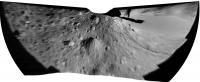
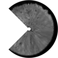
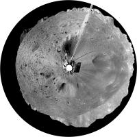
Solar System Cartographer Group: Members Posts: 10227 Joined: 5-April 05 From: Canada Member No.: 227 |
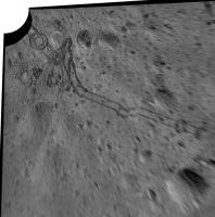
Yes! Something I had been waiting for. Click a thumbnail, and then click the larger version to get the full size. Here is a panorama made by the lander late in Day 1, in a circular projection to show a more map-like view of the landing site.
Phil
-------------------- ... because the Solar System ain't gonna map itself.
Also to be found posting similar content on https://mastodon.social/@PhilStooke Maps for download (free PDF: https://upload.wikimedia.org/wikipedia/comm...Cartography.pdf NOTE: everything created by me which I post on UMSF is considered to be in the public domain (NOT CC, public domain) |
|
|
|
|
|
|

|
Lo-Fi Version | Time is now: 24th September 2024 - 03:37 PM |
|
RULES AND GUIDELINES Please read the Forum Rules and Guidelines before posting. IMAGE COPYRIGHT |
OPINIONS AND MODERATION Opinions expressed on UnmannedSpaceflight.com are those of the individual posters and do not necessarily reflect the opinions of UnmannedSpaceflight.com or The Planetary Society. The all-volunteer UnmannedSpaceflight.com moderation team is wholly independent of The Planetary Society. The Planetary Society has no influence over decisions made by the UnmannedSpaceflight.com moderators. |
SUPPORT THE FORUM Unmannedspaceflight.com is funded by the Planetary Society. Please consider supporting our work and many other projects by donating to the Society or becoming a member. |
|