Haskin Ridge, The Eastern Route Down to the Basin |

  |
Haskin Ridge, The Eastern Route Down to the Basin |
 Oct 31 2005, 12:34 AM Oct 31 2005, 12:34 AM
Post
#166
|
|
 Senior Member  Group: Moderator Posts: 2262 Joined: 9-February 04 From: Melbourne - Oz Member No.: 16 |
Well data tracking is back and it looks like were back on the road tosol (649)
649 p0655.03 0 0 0 0 0 0 navcam_5x1_az_90_3_bpp 649 p1201.17 0 0 0 0 0 0 front_haz_penultimate_1_bpp_crit_16 649 p1214.05 0 0 0 0 0 0 front_hazcam_ultimate_4_bpp 649 p1301.06 0 0 0 0 0 0 penultimate_rear_hazcam_pri_16 649 p1312.09 0 0 0 0 0 0 ultimate_rear_hazcam_2_bpp_pri15 649 p1755.01 0 0 0 0 0 0 navcam_5x1_az_270_1_bpp and including 649 p2396.06 0 0 0 0 0 0 pancam_drive_direction_6cx1r_L7R1 James - hoping for a view down the step... -------------------- |
 |
 
|
|
Oct 31 2005, 02:00 AM
Post
#167
|
|
|
Senior Member Group: Members Posts: 1636 Joined: 9-May 05 From: Lima, Peru Member No.: 385 |
What disbelief is that PANCAM Data Tracking is back after we have speculated that it was protected by the userid and password identification was due of others reasons...
 I am happy it is back again. Hope we don't abuse it since it is a Web dynamic driven that consumes lots of CPU cycles. My guess to PANCAM Data Tracking as the following navcam_5x1_az_90_3_bpp ---------------> Take 5 pictures to south side front_haz_penultimate_1_bpp_crit_16 --> Take front picture early front_hazcam_ultimate_4_bpp ------------> Take front picture after some ride penultimate_rear_hazcam_pri_16 ---------> Take rear picture early (same as front) ultimate_rear_hazcam_2_bpp_pri15 ------> Take rear picture after some ride. navcam_5x1_az_270_1_bpp --------------> Take 5 picture to east side and including pancam_drive_direction_6cx1r_L7R1 ----> Take 6 pictures of PANCAM in drive direction Rodolfo |
|
|
|
|
Oct 31 2005, 03:09 AM
Post
#168
|
|
|
Senior Member Group: Moderator Posts: 2262 Joined: 9-February 04 From: Melbourne - Oz Member No.: 16 |
QUOTE (RNeuhaus @ Oct 31 2005, 12:00 PM) My guess to PANCAM Data Tracking as the following navcam_5x1_az_90_3_bpp ---------------> Take 5 pictures to south side front_haz_penultimate_1_bpp_crit_16 --> Take front picture early front_hazcam_ultimate_4_bpp ------------> Take front picture after some ride penultimate_rear_hazcam_pri_16 ---------> Take rear picture early (same as front) ultimate_rear_hazcam_2_bpp_pri15 ------> Take rear picture after some ride. navcam_5x1_az_270_1_bpp --------------> Take 5 picture to east side and including pancam_drive_direction_6cx1r_L7R1 ----> Take 6 pictures of PANCAM in drive direction Rodolfo  Yes, clearly we have a drive with 360 deg navcam pan and 6 frame pancam pan of the drop-off after, like we've seen many times already. (There also looks like there will be some pancam work of the area they have just been working and of the RAT.) Question is: How far will the drive be? We were only 20m from the drop-off so we could end up quite close to it after this drive. Here's hoping!  James -------------------- |
|
|
|
|
Oct 31 2005, 10:39 AM
Post
#169
|
||
|
Senior Member Group: Members Posts: 1870 Joined: 20-February 05 Member No.: 174 |
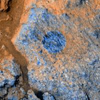
Here's a Band L2 and L7 two-color image of the RAT-Brushed target they're investigating 20 meters from the presumed step down toward Haskin ridge.
VERY interesting texture.
Attached thumbnail(s)
|
|
|
|
|
|
|
Oct 31 2005, 10:58 AM
Post
#170
|
|||
|
Senior Member Group: Members Posts: 1870 Joined: 20-February 05 Member No.: 174 |
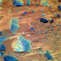
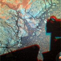
From a few days ago, and a couple days or so before that.. some of the rocks on the descending slope. Sharpened color from band L2/L5/L7 raw images. Contrast tweeked, but color not boosted other than from the pre-stretch the raws were given.
2P183362581EFFAI38P2556L2M1_257.jpg looks like rotten concrete. Very clearly a grungy clastic rock, looking not very well assembled from ground up crud. Very techical geologic terms, these!. Well... Clastic is. 2P182828219EFFAF00P2456L2M1_257.jpg has infinite color variations on the rock surfaces, but most of it is dominated by adhering dust and weathering rinds or other coatings on the surfaces. Jim Bell and the Pancan team can see spectral classes of rocks in the 11 channel data, but I sure can't tell them from the color pics made from 3 bands of raw data. Eventually, we'll need software that can look at a MSL scene and sort multiband data into color combinations that suppress the high contrast ferric dust features and bring out the variations in underlying rock, so we can look at a pan and say... We've done "those".. I want to take a good look at "THAT" one.. it's DIFFERENT. And we'll need to be able to do it in time for tomorrows science planning meeting to uplink the rock's coordinates and a "go GET IT" command to the rover.
Attached thumbnail(s)
|
||
|
|
|
||
|
Oct 31 2005, 12:04 PM
Post
#171
|
|
 Dublin Correspondent Group: Admin Posts: 1799 Joined: 28-March 05 From: Celbridge, Ireland Member No.: 220 |
QUOTE (edstrick @ Oct 31 2005, 11:58 AM) Eventually, we'll need software that can look at a MSL scene and sort multiband data into color combinations that suppress the high contrast ferric dust features and bring out the variations in underlying rock, so we can look at a pan and say... We've done "those".. I want to take a good look at "THAT" one.. it's DIFFERENT. And we'll need to be able to do it in time for tomorrows science planning meeting to uplink the rock's coordinates and a "go GET IT" command to the rover. That's an interesting topic, and somewhat in line with Steve Squyres' comments on capabilities for next gen missions. Right now the MER drivers and planners have to do a lot of work just to move from point to point, get their bearings and check the atmospheric conditions before doing anything. On top of that the science guys have to slog through loads of data to pick out targets. All good work and plenty of fun but I'm curious about how much autonomy is planned for MSL. In terms of covering ground it would be much smarter to be able to upload a local terrain model (from MRO I assume) throw in some way points and have automated systems exhaustively characterise multispectral reconnaissance pans on the fly searching for anything out of the ordinary. I don't think that can be done yet, or at least can't be done yet with a high enough level of confidence to rely on it. If that is the case is MSL going to be limited to a similar rate of progress to the MER's ? |
|
|
|
|
Oct 31 2005, 05:35 PM
Post
#172
|
|
 Senior Member Group: Members Posts: 4247 Joined: 17-January 05 Member No.: 152 |
New navcam imagery of the dropoff here on sol 649 after the latest drive. Looking at the LR pair in 3D, it looks like our line of sight is now just parallel to the steepest part of the dropoff slope, ie we are just able to see almost all of the slope. Therefore my slope technique gives 20 to 21 degrees for the steepest part, which sounds totally doable!
|
|
|
|
|
Oct 31 2005, 06:35 PM
Post
#173
|
|
|
Senior Member Group: Moderator Posts: 4279 Joined: 19-April 05 From: .br at .es Member No.: 253 |
Parallax measurements on navcam pics say that sol 649 drive was about 14m.
|
|
|
|
|
Oct 31 2005, 06:54 PM
Post
#174
|
|
|
Member Group: Members Posts: 877 Joined: 7-March 05 From: Switzerland Member No.: 186 |
Spirit you are on the right track... (2,13 MB) http://www.greuti.ch/spirit/spirit_pancam_sol649.jpg There is a way, isn'it! Btw. on Exploratorium the 2005-10-31 Pancam file that's huge and slow - but it's alive! Thank you Exploratorium!
-------------------- |
|
|
|
|
Oct 31 2005, 07:45 PM
Post
#175
|
|
|
Member Group: Members Posts: 877 Joined: 7-March 05 From: Switzerland Member No.: 186 |
QUOTE (jvandriel @ Oct 26 2005, 01:35 PM) But in general I must say that the anti-vignetting program of MichaelT is a great help for making better panoramas. Special in the Navcam panoramas you can see much better results. In the pancam images it is less, because they have less vignetting as explained earlier in another thread. jvandriel I used MichaelT's anti-vignetting program for my last three L7/R1 Pancam pans too. Would like to say, along with PTGui the process getting a good result is faster and easier with it. The single frame becomes more balance in brightness/darkness and match already better before finally processing in PS. And I have to add, pans without any automatic brightness/color correction during stitching (so far). -------------------- |
|
|
|
|
Oct 31 2005, 09:01 PM
Post
#176
|
||
|
Senior Member Group: Moderator Posts: 4279 Joined: 19-April 05 From: .br at .es Member No.: 253 |
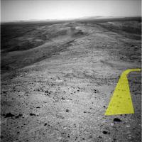
QUOTE (Tman @ Oct 31 2005, 08:54 PM) There is a way, isn'it! Think so. I see plenty of possible ways to go down; here is my preferred one.
Attached thumbnail(s)
|
|
|
|
|
|
|
Oct 31 2005, 09:25 PM
Post
#177
|
|
|
Senior Member Group: Members Posts: 1636 Joined: 9-May 05 From: Lima, Peru Member No.: 385 |
QUOTE (Tesheiner @ Oct 31 2005, 04:01 PM) Think so. I see plenty of possible ways to go down; here is my preferred one. By that yellow way there are no interesting stones or rocks.... Rodolfo |
|
|
|
|
Oct 31 2005, 09:51 PM
Post
#178
|
|
 Senior Member Group: Admin Posts: 4763 Joined: 15-March 05 From: Glendale, AZ Member No.: 197 |
Your rover is leaking something.
-------------------- If Occam had heard my theory, things would be very different now.
|
|
|
|
|
Oct 31 2005, 10:59 PM
Post
#179
|
|
 Member Group: Members Posts: 753 Joined: 23-October 04 From: Greensboro, NC USA Member No.: 103 |
Follow the Yellow Brick Road!
-------------------- Jonathan Ward
Manning the LCC at http://www.apollolaunchcontrol.com |
|
|
|
|
Nov 1 2005, 08:59 AM
Post
#180
|
|
|
Member Group: Members Posts: 877 Joined: 7-March 05 From: Switzerland Member No.: 186 |
Can anybody find a match between the sol 649 Navcams and Pancams? I guess the part of Tesheiner's yellow path isn't visible in the Pancams from sol 649.
-------------------- |
|
|
|
|

|
Lo-Fi Version | Time is now: 28th May 2024 - 03:22 AM |
|
RULES AND GUIDELINES Please read the Forum Rules and Guidelines before posting. IMAGE COPYRIGHT |
OPINIONS AND MODERATION Opinions expressed on UnmannedSpaceflight.com are those of the individual posters and do not necessarily reflect the opinions of UnmannedSpaceflight.com or The Planetary Society. The all-volunteer UnmannedSpaceflight.com moderation team is wholly independent of The Planetary Society. The Planetary Society has no influence over decisions made by the UnmannedSpaceflight.com moderators. |
SUPPORT THE FORUM Unmannedspaceflight.com is funded by the Planetary Society. Please consider supporting our work and many other projects by donating to the Society or becoming a member. |
|