The Geology of Jezero Crater, Observations & Findings |

  |
The Geology of Jezero Crater, Observations & Findings |
 Mar 9 2021, 01:17 AM Mar 9 2021, 01:17 AM
Post
#91
|
||
|
Senior Member  Group: Members Posts: 1045 Joined: 17-February 09 Member No.: 4605 |
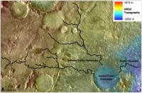
Andreas, despite erosion there are obvious remnants of tributaries to the main river. The image below is taken from https://www.sciencedirect.com/science/artic...03206331200044X
Attached thumbnail(s)
|
|
 |
 
|
|
|
Mar 9 2021, 02:29 AM
Post
#92
|
|
|
Member Group: Members Posts: 248 Joined: 25-February 21 From: Waltham, Massachussetts, U.S.A. Member No.: 8974 |
There are sedimentologists specializing in landscape evolution and numerical modeling, see for example https://agupubs.onlinelibrary.wiley.com/doi...1002/jgrf.20031 . Consequently, there are a large number of models, based on diffusion or advection concepts. Unfortunately, I am not such a modeler and do not have that insight. My inclination would be to treat lower gravity similar to a change in slope both acting on the erosional effect at the river base in similar ways. Slope is just one parameter besides flow rate, sediment load or potentially tectonic uplift or subsidence.
With that in mind I would expect that 0.38g would require a much steeper slope for a stream to develop similar erosional characteristics, other parameters being equal (which would be difficult to establish). The 2km relief over 100km intuitively feels rather steep and it should be possible to find longitudinal river profiles of similar length, for a direct comparison. A main difference is that the profile does not look like a textbook river profile on earth which has a steep initial gradient, an intermediate section, and a very gentle final gradient before entering a base line (a lake or ocean) which is considered an equilibrium profile where erosion at the source and aggradation at the sink are in balance. I suspect that there have been attempts to understand such profiles on Mars, after the idea of an early wet history was getting (more?) widely accepted. Looking more closely along the stream, there are what could be rather short tributaries, and perhaps drainage from the Hargraves crater region to the north. Proposing a secondary inlet at the northern crater rim clearly requires some interpretation since it would be not very well preserved. I do think there are markers of channeling and meandering further upstream which seem to connect to it. [edit] ah Thanks serpens, yes that is what I see as well. It is just not much of a system of tributaries. -------------------- --
Andreas Plesch, andreasplesch at gmail dot com |
|
|
|
|
Mar 9 2021, 02:43 AM
Post
#93
|
|
 Member Group: Members Posts: 153 Joined: 8-February 04 From: Phoenix, AZ USA Member No.: 9 |
QUOTE (JRehling @ Mar 8 2021, 07:27 PM)  With both respect and gratitude for the expertise of the terrestrial geologists, would the different geophysical properties on Mars adjust some of the parameters in a predictable way. E.g., at 0.38g, would the slower flow downslope flow of rivers at a given slope change the morphology in predictable ways? Nice recent papers on the subject: https://pubs.geoscienceworld.org/gsa/geolog...J8C5xSG4mS7RX60 https://www.sciencedirect.com/science/artic...019103520305716 Summary: Yes, we should expect differences, but they may be subtle. Morphodynamic comparisons of Martian and terrestrial channels, both fluvial and submarine, show the same geometric relationships. Bedforms may form at different shear stress - grain size conditions and there will be differences in bedload versus suspended load transport. The Amy and Dorrell paper does predict that the upper reaches of graded suspended load rivers in less than earth gravity will have gentler slopes, as Andreas observed in his long profile. -------------------- Tim Demko
BioLink site |
|
|
|
|
Mar 9 2021, 02:54 AM
Post
#94
|
|
|
Member Group: Members Posts: 248 Joined: 25-February 21 From: Waltham, Massachussetts, U.S.A. Member No.: 8974 |
I find myself agreeing with much of what the abstract says:
https://doi.org/10.1016/j.pss.2012.02.003 But I would be less certain about not having cycles of deposition, and erosion, or perhaps completely drying out the Lake. We already saw at least two cycles of progradation and regression on top of each other, with the benefit of ground views. The sudden end of the Lake, leaving the proximal part of the delta largely intact and unincised is just the final act of potentially millions of years of depositional history, as the authors suggest. -------------------- --
Andreas Plesch, andreasplesch at gmail dot com |
|
|
|
|
Mar 9 2021, 10:20 AM
Post
#95
|
|
|
Member Group: Members Posts: 240 Joined: 18-July 06 Member No.: 981 |
Do we have any insight as to why the small deltaic remnants exist at such a distance from the main delta front? Did they move somehow from where they were emplaced? What could cause the significant and remarkably complete (scoured clean down to the top of the underlying unit) erosion of the delta material and what saved these remnants which are presumably analogues of the main delta. Could they have been islands in the lake?
The interesting one (to me) to the north looks much like a volcano from above with no clear evidence of stratification. There are some concentric dust rings that might relate to strata but its hard to be sure. Getting a close look at that might yield some useful information about the delta and the erosional processes that have sculpted the front. |
|
|
|
|
Mar 9 2021, 11:22 AM
Post
#96
|
|
|
Forum Contributor Group: Members Posts: 1372 Joined: 8-February 04 From: North East Florida, USA. Member No.: 11 |
QUOTE (MarkL @ Mar 9 2021, 10:20 AM) Do we have any insight as to why the small deltaic remnants exist at such a distance from the main delta front? Did they move somehow from where they were emplaced? What could cause the significant and remarkably complete (scoured clean down to the top of the underlying unit) erosion of the delta material and what saved these remnants which are presumably analogues of the main delta. Could they have been islands in the lake? Likely chance and the vagaries of the wind over billions of years. |
|
|
|
|
Mar 9 2021, 12:14 PM
Post
#97
|
||
 Member Group: Members Posts: 684 Joined: 24-July 15 Member No.: 7619 |
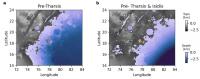
QUOTE Do we have any insight as to why the small deltaic remnants exist at such a distance from the main delta front? Did they move somehow from where they were emplaced? What could cause the significant and remarkably complete (scoured clean down to the top of the underlying unit) erosion of the delta material and what saved these remnants which are presumably analogues of the main delta. Could they have been islands in the lake? The interesting one (to me) to the north looks much like a volcano from above with no clear evidence of stratification. There are some concentric dust rings that might relate to strata but it’s hard to be sure. Getting a close look at that might yield some useful information about the delta and the erosional processes that have sculpted the front. Remember the entire area may have dropped 2 km and tilted during the millions of years of Tharsis volcanism. Then is probably tilted again during the Isidris basin volcanism. During the era of the Arabia Ocean Jezro could have been a coastal crater partially below sea level. Tharsis volcanism would have dropped Jezro up to 2 km below the Arabia Ocean sea level (if that ocean was still there). During the later era of the Deuteronilus Ocean, Jezro could have been an inland lake feeding into a great lake in Isidris. QUOTE ARE WE VISITING THE COASTLINES OF MARS? LOAD-CORRECTED PALEO-OCEAN LEVELS AT
JEZERO, OXIA PLANUM, AND GALE. R. I. Citron , M. Manga , D. Hemingway and A. Plattner https://www.hou.usra.edu/meetings/lpsc2021/pdf/1605.pdf
Attached thumbnail(s)
|
|
|
|
|
|
|
Mar 9 2021, 02:36 PM
Post
#98
|
|
|
Senior Member Group: Members Posts: 1045 Joined: 17-February 09 Member No.: 4605 |
QUOTE (Andreas Plesch @ Mar 9 2021, 03:29 AM) ....It is just not much of a system of tributaries. While the catchment as it stands can be reasonably constrained, as HSchirmer alludes to the area has been subject to tectonic activity, cratering and erosion that makes the accurate assessment of the ancient drainage area and tributary flows challenging to say the least. While there are traces of the tributaries much has been erased. As I understand it the mineralogy of the Northern and Southern deltas vary, reflecting the mineralogy of the two separate catchment areas. All in all it is a pretty impressive drainage area which I suspect would have hosted an extensive tributary network. |
|
|
|
|
Mar 9 2021, 03:08 PM
Post
#99
|
|
|
Member Group: Members Posts: 248 Joined: 25-February 21 From: Waltham, Massachussetts, U.S.A. Member No.: 8974 |
QUOTE (serpens @ Mar 9 2021, 09:36 AM) While the catchment as it stands can be reasonably constrained, as HSchirmer alludes to the area has been subject to tectonic activity, cratering and erosion that makes the accurate assessment of the ancient drainage area and tributary flows challenging to say the least. While there are traces of the tributaries much has been erased. As I understand it the mineralogy of the Northern and Southern deltas vary, reflecting the mineralogy of the two separate catchment areas. All in all it is a pretty impressive drainage area which I suspect would have hosted an extensive tributary network. Undoubtedly, there has been substantial vertical tectonics (with some extensional rifting) as there is so much geologic time available. Nevertheless, today the crater floor is essentially horizontal and the main stream bed is well preserved, up to a 100 miles back. So the base assumption would be that first order tributaries would be preserved to a similar degree. I agree that together the Northern and Southern deltas were supplied from a large catchment. Since the main stream to me looks relatively starved to the west and south, perhaps at times there was major supply from the north. -------------------- --
Andreas Plesch, andreasplesch at gmail dot com |
|
|
|
|
Mar 9 2021, 03:30 PM
Post
#100
|
||
|
Member Group: Members Posts: 684 Joined: 24-July 15 Member No.: 7619 |
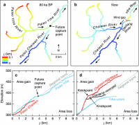
QUOTE (serpens @ Mar 9 2021, 02:36 PM) While the catchment as it stands can be reasonably constrained, as HSchirmer alludes to the area has been subject to tectonic activity, cratering and erosion that makes the accurate assessment of the ancient drainage area and tributary flows challenging to say the least. A follow up point - when tectonics tilts an entire river drainage network on 50, 200, 500, 1,000 km scale, you get paradoxes: Example is the geology / biodiversity paradox for the US east coast: 500 MY old fish populations in 200 MY old rivers. The main US coastal rivers: Hudson, Delaware, Susquehanna, Potomac, Cape Fear, Congaree & Savannah all run east from the Allegheny mountains to the Atlantic ocean. The Atlantic ocean opened up ~200 million years ago when Pangea broke up. However, 500 MY old fossils of the same fish species that are in the river now indicates the rivers are over 500 million years old. At first glance would requires the east coast rivers to run UP HILL towards the central "Himalayan plateau" of Pangea. The solution is that the river tributaries are older than the river & ocean they currently drain to, the large main stems have reversed course. All the large east coast rivers USED to be small header tributaries that drained west to the proto-Mississippi. Once the Atlantic opened, they had a steeper gradient heading east, which allowed quick erosion to gorges, which cut back to the west and captured more and more feeder rivers and streams, which accelerated erosion... https://www.researchgate.net/figure/River-n..._fig1_327653964 Conversely, as the old western-draining network lost tributaries, reduced flow leads to silting up, which slows flow, dropping even more sediment: you get a series of lakes & wetlands, rising water levels, and eventually the water level over-tops the watershed divide and begins flowing east to the Atlantic instead of west to the Mississippi. Repeat that process a few times for Jezro, add in 2 possible ocean shorelines, and you've got an idea of the scope of the question!
Attached thumbnail(s)
|
|
|
|
|
|
|
Mar 10 2021, 10:27 AM
Post
#101
|
|
|
Member Group: Members Posts: 684 Joined: 24-July 15 Member No.: 7619 |
Not sure where to post this- so, try the 'hot' posts and mods can move as needed-
It appears that the Juno probe's solar arrays inadvertently "sampled" Mars geology The space probe was pummeled and pitted by "Zodiacal Dust" which seems to be streaming off Mars. More amazing, Martian rocks are ground into fine dust, lifted by global Martian dust storms, tossed into space, constrained in a torus, only to spiral inward and float down to Earth. Even more amazing, with a ballpark estimate of of 60 tons of "space dust" per day drifting down to earth, https://www.popsci.com/60-tons-cosmic-dust-...arth-every-day/ that suggests Earth receives about 30 tons of Mars rock samples every day. They're just REALLY tiny and spread across the entire globe. SHORT QUOTE Juno data shatter ideas about origin of Zodiacal Light https://www.spacedaily.com/reports/Juno_dat..._Light_999.html LONG QUOTE Distribution of Interplanetary Dust Detected by the Juno Spacecraft and Its Contribution to the Zodiacal Light
https://agupubs.onlinelibrary.wiley.com/doi...29/2020JE006509 |
|
|
|
|
Mar 11 2021, 12:40 AM
Post
#102
|
|
 Senior Member Group: Members Posts: 4251 Joined: 17-January 05 Member No.: 152 |
QUOTE (HSchirmer @ Mar 10 2021, 11:27 AM) tossed into space To be fair, the authors say they know of no mechanism to do that, considering the escape velocity needed. |
|
|
|
|
Mar 14 2021, 09:43 PM
Post
#103
|
|
|
Member Group: Members Posts: 311 Joined: 31-August 05 From: Florida & Texas, USA Member No.: 482 |
nice to see preliminary results already!
"Scientists were able to reveal that Máaz was basaltic, meaning it contained a substantial amount of magnesium and iron, BBC News reported. They are yet to discover whether the 'rock itself is igneous, ie volcanic, or perhaps if it is a sedimentary rock made up of igneous grains that were washed downriver into Jezero lake and cemented together,' said SuperCam chief investigator, Roger Wiens" https://www.businessinsider.com/nasa-persev...lopments-2021-3 https://mars.nasa.gov/news/8885/perseveranc...-first-results/ |
|
|
|
|
Mar 15 2021, 12:40 AM
Post
#104
|
|
 Senior Member Group: Members Posts: 2530 Joined: 20-April 05 Member No.: 321 |
Martian dust is not representative of martian rock.
https://mars.nasa.gov/MPF/science/lpsc98/1723.pdf Moreover, martian meteorites are not representative of martian rock overall. There are selection biases based on altitude and durability. Sedimentary rock may be very scarce or virtually absent from the dust/meteorites that leave Mars. |
|
|
|
|
Mar 15 2021, 03:46 AM
Post
#105
|
|
|
Senior Member Group: Members Posts: 1045 Joined: 17-February 09 Member No.: 4605 |
Currently the primary source of dust is the Medusae Fossae formation which is weakly cemented and likely volcanic ash with limited mixing from erosion of other areas. It takes a pretty large impact in the right place to eject material with an escape velocity and only some 260 meteorites of Martian origin have been identified. Sedimentary rock is comparatively fragile and if it did survive ejection would probably fragment on entering Earth's atmosphere.
|
|
|
|
|

|
Lo-Fi Version | Time is now: 5th June 2024 - 09:04 AM |
|
RULES AND GUIDELINES Please read the Forum Rules and Guidelines before posting. IMAGE COPYRIGHT |
OPINIONS AND MODERATION Opinions expressed on UnmannedSpaceflight.com are those of the individual posters and do not necessarily reflect the opinions of UnmannedSpaceflight.com or The Planetary Society. The all-volunteer UnmannedSpaceflight.com moderation team is wholly independent of The Planetary Society. The Planetary Society has no influence over decisions made by the UnmannedSpaceflight.com moderators. |
SUPPORT THE FORUM Unmannedspaceflight.com is funded by the Planetary Society. Please consider supporting our work and many other projects by donating to the Society or becoming a member. |
|