Opportunity Route Map |

  |
Opportunity Route Map |
 Oct 28 2005, 04:37 PM Oct 28 2005, 04:37 PM
Post
#856
|
|
 Senior Member  Group: Moderator Posts: 3431 Joined: 11-August 04 From: USA Member No.: 98 |
QUOTE (Tesheiner @ Oct 28 2005, 01:27 PM) Based on the radials to the west crater and some features at Erebus I plotted the following positions for sols 624 and 625.  I think you're about right on 624. I couldn't begin to guess yet on 625, but if we actually moved that far that's fantastic. |
 |
 
|
|
Oct 28 2005, 05:45 PM
Post
#857
|
|
|
Member Group: Members Posts: 320 Joined: 19-June 04 Member No.: 85 |
I don't know if anyone has mentioned this, but there's a cPROTO image of Erebus available at a resolution of 0.5 meters per pixel. They actually spotted Opportunity on sol 601-605 with the image.
http://www.msss.com/mars_images/moc/2005/10/24/index.html -------------------- |
|
|
|
|
Oct 28 2005, 08:47 PM
Post
#858
|
|
|
Senior Member Group: Moderator Posts: 4279 Joined: 19-April 05 From: .br at .es Member No.: 253 |
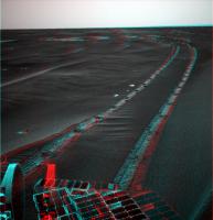
QUOTE (Bill Harris @ Oct 28 2005, 06:24 PM) I think your positions are reasonably close. It's hard to say since there are not landmarks nearby. Attached is a Sol 625 Navcam image, looking southwestward, cropped and stretched 5x. It shows the target NW outcrop and Mogollon beyond it, with the dunes to the left (East). Oppy will be heading between the ripples along the right side of this image. Once she gets to the NW outcrop the driving will be easier for a while and hopefully she'll get there before the dust storm. --Bill And take a look to a similar shot taken on sol 624; if I'm not wrong it's the first of five navcams. We can really see Oppy's advance towards that outcrop. |
|
|
|
|
Oct 28 2005, 10:40 PM
Post
#859
|
|
|
Senior Member Group: Members Posts: 2998 Joined: 30-October 04 Member No.: 105 |
I've been noticing them; the Oppy-drivers are doing a commendable job. This has some of the trickiest soil conditions that we can have and they've been making good time.
--Bill -------------------- |
|
|
|
|
Oct 29 2005, 12:41 PM
Post
#860
|
||
 Member Group: Members Posts: 362 Joined: 12-June 05 From: Kiama, Australia Member No.: 409 |
The long and winding road, quite a little hump they've driven up
Attached thumbnail(s)
|
|
|
|
|
|
|
Oct 29 2005, 01:09 PM
Post
#861
|
|
 Member Group: Members Posts: 531 Joined: 24-August 05 Member No.: 471 |
QUOTE I don't know if anyone has mentioned this Oh yes, Aldo: http://www.unmannedspaceflight.com/index.php?showtopic=1580 -------------------- - blue_scape / Nico -
|
|
|
|
|
Oct 29 2005, 02:44 PM
Post
#862
|
||
|
Senior Member Group: Moderator Posts: 4279 Joined: 19-April 05 From: .br at .es Member No.: 253 |
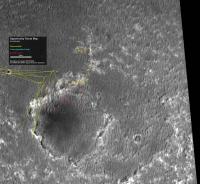
Here is what I get for Oppy position after Sol 626 drive.
I'm not 100% convinced of that one, so if anybody wants to do some distance estimations to confirm that position (or not), it will be appreciated.
Attached thumbnail(s)
|
|
|
|
|
|
|
Nov 1 2005, 09:21 PM
Post
#863
|
||
|
Senior Member Group: Moderator Posts: 4279 Joined: 19-April 05 From: .br at .es Member No.: 253 |
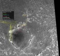
Another map, updated with sol 627 position.
I would like to have more reference points to refine the estimated position, but navcam images are only covering a small part of the rim outcrops. This will be my last map until all navcams for sols 621, 624-627 are downlinked. After that, and unless the MER team provides their updated map, I will try to improve this last version. PD: Dilo, I'm looking forward your vertical projections...
Attached thumbnail(s)
|
|
|
|
|
|
|
Nov 3 2005, 10:27 AM
Post
#864
|
||
|
Senior Member Group: Moderator Posts: 4279 Joined: 19-April 05 From: .br at .es Member No.: 253 |
New traverse maps available at the MER webside, as already noted by general on the Erebus thread.
http://marsrovers.jpl.nasa.gov/mission/tm-...nity/index.html Here is that same map overlayed on top of the one I have been using here during last drives by the sand.
You can see some discrepancy on the routes during the whole travel through the outcrops and then they almost finally fit together on sols 626 and 627. The route by the outcrops on the background map was plotted based almost completely on Dilo's work with vertical projections. I don't know your opinion, but I'm 99.9999% confident on that. Does anybody want to double-check it? As already said before, it seems that the official traverse map is displaced to the north. |
|
|
|
|
|
|
Nov 3 2005, 10:50 AM
Post
#865
|
|
|
Member Group: Members Posts: 531 Joined: 24-August 05 Member No.: 471 |
Good match up, Tesheiner.
-------------------- - blue_scape / Nico -
|
|
|
|
|
Nov 3 2005, 12:11 PM
Post
#866
|
|
|
Senior Member Group: Members Posts: 2998 Joined: 30-October 04 Member No.: 105 |
I've worked on my own version of a route map based on Oppy images with input from your and Dilo's route maps. My opinion? The route maps presented here are more accurate than the official JPL/OSU maps.
More later... --Bill -------------------- |
|
|
|
|
Nov 8 2005, 01:40 AM
Post
#867
|
||
 Senior Member Group: Members Posts: 2492 Joined: 15-January 05 From: center Italy Member No.: 150 |
Hi all.
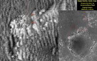
Time to return here, this map refers only to last "Mogollon" days and should be integrated from the previous ones from Bill and Tesheiner. I followed the suggestion to put projections inside MGS global image.
Attached thumbnail(s)
-------------------- I always think before posting! - Marco -
|
|
|
|
|
|
|
Nov 8 2005, 08:43 AM
Post
#868
|
|
|
Senior Member Group: Moderator Posts: 4279 Joined: 19-April 05 From: .br at .es Member No.: 253 |
Welcome back, Dilo!
 We were all missing your maps. |
|
|
|
|
Nov 8 2005, 10:10 PM
Post
#869
|
|
|
Senior Member Group: Members Posts: 2492 Joined: 15-January 05 From: center Italy Member No.: 150 |
QUOTE (Tesheiner @ Nov 8 2005, 08:43 AM) Welcome back, Dilo! We were all missing your maps. 
-------------------- I always think before posting! - Marco -
|
|
|
|
|
Nov 9 2005, 09:29 AM
Post
#870
|
|
|
Member Group: Members Posts: 877 Joined: 7-March 05 From: Switzerland Member No.: 186 |
-------------------- |
|
|
|
|

|
Lo-Fi Version | Time is now: 27th May 2024 - 01:48 AM |
|
RULES AND GUIDELINES Please read the Forum Rules and Guidelines before posting. IMAGE COPYRIGHT |
OPINIONS AND MODERATION Opinions expressed on UnmannedSpaceflight.com are those of the individual posters and do not necessarily reflect the opinions of UnmannedSpaceflight.com or The Planetary Society. The all-volunteer UnmannedSpaceflight.com moderation team is wholly independent of The Planetary Society. The Planetary Society has no influence over decisions made by the UnmannedSpaceflight.com moderators. |
SUPPORT THE FORUM Unmannedspaceflight.com is funded by the Planetary Society. Please consider supporting our work and many other projects by donating to the Society or becoming a member. |
|