Zhurong maps, traverse route and location mapping |

  |
Zhurong maps, traverse route and location mapping |
 Jul 11 2021, 03:34 PM Jul 11 2021, 03:34 PM
Post
#16
|
|
 Member  Group: Members Posts: 185 Joined: 4-January 19 Member No.: 8523 |
China's Zhurong rover drives for over 410 meters on Mars
I believe, this means, we will get some parachute close-ups soon. http://www.chinanews.com/gn/2021/07-11/9517522.shtml "According to news from the National Space Administration, as of today (July 11) at 20 o'clock, the "Zhu Rong" rover has traveled a total of 410.025 meters and operating conditions are normal." -------------------- "The Earth is a very small stage in a vast cosmic arena"
|
 |
 
|
|
Jul 15 2021, 05:37 PM
Post
#17
|
||
|
Solar System Cartographer Group: Members Posts: 10227 Joined: 5-April 05 From: Canada Member No.: 227 |
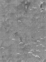
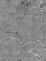
I updated my map with the parachute images. The sol dates might be one sol out depending on exact timing. The sol 56 marker is where I think the approach Hazcam image was taken, but only an approximate location.
Phil
-------------------- ... because the Solar System ain't gonna map itself.
Also to be found posting similar content on https://mastodon.social/@PhilStooke Maps for download (free PDF: https://upload.wikimedia.org/wikipedia/comm...Cartography.pdf NOTE: everything created by me which I post on UMSF is considered to be in the public domain (NOT CC, public domain) |
|
|
|
|
|
|
Jul 16 2021, 09:07 PM
Post
#18
|
||
 Member Group: Members Posts: 349 Joined: 20-June 07 From: Slovenia Member No.: 2461 |
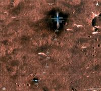
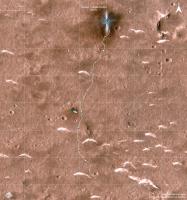
As usual Phil beat me to the update, bur anyway here is my take, color version. Track total is about 420m. |
|
|
|
|
|
|
Jul 16 2021, 09:54 PM
Post
#19
|
|
|
Solar System Cartographer Group: Members Posts: 10227 Joined: 5-April 05 From: Canada Member No.: 227 |
You are doing some really nice work here - for all missions! Thanks.
Phil -------------------- ... because the Solar System ain't gonna map itself.
Also to be found posting similar content on https://mastodon.social/@PhilStooke Maps for download (free PDF: https://upload.wikimedia.org/wikipedia/comm...Cartography.pdf NOTE: everything created by me which I post on UMSF is considered to be in the public domain (NOT CC, public domain) |
|
|
|
|
Jul 18 2021, 07:43 PM
Post
#20
|
|
|
Member Group: Members Posts: 349 Joined: 20-June 07 From: Slovenia Member No.: 2461 |
Thanks Phil. Means a lot. In fact you just gave me an idea to add the fourth one. See Exomars thread post #570.
|
|
|
|
|
Jul 19 2021, 06:31 PM
Post
#21
|
||
|
Solar System Cartographer Group: Members Posts: 10227 Joined: 5-April 05 From: Canada Member No.: 227 |
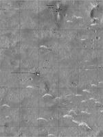
I just had an interesting and very welcome email from a reader of the forum who corrected me on my estimated sol numbers. I have updated my map with the corrected numbers and added an approximate location near the second dune - I am not sure which sol the rover arrived near that dune but we may know it after new images are released.
Corrections are always welcome - we really need as many eyes on this as possible. Phil
-------------------- ... because the Solar System ain't gonna map itself.
Also to be found posting similar content on https://mastodon.social/@PhilStooke Maps for download (free PDF: https://upload.wikimedia.org/wikipedia/comm...Cartography.pdf NOTE: everything created by me which I post on UMSF is considered to be in the public domain (NOT CC, public domain) |
|
|
|
|
|
|
Jul 23 2021, 07:13 AM
Post
#22
|
||
|
Solar System Cartographer Group: Members Posts: 10227 Joined: 5-April 05 From: Canada Member No.: 227 |
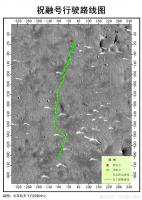
The Chinese map I linked to in the main thread lets me improve my map.
Phil
-------------------- ... because the Solar System ain't gonna map itself.
Also to be found posting similar content on https://mastodon.social/@PhilStooke Maps for download (free PDF: https://upload.wikimedia.org/wikipedia/comm...Cartography.pdf NOTE: everything created by me which I post on UMSF is considered to be in the public domain (NOT CC, public domain) |
|
|
|
|
|
|
Jul 31 2021, 07:21 AM
Post
#23
|
||
|
Solar System Cartographer Group: Members Posts: 10227 Joined: 5-April 05 From: Canada Member No.: 227 |
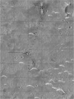
My best guess for sol 75 would be right at the bottom of my map.
The query after 'c. 72' is for the date. The location is good. Phil
-------------------- ... because the Solar System ain't gonna map itself.
Also to be found posting similar content on https://mastodon.social/@PhilStooke Maps for download (free PDF: https://upload.wikimedia.org/wikipedia/comm...Cartography.pdf NOTE: everything created by me which I post on UMSF is considered to be in the public domain (NOT CC, public domain) |
|
|
|
|
|
|
Aug 1 2021, 10:52 AM
Post
#24
|
||
|
Member Group: Members Posts: 349 Joined: 20-June 07 From: Slovenia Member No.: 2461 |
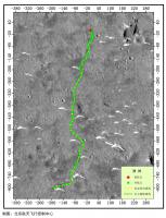
Tentative sol 75 update. I left the dates out, because I'm not sure whether UTC or Chinese time is used for counting. I also improved on base HiRise image, although color balance is hard with these images. Total track is 708 meters in length. |
|
|
|
|
|
|
Aug 17 2021, 08:30 PM
Post
#25
|
|
 Senior Member Group: Members Posts: 1452 Joined: 26-July 08 Member No.: 4270 |
-------------------- -- Hungry4info (Sirius_Alpha)
|
|
|
|
|
Aug 19 2021, 05:26 AM
Post
#26
|
|
|
Senior Member Group: Members Posts: 3008 Joined: 30-October 04 Member No.: 105 |
I give them passing marks on autonomous driving (or for careful directed driving).
--Bill -------------------- |
|
|
|
|
Aug 20 2021, 05:15 PM
Post
#27
|
|
|
Member Group: Members Posts: 109 Joined: 25-November 04 From: Dublin, Ireland Member No.: 113 |
QUOTE (Phil Stooke @ May 22 2021, 07:14 PM)  ....... The landing site is very close to the center of that ellipse and about 40 km from the initial site. Phil [attachment=47933:ellipses.jpg] Phil: I am really struggling to reconcile the scale bar in this scene with everything else I have seen. 40 km between the dots is not what the scalebar says? Am I right? All of which is interesting because I simply don't understand why they didn't go north. If "dot-to-dot" is 40 km, then the prominent pitted cone to the NW is barely 10 km away, whereas the cones to the south are at least 20 km away, maybe a good bit more. This stuff is way beyond my payscale: can anyone show a wider regional map with distances to key features, compared to the total traverse so far? I realise "Why didn't they go North" is a different topic, but IMHO it has to begin with scale comparisons of other target options in the scene. We should have a HiRISE DTM of the landing site area very soon, but I am very sensitive to the fact that people who might like to weigh in here are being very *very* careful in order (I assume) to preserve valuable contacts in Utopia! |
|
|
|
|
Aug 21 2021, 01:32 AM
Post
#28
|
|
|
Solar System Cartographer Group: Members Posts: 10227 Joined: 5-April 05 From: Canada Member No.: 227 |
You are right, it should be more like 30 km between dots. I don't remember where the 40 km came from but it doesn't match the map. I might have been quoting some other source or just put too much Baileys on my cornflakes that morning.
I think they want to use the ground-penetrating radar on a trough about 1700 m south of the current position, which would be an interesting thing to do. Then keep going that way and hope to reach a cone. Phil -------------------- ... because the Solar System ain't gonna map itself.
Also to be found posting similar content on https://mastodon.social/@PhilStooke Maps for download (free PDF: https://upload.wikimedia.org/wikipedia/comm...Cartography.pdf NOTE: everything created by me which I post on UMSF is considered to be in the public domain (NOT CC, public domain) |
|
|
|
|
Aug 30 2021, 10:29 AM
Post
#29
|
|
|
Senior Member Group: Members Posts: 1452 Joined: 26-July 08 Member No.: 4270 |
-------------------- -- Hungry4info (Sirius_Alpha)
|
|
|
|
|
Aug 30 2021, 05:41 PM
Post
#30
|
|
|
Solar System Cartographer Group: Members Posts: 10227 Joined: 5-April 05 From: Canada Member No.: 227 |
This map is very useful, but I am intrigued to find that it does not overlay the new orbiter image of the track very precisely. I will wait until we have a new HiRISE image before updating my map. The orbiter image was taken on 24 August and this map matches that except for the last point, so this map was probably made with data up to 23 August, a week prior to release.
Phil -------------------- ... because the Solar System ain't gonna map itself.
Also to be found posting similar content on https://mastodon.social/@PhilStooke Maps for download (free PDF: https://upload.wikimedia.org/wikipedia/comm...Cartography.pdf NOTE: everything created by me which I post on UMSF is considered to be in the public domain (NOT CC, public domain) |
|
|
|
|

|
Lo-Fi Version | Time is now: 24th September 2024 - 10:40 PM |
|
RULES AND GUIDELINES Please read the Forum Rules and Guidelines before posting. IMAGE COPYRIGHT |
OPINIONS AND MODERATION Opinions expressed on UnmannedSpaceflight.com are those of the individual posters and do not necessarily reflect the opinions of UnmannedSpaceflight.com or The Planetary Society. The all-volunteer UnmannedSpaceflight.com moderation team is wholly independent of The Planetary Society. The Planetary Society has no influence over decisions made by the UnmannedSpaceflight.com moderators. |
SUPPORT THE FORUM Unmannedspaceflight.com is funded by the Planetary Society. Please consider supporting our work and many other projects by donating to the Society or becoming a member. |
|