Ingenuity- Mars 2020 Helicopter, Deployment & Operations |

  |
Ingenuity- Mars 2020 Helicopter, Deployment & Operations |
 Nov 9 2021, 01:54 AM Nov 9 2021, 01:54 AM
Post
#526
|
|
 Member  Group: Members Posts: 444 Joined: 1-July 05 From: New York City Member No.: 424 |
Aha, I had leapt to the conclusion that it would have taken several months for the solar panel to accumulate so much dust, and thus that it was a more recent image. And I was a little puzzled that Mastcam-z could take such a clear image, even with its more powerful lens, in light of the distance that Ingenuity is kept from the rover
Thanks for clearing that up. And I guess now I do more or less recall that image, or a similar one, except that I had forgotten that the solar panel was so dusty so early, before <google, google> the blades had been spun for the first time, which I see happened on Sol 48. |
 |
 
|
|
Nov 17 2021, 09:24 PM
Post
#527
|
||
 Member Group: Members Posts: 670 Joined: 9-May 21 From: Germany Member No.: 9017 |
Sol 254 helicopter color photos have just arrived. Here is one of them (with enhanced colors).
|
|
|
|
|
|
|
Nov 18 2021, 08:29 AM
Post
#528
|
|
 Member Group: Members Posts: 810 Joined: 3-June 04 From: Brittany, France Member No.: 79 |
Pictures taken by RTE camera during Flight 15 (sol 254). Distorsion, vignetting and color balance corrected.
         
-------------------- |
|
|
|
|
Nov 27 2021, 02:27 PM
Post
#529
|
||
|
Junior Member Group: Members Posts: 91 Joined: 11-August 21 Member No.: 9072 |
Sorry for asking, but I promised to answer the request published by the Wikipedia member at the Ingenuity page. As far as I remember the ICAO/USAF alphabet (alpha-bravo-charlie
up to yankee-zulu), the next letter after 'hotel' is 'india', not 'juliet'.
However entry 16 in the https://mars.nasa.gov/technology/helicopter/#Flight-Log names the landing site Airfield J. Should it be interpreted as a misprint or as a reserve for a backward renaming of some of the most distant of three Airfield Hs? 
Attached thumbnail(s)
|
|
|
|
|
|
|
Nov 27 2021, 03:46 PM
Post
#530
|
|
 Senior Member Group: Members Posts: 4247 Joined: 17-January 05 Member No.: 152 |
Maybe they're avoiding I and O to avoid confusion with 1 and 0?
|
|
|
|
|
Nov 27 2021, 05:12 PM
Post
#531
|
||
|
Junior Member Group: Members Posts: 91 Joined: 11-August 21 Member No.: 9072 |
QUOTE (fredk @ Nov 27 2021, 06:46 PM)  Maybe they're avoiding I and O to avoid confusion with 1 and 0? I am sorry, but I must argue your hypothesis. I would not mention ICAO and USAF if I haven't remembered from the end of 70-ies the area codes for some airfields including 4-letter military like EDAR (Ramstein), EDAF (Rhein-Main etc.) - and it was 20 years before the electronic age started. Anyway, up to present:
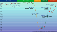
Since Wright Brothers airfield is ICAO-acknowleded as JZRO (both 'J' and 'O' are present), I assume they shall not make exclusions from the airfield naming standards. Either, if there are any doubts, the practice of non-customizable vehicle registration plates is to exclude both ambiguous local alphabet letters, like Ш and Щ (derivatives from the Hebrew 'shin', ש) in Ukraine and other countries using the Cyrillic alphabet. In this case both 'I' and 'J' should be excluded from the set. UPD forward: Dear Floyd, I acknowledge your answer as well, but sorry for not answering you in a separate post. I don't want to be the reason of discussion. I brought here the question from a Wikipedia member with the only fair intention to verify whether "J" was a misprint or there were another reasons for omitting "I". Maybe I was politically wrong in unwrapping the arguments of fredk, but his statement ended with the question mark, so this was a hypothesis and I had to put forward my grounds for not accepting it. At this point I stop here. My version of misprint is supported with another, more seriuos 'misprint' which everybody may find on the screenshot from the NASA's 'Flight log' page. I kindly ask anybody who is sure that "J" was used intentionally to write his answer in Wikipedia at this link https://en.wikipedia.org/wiki/Talk:Ingenuity_(helicopter). No registration required. Thank everybody for their attention and patience. To end this dialogue with something positive allow me to present you one of my last works for wiki. Direct link is Perseverance_route_elevation_profile_sols_1239.png Thank you again, Cherurbino
Attached thumbnail(s)
|
|
|
|
|
|
|
Nov 27 2021, 08:53 PM
Post
#532
|
|
|
Member Group: Members Posts: 910 Joined: 4-September 06 From: Boston Member No.: 1102 |
I'm with Fredk. I often avoid symbols that are poorly differentiated in sans serf fonts. For writing up scientific research, I teach my students to to make integers and letters all differentiable even if scribbled. You don't want to confuse a 2 and a 7 or a 6 and a 0.
-------------------- |
|
|
|
|
Nov 30 2021, 08:03 PM
Post
#533
|
||
|
Member Group: Members Posts: 670 Joined: 9-May 21 From: Germany Member No.: 9017 |
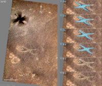
Some more thoughts and calculations regarding the enigmatic X-shaped shadow effect first mentioned in post #442 and discussed in subsequent posts.
If it has something to do with sunlight, it could be helpful to know the displacement of the helicopters shadow with time before take-off. The X is faintly visible on airfield G in the first color photo of the helicopters 11th flight. Some features visible in this photo could be correlated with features in the HiRISE map. This allowed to orientate Ingenuity's color image. The dark shadow of flying helicopter and the X were used to scale the image. The elevation and azimuth of the sun at the location and time were calculated by coding the algorithm from "Mars24 Sunclock Time on Mars. Algorithm and Worked Examples" and an algorithm for the Julian Day number (link). The timeline in the image below shows the shift of the shadow (blue) with time. The X is marked wit a white outline. T is the time of helicopter take-off on sol 163. Already at T - 1 h there is a significant difference between the current shadow and the X, that means, the X remembers Ingenuity's shadow only shortly before take-off, presumably within less than 15 minutes. Any process connected with sunlight should be a short-time process (within a few minutes), and should be reversible, like tenebrescence, in which a mineral like hackmanite changes color upon exposure to ultraviolet light. Frost can most likely be ruled out due to the short-term effects of shifting sunlight and shade. The actual reason for the X remains still unknown.
A similar shadow effect could not be detected at any other airfield. Something seems to be special about airfield G. |
|
|
|
|
|
|
Nov 30 2021, 10:29 PM
Post
#534
|
|
|
Senior Member Group: Members Posts: 1044 Joined: 17-February 09 Member No.: 4605 |
Possibly an electrostatic phenomena. Theoretically interaction between Ingenuity's blades and atmospheric dust will result in a significant charge in the vehicle during operation and once landed there would be an interaction between Ingenuity and charged particles on the surface. From the image, possibly clearing light dust from underlying rock.
The possibility of rotor tribocharging was raised by Farrell et al https://arxiv.org/ftp/arxiv/papers/2102/2102.04181.pdf |
|
|
|
|
Dec 1 2021, 12:07 AM
Post
#535
|
|
|
Senior Member Group: Members Posts: 4247 Joined: 17-January 05 Member No.: 152 |
QUOTE (tau @ Nov 30 2021, 09:03 PM) Any process connected with sunlight should be a short-time process (within a few minutes) Yeah, that's consistent with the sharpness of the X as seen in the navcams just after takeoff. With a longer-timescale process the X should be visibly smeared in the direction of motion of the shadow. Thanks for the shadow analysis!QUOTE (serpens @ Nov 30 2021, 11:29 PM) an interaction between Ingenuity and charged particles on the surface. I can't see an electrostatic interaction between the rotors and ground producing a sharp shadow, unless sunlight (or lack of it) was also involved.
|
|
|
|
|
Dec 1 2021, 06:54 AM
Post
#536
|
||
|
Junior Member Group: Members Posts: 91 Joined: 11-August 21 Member No.: 9072 |
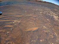
What was the reason for taking this ground photo by RTE on November 15, 2021 (sol 263 of the Perseverance rover mission), i.e. between the flights 15 and 16?
Stored at https://mars.nasa.gov/mars2020/multimedia/r...LI00000_000085J
Attached thumbnail(s)
|
|
|
|
|
|
|
Dec 1 2021, 09:01 PM
Post
#537
|
||
|
Member Group: Members Posts: 670 Joined: 9-May 21 From: Germany Member No.: 9017 |
QUOTE (serpens @ Nov 30 2021, 11:29 PM) Possibly an electrostatic phenomena. Theoretically interaction between Ingenuity's blades and atmospheric dust will result in a significant charge in the vehicle during operation and once landed there would be an interaction between Ingenuity and charged particles on the surface. From the image, possibly clearing light dust from underlying rock. . . . The electric field has the property of superposition, that means, the field around a charged body is the sum of the individual fields of the charged point sources that make up the body. Let us imagine for a moment that an elevated charged body can produce a shadow-like electric field beneath it on the ground. This would necessarily require that a charged point source located above the ground has field lines that converge at the nadir point on the ground. In reality, the field around a point source looks like in the figure below. I calculated the electric potential (stepwise gray in the picture) using formula 4.55 in Example 1 of "Electrostatics of Dielectrics" by E.Y. Tsymbal. The black lines are electric field lines iteratively calculated as lines following the gradient of the potential. A value of 5 was used for the relative dielectric constant of the ground. The general pattern of the field lines does not change significantly for other values. The strength of the field is proportional to the density of the lines. We see that the strength is much lower on the ground than around the point source and decreases smoothly with distance. Thus, a fairly sharp "electrostatic image" on the ground caused by charged rotor blades can be ruled out.
|
|
|
|
|
|
|
Dec 1 2021, 10:21 PM
Post
#538
|
|
|
Senior Member Group: Members Posts: 1044 Joined: 17-February 09 Member No.: 4605 |
The charge on Ingenuity would be a distributed source rather than a single point source with spreading spherical attenuation. Charged dust particles on the ground having the same polarity would be repelled. The field strength would be subject to the standard variables of distance, permeability etc and a basic visualisation would be field vectors between two plates of different size with the same polarity. So the interaction with charged dust particles on the ground would pretty much reflect Ingenuity's configuration and repelling the dust would change the albedo. The force would be weak but the dust particles are minuscule. Just one possibility as an alternative to the influence of ingenuity's shadow.
|
|
|
|
|
Dec 2 2021, 01:05 AM
Post
#539
|
|
|
Solar System Cartographer Group: Members Posts: 10166 Joined: 5-April 05 From: Canada Member No.: 227 |
I don't find any of the explanations very convincing. Why don't these effects occur at other sites? I expect someone is looking at it, and it's possible that the unusual image taken on the surface on sol 263 was part of an investigation.
Phil -------------------- ... because the Solar System ain't gonna map itself.
Also to be found posting similar content on https://mastodon.social/@PhilStooke Maps for download (free PD: https://upload.wikimedia.org/wikipedia/comm...Cartography.pdf NOTE: everything created by me which I post on UMSF is considered to be in the public domain (NOT CC, public domain) |
|
|
|
|
Dec 2 2021, 12:23 PM
Post
#540
|
|
 Senior Member Group: Members Posts: 2429 Joined: 30-January 13 From: Penang, Malaysia. Member No.: 6853 |
QUOTE (Cherurbino @ Dec 1 2021, 02:54 PM) What was the reason for taking this ground photo by RTE on November 15, 2021 (sol 263 of the Perseverance rover mission), i.e. between the flights 15 and 16? Maybe it's a new campaign to get a better understanding of the terrain at the landing site? Another RTE was acquired a few sols after Flight 16 on sol 274... https://mars.nasa.gov/mars2020-raw-images/p...0_000085J01.png |
|
|
|
|

|
Lo-Fi Version | Time is now: 23rd May 2024 - 02:35 PM |
|
RULES AND GUIDELINES Please read the Forum Rules and Guidelines before posting. IMAGE COPYRIGHT |
OPINIONS AND MODERATION Opinions expressed on UnmannedSpaceflight.com are those of the individual posters and do not necessarily reflect the opinions of UnmannedSpaceflight.com or The Planetary Society. The all-volunteer UnmannedSpaceflight.com moderation team is wholly independent of The Planetary Society. The Planetary Society has no influence over decisions made by the UnmannedSpaceflight.com moderators. |
SUPPORT THE FORUM Unmannedspaceflight.com is funded by the Planetary Society. Please consider supporting our work and many other projects by donating to the Society or becoming a member. |
|