MSL Route Map |

  |
MSL Route Map |
 Jan 4 2022, 01:14 PM Jan 4 2022, 01:14 PM
Post
#1636
|
|||
 Member  Group: Members Posts: 349 Joined: 20-June 07 From: Slovenia Member No.: 2461 |
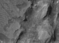
Sol 3345 update
RGB color version |
||
 |
 
|
||
|
Jan 4 2022, 11:41 PM
Post
#1637
|
||
 Senior Member Group: Members Posts: 2429 Joined: 30-January 13 From: Penang, Malaysia. Member No.: 6853 |
QUOTE (nogal @ Jan 4 2022, 04:35 AM)  Sol 3345 drive. The first drive of the year, of about 30m, took Curiosity to a new quadrangle (name to be made public soon, hopefully). Fernando The new quadrangle name is 'Roraima'. Its named after the northern-most state of Brazil and Mount Roraima. The terrain in the Roraima region on Earth is similar to this area on Mars flat-topped hills and some steep slopes. Refer to: https://mars.nasa.gov/msl/mission-updates/9...indo-a-roraima/
|
|
|
|
|
|
|
Jan 5 2022, 07:57 PM
Post
#1638
|
||
|
Member Group: Members Posts: 349 Joined: 20-June 07 From: Slovenia Member No.: 2461 |
Sol 3347 update |
|
|
|
|
|
|
Jan 5 2022, 09:37 PM
Post
#1639
|
||
 Member Group: Members Posts: 907 Joined: 15-June 09 From: Lisbon, Portugal Member No.: 4824 |
Sol 3347. A drive to the south of about 14m through terrain "with limited visibility".
I will add the name "Mirador" (Lookout point) when I'm able to conclusively locate the "distant butte" it refers to.
Path data source: JPL/NASA. Fernando _____________________________________________________________________ The Martian Way files can also be downloaded from: https://drive.google.com/drive/folders/1OJH...BbQ?usp=sharing Included are "The Martian Way" KMZ file, User's Guide, and MSL Orbital map of Gale crater. |
|
|
|
|
|
|
Jan 6 2022, 11:22 AM
Post
#1640
|
||
|
Member Group: Members Posts: 349 Joined: 20-June 07 From: Slovenia Member No.: 2461 |
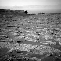
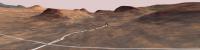
Real climbing ahead. Perspective view of Curiosity on sol 3347. |
|
|
|
|
|
|
Jan 7 2022, 04:24 AM
Post
#1641
|
|
|
Senior Member Group: Members Posts: 2429 Joined: 30-January 13 From: Penang, Malaysia. Member No.: 6853 |
QUOTE (kymani76 @ Jan 6 2022, 07:22 PM) Real climbing ahead. Perspective view of Curiosity on sol 3347. Do you have any estimates for the heights of the buttes around the rover? |
|
|
|
|
Jan 7 2022, 06:35 AM
Post
#1642
|
||
|
Founder Group: Chairman Posts: 14432 Joined: 8-February 04 Member No.: 1 |
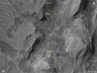
I took Fred & Tims maps from http://bit.ly/MSL_Basemap and via QGIS made a few maps that'll let you read out the altitude of the nearby topography. For what it's worth I think the largest butte due south of the rover right now is ~53 meters to the top from the current location and ~40m from its base to the top.
Threw some more maps here : https://dougellison.smugmug.com/Projects/Gale-Maps/
Attached thumbnail(s)
|
|
|
|
|
|
|
Jan 7 2022, 07:45 AM
Post
#1643
|
||
|
Member Group: Members Posts: 349 Joined: 20-June 07 From: Slovenia Member No.: 2461 |
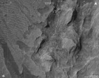
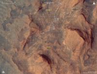
QUOTE (PaulH51 @ Jan 7 2022, 05:24 AM) Do you have any estimates for the heights of the buttes around the rover? Yes of course I do. Here is a map with absolute elevations in meters:
|
|
|
|
|
|
|
Jan 7 2022, 07:58 AM
Post
#1644
|
||
|
Member Group: Members Posts: 349 Joined: 20-June 07 From: Slovenia Member No.: 2461 |
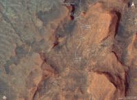
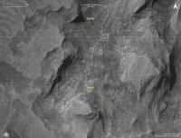
..and version with elevations expressed as heights above ground:
The tallest butte in this view is about 18 meters in height (measured from its base). |
|
|
|
|
|
|
Jan 7 2022, 11:21 AM
Post
#1645
|
|
|
Senior Member Group: Members Posts: 2429 Joined: 30-January 13 From: Penang, Malaysia. Member No.: 6853 |
thanks guys
 Much appreciated Much appreciated
|
|
|
|
|
Jan 7 2022, 04:02 PM
Post
#1646
|
|
 Senior Member Group: Members Posts: 4247 Joined: 17-January 05 Member No.: 152 |
QUOTE (kymani76 @ Jan 7 2022, 08:58 AM) heights above ground I'm curious exactly what you did there - you've clearly not just subtracted a fixed offset elevation. Maybe you subtracted the elevation map smoothed over some horizontal scale? What scale did you use? |
|
|
|
|
Jan 7 2022, 08:26 PM
Post
#1647
|
||
|
Member Group: Members Posts: 349 Joined: 20-June 07 From: Slovenia Member No.: 2461 |
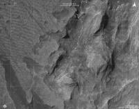
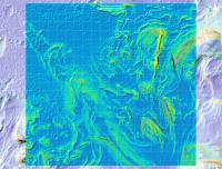
QUOTE (fredk @ Jan 7 2022, 05:02 PM) I'm curious exactly what you did there I used a common Lidar processing technique. I took the HiRise Gale crater DEM and created new raster where relative heights (or prominences) to the base ground are calculated. It's usually used to measure building and treetop heights here on Earth, but can also be used to measure ridges, or as in this case buttes on Mars. I found a nice graphical explanation explaining the procedure here. And here is resulting map, where slope raster is combined with height above ground raster for the current Curiosity's location:
Hope this helps, Jaka |
|
|
|
|
|
|
Jan 7 2022, 08:29 PM
Post
#1648
|
|
|
Senior Member Group: Members Posts: 3516 Joined: 4-November 05 From: North Wales Member No.: 542 |
It is great to see these maps with elevation contours added. Thanks so much for posting them. Is there any chance that this could become a standard feature of the route maps?
|
|
|
|
|
Jan 7 2022, 08:45 PM
Post
#1649
|
||
|
Member Group: Members Posts: 349 Joined: 20-June 07 From: Slovenia Member No.: 2461 |
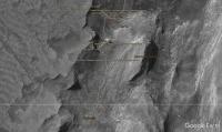
Curiosity moved another 40 meters to the south on sol 3349. |
|
|
|
|
|
|
Jan 7 2022, 08:57 PM
Post
#1650
|
||
|
Member Group: Members Posts: 349 Joined: 20-June 07 From: Slovenia Member No.: 2461 |
QUOTE (ngunn @ Jan 7 2022, 09:29 PM) Is there any chance that this could become a standard feature of the route maps?
As requested..map update with contours present, for now in BW only, color image still needs some alignment work. |
|
|
|
|
|
|

|
Lo-Fi Version | Time is now: 24th May 2024 - 06:32 AM |
|
RULES AND GUIDELINES Please read the Forum Rules and Guidelines before posting. IMAGE COPYRIGHT |
OPINIONS AND MODERATION Opinions expressed on UnmannedSpaceflight.com are those of the individual posters and do not necessarily reflect the opinions of UnmannedSpaceflight.com or The Planetary Society. The all-volunteer UnmannedSpaceflight.com moderation team is wholly independent of The Planetary Society. The Planetary Society has no influence over decisions made by the UnmannedSpaceflight.com moderators. |
SUPPORT THE FORUM Unmannedspaceflight.com is funded by the Planetary Society. Please consider supporting our work and many other projects by donating to the Society or becoming a member. |
|