Finishing work in and around Seitah, sols 238-378 |

  |
Finishing work in and around Seitah, sols 238-378 |
 Jan 26 2022, 04:07 PM Jan 26 2022, 04:07 PM
Post
#211
|
|||
 Member  Group: Members Posts: 670 Joined: 9-May 21 From: Germany Member No.: 9017 |
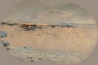
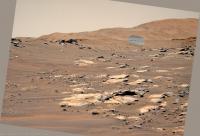
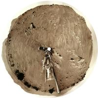
Sol 328 SuperCam Remote Micro-Imager of delta cliffs with a "marsonaut" for scale and a sol 308 Mastcam-Z context.
The images were aligned horizontally. The layered outcrops to the right on the talus have a dip angle of at least 20° or more, depending on how they are cut at the surface.
|
||
 |
 
|
||
|
Jan 26 2022, 04:10 PM
Post
#212
|
|||
|
Member Group: Members Posts: 670 Joined: 9-May 21 From: Germany Member No.: 9017 |
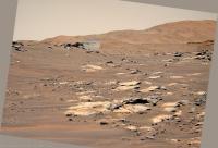
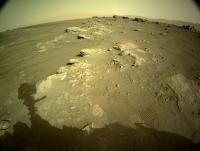
Sol 331 SuperCam Remote Micro-Imager of layered delta (or river) sediment outcrops with two "marsonauts" for scale and a sol 308 Mastcam-Z context.
The images were aligned horizontally. The distant marsonaut stands at a small crater on the inner wall of the Jezero crater.
|
||
|
|
|
||
|
Jan 28 2022, 03:23 AM
Post
#213
|
||
|
Solar System Cartographer Group: Members Posts: 10166 Joined: 5-April 05 From: Canada Member No.: 227 |
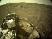
Sol 333, a small drive up onto the ledge, now facing the sampled block for another attempt.
Phil
-------------------- ... because the Solar System ain't gonna map itself.
Also to be found posting similar content on https://mastodon.social/@PhilStooke Maps for download (free PD: https://upload.wikimedia.org/wikipedia/comm...Cartography.pdf NOTE: everything created by me which I post on UMSF is considered to be in the public domain (NOT CC, public domain) |
|
|
|
|
|
|
Jan 29 2022, 09:05 AM
Post
#214
|
||||||
 Senior Member Group: Members Posts: 2429 Joined: 30-January 13 From: Penang, Malaysia. Member No.: 6853 |
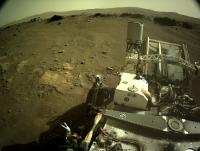
A small readjustment on sol 335: 4-tile NavCam's assembled in ICE - Raw colours
|
|||||
|
|
|
|||||
|
Jan 30 2022, 12:26 PM
Post
#215
|
|||
|
Member Group: Members Posts: 670 Joined: 9-May 21 From: Germany Member No.: 9017 |
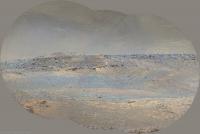
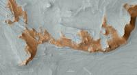
A compilation of SuperCam RMI images of the delta cliffs from sol 306 to sol 331 in a Mastcam-Z context panorama and a HiRISE map.
Areas not visible from the rover position are grayed out in the HiRISE map. The contour interval is 2 m.
Links to individual high-resolution SuperCam mosaics and posts: (Note: the first six mosaics are not rotated to the horizontal) sol 306 mosaic / post #150 (no cliff) sol 315 mosaic / post #162 sol 316 mosaic / post #164 sol 320 mosaic / post #177 sol 323 no. 1 mosaic / post #187 sol 323 no. 2 mosaic / post #188 sol 315+323 mosaic / post #191 sol 325 mosaic / post #194 sol 328 mosaic / post #211 sol 331 mosaic / post #212 |
||
|
|
|
||
|
Jan 30 2022, 10:15 PM
Post
#216
|
||
|
Solar System Cartographer Group: Members Posts: 10166 Joined: 5-April 05 From: Canada Member No.: 227 |
Tau, your work is amazing and very useful.
Sol 335, moving to get a better position for sampling. Phil
-------------------- ... because the Solar System ain't gonna map itself.
Also to be found posting similar content on https://mastodon.social/@PhilStooke Maps for download (free PD: https://upload.wikimedia.org/wikipedia/comm...Cartography.pdf NOTE: everything created by me which I post on UMSF is considered to be in the public domain (NOT CC, public domain) |
|
|
|
|
|
|
Jan 31 2022, 02:59 AM
Post
#217
|
||
|
Senior Member Group: Members Posts: 1074 Joined: 21-September 07 From: Québec, Canada Member No.: 3908 |
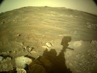
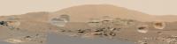
Sol 333 Lmastcam-Z:
|
|
|
|
|
|
|
Jan 31 2022, 03:44 PM
Post
#218
|
||
|
Member Group: Members Posts: 670 Joined: 9-May 21 From: Germany Member No.: 9017 |
Thank you, Phil, for your motivating and encouraging words.
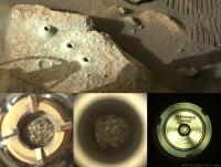
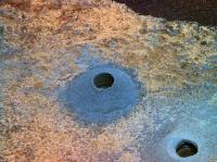
On sol 337, the third coring attempt on the same rock appears to have been successfully completed:
|
|
|
|
|
|
|
Feb 3 2022, 01:04 PM
Post
#219
|
||
|
Senior Member Group: Members Posts: 2429 Joined: 30-January 13 From: Penang, Malaysia. Member No.: 6853 |
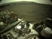
Looks like a long drive on sol 340
4-tile NavCam looking back after the drive The low sun caused a few exposure issues, but I still like the resulting mosaic (roughly assembled in MS-ICE)
|
|
|
|
|
|
|
Feb 3 2022, 01:37 PM
Post
#220
|
|||||
|
Member Group: Members Posts: 670 Joined: 9-May 21 From: Germany Member No.: 9017 |
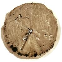
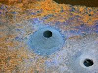
The third drill hole seen by Mastcam-Z on sol 339
1. Left eye f = 110 mm filter 0 (RGB) raw image 2. Left eye filters 1 to 6 principal components false colors 3. Right eye filters 1 to 6 (infrared) principal components false colors Interestingly, the drill tailings of the hole drilled on sol 306 have changed their multispectral color (dust from the dust storm?, aging of fresh surfaces?) 4. f = 34 mm anaglyph with discarded pieces of the second core 1 .
|
||||
|
|
|
||||
|
Feb 4 2022, 01:09 AM
Post
#221
|
||
|
Solar System Cartographer Group: Members Posts: 10166 Joined: 5-April 05 From: Canada Member No.: 227 |
Sol 340, the long drive Paul mentioned brings us to this spot. This could be the longest drive of the mission so far but I won't speculate about the exact length.
This panorama was very tricky. I don't really have time to do this but it's addictive. Phil
-------------------- ... because the Solar System ain't gonna map itself.
Also to be found posting similar content on https://mastodon.social/@PhilStooke Maps for download (free PD: https://upload.wikimedia.org/wikipedia/comm...Cartography.pdf NOTE: everything created by me which I post on UMSF is considered to be in the public domain (NOT CC, public domain) |
|
|
|
|
|
|
Feb 4 2022, 01:51 AM
Post
#222
|
|
|
Senior Member Group: Members Posts: 2429 Joined: 30-January 13 From: Penang, Malaysia. Member No.: 6853 |
JSON and GeoJSON are now reporting the length as 237.78 meters, so looks like a Mars rover record.
What is the longest drive on the Moon? Is it a solar system record?  Glad you still find time to do those circular pans, all I can do is the 5 individual NavCam 4-tile mosaics, the 360 pan is way beyond my skillset... QUOTE (Phil Stooke @ Feb 4 2022, 09:09 AM)  Sol 340, the long drive Paul mentioned brings us to this spot. This could be the longest drive of the mission so far but I won't speculate about the exact length. This panorama was very tricky. I don't really have time to do this but it's addictive. Phil |
|
|
|
|
Feb 4 2022, 03:27 AM
Post
#223
|
|
|
Solar System Cartographer Group: Members Posts: 10166 Joined: 5-April 05 From: Canada Member No.: 227 |
The longest drive on the Moon is tricky because the situations are in no way comparable. Strictly speaking I suppose the longest single uninterrupted drive was from the Apollo 17 lunar module to Station 2 at South Massif on EVA 2, driven by a human (Gene Cernan). For a robotic rover it was 3000 m (approx) during a single work shift for Lunokhod 2, driven using a live TV signal (slow scan but still live). Mars rover drives are all pre-programmed, though Perseverance is making use of advanced autonavigation software which must have been used here. The longest drive in a single sol on Mars before this was 220 m on sol 410 of Opportunity's mission. So this is a new record for Mars.
Phil -------------------- ... because the Solar System ain't gonna map itself.
Also to be found posting similar content on https://mastodon.social/@PhilStooke Maps for download (free PD: https://upload.wikimedia.org/wikipedia/comm...Cartography.pdf NOTE: everything created by me which I post on UMSF is considered to be in the public domain (NOT CC, public domain) |
|
|
|
|
Feb 4 2022, 04:56 AM
Post
#224
|
|
|
Senior Member Group: Members Posts: 2998 Joined: 30-October 04 Member No.: 105 |
QUOTE (Phil Stooke @ Feb 3 2022, 08:09 PM) Sol 340, the long drive Paul mentioned brings us to this spot. This could be the longest drive of the mission so far but I won't speculate about the exact length. This panorama was very tricky. I don't really have time to do this but it's addictive. Phil Interesting that the tracks have a "reflective glint" to them. This impresses me as unusual for Mars. I've seen this on the Moon where the Buggy or Rover compresses the Fairy Castle Structure of the regolith. --Bill -------------------- |
|
|
|
|
Feb 4 2022, 05:02 AM
Post
#225
|
|
|
Senior Member Group: Members Posts: 2998 Joined: 30-October 04 Member No.: 105 |
QUOTE (PaulH51 @ Feb 3 2022, 08:51 PM) JSON and GeoJSON are now reporting the length as 237.78 meters, so looks like a Mars rover record. What is the longest drive on the Moon? Is it a solar system record? I'm looking looking forward to seeing a map position and also getting a LOS connection with Ingenuity again. --Bill -------------------- |
|
|
|
|

|
Lo-Fi Version | Time is now: 24th May 2024 - 07:44 PM |
|
RULES AND GUIDELINES Please read the Forum Rules and Guidelines before posting. IMAGE COPYRIGHT |
OPINIONS AND MODERATION Opinions expressed on UnmannedSpaceflight.com are those of the individual posters and do not necessarily reflect the opinions of UnmannedSpaceflight.com or The Planetary Society. The all-volunteer UnmannedSpaceflight.com moderation team is wholly independent of The Planetary Society. The Planetary Society has no influence over decisions made by the UnmannedSpaceflight.com moderators. |
SUPPORT THE FORUM Unmannedspaceflight.com is funded by the Planetary Society. Please consider supporting our work and many other projects by donating to the Society or becoming a member. |
|