Mro On Approach, TCM-3 not required |

  |
Mro On Approach, TCM-3 not required |
 Feb 16 2006, 03:35 PM Feb 16 2006, 03:35 PM
Post
#16
|
|
 Senior Member  Group: Members Posts: 1465 Joined: 9-February 04 From: Columbus OH USA Member No.: 13 |
I made an animation of the approach through the first orbit:
MRO approach movie (5.7MB MPG file) It's from the point of view of a (fictitious) nadir-pointing camera with the same FOV (1.14 degrees) as HiRISE. -------------------- |
 |
 
|
|
Feb 16 2006, 03:46 PM
Post
#17
|
||
|
Founder Group: Chairman Posts: 14434 Joined: 8-February 04 Member No.: 1 |
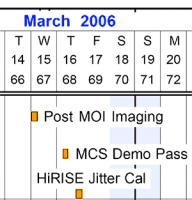
Given the addition of some post-moi-pre-aerobraking imaging, at what appears to be between about 0000 and 0600 on the 15th of March - any idea on a nadir target for that sort of time?
Doug
Attached thumbnail(s)
|
|
|
|
|
|
|
Feb 16 2006, 05:00 PM
Post
#18
|
|
|
Senior Member Group: Members Posts: 1465 Joined: 9-February 04 From: Columbus OH USA Member No.: 13 |
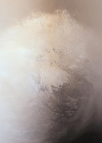
QUOTE (djellison @ Feb 16 2006, 10:46 AM)  Given the addition of some post-moi-pre-aerobraking imaging, at what appears to be between about 0000 and 0600 on the 15th of March - any idea on a nadir target for that sort of time? Doug Looks like it's the north polar ice cap. Here's the view midway in that interval (+ marks the nadir point):  Note that the FOV above is 5 degrees. CTX has an FOV 0f 6 degrees; HiRISE 1.14 degrees. -------------------- |
|
|
|
| Guest_Sunspot_* |
Feb 16 2006, 05:15 PM
Post
#19
|
|
Guests |
I kept reading that they wouldn't be doing any imaging until after aerobraking was complete.. this is good news.
|
|
|
|
|
Feb 16 2006, 05:34 PM
Post
#20
|
|
|
Senior Member Group: Members Posts: 2542 Joined: 13-September 05 Member No.: 497 |
QUOTE (jmknapp @ Feb 16 2006, 09:00 AM) Looks like it's the north polar ice cap. Here's the view midway in that interval (+ marks the nadir point): Try looking (hint, hint) closer to 6:00 UTC. -------------------- Disclaimer: This post is based on public information only. Any opinions are my own.
|
|
|
|
|
Feb 16 2006, 06:03 PM
Post
#21
|
|
|
Senior Member Group: Members Posts: 1465 Joined: 9-February 04 From: Columbus OH USA Member No.: 13 |
QUOTE (mcaplinger @ Feb 16 2006, 12:34 PM) Try looking (hint, hint) closer to 6:00 UTC. Hmmm... here is the view at 0600:  Wondering what you are hinting at--perhaps this is targeted after one of the proposed Phoenix landing sites? The subpoint above is 75N 141W. -------------------- |
|
|
|
|
Feb 16 2006, 06:30 PM
Post
#22
|
|
 Dublin Correspondent Group: Admin Posts: 1799 Joined: 28-March 05 From: Celbridge, Ireland Member No.: 220 |
QUOTE (jmknapp @ Feb 16 2006, 06:03 PM) Wondering what you are hinting at--perhaps this is targeted after one of the proposed Phoenix landing sites? The subpoint above is 75N 141W. Possibly - I had a placeholder for Phoenix @ 70N 120W but I'm not sure where I got that from. I didn't think the precise landing site had been chosen yet though. |
|
|
|
|
Feb 16 2006, 06:49 PM
Post
#23
|
|
|
Solar System Cartographer Group: Members Posts: 10226 Joined: 5-April 05 From: Canada Member No.: 227 |
It wouldn't be targeted, just whatever they are seeing as they pass by.
Phil -------------------- ... because the Solar System ain't gonna map itself.
Also to be found posting similar content on https://mastodon.social/@PhilStooke Maps for download (free PDF: https://upload.wikimedia.org/wikipedia/comm...Cartography.pdf NOTE: everything created by me which I post on UMSF is considered to be in the public domain (NOT CC, public domain) |
|
|
|
|
Feb 16 2006, 07:05 PM
Post
#24
|
|
|
Junior Member Group: Members Posts: 91 Joined: 27-January 05 From: Arlington, Virginia Member No.: 159 |
|
|
|
|
|
Feb 16 2006, 07:10 PM
Post
#25
|
|
|
Senior Member Group: Members Posts: 1636 Joined: 9-May 05 From: Lima, Peru Member No.: 385 |
Below is the Sout Pole Cap that looks different than the Nort Pole Cap. The MRO will orbit around poles?
 A much better resolution and visibilty is below: 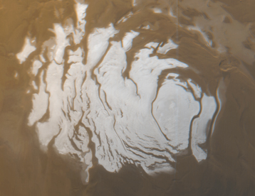 This is the south polar cap of Mars as it appeared to the Mars Global Surveyor (MGS) Mars Orbiter Camera (MOC) on April 17, 2000. In winter and early spring, this entire scene would be covered by frost. In summer, the cap shrinks to its minimum size, as shown here. Even though it is summer, observations made by the Viking orbiters in the 1970s showed that the south polar cap remains cold enough that the polar frost (seen here as white) consists of carbon dioxide. Carbon dioxide freezes at temperatures around -125° C (-193° F). Mid-summer afternoon sunlight illuminates this scene from the upper left from about 11.2° above the horizon. Soon the cap will experience sunsets; by June 2000, this pole will be in autumn, and the area covered by frost will begin to grow. Winter will return to the south polar region in December 2000. The polar cap from left to right is about 420 km (260 mi) across Rodolfo |
|
|
|
|
Feb 16 2006, 08:00 PM
Post
#26
|
|
|
Junior Member Group: Members Posts: 63 Joined: 20-April 05 Member No.: 312 |
|
|
|
|
|
Feb 16 2006, 10:14 PM
Post
#27
|
|
|
Senior Member Group: Members Posts: 2542 Joined: 13-September 05 Member No.: 497 |
QUOTE (jmknapp @ Feb 16 2006, 10:03 AM) Wondering what you are hinting at--perhaps this is targeted after one of the proposed Phoenix landing sites? The subpoint above is 75N 141W. I think your software is confused, or ours is. What SPICE kernel are you using? -------------------- Disclaimer: This post is based on public information only. Any opinions are my own.
|
|
|
|
|
Feb 16 2006, 10:42 PM
Post
#28
|
|
|
Senior Member Group: Members Posts: 1465 Joined: 9-February 04 From: Columbus OH USA Member No.: 13 |
QUOTE (mcaplinger @ Feb 16 2006, 05:14 PM) I think your software is confused, or ours is. What SPICE kernel are you using? Could be. Here are the kernels I'm using: CK: '$KROOT/ck/DESAT_MOI_sc_20060103171803.bc', SPK: '$KROOT/spk/spk_c_tcm1-od006_050812_060315_p-v1.bsp', '$KROOT/spk/spk_moi_lowperf_t2_051123_060320_p-v1.bsp', '$KROOT/spk/spk_moi_ideal_051123_060320_p-v1.bsp', '$KROOT/spk/spk_moi_highperf_t1_051123_060320_p-v1.bsp', I notice there's a big difference whether highperf, ideal or lowperf is used, so maybe that's the difference. The projection above uses highperf (since it's the last listed in the config file). -------------------- |
|
|
|
|
Feb 16 2006, 11:31 PM
Post
#29
|
|
|
Senior Member Group: Members Posts: 2542 Joined: 13-September 05 Member No.: 497 |
QUOTE (jmknapp @ Feb 16 2006, 02:42 PM) I notice there's a big difference whether highperf, ideal or lowperf is used, so maybe that's the difference. The projection above uses highperf (since it's the last listed in the config file). We were doing this planning several weeks ago, so the kernel I used was from mid-January. In those kernels, we were near periapsis at 6:00 UTC. Looks like we're looking at some replanning if the MOI performance makes this much difference. I would try rerunning with ideal and see what that looks like. BTW, what software are you using for this? -------------------- Disclaimer: This post is based on public information only. Any opinions are my own.
|
|
|
|
|
Feb 17 2006, 02:00 AM
Post
#30
|
|
|
Senior Member Group: Members Posts: 1465 Joined: 9-February 04 From: Columbus OH USA Member No.: 13 |
QUOTE (mcaplinger @ Feb 16 2006, 06:31 PM) We were doing this planning several weeks ago, so the kernel I used was from mid-January. In those kernels, we were near periapsis at 6:00 UTC. Looks like we're looking at some replanning if the MOI performance makes this much difference. I would try rerunning with ideal and see what that looks like. BTW, what software are you using for this? Hmmm... using the "ideal" kernel gives periapsis on 15MAR2006 at 06:24UTC, 399km, at 67S 28E, although it's on the night side so the picture is dark. Pretty big difference there. The software I'm using is a C program that I wrote to use the CSPICE library--so there could be a bug or three there. The same program works pretty well with Cassini, but at least in that case I have actual images to compare against for testing. Choice of kernels seems to be a big factor. One kernel tells a cautionary tale: spk_nomoi_051123_060320_p-v1.bsp No MOI--gulp! That pessimistic kernel gives this view on 15MAR: 
-------------------- |
|
|
|
|

|
Lo-Fi Version | Time is now: 23rd September 2024 - 04:13 PM |
|
RULES AND GUIDELINES Please read the Forum Rules and Guidelines before posting. IMAGE COPYRIGHT |
OPINIONS AND MODERATION Opinions expressed on UnmannedSpaceflight.com are those of the individual posters and do not necessarily reflect the opinions of UnmannedSpaceflight.com or The Planetary Society. The all-volunteer UnmannedSpaceflight.com moderation team is wholly independent of The Planetary Society. The Planetary Society has no influence over decisions made by the UnmannedSpaceflight.com moderators. |
SUPPORT THE FORUM Unmannedspaceflight.com is funded by the Planetary Society. Please consider supporting our work and many other projects by donating to the Society or becoming a member. |
|