Caldera 3D |

  |
Caldera 3D |
 Mar 4 2006, 06:51 PM Mar 4 2006, 06:51 PM
Post
#1
|
||||
|
Junior Member  Group: Members Posts: 61 Joined: 5-June 05 From: 46.283N 11.433E :)) Member No.: 401 |
Hi!
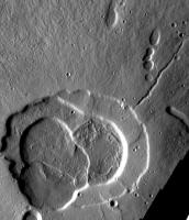
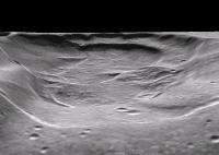
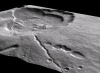
The wonderful caldera on Hecates Tholus summit on themis website suggested me to try a photoclinometry 3D reconstruction.
|
|||
 |
 
|
|||
| Guest_Myran_* |
Mar 27 2006, 08:36 PM
Post
#2
|
|
Guests |
Thats very good, though I dont think the left side came out entirely correct the way it slopes up there, thank you for posting though.

|
|
|
|
|
May 27 2007, 10:50 PM
Post
#3
|
|
|
Member Group: Members Posts: 194 Joined: 8-February 04 Member No.: 10 |
I would like to try this, but I don't know of any such Mac based software. In Photoshop there is an 'emboss' filter which effectively turns a grayscale DEM into a shaded relief map. Can a similar filter be designed that would reverse the process, turning a suitable image showing topography with minimal cast shadows into a rough grayscale DEM? Hand painting such things is a lot of work!
Don |
|
|
|
|

|
Lo-Fi Version | Time is now: 26th September 2024 - 08:54 AM |
|
RULES AND GUIDELINES Please read the Forum Rules and Guidelines before posting. IMAGE COPYRIGHT |
OPINIONS AND MODERATION Opinions expressed on UnmannedSpaceflight.com are those of the individual posters and do not necessarily reflect the opinions of UnmannedSpaceflight.com or The Planetary Society. The all-volunteer UnmannedSpaceflight.com moderation team is wholly independent of The Planetary Society. The Planetary Society has no influence over decisions made by the UnmannedSpaceflight.com moderators. |
SUPPORT THE FORUM Unmannedspaceflight.com is funded by the Planetary Society. Please consider supporting our work and many other projects by donating to the Society or becoming a member. |
|