SMART-1 impact, September 2006 |

  |
SMART-1 impact, September 2006 |
 Aug 10 2006, 03:11 PM Aug 10 2006, 03:11 PM
Post
#31
|
|
|
Senior Member  Group: Members Posts: 2454 Joined: 8-July 05 From: NGC 5907 Member No.: 430 |
Lunar research opportunity
As many of you are aware, the ESA's SMART-1 lunar probe is scheduled to spiral down over the next three weeks, culminating in its impacting the Lunar surface on 3 September 2006. During its descent through the Moon's tenuous atmosphere, our colleague Claudio Maccone has proposed that as many of us as possible monitor its S-band and X-band beacons, to analyze the nature of the Lunar atmosphere through sounding measurements. He has secured time on the 32 metre VLBI antenna in Medicina to support these measurements. I know several of you have been doing Deep Space Network monitoring - now is your chance to make a significant amateur contribution to science. Claudio's research proposal to the Istituto di Radioastronomia appears (in English) at: http://www.setileague.org/articles/maccone.pdf Please take a look, and contact Claudio at the email address (clmaccon@libero.it) with cc to me, if you are able to participate in this important experiment. Thanks. If any of you are in touch with other amateur groups (SARA, ERAC, AMSAT, etc.) that may be interested in monitoring SMART-1, please feel free to cross-post this email to their various Lists. -- H. Paul Shuch, Ph.D. Executive Director Emeritus, The SETI League, Inc. http://www.setileague.org n6tx@setileague.org -------------------- "After having some business dealings with men, I am occasionally chagrined,
and feel as if I had done some wrong, and it is hard to forget the ugly circumstance. I see that such intercourse long continued would make one thoroughly prosaic, hard, and coarse. But the longest intercourse with Nature, though in her rudest moods, does not thus harden and make coarse. A hard, sensible man whom we liken to a rock is indeed much harder than a rock. From hard, coarse, insensible men with whom I have no sympathy, I go to commune with the rocks, whose hearts are comparatively soft." - Henry David Thoreau, November 15, 1853 |
 |
 
|
|
Aug 11 2006, 02:11 PM
Post
#32
|
|
|
Senior Member Group: Members Posts: 2454 Joined: 8-July 05 From: NGC 5907 Member No.: 430 |
NEWS RELEASE
For immediate release: 2006 July 18 For more information -- Glenn A. Walsh: Daytime: E-Mail gawalsh@planetarium.cc Evening: Telephone 412-561-7876 Space Probe Crash on Moon May Be Visible to Amateur Astronomers with Large Telescopes Pittsburgh, July 18 On the evening of September 2, observers in the eastern half of North America with moderately large telescopes may get a chance to see the European SMART-1 spacecraft crash into the Moon, according to Friends of the Zeiss Steering Committee Member Francis G. Graham, who is Assistant Professor of Physics and Astronomy at Kent State University. Professor Graham has prepared a practical guide for amateur observers who wish to try to watch the impact of Smart-1 on the Moon, which can be accessed at the following link: http://www.venustransit.pghfree.net/gcorner/ImpactMoon.htm For further information, the following is contact information for Professor Graham: Francis Graham East Liverpool Regional Campus Kent State University 400 East 4th Street East Liverpool OH 43920 USA Telephone: 330-382-7466 Electronic Mail: fgraham@kent.edu -------------------- "After having some business dealings with men, I am occasionally chagrined,
and feel as if I had done some wrong, and it is hard to forget the ugly circumstance. I see that such intercourse long continued would make one thoroughly prosaic, hard, and coarse. But the longest intercourse with Nature, though in her rudest moods, does not thus harden and make coarse. A hard, sensible man whom we liken to a rock is indeed much harder than a rock. From hard, coarse, insensible men with whom I have no sympathy, I go to commune with the rocks, whose hearts are comparatively soft." - Henry David Thoreau, November 15, 1853 |
|
|
|
| Guest_DonPMitchell_* |
Aug 11 2006, 07:29 PM
Post
#33
|
|
Guests |
QUOTE (tedstryk @ Aug 7 2006, 08:48 AM)  I am assuming you mean plutonium  No, actually there has been some protesting about the use of fossil fuel in rockets, by the same crowd that go around keying SUV's. |
|
|
|
| Guest_DonPMitchell_* |
Aug 11 2006, 07:33 PM
Post
#34
|
|
Guests |
How does the resolution and coverage from SMART-1 compare to Clementine? Will this be the best source of information for making maps?
I've been tinkering together a solar-system simulator, and I find it ironic that there is better data for Mars than there is for the Moon. You can make a fine texture map from Clementine data, but there is still no really usable elevation data for generating a good bump map. Looks like we will have to wait for LRO for that. |
|
|
|
|
Aug 11 2006, 07:48 PM
Post
#35
|
|
|
Solar System Cartographer Group: Members Posts: 10193 Joined: 5-April 05 From: Canada Member No.: 227 |
Don, the SMART-1 images will be a good source of map data. The situation is a bit complex though, but this is how I see it.
SMART-1 is in an orbit that favours southern hemisphere viewing, so its resolution in the south will be better than in the north. At its best I think it will exceed the Clementine Basemap in resolution. Probably the northern mid to high latitudes will still be better in Clementine, but the southern mid to high latitudes better in SMART-1 data. But that's just resolution. Lighting must be considered as well. Clem was optimized for multispectral, so they wanted to avoid shadows, and we got high sun over most latitudes. SMART-1 will have lower sun angles where Clem is too high for good mapping. So even where resolution is the same or a bit worse, these new images should be better for mapping in many cases. Then there is coverage. It's not clear yet that we will have global coverage at the higher resolutions which will be useful. I think I'm right in saying that there will be good global coverage at lower resolution from very early in the orbit phase, but I don't know what the coverage looks like at high resolution. I think the goal was global high res low sun imaging but I don't know what they have achieved. The USGS digitized lunar orbiter images will also give good lower sun almost-global coverage. How that relates to SMART-1 data in quality, lighting and coverage I couldn't say yet. Clem altimetry was collected over a short period, so it wasn't a dense dataset. I hope LRO and other missions will provide a MOLA-like dataset, and I think that is the goal. I never believed that altimetry could be as good as MOLA, and I'd love to see the same for the Moon. Too bad Venus can't be that good! Radar will never be as good as laser. I assume even an IR laser would not be great at Venus. Phil -------------------- ... because the Solar System ain't gonna map itself.
Also to be found posting similar content on https://mastodon.social/@PhilStooke Maps for download (free PD: https://upload.wikimedia.org/wikipedia/comm...Cartography.pdf NOTE: everything created by me which I post on UMSF is considered to be in the public domain (NOT CC, public domain) |
|
|
|
| Guest_DonPMitchell_* |
Aug 11 2006, 08:20 PM
Post
#36
|
|
Guests |
Looking forward do it. For computer rendering of the Moon, the ideal is to actually have the high-sun angle, like what Clementine did. But then compute your own bumb-map shading with altimetry data. Then the shadows will match whatever the Sun's position is.
I've been tinkering with a Venus map for some time. I have a good collection of all the radar data (a box of CDs with high-res Magellan data, all the Venera-15/16 data, the Arecebo maps). One of the technical problems, which fortunately is one of my real-life research interests, is the interpolation of the nonuniformly spaced altimetry measurments. That's something everyone gets wrong. |
|
|
|
|
Aug 11 2006, 08:31 PM
Post
#37
|
|
|
Solar System Cartographer Group: Members Posts: 10193 Joined: 5-April 05 From: Canada Member No.: 227 |
That certainly works for computer rendering, but as image resolution will usually exceed altimetry resolution by at least one order of magnitude, other kinds of mapping require the highest possible resolution low sun data. Ideally we'll have both at some point, and in fact I think there will be some high sun imaging from SMART-1 as well, but I don't know about its resolution or coverage.
-------------------- ... because the Solar System ain't gonna map itself.
Also to be found posting similar content on https://mastodon.social/@PhilStooke Maps for download (free PD: https://upload.wikimedia.org/wikipedia/comm...Cartography.pdf NOTE: everything created by me which I post on UMSF is considered to be in the public domain (NOT CC, public domain) |
|
|
|
| Guest_DonPMitchell_* |
Aug 12 2006, 07:59 AM
Post
#38
|
|
Guests |
In theory, with overhead-lit and side-lit views, you should be able to do shape from shading. But computer vision algorithms can be pretty dodgy in practice.
|
|
|
|
|
Aug 12 2006, 05:12 PM
Post
#39
|
|
|
Newbie Group: Members Posts: 1 Joined: 12-August 06 Member No.: 1036 |
UPDATE FOR THE LUNAR IMPACT OF THE SMART-1
Dear Colleagues, Please, check the news data and news time, images and graphics updated for lunar impact of the SMART-1 in the homepage of the SL/REA SMART-1 Lunar Impact Project, in the Lunar Section of the Rede de Astronomia Observacional REA BRAZIL. These are the last orbit prediction we have for SMART-1. English Version: http://slrea-smart1lunar-impact-project-ing.blogspot.com/ Best regards, Valmir Martins de Morais- valmirmmorais@yahoo.com.br Coordinator for the SL/REA SMART-1 Lunar Impact Project - Secção Lunar REA/BRAZIL Member of the Moon SMART Impact: Predictions and Observation Campaign. |
|
|
|
|
Aug 17 2006, 02:33 PM
Post
#40
|
|
|
Solar System Cartographer Group: Members Posts: 10193 Joined: 5-April 05 From: Canada Member No.: 227 |
Latest news:
http://www.esa.int/esaCP/SEMTU0Z7QQE_index_1.html The impact points keep shifting around slightly as timing becomes better known. Phil -------------------- ... because the Solar System ain't gonna map itself.
Also to be found posting similar content on https://mastodon.social/@PhilStooke Maps for download (free PD: https://upload.wikimedia.org/wikipedia/comm...Cartography.pdf NOTE: everything created by me which I post on UMSF is considered to be in the public domain (NOT CC, public domain) |
|
|
|
|
Aug 18 2006, 07:59 PM
Post
#41
|
|
|
Founder Group: Chairman Posts: 14433 Joined: 8-February 04 Member No.: 1 |
Looking at Stellarium, (and I'm guessing it's accurate) - both those times are a no-go for Western Europe sadly
 Doug |
|
|
|
|
Aug 30 2006, 01:36 PM
Post
#42
|
||||
|
Solar System Cartographer Group: Members Posts: 10193 Joined: 5-April 05 From: Canada Member No.: 227 |
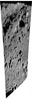
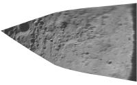
Latest news - Star Tracker images:
http://www.esa.int/SPECIALS/SMART-1/SEMPFY5LARE_0.html They are reproduced quite dark, but look what happens if you brighten them and do a little reprojection work
the lower one is located here (courtesy LPI):
I have not found the other one yet. Phil -------------------- ... because the Solar System ain't gonna map itself.
Also to be found posting similar content on https://mastodon.social/@PhilStooke Maps for download (free PD: https://upload.wikimedia.org/wikipedia/comm...Cartography.pdf NOTE: everything created by me which I post on UMSF is considered to be in the public domain (NOT CC, public domain) |
|||
|
|
|
|||
|
Aug 30 2006, 01:52 PM
Post
#43
|
|
 Senior Member Group: Members Posts: 3648 Joined: 1-October 05 From: Croatia Member No.: 523 |
What puzzles me is that the star tracker images appear to be interlaced (!?). It's as though they're using an ordinary alternate-field-readout video camera instead of progressively readout frames. I'd thought that would wreak havoc on the star recognition software.
What gives? -------------------- |
|
|
|
|
Aug 30 2006, 03:21 PM
Post
#44
|
|
|
Solar System Cartographer Group: Members Posts: 10193 Joined: 5-April 05 From: Canada Member No.: 227 |
There might be a difference between what the camera uses onboard for tracking and what it transmits.
Phil -------------------- ... because the Solar System ain't gonna map itself.
Also to be found posting similar content on https://mastodon.social/@PhilStooke Maps for download (free PD: https://upload.wikimedia.org/wikipedia/comm...Cartography.pdf NOTE: everything created by me which I post on UMSF is considered to be in the public domain (NOT CC, public domain) |
|
|
|
|
Aug 30 2006, 05:18 PM
Post
#45
|
|
|
Senior Member Group: Members Posts: 1636 Joined: 9-May 05 From: Lima, Peru Member No.: 385 |
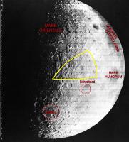
Will SMART-1 impact around the initially planned zone: Lacus Excellentiae localized about North East of Schickard crater? Now, with the recent post of Phil, the probably impact has moved up to North West of Schickard crater? That means that the previous planned impact zone won't be on the Lacus Excellentiae but other site.
Not yet know by sure where will SMART-1 be impacted doesn't it? Rodolfo |
|
|
|
|

|
Lo-Fi Version | Time is now: 16th June 2024 - 02:00 PM |
|
RULES AND GUIDELINES Please read the Forum Rules and Guidelines before posting. IMAGE COPYRIGHT |
OPINIONS AND MODERATION Opinions expressed on UnmannedSpaceflight.com are those of the individual posters and do not necessarily reflect the opinions of UnmannedSpaceflight.com or The Planetary Society. The all-volunteer UnmannedSpaceflight.com moderation team is wholly independent of The Planetary Society. The Planetary Society has no influence over decisions made by the UnmannedSpaceflight.com moderators. |
SUPPORT THE FORUM Unmannedspaceflight.com is funded by the Planetary Society. Please consider supporting our work and many other projects by donating to the Society or becoming a member. |
|