Victoria here we come..., Arrival minus one month and counting... |

  |
Victoria here we come..., Arrival minus one month and counting... |
 Sep 5 2006, 10:08 PM Sep 5 2006, 10:08 PM
Post
#586
|
||
 Senior Member  Group: Moderator Posts: 2262 Joined: 9-February 04 From: Melbourne - Oz Member No.: 16 |
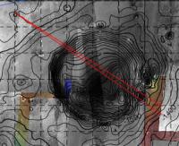
QUOTE (marswiggle @ Sep 6 2006, 03:01 AM)  Yes, babakm, I am thinking similarly about the horizon feature. I checked the very large colored Meridiani image comprising Victoria (taken by Mars Express possibly?) and the direction is about right if this is one of the mountains on the _big crater_ far rim. It can also be seen in the elevation map that was sent here, in the now closed 'Moving south to Vic' thread. The far (far) rim should be something like 40 km distant (?), I don't know actually. The link to the elevation map http://www.unmannedspaceflight.com/index.p...417&st=1455 QUOTE (babakm @ Sep 6 2006, 04:03 AM) Further to marswiggle's post, here's a crop of the slinted MEX image from this thread with a rough approximation of jamescanvin's vectors. There seem to be much better candidates on the far rim, although it seems incredibly far to be so clearly visible from here. Holy smoke! I think your right. Here are the heading vectors on that elevation map Tim posted:
A perfect match to one of the 'knots' of contours on the far rim. Wow! -------------------- |
|
 |
 
|
|
|
Sep 5 2006, 10:16 PM
Post
#587
|
|
 The Insider Group: Members Posts: 669 Joined: 3-May 04 Member No.: 73 |
QUOTE (dot.dk @ Sep 5 2006, 02:45 PM) Is that a fact or a guess?  Yes. 
|
|
|
|
|
Sep 5 2006, 10:19 PM
Post
#588
|
|
|
Solar System Cartographer Group: Members Posts: 10169 Joined: 5-April 05 From: Canada Member No.: 227 |
The direction looks good, but I have a problem with this idea. When Spirit saw the rim of Gusev, it was (as we would expect) very subdued in contrast compared with the foreground. Looking through a dusty atmosphere made the distant topography indistinct. But this hill has details on it every bit as contrasty as the surroundings. Anyway, only one small move should be enough for parallax to resolve the issue at once. Going out on a limb, I'll say I think it's close to the rim on the far side, like the mounds we are seeing up close here on the near rim.
Phil -------------------- ... because the Solar System ain't gonna map itself.
Also to be found posting similar content on https://mastodon.social/@PhilStooke Maps for download (free PD: https://upload.wikimedia.org/wikipedia/comm...Cartography.pdf NOTE: everything created by me which I post on UMSF is considered to be in the public domain (NOT CC, public domain) |
|
|
|
|
Sep 5 2006, 10:21 PM
Post
#589
|
|
 Member Group: Members Posts: 578 Joined: 5-November 04 From: Denmark Member No.: 107 |
QUOTE (Pando @ Sep 6 2006, 12:16 AM) Yes. That was very rude! 
-------------------- "I want to make as many people as possible feel like they are part of this adventure. We are going to give everybody a sense of what exploring the surface of another world is really like"
- Steven Squyres |
|
|
|
|
Sep 5 2006, 10:33 PM
Post
#590
|
|
|
Senior Member Group: Moderator Posts: 2262 Joined: 9-February 04 From: Melbourne - Oz Member No.: 16 |
QUOTE (Phil Stooke @ Sep 6 2006, 08:19 AM) The direction looks good, but I have a problem with this idea. When Spirit saw the rim of Gusev, it was (as we would expect) very subdued in contrast compared with the foreground. Looking through a dusty atmosphere made the distant topography indistinct. But this hill has details on it every bit as contrasty as the surroundings. Anyway, only one small move should be enough for parallax to resolve the issue at once. Going out on a limb, I'll say I think it's close to the rim on the far side, like the mounds we are seeing up close here on the near rim. Yeah I'm having a hard time beleving it really is *that* far away. I'm really looking forward to a bit of parallax. However I don't beleve it can be a mound close to the far rim as I'm pretty sure we're seeing a good expanse of annulus/plain beyond Victoria but in front of the feature. James Edit: Maybe it's time for a 'far rim' vs 'really far rim' pool.  
-------------------- |
|
|
|
|
Sep 5 2006, 10:44 PM
Post
#591
|
|
|
Member Group: Members Posts: 100 Joined: 20-May 06 Member No.: 780 |
QUOTE (jamescanvin @ Sep 5 2006, 06:08 PM) Here are the heading vectors on that elevation map Tim posted: I see some numbers on the contour lines in the elevation map: -1400, -1500. What unit of measurement applies to these numbers? |
|
|
|
|
Sep 5 2006, 10:48 PM
Post
#592
|
|
|
Senior Member Group: Members Posts: 2998 Joined: 30-October 04 Member No.: 105 |
QUOTE It's valuable to categorize the rocks at the current position since the impact that made the small crater has excavated some of the ejecta. I'll agree with Pando. This is a unique opportunity to examine and characterize Victoria's ejecta material. Once we get at Victoria there is going to be slumping, erosion and deposition that is secondary and occured long after the impact. Think of it as a "Qal" unit, which won't tell much about the Pliocene... Emma Dean is a fine roadcut. I'll also agree with Phil; the distant feature is too clear and contrasty to be of that distant crater, it has to be a far-rim Victoria feature. We'll know for sure after the next driving Sol. --Bill -------------------- |
|
|
|
|
Sep 5 2006, 11:06 PM
Post
#593
|
|
|
Senior Member Group: Moderator Posts: 2262 Joined: 9-February 04 From: Melbourne - Oz Member No.: 16 |
QUOTE (diane @ Sep 6 2006, 08:44 AM) I see some numbers on the contour lines in the elevation map: -1400, -1500. What unit of measurement applies to these numbers? Meters - (Oppys landing site (ellipse centre) was at -1440m) -------------------- |
|
|
|
|
Sep 5 2006, 11:10 PM
Post
#594
|
|
|
Senior Member Group: Members Posts: 1636 Joined: 9-May 05 From: Lima, Peru Member No.: 385 |
QUOTE (diane @ Sep 5 2006, 05:44 PM) I see some numbers on the contour lines in the elevation map: -1400, -1500. What unit of measurement applies to these numbers? Diane That is related to the Mars altitud reference that is 3,522.2 km of its equatorial radius: 3,397 km. Then the contour maps -1,400 meters (1.4 km) below of the reference, that is at 3,520.8 km from center of Mars. Rodolfo |
|
|
|
|
Sep 5 2006, 11:21 PM
Post
#595
|
|||
|
Junior Member Group: Members Posts: 48 Joined: 26-August 05 Member No.: 475 |
The large bump does appear to be on the far rim
If that white patch in the middle are dunes in the bottom, Victoria is not very deep.
|
||
|
|
|
||
|
Sep 5 2006, 11:43 PM
Post
#596
|
||
|
Senior Member Group: Moderator Posts: 2262 Joined: 9-February 04 From: Melbourne - Oz Member No.: 16 |
QUOTE (prometheus @ Sep 6 2006, 09:21 AM) If that white patch in the middle are dunes in the bottom, Victoria is not very deep.
Well I beleve that the white patch on the left side of that image (*just* over the near rim) is the far rim (or possibly Sofi crater) everything else is further away. We can't see inside Victoria yet, let alone the centre dunes! James -------------------- |
|
|
|
|
|
|
Sep 5 2006, 11:45 PM
Post
#597
|
|
|
Member Group: Members Posts: 100 Joined: 20-May 06 Member No.: 780 |
QUOTE (jamescanvin @ Sep 5 2006, 07:06 PM) Meters - (Oppys landing site (ellipse centre) was at -1440m) Thanks, James and Rodolfo. So if I'm reading the map right, within about 200 meters of the far rim, there's about a 100 meter drop in elevation? As compared to maybe a 20 or 30 meter drop from Oppy's current position to Vicky's near rim? That's why I was questioning the units. The terrain doesn't look that steep, but the numbers suggest that each contour line is a change in elevation of 25 meters. Unless I'm misreading it, somehow. |
|
|
|
|
Sep 5 2006, 11:49 PM
Post
#598
|
|
|
Member Group: Members Posts: 578 Joined: 5-November 04 From: Denmark Member No.: 107 |
SOL 931 is a driving sol and a check of the RAT bits
CODE 931 p0685.03 0 0 0 0 0 0 navcam_5x1_az_144_3_bpp 931 p1149.01 0 0 0 0 0 0 frhaz_RAT_bit_check_subframe_loco_pri_56 931 p1149.01 0 0 0 0 0 0 frhaz_RAT_bit_check_subframe_loco_pri_56 931 p1149.01 0 0 0 0 0 0 frhaz_RAT_bit_check_subframe_loco_pri_56 931 p1151.04 0 0 0 0 0 0 front_hazcam_idd_unstow_doc 931 p1154.01 0 0 0 0 0 0 front_hazcam_idd_unstow_doc 931 p1205.08 0 0 0 0 0 0 front_haz_penultimate_0.5_bpp_pri17 931 p1214.05 0 0 0 0 0 0 front_haz_ultimate_4bpp_pri15 931 p1305.07 0 0 0 0 0 0 rear_haz_penultimate_0.5bpp_pri17 931 p1311.07 0 0 0 0 0 0 rear_haz_ultimate_1_bpp_crit15 931 p1976.05 0 0 0 0 0 0 navcam_5x1_az_324_1bpp_pri_23 931 p2631.01 0 0 0 0 0 0 pancam_sky_spot_L234567R34567 Total 0 0 0 0 0 0 But no drive direction panorama? Are they gonna do some work here or do they not predict to be able to do more forward driving once they are at the rim of Victoria?
-------------------- "I want to make as many people as possible feel like they are part of this adventure. We are going to give everybody a sense of what exploring the surface of another world is really like"
- Steven Squyres |
|
|
|
|
Sep 5 2006, 11:53 PM
Post
#599
|
|
|
Senior Member Group: Moderator Posts: 2262 Joined: 9-February 04 From: Melbourne - Oz Member No.: 16 |
QUOTE (diane @ Sep 6 2006, 09:45 AM) Thanks, James and Rodolfo. So if I'm reading the map right, within about 200 meters of the far rim, there's about a 100 meter drop in elevation? As compared to maybe a 20 or 30 meter drop from Oppy's current position to Vicky's near rim? That's why I was questioning the units. The terrain doesn't look that steep, but the numbers suggest that each contour line is a change in elevation of 25 meters. Unless I'm misreading it, somehow. I think you might be confused about the scale of that map - Victoria is that little circle next to the apex of my sight lines, the big crater is the *huge* one to the south east thats 10's of km across. James -------------------- |
|
|
|
|
Sep 6 2006, 12:00 AM
Post
#600
|
|
|
Member Group: Members Posts: 100 Joined: 20-May 06 Member No.: 780 |
QUOTE (jamescanvin @ Sep 5 2006, 07:53 PM) I think you might be confused about the scale of that map - Victoria is that little circle next to the apex of my sight lines, the big crater is the *huge* one to the south east thats 10's of km across. Indeed! Thanks, James. All this excitement over a big hole in the ground, and it turns out that it's not even so big... Well, we're just going to have to take up a collection so we can send Oppy a maid service to dust off her panels, so she can make it to the next crater! |
|
|
|
|

|
Lo-Fi Version | Time is now: 27th May 2024 - 06:05 PM |
|
RULES AND GUIDELINES Please read the Forum Rules and Guidelines before posting. IMAGE COPYRIGHT |
OPINIONS AND MODERATION Opinions expressed on UnmannedSpaceflight.com are those of the individual posters and do not necessarily reflect the opinions of UnmannedSpaceflight.com or The Planetary Society. The all-volunteer UnmannedSpaceflight.com moderation team is wholly independent of The Planetary Society. The Planetary Society has no influence over decisions made by the UnmannedSpaceflight.com moderators. |
SUPPORT THE FORUM Unmannedspaceflight.com is funded by the Planetary Society. Please consider supporting our work and many other projects by donating to the Society or becoming a member. |
|