November 29 MRO Image Release, 13 New Images |

  |
November 29 MRO Image Release, 13 New Images |
 Nov 30 2006, 12:22 AM Nov 30 2006, 12:22 AM
Post
#31
|
||
|
Founder  Group: Chairman Posts: 14432 Joined: 8-February 04 Member No.: 1 |
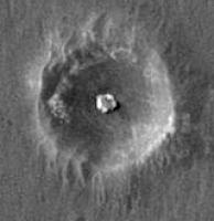
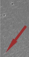
Stretch the hell out of it and you can eve see some of the tracking within eagle including the failed egress attemtpt at about 2 O'clock. Also - tracks visible toward and away from Fram - and around the Endurance rim...and the major slippage events near the rocks on the southern side inside Endurance are quite visible.
That there is anything visible at all after some 2+yeras is amazing. Doug
Attached thumbnail(s)
|
|
 |
 
|
|
| Guest_Sunspot_* |
Nov 30 2006, 12:38 AM
Post
#32
|
|
|
Guests |
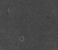
I have a request to anyone that has the full size Merdiani image. In the original MOC image there is a very dark spot that looked like the Heatshield impact site only it was located further south. It forms a triangle with the feature named Vostok and another smaller crater. There was some speculation it could have been a recent impact site. Is it visible in the HiRISE image?
Attached a crop of the MOC image.
Attached thumbnail(s)
|
|
|
|
|
|
|
Nov 30 2006, 12:39 AM
Post
#33
|
|
 Administrator Group: Admin Posts: 5172 Joined: 4-August 05 From: Pasadena, CA, USA, Earth Member No.: 454 |
OK, I've clipped out chunks of the Opportunity route into JPEGs that are all under 2 MB in size and hosted them for you. You can send your thanks in the form of donations to the Society
 Backshell to Endurance (0.87 MB) Endurance to Vostok (1.97 MB) Vostok to Erebus Highway (1.64 MB) Erebus to middle of Etched Terrain (1.83 MB) Etched Terrain to Beagle (1.26 MB) Beagle to Victoria (1.2 MB) Enjoy! --Emily -------------------- My website - My Patreon - @elakdawalla on Twitter - Please support unmannedspaceflight.com by donating here.
|
|
|
|
|
Nov 30 2006, 12:43 AM
Post
#34
|
|
 Senior Member Group: Admin Posts: 4763 Joined: 15-March 05 From: Glendale, AZ Member No.: 197 |
Wow (again) clink clink.
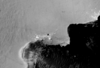
You can see still see the rover tracks below the south rim of Endurance. -------------------- If Occam had heard my theory, things would be very different now.
|
|
|
|
|
Nov 30 2006, 12:55 AM
Post
#35
|
||
|
Administrator Group: Admin Posts: 5172 Joined: 4-August 05 From: Pasadena, CA, USA, Earth Member No.: 454 |
...and a flicker gif of Opportunity...
--Emily -------------------- My website - My Patreon - @elakdawalla on Twitter - Please support unmannedspaceflight.com by donating here.
|
|
|
|
|
|
| Guest_Sunspot_* |
Nov 30 2006, 01:22 AM
Post
#36
|
|
Guests |
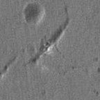
Anatolia Fault, Sol 72, NavCam
http://marsrovers.jpl.nasa.gov/gallery/all...0P1803L0M1.HTML http://marsrovers.jpl.nasa.gov/gallery/all...0P1803R0M1.HTML Did we ever find out what these were?
Attached image(s)
|
|
|
|
|
Nov 30 2006, 02:22 AM
Post
#37
|
|
 Senior Member Group: Members Posts: 1281 Joined: 18-December 04 From: San Diego, CA Member No.: 124 |
QUOTE (elakdawalla @ Nov 29 2006, 04:39 PM)  Backshell to Endurance (0.87 MB) Uh, I think I can see Wopmay from space in that.... mmbrgule...drool.... 
-------------------- Lyford Rome
"Zis is not nuts, zis is super-nuts!" Mathematician Richard Courant on viewing an Orion test |
|
|
|
|
Nov 30 2006, 03:41 AM
Post
#38
|
|
 Senior Member Group: Members Posts: 3419 Joined: 9-February 04 From: Minneapolis, MN, USA Member No.: 15 |
QUOTE (Sunspot @ Nov 29 2006, 08:22 PM) Anatolia Fault, Sol 72, NavCam ... Did we ever find out what these were? The only full-fledged geological analysis of the plains around Endurance that I've seen referenced anywhere seems to call them "materials removal features," or somesuch. From what I've been able to tell, they identified them as cracks that formed in the upper surface due to removal of volatiles (i.e., ice and water) from the substrate as part of the long-term evaporation process. That does pose the problem of the lack of aeolian fill -- if these cracks were formed three billion years ago when all the water is supposed to have evaporated out of this place, why haven't they been filled with dust by now? -the other Doug -------------------- The trouble ain't that there is too many fools, but that the lightning ain't distributed right. -Mark Twain
|
|
|
|
|
Nov 30 2006, 05:17 AM
Post
#39
|
|
|
Senior Member Group: Members Posts: 2998 Joined: 30-October 04 Member No.: 105 |
Thanks, Emily. These MRO images, along with Phil's excellent route map and Oppy's ground truth will make it possible to begin to understand what's happening in this Wonderland...
--Bill -------------------- |
|
|
|
|
Nov 30 2006, 05:18 AM
Post
#40
|
|||
|
Senior Member Group: Admin Posts: 4763 Joined: 15-March 05 From: Glendale, AZ Member No.: 197 |
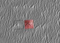
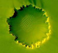
OK I found Purgatory. Starting with Phil's map (Thanks Emily for digging that up and hosting it ..the check is in the mail)...and then overlaying the vertical projection from sol 446 (inserted in red below). The geometry is slightly off in the vertical projection, but I guess that's to be expected.
Sure enough though there's still a bright streak there.
Attached thumbnail(s)
-------------------- If Occam had heard my theory, things would be very different now.
|
||
|
|
|
||
|
Nov 30 2006, 05:30 AM
Post
#41
|
|
|
Member Group: Members Posts: 428 Joined: 21-August 06 From: Northern Virginia Member No.: 1062 |
QUOTE (ElkGroveDan @ Nov 29 2006, 10:18 PM) OK I found Purgatory. Starting with Phil's map (Thanks Emily for digging that up and hosting it ..the check is in the mail)...and then overlaying the vertical projection from sol 446 (inserted in red below). The geometry is slightly off in the vertical projection, but I guess that's to be expected. Sure enough though there's still a bright streak there. I still remember Jason and I finding Purgatory one day shortly after the first picture was taken. Problem is, I know we used the ISIS file, and I'm not sure if the whole image was released or not at the time... Still, it was fun. |
|
|
|
|
Nov 30 2006, 07:09 AM
Post
#42
|
|
 Senior Member Group: Members Posts: 2492 Joined: 15-January 05 From: center Italy Member No.: 150 |
Thanks, Emily. Your croppings are really useful and animation is amazing!
I love this toy... -------------------- I always think before posting! - Marco -
|
|
|
|
|
Nov 30 2006, 08:28 AM
Post
#43
|
|
 Member Group: Members Posts: 370 Joined: 12-September 05 From: France Member No.: 495 |
Thanks Emily for all your posts.
I am really impressed by the gullies. I've just a little question. If these gullies are created by avalanches of fluidized sand, why don't we see some build up of sand at the end ?  -- Rakhir |
|
|
|
|
Nov 30 2006, 10:44 AM
Post
#44
|
||
|
Founder Group: Chairman Posts: 14432 Joined: 8-February 04 Member No.: 1 |
I can't tell if I got them the right way around, I can't identify one spec to co-register for a great image - I'm not sure I've done it right at all...
but it looks cool.
Attached thumbnail(s)
|
|
|
|
|
|
|
Nov 30 2006, 11:12 AM
Post
#45
|
|
 Special Cookie Group: Members Posts: 2168 Joined: 6-April 05 From: Sintra | Portugal Member No.: 228 |
QUOTE (elakdawalla @ Nov 30 2006, 12:05 AM) Here's the Oppy landing site from the backshell through Endurance: --Emily Wow!... Thanks for everything Emily... Really impressive detail... I'm sure someone can do better than me on this... Eagle Crater Backshell + Parachute Wow!... +2 Oppy Heat Shield -------------------- "Ride, boldly ride," The shade replied, "If you seek for Eldorado!"
Edgar Alan Poe |
|
|
|
|

|
Lo-Fi Version | Time is now: 30th May 2024 - 03:25 AM |
|
RULES AND GUIDELINES Please read the Forum Rules and Guidelines before posting. IMAGE COPYRIGHT |
OPINIONS AND MODERATION Opinions expressed on UnmannedSpaceflight.com are those of the individual posters and do not necessarily reflect the opinions of UnmannedSpaceflight.com or The Planetary Society. The all-volunteer UnmannedSpaceflight.com moderation team is wholly independent of The Planetary Society. The Planetary Society has no influence over decisions made by the UnmannedSpaceflight.com moderators. |
SUPPORT THE FORUM Unmannedspaceflight.com is funded by the Planetary Society. Please consider supporting our work and many other projects by donating to the Society or becoming a member. |
|