Titan's Equatorial Sand Seas |

  |
Titan's Equatorial Sand Seas |
 Jun 5 2007, 10:32 AM Jun 5 2007, 10:32 AM
Post
#61
|
|
|
Senior Member  Group: Members Posts: 3516 Joined: 4-November 05 From: North Wales Member No.: 542 |
QUOTE (Juramike @ Jun 4 2007, 05:31 PM)  From the logic above, the best places to look for tidal channels would be nearest the sub-Saturn and anti-Saturn points Are you sure about this? I would expect these to be points of maximal rise and fall, but minimal horizontal flow (and that due to libration only). The great circle where Saturn is on the horizon would also be a place of high rise and fall but little horizontal displacement. I would expect the zones of maximal horizontal flow to form small circles midway between in both hemispheres, say 30 - 60 degrees from the sub and anti Saturn points. |
 |
 
|
|
Jun 5 2007, 11:12 AM
Post
#62
|
|
|
Senior Member Group: Members Posts: 3516 Joined: 4-November 05 From: North Wales Member No.: 542 |
QUOTE (Juramike @ Jun 4 2007, 05:31 PM) Is the Huygens channel a former tidal channel? I've given some thought to that. For the moment I accept that the local topography could have been modified by tidal action at some time(s) in the distant past. However I don't think it can be responsible for the (more recent/more frequent?) emplacement of the giant gravel banks. Those are, I think, just too big, and they look much more like the products of individual catastrophic events than the result of regular tidal washing. |
|
|
|
|
Jun 5 2007, 04:34 PM
Post
#63
|
||
 Senior Member Group: Moderator Posts: 2785 Joined: 10-November 06 From: Pasadena, CA Member No.: 1345 |
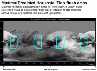
QUOTE (ngunn @ Jun 5 2007, 06:32 AM) Are you sure about this? I would expect these to be points of maximal rise and fall, but minimal horizontal flow (and that due to libration only). The great circle where Saturn is on the horizon would also be a place of high rise and fall but little horizontal displacement. I would expect the zones of maximal horizontal flow to form small circles midway between in both hemispheres, say 30 - 60 degrees from the sub and anti Saturn points. Your are totally correct. Further digging into the articles states that maximal horizontal displacement will be in an area near 45 degrees of the SubSaturn and AntiSaturn points. (Due to libration they would have a time-averaged slight oval shape, however.) But also remember that we are looking at constricted channels. So a large vertical displacement (inside 45 degree zone) on one side of the channel will translate to a height differential across the channel if the flow is sufficiently restricted on one side. (e.g. an open bay on one side, but a narrow channel on the other). Here is a corrected map of maximal horizontal tidal flush (overlaid in the Equatorial Dune seas area)
(Happily, the W Belet Channel at 290 W is only slightly outside this zone (on the "bad" side, however)) But remember, only a differential of 1.5 M carved out Deception Pass. -Mike -------------------- Some higher resolution images available at my photostream: http://www.flickr.com/photos/31678681@N07/
|
|
|
|
|
|
|
Jun 5 2007, 05:52 PM
Post
#64
|
|
|
Senior Member Group: Moderator Posts: 2785 Joined: 10-November 06 From: Pasadena, CA Member No.: 1345 |
QUOTE (ngunn @ Jun 5 2007, 07:12 AM) I've given some thought to that. For the moment I accept that the local topography could have been modified by tidal action at some time(s) in the distant past. However I don't think it can be responsible for the (more recent/more frequent?) emplacement of the giant gravel banks. Those are, I think, just too big, and they look much more like the products of individual catastrophic events than the result of regular tidal washing. Those gravel banks are really, really big. (Almost as big as the summit of the island at the Huygens landing site.) I'm invoking their initial placement during an even earlier and even bigger inundation (at least to the 120 m level in the terrain model.) I was speculating that the gravel banks were dumped during a massively huge ancient indundation (an inundation before the last indundation, or inundation N-1). That put the material there initially, then tidal action, (again during the N-1 inundation) reworked the gravels and scoured out the potholes. I'll further speculate that the last (most recent) inundation's tidal action would not have been sufficient to gouge out the huge initial potholes, they must have been pre-existing. But it may have been enough to carve lower lying channels and fill in/carve out some of the lower parts of accessible potholes. (30 m level in the topography models = bright-dark boundary = putative max most recent inundation level ) Anything accessible to liquid during the last inundation would have been fair game for carving during a tidal flush. Anything above 30 m in the terrain model, or anything surrounded by a 30 m high wall should have been cut off and insulated from carving during the most recent big inundation. I wonder if it is possible to tell from morphology the difference between bottom features carved during a catastrophic event or from back-and-forth tidal flushes. (Tilt table with sand and a garden hose on a hot summer evening?) -Mike -------------------- Some higher resolution images available at my photostream: http://www.flickr.com/photos/31678681@N07/
|
|
|
|
|
Jun 5 2007, 06:07 PM
Post
#65
|
|
|
Senior Member Group: Members Posts: 3516 Joined: 4-November 05 From: North Wales Member No.: 542 |
Well, one striking characteristic of the 'hooded dude' gravel banks is their unidirectional appearance. Another is evidence from the Huygens surface view that the pebbles look remarkably fresh and clean, not at all as if they'd been lying about under a dirty atmosphere for geological time spans. That's why I go for a recent weather/cryovolcanic-induced deluge (which could also have erased any dunes at this location?). Of course the whole channel that this flood poured through could have been formed much earlier, possibly in part by tides.
|
|
|
|
|
Jun 5 2007, 07:46 PM
Post
#66
|
|
|
Senior Member Group: Moderator Posts: 2785 Joined: 10-November 06 From: Pasadena, CA Member No.: 1345 |
That's a really good point on the clean-looking cobbles. Maybe the last rain event cleaned them off?
(I'm not totally convinced that tholins are plooping out of the atmosphere all over the place - at least we know that the tholin deposition rate rate less than 1 mm/ h at the Huygens site) The flow in the Soderblom article has the Huygens channel major flow going from SW to NE. But the "hooded dude" formation seems tapered as if the flow was going from NE to SW. At least the pointy part is on the NE side. (Then you also have the small channels cross-cutting the bars going from W to E - that's probably from "normal" flooding rain events.) I'd love to find a marine chart with bottom features resembling the "hooded dude" formation. At least it might give us a clue which way the current could go to make analogous formations. -Mike -------------------- Some higher resolution images available at my photostream: http://www.flickr.com/photos/31678681@N07/
|
|
|
|
|
Jun 5 2007, 08:12 PM
Post
#67
|
|
|
Senior Member Group: Members Posts: 3516 Joined: 4-November 05 From: North Wales Member No.: 542 |
QUOTE (Juramike @ Jun 5 2007, 06:52 PM) bottom features carved during a catastrophic event-Mike I'm not sure they have to be 'bottom' features. The pebbles could be bouyant flotsam. In that way the terminal gravel bank at the end of a flood wash could actually be higher than the depth of liquid transporting it. Maybe images of rubbish washed inland by tsunamis would be somewhere to look for analogues. |
|
|
|
|
Jun 5 2007, 09:10 PM
Post
#68
|
|
|
Senior Member Group: Moderator Posts: 2785 Joined: 10-November 06 From: Pasadena, CA Member No.: 1345 |
QUOTE (ngunn @ Jun 5 2007, 04:12 PM) The pebbles could be bouyant flotsam. In that way the terminal gravel bank at the end of a flood wash could actually be higher than the depth of liquid transporting it. Hmm. That's interesting. I have been assuming that the pebbles were made of primarily ice. The density of methane should be around 0.6 g/mL and that of ice-sand (or pebbles) should be around 1 g/mL. BUT there is the chance that the ice cobbles are nanoporous ice (density = ?) or that maybe the cobbles were coated in low density stuff that dissolved away? But to bring the average less than the hydrocarbon liquid (d = 0.6 g/mL) it would have to be really low density stuff. In a really turbulent white-methane flow, air (nitrogen) would get incorporated in the frothy mess, that would drive the density of the liquid lower and make it even less supportive of denser materials. One possibilitie to make the gravel stuff behave like it floated would be glacial (methane/ethane glacier?) - ice rocks get transported along top of the glacial flow, then dumped moraine-like at the terminus and along the base after melting/sublimation. This would result in an unsorted deposit. (But maybe the deposits we see in the surface images have been later reworked - Huygens did not land on the very top of the big gravel bank). Another possibility would be a lahar or landslide on an air cushion, (followed by reworking at the Huygens site). But you'd need a really big mountain somewhere close. (I'm partial to the glacial idea, the m.p of methane is about 90 K at Earth pressure) -Mike -------------------- Some higher resolution images available at my photostream: http://www.flickr.com/photos/31678681@N07/
|
|
|
|
|
Jun 5 2007, 10:07 PM
Post
#69
|
|
|
Senior Member Group: Moderator Posts: 2785 Joined: 10-November 06 From: Pasadena, CA Member No.: 1345 |
Following the calculations in the Sagan, Dermott, and Lorenz papers, I repeated their calculations for the putative W Belet channel to see if tidal resonance could furnish exteme tides (like in Bay of Fundy)
From the Sagan, Dermot and Lorenz papers, the formula for a tidal resonance is: Tg = 2L/[N(gD)^0.5] where N is the mode number (well use 1), g is the surface gravity (g = 1.34 ms-2), D is the depth of the basin, and L is the length of the basin along the direction of wave propogation. Resonance arises when one of the periods of the normal modes equals the tidal period, or in the case of Titan, the orbital period of the satellite, T (T = 5.4E6 s). For the channel in W Belet/E Senkyo, the basin to the NW (from the ISS image) has a EW length of 500 km. (Happily, the E Senkyo side to the SW is about the same size.) Assuming a depth of 1-200 m from the above posts estimation we then get: (gD)^0.5 = 1.2 16.3 ms-1 [similar values as the articles above indicated] Applying this to the W Belet basin: Resonant period is 1E6 m/1.2 ms-1 = 8.3E5 s. Which is still shorter than the orbital period of 5.4E6 s. (Bummer). However, if we consider a larger basin with a large EW fetch, such as Shangri-La (2000 km EW basin size), we get a resonant period of: 4E6 m/1.2 ms-1 = 3.3E6. Which is approx half of the orbital period (so its close, but no cigar (Bummer)). For there to be tidal resonance, the seas would need to be much larger, but still shallow. However, just like on Earth, local tide effects on Titan could be strongly controlled by bottom topography, currents and complicated gyres in the sea basins. These would need to be invoked for above average tidal currents, since resonance effects do not seem a likely player. (Happily, I have absolutely no idea how to predict or calculate these). -Mike P.S. Assuming a bottom slope of 0.1% due to downwarp, the maximum tide range of a 9 m tide bulge differential would give an intertidal distance of 10 km. So really impressive beaches are possible in large tidal basins where the tidal height range is largest, near the Anti-Saturn or Sub-Saturn points (W Shangri-La basin or E Aztlan) Then E Fensal (where we have altimetry data) area should have been a large intertidal zone and will be interesting to examine by ISS and upcoming RADAR passes. (Sadly, the Fens of E Fensal are probably covered by dune sands now no more Titan oyster beds!) -------------------- Some higher resolution images available at my photostream: http://www.flickr.com/photos/31678681@N07/
|
|
|
|
|
Jun 5 2007, 10:18 PM
Post
#70
|
||
|
Senior Member Group: Moderator Posts: 2785 Joined: 10-November 06 From: Pasadena, CA Member No.: 1345 |
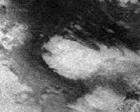
Does anyone have an idea what the heck these are? (clipped from ISS, RADAR and ISS/RADAR combos)
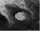 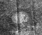 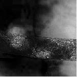
They have RADAR/ISS bright centers (rough, high domes?) with a RADAR-dark ISS dark halo (low, smooth moat?). They sometimes appear squished in the direction of putative tectonic extension. (I'm calling them "center-bright circular features"). I'm seeing them everywhere in the Equatorial Sand Sea basins... Speculation, anyone? -Mike -------------------- Some higher resolution images available at my photostream: http://www.flickr.com/photos/31678681@N07/
|
|
|
|
|
|
|
Jun 6 2007, 10:07 AM
Post
#71
|
|
|
Senior Member Group: Members Posts: 3516 Joined: 4-November 05 From: North Wales Member No.: 542 |
QUOTE (Juramike @ Jun 5 2007, 10:10 PM) Hmm. That's interesting. I have been assuming that the pebbles were made of primarily ice. The density of methane should be around 0.6 g/mL and that of ice-sand (or pebbles) should be around 1 g/mL. BUT there is the chance that the ice cobbles are nanoporous ice (density = ?) or that maybe the cobbles were coated in low density stuff that dissolved away? But to bring the average less than the hydrocarbon liquid (d = 0.6 g/mL) it would have to be really low density stuff. -Mike On possible low density pebbles: Recall that terrestrial silicate rocks are about 2.5 times denser than water, yet pumice pebbles can float right across terrestrial oceans. I'm not saying all the surface ices on Titan are similarly aerated and impermeable in this way, only that a fraction of them may be. But it is precisely that fraction that would be carried furthest in a flood and which you'd expect to find uppermost in the resulting debris pile. Gases escape more easily from liquids than from solids so it would not surprise me if the mean liquid density of even a frothy Titan outwash flood were still greater than at least some of the solid material being transported. |
|
|
|
|
Jun 6 2007, 12:02 PM
Post
#72
|
|
|
Senior Member Group: Members Posts: 3516 Joined: 4-November 05 From: North Wales Member No.: 542 |
A further thought - two plausible eruption products from Titan cryovolcanism are large volumes of condensable methane and aerated 'pyroclastic' (or should we say cryoclastic) bombs and ice-ash. Thus one could envisage such an event providing both the gravel-bank material seen by Huygens and, via a rain-bearing eruption cloud, the exceptional supply of liquid needed to transport it to Curien Station.
|
|
|
|
|
Jun 6 2007, 02:47 PM
Post
#73
|
|
|
Senior Member Group: Members Posts: 3516 Joined: 4-November 05 From: North Wales Member No.: 542 |
QUOTE (Juramike @ Jun 5 2007, 11:18 PM) Does anyone have an idea what the heck these are? (I'm calling them "center-bright circular features"). I'm seeing them everywhere in the Equatorial Sand Sea basins... Speculation, anyone? -Mike Diapirs? |
|
|
|
|
Jun 6 2007, 05:36 PM
Post
#74
|
|
|
Senior Member Group: Moderator Posts: 2785 Joined: 10-November 06 From: Pasadena, CA Member No.: 1345 |
Cryopumice is a very interesting concept. Those types of ice rocks would also be more prone to erosion and rounding. (As the walls between vesicles should break easier).
I wonder what a cryopumice field would look like by RADAR? Would the Titan equivalent of a cinder cone look like a bright zone? How high would it get thrown? What would it look like from above? Would the pumice field be a cone shaped feature pointing downwind, or would the eruption be low enough that the flat parabola trajectory would make a circle shaped feature? -Mike -------------------- Some higher resolution images available at my photostream: http://www.flickr.com/photos/31678681@N07/
|
|
|
|
|
Jun 6 2007, 06:35 PM
Post
#75
|
|
 Senior Member Group: Moderator Posts: 3233 Joined: 11-February 04 From: Tucson, AZ Member No.: 23 |
QUOTE (Juramike @ Jun 6 2007, 10:36 AM) Would the pumice field be a cone shaped feature pointing downwind You mean, like Omacatl Macula  ISS sees a parabola-shaped dark deposit. RADAR sees a small, smooth deposit centered around a 6-km wide caldera-like feature. I've always attributed the smooth deposit to indicate a low-dielectric constant material with small particle sizes compared to the wavelength of the radar. Basically an ashfall deposit with relatively few large pumice. ISS sees a parabola-shaped dark deposit. RADAR sees a small, smooth deposit centered around a 6-km wide caldera-like feature. I've always attributed the smooth deposit to indicate a low-dielectric constant material with small particle sizes compared to the wavelength of the radar. Basically an ashfall deposit with relatively few large pumice.
-------------------- &@^^!% Jim! I'm a geologist, not a physicist!
The Gish Bar Times - A Blog all about Jupiter's Moon Io |
|
|
|
|

|
Lo-Fi Version | Time is now: 5th June 2024 - 10:05 PM |
|
RULES AND GUIDELINES Please read the Forum Rules and Guidelines before posting. IMAGE COPYRIGHT |
OPINIONS AND MODERATION Opinions expressed on UnmannedSpaceflight.com are those of the individual posters and do not necessarily reflect the opinions of UnmannedSpaceflight.com or The Planetary Society. The all-volunteer UnmannedSpaceflight.com moderation team is wholly independent of The Planetary Society. The Planetary Society has no influence over decisions made by the UnmannedSpaceflight.com moderators. |
SUPPORT THE FORUM Unmannedspaceflight.com is funded by the Planetary Society. Please consider supporting our work and many other projects by donating to the Society or becoming a member. |
|