Titan's Equatorial Sand Seas |

  |
Titan's Equatorial Sand Seas |
 Jun 6 2007, 09:16 PM Jun 6 2007, 09:16 PM
Post
#76
|
|
 Senior Member  Group: Moderator Posts: 2785 Joined: 10-November 06 From: Pasadena, CA Member No.: 1345 |
QUOTE (volcanopele @ Jun 6 2007, 02:35 PM)  You mean, like Omacatl Macula  ISS sees a parabola-shaped dark deposit. RADAR sees a small, smooth deposit centered around a 6-km wide caldera-like feature. I've always attributed the smooth deposit to indicate a low-dielectric constant material with small particle sizes compared to the wavelength of the radar. Basically an ashfall deposit with relatively few large pumice. ISS sees a parabola-shaped dark deposit. RADAR sees a small, smooth deposit centered around a 6-km wide caldera-like feature. I've always attributed the smooth deposit to indicate a low-dielectric constant material with small particle sizes compared to the wavelength of the radar. Basically an ashfall deposit with relatively few large pumice.(Image of Omacatl Macula here) I guess that would be one flavor of an ashfall eruption. I was wondering if there might be another flavor of eruption with larger chunks of pumice that wouldn't fly as far or distrubute downwind. I would think something like that might appear bright to RADAR, but may or may not appear bright to ISS/VIMS. (I'm speculating that ISS brightness is dependant on altitude above or below the last inundation high-sea mark.) -Mike -------------------- Some higher resolution images available at my photostream: http://www.flickr.com/photos/31678681@N07/
|
 |
 
|
|
Jun 6 2007, 09:47 PM
Post
#77
|
|
 Senior Member Group: Moderator Posts: 3233 Joined: 11-February 04 From: Tucson, AZ Member No.: 23 |
I think such a feature might have been seen in northern Fensal, surrounding a possible Ganesa-like pancake dome with a flow to the north.
-------------------- &@^^!% Jim! I'm a geologist, not a physicist!
The Gish Bar Times - A Blog all about Jupiter's Moon Io |
|
|
|
|
Jun 6 2007, 09:49 PM
Post
#78
|
|
|
Senior Member Group: Moderator Posts: 2785 Joined: 10-November 06 From: Pasadena, CA Member No.: 1345 |
Cool-o! Was that by RADAR or VIMS?
Got coordinates?  -Mike -------------------- Some higher resolution images available at my photostream: http://www.flickr.com/photos/31678681@N07/
|
|
|
|
|
Jun 6 2007, 10:20 PM
Post
#79
|
|
|
Senior Member Group: Moderator Posts: 3233 Joined: 11-February 04 From: Tucson, AZ Member No.: 23 |
You know, ISS does take images of Titan too...
  The feature, which I really should get a name submitted for, is located at 12.3 N, 43.8 West. RADAR saw rough, IR-dark terrain just to the south of the feature on T17. -------------------- &@^^!% Jim! I'm a geologist, not a physicist!
The Gish Bar Times - A Blog all about Jupiter's Moon Io |
|
|
|
|
Jun 6 2007, 10:46 PM
Post
#80
|
|
|
Senior Member Group: Moderator Posts: 2785 Joined: 10-November 06 From: Pasadena, CA Member No.: 1345 |
QUOTE (volcanopele @ Jun 6 2007, 06:20 PM) 12.3 N, 43.8 West. Got it. Bingo! Actually, I was thinking that the parent feature (just to the N and out of view of the T17 RADAR swath) may actually be a tiny version of a multi-ring crater (mini-Minrva, rim diameter = ca 120 km). There appears to be a dark halo surrounding this feature as well (approx halo diameter 475 km x 300 km, squished in the direction 20 degrees to N). (I suspect that three [two for sure, maybe a third] of the Minrva-type multi-ring craters are wedged in the space between the T17 and T3 swath. All three were just barely missed by the two paths (Bummer!), although some of the associated bright patch for the 12.3 N, 43.8 W are visible in T17 swath. ) So maybe another possibility for the bright center dark halo circle features are cryopumice fields, along with diapirs and their kin, or anamolous dome craters like seen on Callisto. Any ideas for why there is a dark halo/depression surrounding some of these features? -Mike -------------------- Some higher resolution images available at my photostream: http://www.flickr.com/photos/31678681@N07/
|
|
|
|
|
Jun 6 2007, 10:57 PM
Post
#81
|
||
|
Senior Member Group: Moderator Posts: 2785 Joined: 10-November 06 From: Pasadena, CA Member No.: 1345 |
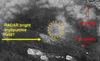
Here is an image of the feature (multi-ring Minrva style crater?) at 12.3 N, 43.8 W. :
Yellow arrow indicates the putative pumice field discussed in the above posts. Outline of "outer bright rim" of crater in dashed orange. (I also indicated the location of the T3 and T17 swaths in the image just to show how close they were to snagging this feature. Double-bummer!) Image modified from Exploitcorporations Fensal-Aztlan mosaic. -Mike -------------------- Some higher resolution images available at my photostream: http://www.flickr.com/photos/31678681@N07/
|
|
|
|
|
|
|
Jun 6 2007, 11:21 PM
Post
#82
|
|
|
Senior Member Group: Moderator Posts: 3233 Joined: 11-February 04 From: Tucson, AZ Member No.: 23 |
Yeah, I just don't see how that is similar to Menrva (or Sinlap, which it is close in size to). To me, it would appear that the feature outlined in the yellow ring of dots is a Ganesa-like pancake dome. It doesn't appear to be a depression, like Sinlap, given that dark material has not covered what would be the crater floor, but some intermediate albedo material has been deposited on it. That material is not nearly as dark as the material that has partially filled in Sinlap and Menrva. Several flow like features can be seen spreading out from the eastern margin, the most prominent of these makes a left turn and flows to the north of the volcanic dome.
-------------------- &@^^!% Jim! I'm a geologist, not a physicist!
The Gish Bar Times - A Blog all about Jupiter's Moon Io |
|
|
|
|
Jun 6 2007, 11:59 PM
Post
#83
|
|
|
Senior Member Group: Moderator Posts: 2785 Joined: 10-November 06 From: Pasadena, CA Member No.: 1345 |
I was taking the analogy of it looking like it had a multi-ring appearance (like Minrva). It looks kinda like a squished blurry sand dollar.
Maybe a better term would be "multi-ring circular feature". That leaves open the possibility that it is impact, cryovolcanic, or impact/cryovolcanic, (and diapir). There is another similar looking thing at 5 N, 343 W (in Aaru). Actually, I think there are a couple of these multi-ring things in the Fensal-Aaru area. I'm working on a huge post of speculative "circle features". -Mike -------------------- Some higher resolution images available at my photostream: http://www.flickr.com/photos/31678681@N07/
|
|
|
|
|
Jun 7 2007, 12:11 AM
Post
#84
|
|
|
Senior Member Group: Moderator Posts: 3233 Joined: 11-February 04 From: Tucson, AZ Member No.: 23 |
Now that feature in Aaru reminds me of Menrva, with a central bright spot, surrounded by a ring of dark material, surrounded by a ring of bright material. I just don't see a multi-ring structure at that feature at that feature northern Fensal.
-------------------- &@^^!% Jim! I'm a geologist, not a physicist!
The Gish Bar Times - A Blog all about Jupiter's Moon Io |
|
|
|
|
Jun 7 2007, 12:36 AM
Post
#85
|
|||||||||
|
Senior Member Group: Moderator Posts: 2785 Joined: 10-November 06 From: Pasadena, CA Member No.: 1345 |
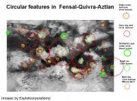
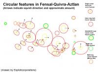
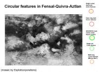
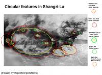
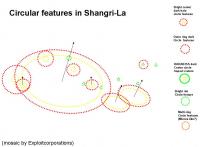
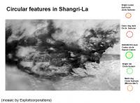
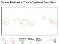
I've put together a list and maps of speculative (perhaps even imaginative) "circular features" in Titan's Equatorial Dune Seas. Some of these appear to have been squished in a particular direction (indicated by the black arrow in the second slide of each set).
Here are the circular features I've imagined in Fensal-Quivra-Aztlan-Aaru region:
And here are the circular features I've imagined in Shagri-La/E Belet region:
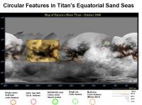
Here is a global map of Titan with the imagined circle features in the Equatorial Dune Seas indicated:
I've put all this data in an attached EXCEL file. These show the named area, the inner diameter (for bright center features this is the diameter of the bright center, or dark centers this is the diameter of the dark center), and the outer diameter (for dark halo features this is the outer limit of the dark zone, for impact craters this is the diameter of the bright ejecta zone). Both the long axis and short axis are entered. (If the craters are not squished, they are the same). If the craters appear squished, I've noted the vector of the compression from North = 0. I've classified them into five morphology types: bright center dark halo circle features (bright center by ISS or RADAR) outer dark halo only (no bright center) multi ring circle features (maybe like Minrva, or maybe not) dark center bright rim (actually apron) impact craters bright rim craters (eroded impact craters?) I've also calculated the ratio of inner/outer rim diameters (using the longest axis), as well as the "squish factor" by dividing inner(long) diameter/inner(short) diameter as well as outer(long)/outer(short) diameters) The EXCEL file is available here:  Equatorial_Sand_Sea_Crater_Morphology_20070606.xls ( 31.5K )
Number of downloads: 321
Equatorial_Sand_Sea_Crater_Morphology_20070606.xls ( 31.5K )
Number of downloads: 321Happy sorting and data analysis! Enjoy! -Mike -------------------- Some higher resolution images available at my photostream: http://www.flickr.com/photos/31678681@N07/
|
||||||||
|
|
|
||||||||
|
Jun 7 2007, 12:56 AM
Post
#86
|
|
|
Senior Member Group: Moderator Posts: 3233 Joined: 11-February 04 From: Tucson, AZ Member No.: 23 |
The problem is that most of those are oblong features, not circular features and I think it is doubtful those are actually impact features.
-------------------- &@^^!% Jim! I'm a geologist, not a physicist!
The Gish Bar Times - A Blog all about Jupiter's Moon Io |
|
|
|
|
Jun 7 2007, 01:07 AM
Post
#87
|
|
|
Senior Member Group: Moderator Posts: 2785 Joined: 10-November 06 From: Pasadena, CA Member No.: 1345 |
Yup. I think you're right. Most the features may have an entirely different (non-impact) type of origin
I find it interesting how the apparent compression seems to be parallel for many of the "features" (similar generation?) I also find it interesting how the compression in the Shangri-La basin seems to be perpindicular to the long parallel ridges. Did a later tectonic extension squish originally circular features into oblong shapes? If it is not impact, it's probably cryovolcanic (or cooler diapir). Do you have any idea of a cryovolcanic process that could cause a depression to make the outer dark halo? (Thermal plume?) -Mike (P.S. There is one feature that I'll bet is an actual impact feature: -22 S, 340 W in W Senkyo. In my imagination it has a dark center, but a broad bright circular apron in ISS. ). -------------------- Some higher resolution images available at my photostream: http://www.flickr.com/photos/31678681@N07/
|
|
|
|
|
Jun 7 2007, 09:40 AM
Post
#88
|
|
|
Senior Member Group: Members Posts: 3516 Joined: 4-November 05 From: North Wales Member No.: 542 |
Where do you find the time, Mike???? Anyhow thanks for that spreadsheet- the one download was me.
|
|
|
|
|
Jun 7 2007, 06:50 PM
Post
#89
|
|
|
Senior Member Group: Moderator Posts: 2785 Joined: 10-November 06 From: Pasadena, CA Member No.: 1345 |
QUOTE (ngunn @ Jun 7 2007, 05:40 AM) Where do you find the time, Mike???? Science never sleeps.  -Mike (Actually, at 90 F and 90% humidity, spending weekends gardening in the hot sun seems less attractive than thinking about a frozen world without ticks, mosquitoes, or browsing deer...) -------------------- Some higher resolution images available at my photostream: http://www.flickr.com/photos/31678681@N07/
|
|
|
|
|
Jun 14 2007, 02:49 PM
Post
#90
|
||||
|
Senior Member Group: Moderator Posts: 2785 Joined: 10-November 06 From: Pasadena, CA Member No.: 1345 |
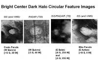
Approximately 60% (30 out of 50) of the circular/oval features in the EXCEL table from post 85 (above) can be described as bright center dark halo circular features.
Here are a few examples by ISS, RADAR and RADAR/ISS imaging:
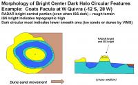
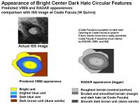
From the supposed deposition sequence and topology above, the ISS brightness is assumed to be terrain that was above the high methane mark during the last big inundation (after bright stuff was deposited). The RADAR brightness is assumed to be due to rough terrain. So: ISS bright, RADAR bright center = rough terrain left high and dry during last inundation. ISS dark, RADAR dark = smooth low lying terrain where bright stuff was dissolved/modified/washed away during the last inundation. (Either low lying dune sands (VIMS dark brown) or ice sands (VIMS dark blue)). Most likely, the bright center dark halo circular features have a rough central plateau or dome surrounded by a smooth depression. Taking Coats Facula as an example, here are images showing hypothetical makeup that could explain the observed morphology:
(Coats Faculas opening is downwind, thus dune sands were not able to penetrate into the dark halo. VIMS imaging of Coats Facula shows that the halo consists of dark blue ice sands. Other halo depressions where dune sands can easily penetrate should appear dark brown by VIMS). The proposed deposition sequence is the same as in post 21 (in this thread), except instead of the word crater substitute the awkward phrase bright center dark halo circular feature. -Mike -------------------- Some higher resolution images available at my photostream: http://www.flickr.com/photos/31678681@N07/
|
|||
|
|
|
|||
|

|
Lo-Fi Version | Time is now: 5th June 2024 - 10:30 PM |
|
RULES AND GUIDELINES Please read the Forum Rules and Guidelines before posting. IMAGE COPYRIGHT |
OPINIONS AND MODERATION Opinions expressed on UnmannedSpaceflight.com are those of the individual posters and do not necessarily reflect the opinions of UnmannedSpaceflight.com or The Planetary Society. The all-volunteer UnmannedSpaceflight.com moderation team is wholly independent of The Planetary Society. The Planetary Society has no influence over decisions made by the UnmannedSpaceflight.com moderators. |
SUPPORT THE FORUM Unmannedspaceflight.com is funded by the Planetary Society. Please consider supporting our work and many other projects by donating to the Society or becoming a member. |
|