

Journey to Mt Sharp - Part 5: Into the Valleys, Sol 706-752, Aug 1-Sep 17, 2014 |

  |
Journey to Mt Sharp - Part 5: Into the Valleys, Sol 706-752, Aug 1-Sep 17, 2014 |
 Sep 26 2014, 08:55 PM Sep 26 2014, 08:55 PM
Post
#376
|
|
|
Newbie  Group: Members Posts: 2 Joined: 26-September 14 Member No.: 7266 |
QUOTE (fredk @ Sep 23 2014, 07:06 PM)  Elsewhere, it's unusual to see this much hue variation in one image: 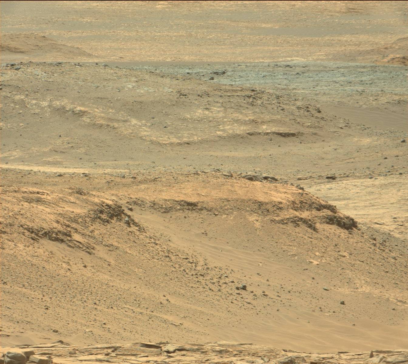 Some of that may be due to dust in the distance, but there are clearly real variations there. Don't the colors and dark appearance of the distant materials resemble that of some rocks in Curiosity close-up pictures where dust does not cover everything? |
 |
 
|
|
Sep 26 2014, 09:38 PM
Post
#377
|
|
|
Senior Member Group: Members Posts: 3516 Joined: 4-November 05 From: North Wales Member No.: 542 |
I think that's true. We have learnt to expect the red stuff here to be only skin deep. For sure, dunes that are on the move are greyer and darker. But fredk's image doesn't show blue-grey dunes, it appears to show different colours of bedrock.
Why would a particular rock surface remain less red? Differences in composition? Differences in dust adherence properties? Differences in local winds? Who knows. Pahrump appears very different from its surroundings despite the ubiquitous dust. I'm sure this rover will provide the answers (with a bit of help from the others). |
|
|
|
|
Sep 27 2014, 09:56 AM
Post
#378
|
|
 Member Group: Members Posts: 819 Joined: 3-June 04 From: Brittany, France Member No.: 79 |
I stitched together the amazing MC100 pictures of layered rocks encountered on sol 751:
 Higher version available on Gigapan. -------------------- |
|
|
|
|
Sep 27 2014, 02:46 PM
Post
#379
|
|
|
Newbie Group: Members Posts: 2 Joined: 26-September 14 Member No.: 7266 |
QUOTE (ngunn @ Sep 26 2014, 04:38 PM) Why would a particular rock surface remain less red? Differences in composition? Differences in dust adherence properties? Differences in local winds? Who knows. Pahrump appears very different from its surroundings despite the ubiquitous dust. I'm sure this rover will provide the answers (with a bit of help from the others). Is Curiosity scheduled to actually enter the dark area, or will it only observe from a distance? |
|
|
|
|
Sep 27 2014, 08:09 PM
Post
#380
|
|
|
Senior Member Group: Members Posts: 3516 Joined: 4-November 05 From: North Wales Member No.: 542 |
QUOTE (hld @ Sep 27 2014, 03:46 PM) Is Curiosity scheduled to actually enter the dark area We've travelled many kilometres southwestward to gain access to the mountain without having to cross the mobile dunefield. |
|
|
|
|
Sep 27 2014, 08:28 PM
Post
#381
|
|
|
Solar System Cartographer Group: Members Posts: 10226 Joined: 5-April 05 From: Canada Member No.: 227 |
Yes indeed, we don't cross it, but we will pass right beside it:
http://mars.nasa.gov/msl/images/NASA-MSL-M...a18475-full.jpg so we will see it close up and probably get at least ChemCam on it. Phil -------------------- ... because the Solar System ain't gonna map itself.
Also to be found posting similar content on https://mastodon.social/@PhilStooke Maps for download (free PDF: https://upload.wikimedia.org/wikipedia/comm...Cartography.pdf NOTE: everything created by me which I post on UMSF is considered to be in the public domain (NOT CC, public domain) |
|
|
|
|
Oct 24 2015, 04:35 PM
Post
#382
|
|
|
Member Group: Members Posts: 293 Joined: 22-September 08 From: Spain Member No.: 4350 |
Just going back to the sol 707 dark streaks discussed on page 7 of this thread (e.g. https://d2cj35nmzi9erd.cloudfront.net/msl/m...DXXX&s=707), in light of recent news about dark streaks and salt deposits, would the ones captured by Curiosity be looked at differently?
|
|
|
|
|
Oct 31 2015, 07:55 PM
Post
#383
|
|
|
Member Group: Members Posts: 306 Joined: 4-October 14 Member No.: 7273 |
I don't think so. There are a few arguments to be made against it being an RSL-like feature.
- I think the strongest argument is that once you get beneath a bright layer on top, the sand is actually very dark. Compare to some of Curiosity's wheel tracks taken the same Sol. This is because over time, an "average" of Martian dust slowly settles out of the atmosphere to blanket the darker material. Another observation is that the dark streaks on the slope start at prominent vertical cracks in the rock that also poke out at the top of the outcrop. So it's likely that sand is funneling into these cracks as wind pushes it around, slowly building up until it becomes unstable, and then slipping down the slope and exposing the darker dust underneath. A couple of weaker arguments: - Most of the major RSL sites on Mars seem like they're connected to major bedrock cliffs. To me, that is indicating that either RSLs are receiving at least a little contribution from groundwater systems *or* groundwater systems in the past deposited the perchlorate salts that allow the formation of RSLs from atmospheric moisture. The dark streak here is associated with what appears to be a relatively recent valley, so I don't think the conditions are favorable to form an RSL here. But, there's been possible RSLs observed elsewhere in Gale Crater so this is a very loose constraint. - From looking at terrestrial analogues of RSLs at Don Juan Pond in Antarctica, they don't seem to have sharply defined edges - they're kind of fuzzy! I think the fairly sharp edges we see on RSLs from orbital data are a resolution artifact. Since we only see the average brightness of a square meter or so on the surface from orbit, we don't see the features fading out near the edges, so they look sharper than they really are. I'd also need to check on the season those were taken (does anyone have a Mars seasonal calendar?) - if they were taken in the fall or winter they're unlikely to be RSLs. Unfortunately, another instrument which would have been extremely helpful in helping figure this question out, a relative humidity sensor, got broken during the landing sequence. This question would be so much easier to get a definitive answer on if we could tell if the weeks leading up to this find were humid or not. I hope that answers your question! |
|
|
|
|
Oct 31 2015, 08:41 PM
Post
#384
|
|
|
Merciless Robot Group: Admin Posts: 8785 Joined: 8-December 05 From: Los Angeles Member No.: 602 |
Actually, I think that the wind sensor was damaged but not the humidity sensor. That link is from an old article written just a few weeks after landing, though; anybody have more recent info?
-------------------- A few will take this knowledge and use this power of a dream realized as a force for change, an impetus for further discovery to make less ancient dreams real.
|
|
|
|
|
Oct 31 2015, 08:47 PM
Post
#385
|
|
|
Member Group: Members Posts: 306 Joined: 4-October 14 Member No.: 7273 |
I'd checked the REMS homepage and the the humidity wasn't reporting and the graph showing the relative humidity over time wasn't displaying any data. I just assumed that the relative humidity meter was one of the broken weather instruments. But looking it, it does appear that it's been collecting data. Now just to figure out where that data is stored and I can put together a quick graph showing what the humidity was doing in the weeks leading up to that find...
|
|
|
|
|
Oct 31 2015, 10:54 PM
Post
#386
|
|
|
Senior Member Group: Members Posts: 1056 Joined: 17-February 09 Member No.: 4605 |
NASA did indicate in a news release that the relative humidity measured by Curiosity varies between some 5% on a summer afternoon to 100% on autumn and winter nights. http://www.jpl.nasa.gov/news/news.php?
While this indicates saturation conditions at night I cannot recall any indication that Curiosity has imaged frost although this was a nominated task for mastcam and MAHLI. Does anyone know the absolute humidity value as relative humidity only indicates the saturation value, not the amount of water available in the atmosphere? In any case I believe that for these perchlorates the deliquescence boundary is less than 60% and greater than 20% relative humidity above some 200K, yet TECP (Phoenix) failed to locate any indication of brines or liquid in the regolith despite what were pretty much optimal conditions. |
|
|
|
|
Nov 1 2015, 01:34 AM
Post
#387
|
|
 Senior Member Group: Members Posts: 2431 Joined: 30-January 13 From: Penang, Malaysia. Member No.: 6853 |
The analyst's notebook contains a REMS data file and a header LBL for sol 707, as do many of the adjacent sols.
Link : https://an.rsl.wustl.edu/msl/mslbrowser/ Maybe those files will contain the data you are looking for? Edit, this paper only covers the first 360 sols of the mission, from landing to Yellowknife Bay... But it may help you find follow up papers or data. Mars Science Laboratory relative humidity observations: Initial results. http://www.ncbi.nlm.nih.gov/pmc/articles/P...re0119-2132.pdf |
|
|
|
|
Nov 1 2015, 11:57 PM
Post
#388
|
|
|
Senior Member Group: Members Posts: 1056 Joined: 17-February 09 Member No.: 4605 |
Thanks for posting that link to the article Paul, it is really interesting. When we are considering a precipitable water content of 3 to 6 microns the amount that would be actually precipitated at the surface would be really minuscule. The maximum RH of 50% over 100 sols combined with around 0.5% perchlorate concentration in the regolith would limit deliquescence and any brines formed would be microscopic and potentially would not coalesce. jccwrt's nomination of dry slippage revealing darker underlying regolith is a pretty convincing explanation for the darkish streaks at Gale.
|
|
|
|
|

|
Lo-Fi Version | Time is now: 21st September 2024 - 08:40 PM |
|
RULES AND GUIDELINES Please read the Forum Rules and Guidelines before posting. IMAGE COPYRIGHT |
OPINIONS AND MODERATION Opinions expressed on UnmannedSpaceflight.com are those of the individual posters and do not necessarily reflect the opinions of UnmannedSpaceflight.com or The Planetary Society. The all-volunteer UnmannedSpaceflight.com moderation team is wholly independent of The Planetary Society. The Planetary Society has no influence over decisions made by the UnmannedSpaceflight.com moderators. |
SUPPORT THE FORUM Unmannedspaceflight.com is funded by the Planetary Society. Please consider supporting our work and many other projects by donating to the Society or becoming a member. |
|


