Spirit Route Map, Small and Large Scales |

  |
Spirit Route Map, Small and Large Scales |
 Jan 28 2007, 08:31 AM Jan 28 2007, 08:31 AM
Post
#496
|
|
 Senior Member  Group: Members Posts: 3419 Joined: 9-February 04 From: Minneapolis, MN, USA Member No.: 15 |
I also think there are likely differences in the softness, bearing strength, etc., of the hills unit(s) as opposed to the plains unit. The lava plains are full of hard basalt, which erodes slowly and retains its cratering record better than the softer rocks that make up much of the hills. Remember, one of the first things we saw when we reached the hills unit was a rock that had literally rotted away from the inside, leaving only the more resistant weathering rind. That makes it look a lot like the rocks that make up the hills are *much* softer than the lava plains. (RAT experience also confirms this.)
As for crater counts -- the crater count at the Taurus-Littrow site visited by Apollo 17 was relatively low, indicating a rather young surface. Definitely younger than the Serenatatis plains. What they discovered was a surface just as old as the surrounding plains, but mixed with a significantly greater amount of glass. The glass made the regolith softer, and it retained its cratering record more poorly than surfaces which had not been mixed with as much glass. Crater counts falsely made the surface appear young because that particular part of the Moon doesn't retain its small craters as well as most other parts. The Apollo 17 lesson is clear -- crater counts are only indicative of relative ages on surfaces which have similar capabilities to retain their cratering record. Comparing crater counts between softer and harder surfaces isn't always indicative of relative age. Besides, it's visibly obvious that the lava plains postdate the hills. They are embayed against the hills. The view from only a dozen meters up Husband Hill gave rather stark proof of that. However, I am continually intrigued by the semi-circular "cut" in the ridge that forms Ramon Hill's crest. It looks for all the world to me like the hills were uplifted such that the surface angled up along the east side of the Columbia Hills ridge, and the circular bite out of the ridge is the nearly unrecognizable remnant of a crater rim in the pre-uplift ancient surface... -the other Doug -------------------- The trouble ain't that there is too many fools, but that the lightning ain't distributed right. -Mark Twain
|
 |
 
|
|
Jan 29 2007, 11:42 AM
Post
#497
|
|
|
Senior Member Group: Members Posts: 1870 Joined: 20-February 05 Member No.: 174 |
"I also think there are likely differences in the softness, bearing strength, etc., of the hills unit(s) as opposed to the plains unit. ..." etc.
I entirely agree. One of the problems in interpreting geology of old terrains like the hills is that their exposed relief is a complex mix of 1) original geologic structure, 2) weathering/alteration damage to the physical properties of the original materials that form the structures <ie the rotted rock>, and 3) internal/external modification of the original structures (intrusions, any uplift or faulting, and large and small cratering), all eventually 4) "etched" eroded by poorly understood mechanical and perhaps chemical weathering process, while being 5) overlaid by obscuring sheets of dust and sand, themselves modified by internal <salt concentrating, etc. processes. To put it more simply, the hills are a *MESS* that would take far more sophisticated rovers with better sampling, remote viewing, and subsurface souinding instruments, operating far faster for a few decades to thoroughally unravel. Considering... we're making a damn good start. |
|
|
|
|
Jan 29 2007, 01:09 PM
Post
#498
|
||
|
Senior Member Group: Moderator Posts: 4279 Joined: 19-April 05 From: .br at .es Member No.: 253 |
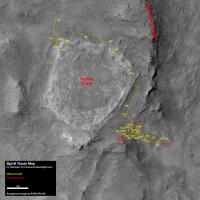
Updated route map (sol 1092).
|
|
|
|
|
|
|
Jan 29 2007, 02:07 PM
Post
#499
|
|
|
Senior Member Group: Members Posts: 2920 Joined: 14-February 06 From: Very close to the Pyrénées Mountains (France) Member No.: 682 |
I'm wondering, Eduardo, if you can add a smaller scale in the legend on your route map. For exemple, it's very hard to figure out easily if Spirit moved 2?, 3?, 5? meters last time she moved. And I guess she'll not going to move long distances anymore. Thanks
Edit : Ouuups, I misred 200 m instead of 20 but anyway, a small bar at 5 -10 -15 will be helpfull to me. -------------------- |
|
|
|
|
Jan 31 2007, 10:44 AM
Post
#500
|
||
|
Senior Member Group: Moderator Posts: 4279 Joined: 19-April 05 From: .br at .es Member No.: 253 |
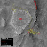
Updated route map (sol 1094).
 The next update should include something new on that direction. ... if I don't forget again! The next update should include something new on that direction. ... if I don't forget again!  In the meantime, just say that the map resolution is 10pix/m. Edited: I found that the current position was not properly plotted. Just compare this fhazcam from tosol (1094) with this other one from sol 779 and you'll see that Spirit is now almost exactly at the same spot it was on that sol. Map updated accordingly. BTW, it now includes a different ruler. Climber, me debes una cerveza! This post has been edited by Tesheiner: Jan 31 2007, 02:42 PM |
|
|
|
|
|
|
Jan 31 2007, 02:37 PM
Post
#501
|
||
|
Founder Group: Chairman Posts: 14432 Joined: 8-February 04 Member No.: 1 |
A scale bar - 10 pixels then 50 pixels. (i.e. 1m then 5m)
Doug
Attached thumbnail(s)
|
|
|
|
|
|
|
Jan 31 2007, 02:43 PM
Post
#502
|
|
|
Senior Member Group: Moderator Posts: 4279 Joined: 19-April 05 From: .br at .es Member No.: 253 |
Too late Doug.
|
|
|
|
|
Jan 31 2007, 05:42 PM
Post
#503
|
|
|
Senior Member Group: Members Posts: 2920 Joined: 14-February 06 From: Very close to the Pyrénées Mountains (France) Member No.: 682 |
QUOTE (Tesheiner @ Jan 31 2007, 11:44 AM)  Climber, me debes una cerveza! No tengo anotado cuantas te debes
-------------------- |
|
|
|
|
Feb 2 2007, 09:43 PM
Post
#504
|
||
|
Senior Member Group: Moderator Posts: 4279 Joined: 19-April 05 From: .br at .es Member No.: 253 |
Updated route map (sol 1096).
|
|
|
|
|
|
|
Feb 7 2007, 03:49 AM
Post
#505
|
|
 Senior Member Group: Members Posts: 4246 Joined: 17-January 05 Member No.: 152 |
A new "route map" of sorts in spirit press images. It shows many features overlaid on the McMurdo pan.
An excellent resource for the most part, but I have to point out one error - they label a piece of the Thira crater rim visible to the east. We determined (recall this post) that that was actually a piece of the rim of Gusev itself. |
|
|
|
|
Feb 7 2007, 04:48 AM
Post
#506
|
|
 Senior Member Group: Moderator Posts: 2262 Joined: 9-February 04 From: Melbourne - Oz Member No.: 16 |
Easy mistake to make!

-------------------- |
|
|
|
|
Feb 7 2007, 11:43 AM
Post
#507
|
|
 Special Cookie Group: Members Posts: 2168 Joined: 6-April 05 From: Sintra | Portugal Member No.: 228 |
QUOTE (jamescanvin @ Feb 7 2007, 04:48 AM) Easy mistake to make! 
-------------------- "Ride, boldly ride," The shade replied, "If you seek for Eldorado!"
Edgar Alan Poe |
|
|
|
|
Feb 7 2007, 04:14 PM
Post
#508
|
|
|
Solar System Cartographer Group: Members Posts: 10151 Joined: 5-April 05 From: Canada Member No.: 227 |
Another problem - the feature labelled West Spur is actually a nearer, south-pointing projection of Husband Hill. It was called Lookout Point on early maps of the hills. West Spur is behind it and not visible.
But - a very nice image. I would like to have this for every big panorama from the whole mission. Phil -------------------- ... because the Solar System ain't gonna map itself.
Also to be found posting similar content on https://mastodon.social/@PhilStooke Maps for download (free PD: https://upload.wikimedia.org/wikipedia/comm...Cartography.pdf NOTE: everything created by me which I post on UMSF is considered to be in the public domain (NOT CC, public domain) |
|
|
|
|
Feb 7 2007, 06:39 PM
Post
#509
|
|
|
Senior Member Group: Members Posts: 4246 Joined: 17-January 05 Member No.: 152 |
You're absolutely right Phil - that's not west spur. It appears to me that their location for the lander is about right though.
|
|
|
|
|
Feb 8 2007, 03:21 PM
Post
#510
|
||
|
Senior Member Group: Moderator Posts: 4279 Joined: 19-April 05 From: .br at .es Member No.: 253 |
Updated route map (sol 1102).
I just hope they don't follow the same path used to get from the winter haven to Tyrone now on the way back to Home Plate, otherwise this map will become a real mess. 
|
|
|
|
|
|
|

|
Lo-Fi Version | Time is now: 24th April 2024 - 10:23 PM |
|
RULES AND GUIDELINES Please read the Forum Rules and Guidelines before posting. IMAGE COPYRIGHT |
OPINIONS AND MODERATION Opinions expressed on UnmannedSpaceflight.com are those of the individual posters and do not necessarily reflect the opinions of UnmannedSpaceflight.com or The Planetary Society. The all-volunteer UnmannedSpaceflight.com moderation team is wholly independent of The Planetary Society. The Planetary Society has no influence over decisions made by the UnmannedSpaceflight.com moderators. |
SUPPORT THE FORUM Unmannedspaceflight.com is funded by the Planetary Society. Please consider supporting our work and many other projects by donating to the Society or becoming a member. |
|