Titan's Mid-Latitudes, Into the Temperate Blandlands |

  |
Titan's Mid-Latitudes, Into the Temperate Blandlands |
 May 22 2008, 01:47 AM May 22 2008, 01:47 AM
Post
#1
|
|||||
 Senior Member  Group: Moderator Posts: 2785 Joined: 10-November 06 From: Pasadena, CA Member No.: 1345 |
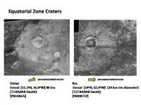
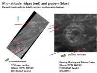
I put together a sequence of craters of similar erosion state (Recent or Fresh)starting from the Equatorial Zones up to the higher latitudes. Presumed average wind direction based on presumed drifts is indicated.
The Equatorial zone craters in the Sand Sea basins, like Ksa and Sinlap, have clear rims, interiors and debris aprons. Dunes are at the margins.
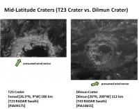
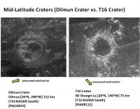
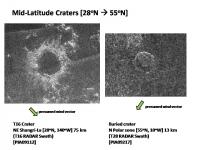
Further north, the T23 Crater which sits in Fensal basin, has a clear rim and debris apron, although the surrounding terrain has slightly RADAR-brighter wispiness (drifts?) as downwind streaks. The recently released image of the Dilmun Crater at the same latitude, but on a bright area, has the same RADAR-brighter wispiness as downwind streaks and symmetrically placed at the edges of the windshadow of the crater. The Dilmun Crater also looks very similar to the circular feature seen in the T16 Swath. I'd be pretty confident calling the T16 circular feature an impact crater based on it's similarity to the Dilmun Crater. [The streak to the left of the T16 crater is the RADAR SAR seam, other RADAR-bright streaks are in the immediate area and are downwind. Wind coming from the upper left in the image] The interior rim is also similarly crenellated. The T16 Crater is very similar to the Dilmun crater, but slightly buried so that the margin of the debris apron is less distinct. The T23, Dilmun, and T16 craters are all at about 30N. Above this latitude there are very few identified craters.
The next graphic shows a circular feature at 58N latitude. Extrapolating the trend from Equatorial regions to the higher latitudes, we would expect it to be buried - which it appears. Only the rim is clearly visible. Topograpy seems to show that the center has been almost completely infilled. At least with this limited sample, the trend is for craters to have subtle RADAR bright windstreaks and to become progressively buried as one goes from the Equatorial zones to the higher latitudes. -Mike -------------------- Some higher resolution images available at my photostream: http://www.flickr.com/photos/31678681@N07/
|
||||
 |
 
|
||||
|
May 23 2008, 05:48 AM
Post
#2
|
|||
|
Senior Member Group: Moderator Posts: 2785 Joined: 10-November 06 From: Pasadena, CA Member No.: 1345 |
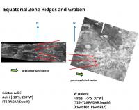
I put together a sequence showing changes in pattern of tectonic ridges/graben going from the Equatorial Sand Seas to higher latitudes. These image are grouped to show the pattern change as one moves to higher latitudes.
In the Equatorial Sand Seas, the tectonic ridges stand proud, as seen in T8 across Adiri. Inland portions, such as W Quivira in the T25/T28 mosaic in the graphic, show the ridges, and also graben between the ridges. The ridges are RADAR bright, while the graben are RADAR dark (smooth muds). Red arrows indicate the ridge lines. The average wind vector based on dunes or drift patterns is also shown.
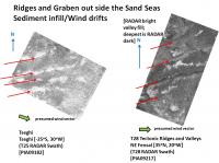
Moving away from the Sand Sea basins, the T25 Swath in Tseghi shows bright ridge patterns (the graben are better viewed by ISS and VIMS). In the bright terrain margin in NE Fensal, the T28 RADAR swath shows a series of tectonic ridges, a surrounding RADAR dark grey deposit mantle (presumably higher elevation), then a lighter grey wind deposit (evidenced by mid-latitude RADAR bright dunes) and finally a RADAR darker grey valley floor deposit. More details on the T28 image can be found here (The Mountains of Titan thread, post 6). The T28 Swath hints at patterns in higher latitudes. -Mike -------------------- Some higher resolution images available at my photostream: http://www.flickr.com/photos/31678681@N07/
|
||
|
|
|
||
|
May 23 2008, 05:53 AM
Post
#3
|
||||
|
Senior Member Group: Moderator Posts: 2785 Joined: 10-November 06 From: Pasadena, CA Member No.: 1345 |
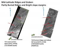
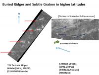
Further away from the Equatorial Sand Sea margin, the dune sands disappear and are replaced by gentle RADAR-bright wind drifts that continue to indicate the averaged wind vector around bright uplands. This is seen in the T28 and T21 swaths, although at different latitudes. A detail of the section indicated in green is shown in the next graphic.
In this zoomed area, the RADAR units are indicated by a color overlay. The brightest RADAR reflection comes from the bright upland terrain, these are probably sections of tectonic ridge poking up above the drifts. Downwind of this is an area of RADAR dark smooth terrain. At the margins of the dark smooth upland terrain, is a RADAR brighter terrain (although still grey). RADAR-bright drifts are seen in some sections of this terrain. These drifts also go around the RADAR-darker terrain, further evidence that the RADAR dark terrain is upland terrain. Below the bright margin wind-drift terrain, there is a slightly RADAR darker terrain, this seems to be valley fill. In areas close to the Sand Sea margins, dark channels can be seen to come from the valley mouths. This is evident , but hard to see in T21, but it is very evident in the lower section of the T28 tectonic ridges that are closer to Fensal. Here is the sequence from highest altitude to lowest in the Basin margin Mid-latitudes.
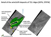
In some areas the RADAR bright tectonic ridges are not seen (burial?) and the dark channel features may not be seen either. In this case the bright grey wind drift margin terrain is the most obvious, and it will be necessary to look at the pattern of the darker material to see if it corresponds to windshadow/upland or to valley fill. In general, upland will lie downwind of the concave face of the bright wind drift margin, while valley fill will lie upwind of the concave face of the bright wind-drift margin.
In the graphic above for the T21 Swath and the recently released T43 Dilmun crater image, the upper ridges are indicated by red arrows, while the valley floors are indicated by blue arrows. By analogy with Tseghi, Ill speculate that the Dancing Monkey feature is a series of intersecting graben that just happen to lie at the level and close enough to the Sand Sea margin to be infilled with Deep Black unit material (with very little dune sands). Like Shiwanna Virgae, Ill further predict that this feature will be very evident by VIMS (2.7/2.8 um ratiod image). Ill predict that this graben structure extends well beyond the SW and NE ISS-visible borders of the feature, but that the lack of deep infill decreases contrast. Ill also predict that more features like the Dancing Monkey will be observed in areas marginal to the Sand Sea basins. A great place to look for these would be in NE Shangri-La, as well as in N Belet, north of the Cyclops dude feature. [SE Adiri, Ching-Tu, S Senkyo are also likely targets for this type of feature]. -Mike -------------------- Some higher resolution images available at my photostream: http://www.flickr.com/photos/31678681@N07/
|
|||
|
|
|
|||
|
May 23 2008, 05:57 AM
Post
#4
|
||
|
Senior Member Group: Moderator Posts: 2785 Joined: 10-November 06 From: Pasadena, CA Member No.: 1345 |
In the graphic below, only the ridges are evident by RADAR (burial?) in the T21 image at about 30 N, while even further up at 50 N, the Polar Stripes of Titan seen in T30 RADAR Swath (also in T21 Swath) appear to be RADAR-dark surrounded by a brighter wind-drift margin.
It would appear that Titans Polar Stripes are valley fill. Ill predict that VIMS will show this to be filled with the Deep Black unit. -Mike -------------------- Some higher resolution images available at my photostream: http://www.flickr.com/photos/31678681@N07/
|
|
|
|
|
|
|
Dec 20 2008, 05:46 PM
Post
#5
|
|||
|
Senior Member Group: Moderator Posts: 2785 Joined: 10-November 06 From: Pasadena, CA Member No.: 1345 |
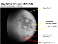
New Southern Basin on Titan S of Senkyo?
Recent released image on planetary photojournal: PIA10536 I fumbled around with additional processing of the image to increase the contrast in the southern regions (subtracted a funky gradient, stretched contrast using a variable mask, etc..). I don't think I introduced too many artifacts...
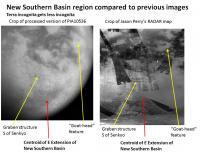
The Playboy peninsula is at center, S Senkyo basin just to the E. Going S, there is the graben-like terrain previously discussed in some recent abstracts (Sotin et al. LPSC 38 (2007 Abstract 2444; Perry et al. LPSC 38 (2007) Abstract 2219.) Further S, there appears to be a darker toned region (schizzle-covered basin?) with some brighter blobby islands to the W. These islands would form the break between the New Southern Basin and Mezzoramia to the W. Here is an crop of this area along with the previously best released image I could find (from the RADAR swath map made by VP):
-Mike -------------------- Some higher resolution images available at my photostream: http://www.flickr.com/photos/31678681@N07/
|
||
|
|
|
||
|
Mar 14 2009, 07:30 PM
Post
#6
|
|
|
Senior Member Group: Moderator Posts: 2785 Joined: 10-November 06 From: Pasadena, CA Member No.: 1345 |
Recent article in Icarus:
Janssen, M.A. et al. Icarus 200 (2009) 222-239. "Titan's surface at 2.2-cm wavelength imaged by Cassini RADAR radiometer: Calibration and first results." doi: 10.1016/j.icarus.2008.10.017 The article presents a global dielectric constant and brightness temperature map. Here is a key quote plucked out of the article: "Much of the surface, particularly away from the equatorial region, is relatively bland [by dielectric constant and microwave brightness] with low retrieved dielectric constant and ubiquitous but moderate volume scattering. This suggests a common terrain with a relatively low loss surface that enhances the potential for volume scattering, covered by a fluffy or lower density covering that reduces its polarization signature." Titan is "fluffy". -------------------- Some higher resolution images available at my photostream: http://www.flickr.com/photos/31678681@N07/
|
|
|
|
|
Mar 14 2009, 08:01 PM
Post
#7
|
|
|
Senior Member Group: Members Posts: 3516 Joined: 4-November 05 From: North Wales Member No.: 542 |
That fits with a lot of things, including the idea that some of the surface materials could be buoyant on methane floods.
|
|
|
|
|

|
Lo-Fi Version | Time is now: 28th April 2024 - 09:53 AM |
|
RULES AND GUIDELINES Please read the Forum Rules and Guidelines before posting. IMAGE COPYRIGHT |
OPINIONS AND MODERATION Opinions expressed on UnmannedSpaceflight.com are those of the individual posters and do not necessarily reflect the opinions of UnmannedSpaceflight.com or The Planetary Society. The all-volunteer UnmannedSpaceflight.com moderation team is wholly independent of The Planetary Society. The Planetary Society has no influence over decisions made by the UnmannedSpaceflight.com moderators. |
SUPPORT THE FORUM Unmannedspaceflight.com is funded by the Planetary Society. Please consider supporting our work and many other projects by donating to the Society or becoming a member. |
|