Titan's topography, strange.... |

  |
Titan's topography, strange.... |
 Apr 10 2013, 04:11 AM Apr 10 2013, 04:11 AM
Post
#121
|
|
 Senior Member  Group: Members Posts: 2173 Joined: 28-December 04 From: Florida, USA Member No.: 132 |
QUOTE (titanicrivers @ Apr 9 2013, 09:44 PM)  ...I wonder though if that beautiful volcano and lava flow is deserving of a more eloquent name. OS (Oil Spill) Crater?I had to look up the SP name. I love the way the Wikipedia entry describes mapmakers' reluctance to print the actual name.  "...the dark lava spatter on the rim, and the long dark lava flow extruding from the base do indeed resemble a toilet catastrophe. Mapmakers refused to spell out the full name, and the mountain has been shown on maps and other literature with the abbreviated name." |
 |
 
|
|
Apr 10 2013, 05:05 AM
Post
#122
|
|
|
Merciless Robot Group: Admin Posts: 8783 Joined: 8-December 05 From: Los Angeles Member No.: 602 |
Juramike is right; we really don't need to explore this crap any further.
 Moving on... -------------------- A few will take this knowledge and use this power of a dream realized as a force for change, an impetus for further discovery to make less ancient dreams real.
|
|
|
|
|
Apr 18 2013, 07:21 AM
Post
#123
|
|
|
Rover Driver Group: Members Posts: 1015 Joined: 4-March 04 Member No.: 47 |
For those with access to Icarus, Ralph Lorenz et al. made a topographical map of Titan http://www.sciencedirect.com/science/artic...019103513001620
|
|
|
|
|
Apr 18 2013, 04:37 PM
Post
#124
|
|
|
Senior Member Group: Members Posts: 3516 Joined: 4-November 05 From: North Wales Member No.: 542 |
That's great, thanks for posting. Even for those of us without access to the paper the map itself is right there in your link.
|
|
|
|
|
Apr 18 2013, 04:45 PM
Post
#125
|
|
 Senior Member Group: Admin Posts: 4763 Joined: 15-March 05 From: Glendale, AZ Member No.: 197 |
Ironic. A map of a cryogenic world in a publication called Icarus.
-------------------- If Occam had heard my theory, things would be very different now.
|
|
|
|
|
Apr 18 2013, 05:14 PM
Post
#126
|
|
 Senior Member Group: Members Posts: 2530 Joined: 20-April 05 Member No.: 321 |
This looks similar, at global scale, to topographical maps of Mars. I wonder how much that has to do with the spin axis being chosen by the topography, and not vice versa. Or being coincidental.
|
|
|
|
|
Apr 19 2013, 07:40 AM
Post
#127
|
||
|
Member Group: Members Posts: 699 Joined: 1-April 08 From: Minnesota ! Member No.: 4081 |
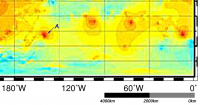
Thanks for the link to the figures and maps. Fig 3 the Interpolated topography map has four elevated areas in the south-eastern quadrant one of which we have recently portrayed in several UMSF posts. http://www.unmannedspaceflight.com/index.p...3168&st=194 The elevated area at 150W and 50S is the dissected plateau of T59 as depicted below.
|
|
|
|
|
|
|
Apr 20 2013, 09:09 AM
Post
#128
|
||
|
Member Group: Members Posts: 699 Joined: 1-April 08 From: Minnesota ! Member No.: 4081 |
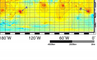
Again starting with Fig 3 the Interpolated topography map, the fourth elevated areas in the south-eastern quadrant (D) has appeared in several UMSF posts and in Photojournal http://photojournal.jpl.nasa.gov/catalog/PIA03565 The elevated area is the dissected plateau of T7 as depicted below.
|
|
|
|
|
|
|
Apr 20 2013, 08:10 PM
Post
#129
|
||
|
Member Group: Members Posts: 699 Joined: 1-April 08 From: Minnesota ! Member No.: 4081 |
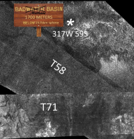
Approximate low spot on Titan at 317W and 59S. Some nice fans or deltas nearby. Data derived from Lorenz et al http://www.sciencedirect.com/science/artic...019103513001620
|
|
|
|
|
|
|
Apr 20 2013, 09:01 PM
Post
#130
|
|
|
Senior Member Group: Members Posts: 2998 Joined: 30-October 04 Member No.: 105 |
QUOTE (Titanicrivers) PIA03565 The elevated area is the dissected plateau of T7 as depicted below. Terrain like that impresses me as the surface expression of ice diapirs.--Bill -------------------- |
|
|
|
|
Apr 21 2013, 06:36 AM
Post
#131
|
|
|
Senior Member Group: Members Posts: 3516 Joined: 4-November 05 From: North Wales Member No.: 542 |
I agree. Taking the SAR image and the topography together that's another persuasive diapir candidate. I also note that 'New Wrinkles' discussed earlier coincides with a topographic rise on the new map.
|
|
|
|
|
Apr 21 2013, 10:45 PM
Post
#132
|
||
|
Member Group: Members Posts: 699 Joined: 1-April 08 From: Minnesota ! Member No.: 4081 |
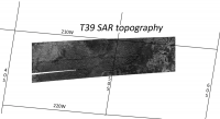
A very nice observation Nigel! Its especially the further south and west new wrinkle that has a topographic high spot on that map. I was also interested in the high spot along the T39 swath located between 40 and 50 S and 210 to 220 W. VP's SAR's for part 1 of T39 show the high point corresponds with highly dissected (labrynthine) terrain with a fluvial valley bordering part of it. SAR topo confirms this is high ground even though so eroded.
|
|
|
|
|
|
|
Apr 22 2013, 12:56 PM
Post
#133
|
|
 Member Group: Members Posts: 610 Joined: 23-February 07 From: Occasionally in Columbia, MD Member No.: 1764 |
QUOTE (remcook @ Apr 18 2013, 02:21 AM) For those with access to Icarus, Ralph Lorenz et al. made a topographical map of Titan Actually, the manuscript, all the figures at high resolution, and the numerical gridded topography data as ascii, are all at http://www.lpl.arizona.edu/~rlorenz/titantopo/ enjoy ! |
|
|
|
|
Apr 22 2013, 04:08 PM
Post
#134
|
|
|
Senior Member Group: Members Posts: 2998 Joined: 30-October 04 Member No.: 105 |
QUOTE enjoy! Indeed. Thanks.Someone-- jog my ailing memory, I don't work with tidally-locked bodies that often-- on longitudes, what is the sub-Saturnian point, and what is the leading hemisphere? I'm thinking that 0* is sub-saturnian, 90* is leading, and so on... --Bill -------------------- |
|
|
|
|
Apr 22 2013, 05:07 PM
Post
#135
|
|
|
Member Group: Members Posts: 699 Joined: 1-April 08 From: Minnesota ! Member No.: 4081 |
QUOTE (rlorenz @ Apr 22 2013, 06:56 AM) Actually, the manuscript, all the figures at high resolution ... enjoy ! These are superb Ralph !! Its is treasure trove for us Titan affectionados. If I may, there is part of the T83 swath containing the possible volcanic structure ('hot-cross bun') that I haven't been able to find and I see you have it in your Fig 9 topo map. Jason Perry has the polar portion of the swath on his web site http://pirlwww.lpl.arizona.edu/~perry/RADAR/#T83 but not the initial portion between 20 and 60 N. Is there a place to download the entire T83 swath? Was there any topographic info to add to 'hot-cross bun' to make its possible volcanic geomorphic status more compelling? Thanks Titanicrivers. EDIT: ditto for the T84 SAR swath ! |
|
|
|
|

|
Lo-Fi Version | Time is now: 26th April 2024 - 05:52 PM |
|
RULES AND GUIDELINES Please read the Forum Rules and Guidelines before posting. IMAGE COPYRIGHT |
OPINIONS AND MODERATION Opinions expressed on UnmannedSpaceflight.com are those of the individual posters and do not necessarily reflect the opinions of UnmannedSpaceflight.com or The Planetary Society. The all-volunteer UnmannedSpaceflight.com moderation team is wholly independent of The Planetary Society. The Planetary Society has no influence over decisions made by the UnmannedSpaceflight.com moderators. |
SUPPORT THE FORUM Unmannedspaceflight.com is funded by the Planetary Society. Please consider supporting our work and many other projects by donating to the Society or becoming a member. |
|