Opportunity Route Map |

  |
Opportunity Route Map |
 Feb 15 2009, 11:08 PM Feb 15 2009, 11:08 PM
Post
#2461
|
|
 Administrator  Group: Admin Posts: 5172 Joined: 4-August 05 From: Pasadena, CA, USA, Earth Member No.: 454 |
Great idea! One typo -- you credit someone named Time Parker
 --Emily -------------------- My website - My Patreon - @elakdawalla on Twitter - Please support unmannedspaceflight.com by donating here.
|
 |
 
|
|
Feb 15 2009, 11:15 PM
Post
#2462
|
|
 Senior Member Group: Moderator Posts: 2262 Joined: 9-February 04 From: Melbourne - Oz Member No.: 16 |
So I did - fixed.
Thanks Emily. -------------------- |
|
|
|
|
Feb 16 2009, 05:18 AM
Post
#2463
|
|
|
Senior Member Group: Members Posts: 1018 Joined: 29-November 05 From: Seattle, WA, USA Member No.: 590 |
Thanks, James. I was hoping someone would do that. The local maps are great, but on the long trek, it's really nice to see the big picture from time to time.
--Greg |
|
|
|
|
Feb 16 2009, 06:59 AM
Post
#2464
|
|
|
Senior Member Group: Moderator Posts: 4279 Joined: 19-April 05 From: .br at .es Member No.: 253 |
Good idea James, specially the one with the ripple map.
> The local maps are great, but on the long trek, it's really nice to see the big picture from time to time. Local maps ... big picture ... Now, whould you imagine telling that to the MER team during the nominal mission? 
|
|
|
|
|
Feb 19 2009, 09:50 AM
Post
#2465
|
||
|
Senior Member Group: Moderator Posts: 4279 Joined: 19-April 05 From: .br at .es Member No.: 253 |
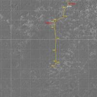
Here we go with another map update: Sol 1803.
 Route_Map_Sol1803.kml ( 12.34K )
Number of downloads: 532
Route_Map_Sol1803.kml ( 12.34K )
Number of downloads: 532 |
|
|
|
|
|
|
Feb 22 2009, 07:52 AM
Post
#2466
|
|
|
Senior Member Group: Moderator Posts: 4279 Joined: 19-April 05 From: .br at .es Member No.: 253 |
|
|
|
|
|
Feb 23 2009, 10:34 AM
Post
#2467
|
|
 Junior Member Group: Members Posts: 73 Joined: 10-May 06 From: Spain Member No.: 770 |
Hello to all, although I read the forum for some time had never written before.
Tesheiner, the layer of your Route Map for Google Earth must be downloaded each time or if I keep the layer will be updated automatically? In Google Earth, the Mars view has a layer with the path of the Opportunity, which has differences with yours. Why are these differences? Greetings |
|
|
|
|
Feb 23 2009, 11:03 AM
Post
#2468
|
|
|
Founder Group: Chairman Posts: 14431 Joined: 8-February 04 Member No.: 1 |
The one that works via Google is less accurate than Eduardo's. It's also updated less often. I would trust Eduardo's over everything apart from JPL et.al.
|
|
|
|
|
Feb 23 2009, 11:42 AM
Post
#2469
|
|
|
Senior Member Group: Moderator Posts: 4279 Joined: 19-April 05 From: .br at .es Member No.: 253 |
Welcome to UMSF, Dig.
> Tesheiner, the layer of your Route Map for Google Earth must be downloaded each time or if I keep the layer will be updated automatically? You should download it every time you see an update here. > In Google Earth, the Mars view has a layer with the path of the Opportunity, which has differences with yours. Why are these differences? Good question. First of all, I presume you are talking about the different (x,y) positions for a given site in both paths. IMO the difference is probably due to a different translation from (x,y) coordinates to lat/long. I'm keeping track of the route on a map-projected picture (HiRISE image PSP_009141_1780 in the route map you see here in JPG format) and the process to plot a position on that picture is in a way manual and results in (x,y) coordinates which are good for that image. Now, I'm creating the KML layer for GE automatically using a VB tool and converting the (x,y) into latitude / longitude using fairly simple interpolation. Besides, the HiRISE image you see in GE is not exactly the same I use in the route map. The end result is that these lat/long coordinates may have an error and/or they don't match the same point in both pictures, the one in my route map and the one used by GE. In any case, this difference is only significant with big zoom factors. Edit: Well, there are other differences too. One was noted by Doug and is because the path "embedded" in GE is updated only up to "Santorini". Another difference is that they are considering only the driving endpoints while my version sometimes use mid-drive points between two consecutive sites. |
|
|
|
|
Mar 1 2009, 08:59 PM
Post
#2470
|
||
|
Senior Member Group: Moderator Posts: 4279 Joined: 19-April 05 From: .br at .es Member No.: 253 |
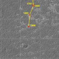
I think it's time to post the "big picture" again. Map updated up to sol 1813.
Route_Map_Sol1813.kml ( 12.91K )
Number of downloads: 498 |
|
|
|
|
|
|
Mar 2 2009, 06:43 PM
Post
#2471
|
|
|
Forum Contributor Group: Members Posts: 1372 Joined: 8-February 04 From: North East Florida, USA. Member No.: 11 |
When o when will we head SE ?
Does anyone know what the offcial route is ? Thanks. |
|
|
|
|
Mar 2 2009, 08:07 PM
Post
#2472
|
|
 Senior Member Group: Members Posts: 2173 Joined: 28-December 04 From: Florida, USA Member No.: 132 |
QUOTE (MahFL @ Mar 2 2009, 01:43 PM)  Does anyone know what the offcial route is ? I guess this is as official as it gets right now. http://www.unmannedspaceflight.com/index.p...st&p=136998 |
|
|
|
|
Mar 2 2009, 10:23 PM
Post
#2473
|
|
|
Member Group: Members Posts: 910 Joined: 4-September 06 From: Boston Member No.: 1102 |
Seems like someone (official or here at UMSF) suggested that Porcupine rim is the next stop?
-------------------- |
|
|
|
|
Mar 3 2009, 01:39 PM
Post
#2474
|
|
|
Forum Contributor Group: Members Posts: 1372 Joined: 8-February 04 From: North East Florida, USA. Member No.: 11 |
Well they must have great faith that Oppy will be able to drive forever...to add all those extra Km to avoid the bigger dunes. I am sure Steve never mentioned this when they first decided to head for Endeavour.

|
|
|
|
|
Mar 5 2009, 06:09 PM
Post
#2475
|
||
|
Senior Member Group: Moderator Posts: 4279 Joined: 19-April 05 From: .br at .es Member No.: 253 |
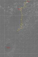
Map update corresponding to sol 1816. We might be reaching the 15km mark in a few (two?) driving sols.
|
|
|
|
|
|
|

|
Lo-Fi Version | Time is now: 19th April 2024 - 01:08 AM |
|
RULES AND GUIDELINES Please read the Forum Rules and Guidelines before posting. IMAGE COPYRIGHT |
OPINIONS AND MODERATION Opinions expressed on UnmannedSpaceflight.com are those of the individual posters and do not necessarily reflect the opinions of UnmannedSpaceflight.com or The Planetary Society. The all-volunteer UnmannedSpaceflight.com moderation team is wholly independent of The Planetary Society. The Planetary Society has no influence over decisions made by the UnmannedSpaceflight.com moderators. |
SUPPORT THE FORUM Unmannedspaceflight.com is funded by the Planetary Society. Please consider supporting our work and many other projects by donating to the Society or becoming a member. |
|