Opportunity Route Map |

  |
Opportunity Route Map |
 Jun 18 2010, 02:53 PM Jun 18 2010, 02:53 PM
Post
#2746
|
|
|
Senior Member  Group: Members Posts: 3516 Joined: 4-November 05 From: North Wales Member No.: 542 |
Is this what you're looking for?
http://www.unmannedspaceflight.com/index.p...ost&p=68584 |
 |
 
|
|
Jun 18 2010, 04:59 PM
Post
#2747
|
|
|
Senior Member Group: Moderator Posts: 4279 Joined: 19-April 05 From: .br at .es Member No.: 253 |
QUOTE (Robert S @ Jun 18 2010, 03:49 PM)  Is it possible to get one update that ONLY covers the days from landing -> Victoria Crater? No, for the time being. I started mapping Opportunity's trek a short time before reaching Erebus and that was on a different background picture until we reached VC. It would take a significant time to re-map those positions to my current baseline map. And the effort to plot the positions from Eagle to Erebus would be also big. QUOTE (ngunn @ Jun 18 2010, 04:53 PM) Is this what you're looking for? http://www.unmannedspaceflight.com/index.p...ost&p=68584 Ahh, those good old times... :-) |
|
|
|
|
Jun 18 2010, 05:21 PM
Post
#2748
|
|
|
Solar System Cartographer Group: Members Posts: 10153 Joined: 5-April 05 From: Canada Member No.: 227 |
"Is it possible... ?"
Robert, what you are looking for can be found here: http://marsrovers.jpl.nasa.gov/mission/tm-...tunity-all.html Some of these maps are local, some cover the whole route. There will be others among the MER press release images if you explore. Phil -------------------- ... because the Solar System ain't gonna map itself.
Also to be found posting similar content on https://mastodon.social/@PhilStooke Maps for download (free PD: https://upload.wikimedia.org/wikipedia/comm...Cartography.pdf NOTE: everything created by me which I post on UMSF is considered to be in the public domain (NOT CC, public domain) |
|
|
|
|
Jun 18 2010, 09:12 PM
Post
#2749
|
|
|
Member Group: Members Posts: 194 Joined: 3-January 10 Member No.: 5156 |
QUOTE (Robert S @ Jun 18 2010, 03:49 PM) Is it possible to get one update that ONLY covers the days from landing -> Victoria Crater? Hi Robert! Some more infos about the traverse map: - The whole traverse path in the analysts Notebook: Not up to date: http://an.rsl.wustl.edu/mer/merbrowser/bro...=map&m=MERB - or use from google earth the mars view, there is also the traverse path from beginning (Menu point: Mars gallery Rovers and landers - opportunity - traverse path) (http://www.gearthblog.com/blog/archives/2009/02/google_earth_5_the_new_google_mars.html) Bye, Moreinput -------------------- Need more input ...
|
|
|
|
|
Jun 20 2010, 08:16 AM
Post
#2750
|
||
|
Senior Member Group: Moderator Posts: 4279 Joined: 19-April 05 From: .br at .es Member No.: 253 |
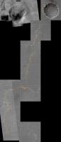
Here's another update, after sol 2276.
Have a look to the 100m grid; the thick vertical line near the right edge corresponds to the "0km" mark starting at Eagle.
 Route_Map_Sol2276.kml ( 50.21K )
Number of downloads: 485
Route_Map_Sol2276.kml ( 50.21K )
Number of downloads: 485 |
|
|
|
|
|
|
Jun 21 2010, 05:29 PM
Post
#2751
|
|
 Martian Photographer Group: Members Posts: 352 Joined: 3-March 05 Member No.: 183 |
And judging from the grid lines, that makes a half-marathon in a new personal and world record of 2275 sols (or 6 years, 4 months back on Earth)--starting the timer at landing on sol 1 rather than at egress.
|
|
|
|
|
Jun 23 2010, 09:42 AM
Post
#2752
|
||
|
Senior Member Group: Moderator Posts: 4279 Joined: 19-April 05 From: .br at .es Member No.: 253 |
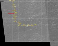
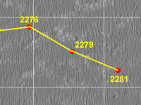
Here's yet another "plot" to the route map, after this last drive which happened during sol 2279.
Since the start of the east drive, the route plot was quickly reaching the right end of the background map to it was time to add another 1km x 1km square to the map. This map was already really big and unfortunately it became too big to manage it as a single picture on my PC so it's time to move on a new image. I'm posting here again the whole route map from Victoria up to date since it will probably be the last update of this picture.
|
|
|
|
|
|
|
Jun 23 2010, 09:44 AM
Post
#2753
|
||
|
Senior Member Group: Moderator Posts: 4279 Joined: 19-April 05 From: .br at .es Member No.: 253 |
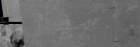
Now, moving on to the new map, this picture will cover the whole "east drive" until reaching Santa Maria (mini-Endurance). I thought it would be better to have the whole background until that waypoint right now instead of adding those 1km squares when needed, because it is important to have the (intermediate) destination on sight. It was my initial intention to cover the whole route up to Endeavour but, again, too much to this laptop; that last section will have to be done on a third picture in the future.
Edit: updated the grid's transparency. This post has been edited by Tesheiner: Jun 24 2010, 08:24 AM |
|
|
|
|
|
|
Jun 23 2010, 10:35 AM
Post
#2754
|
|
 Senior Member Group: Moderator Posts: 2262 Joined: 9-February 04 From: Melbourne - Oz Member No.: 16 |
Wow, scrolling back along the route from Victoria is amazing both from the point of view of what Oppy has accomplished and the amount of work you've put into mapping all the hundreds of sites (knowing how much work goes into each one from the few times I've tried to fill in) Astonishing work Eduardo.
 Great to see Santa Maria on the map - looks like some interesting terrain coming up as we head out into the 'parking lot'. One suggestion: Could you make your grid lines a similar shade of gray as in the previous version? The white lines distract a little too much from the terrain underneath for my eye. -------------------- |
|
|
|
|
Jun 23 2010, 07:14 PM
Post
#2755
|
|
|
Senior Member Group: Moderator Posts: 4279 Joined: 19-April 05 From: .br at .es Member No.: 253 |
QUOTE (jamescanvin @ Jun 23 2010, 12:35 PM) One suggestion: Could you make your grid lines a similar shade of gray as in the previous version? The white lines distract a little too much from the terrain underneath for my eye. Oh, thanks for pointing that. The grid should have had a sort of transparency which I just forgot to set. |
|
|
|
|
Jun 24 2010, 08:27 AM
Post
#2756
|
|
|
Senior Member Group: Moderator Posts: 4279 Joined: 19-April 05 From: .br at .es Member No.: 253 |
Done. I've updated the picture in my previous post.
|
|
|
|
|
Jun 25 2010, 06:39 AM
Post
#2757
|
|
|
Senior Member Group: Moderator Posts: 4279 Joined: 19-April 05 From: .br at .es Member No.: 253 |
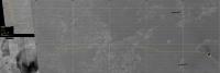
Here's another point at the map; sol 2281.
 Route_Map_Sol2281.kml ( 50.61K )
Number of downloads: 463
Route_Map_Sol2281.kml ( 50.61K )
Number of downloads: 463 |
|
|
|
|
Jun 26 2010, 10:23 AM
Post
#2758
|
||
|
Junior Member Group: Members Posts: 44 Joined: 25-February 08 From: Greece, Komotini Member No.: 4055 |
Hi to everybody! I was looking at Tesheiner`s map and I thought of a possible (the easiest and safest) route for Oppy. What do you say, could that be the one MER team will actually use? Tell me, which do you think would be the best route Oppy should take...
 
Attached thumbnail(s)
-------------------- "It`s one small step for a man. A giant leap for all mankind!" Armstrong, Apollo 11, 1969.
|
|
|
|
|
|
|
Jun 26 2010, 12:41 PM
Post
#2759
|
|
 Senior Member Group: Admin Posts: 3108 Joined: 21-December 05 From: Canberra, Australia Member No.: 615 |
While it can be fun to speculate, the one truism related to the Mars Rovers is that you can never try to guess which will be the 'safest and easiest' route by just looking at the orbital images. The ground beneath the Rovers wheels is the only truth and each drive is full of hidden and potentially fatal dangers.
|
|
|
|
|
Jun 26 2010, 11:17 PM
Post
#2760
|
|
|
Member Group: Members Posts: 910 Joined: 4-September 06 From: Boston Member No.: 1102 |
Also, this thread is for the official map--discussion should go in a different or new thread. Since Tesheiner's big map is almost 500 KB, I'm not sure UMSF wants a thread with 20 modified versions = 10 MB. Maybe we can see how close Ipparchus guessed and leave it as an experiment of one.
-------------------- |
|
|
|
|

|
Lo-Fi Version | Time is now: 28th April 2024 - 02:25 AM |
|
RULES AND GUIDELINES Please read the Forum Rules and Guidelines before posting. IMAGE COPYRIGHT |
OPINIONS AND MODERATION Opinions expressed on UnmannedSpaceflight.com are those of the individual posters and do not necessarily reflect the opinions of UnmannedSpaceflight.com or The Planetary Society. The all-volunteer UnmannedSpaceflight.com moderation team is wholly independent of The Planetary Society. The Planetary Society has no influence over decisions made by the UnmannedSpaceflight.com moderators. |
SUPPORT THE FORUM Unmannedspaceflight.com is funded by the Planetary Society. Please consider supporting our work and many other projects by donating to the Society or becoming a member. |
|