Opportunity Route Map |

  |
Opportunity Route Map |
 Jun 27 2010, 02:20 AM Jun 27 2010, 02:20 AM
Post
#2761
|
|
|
Junior Member  Group: Members Posts: 41 Joined: 18-September 09 Member No.: 4946 |
Thank you all for your answers!!! I really appreciate all the great work you all are doing.
And what makes me even more happy is that you always answer to questions and care! Have a nice day everybody!  Greetings // Robert |
 |
 
|
|
Jun 27 2010, 07:30 AM
Post
#2762
|
|
|
Senior Member Group: Moderator Posts: 4279 Joined: 19-April 05 From: .br at .es Member No.: 253 |
|
|
|
|
|
Jun 27 2010, 07:38 AM
Post
#2763
|
|
 The Poet Dude Group: Moderator Posts: 5551 Joined: 15-March 04 From: Kendal, Cumbria, UK Member No.: 60 |
Aw heck, she's changed her mind about the whole Endeavour thing and is going back to Victoria...

-------------------- |
|
|
|
|
Jun 27 2010, 08:01 AM
Post
#2764
|
|
|
Merciless Robot Group: Admin Posts: 8783 Joined: 8-December 05 From: Los Angeles Member No.: 602 |
Hmm. Dune avoidance maneuver? Must've seen something they didn't like ahead...doesn't look as if they saw anything they did like in that new direction.
Oh, and Stu: Belated thanks for your last 3D!
-------------------- A few will take this knowledge and use this power of a dream realized as a force for change, an impetus for further discovery to make less ancient dreams real.
|
|
|
|
|
Jun 27 2010, 08:09 AM
Post
#2765
|
|
|
The Poet Dude Group: Moderator Posts: 5551 Joined: 15-March 04 From: Kendal, Cumbria, UK Member No.: 60 |
You're more than welcome
Hmm, looks like a nice "corridor" to the north a bit...? http://twitpic.com/20dqtv -------------------- |
|
|
|
|
Jun 27 2010, 09:15 AM
Post
#2766
|
|
 Member Group: Members Posts: 547 Joined: 1-May 06 From: Scotland (Ecosse, Escocia) Member No.: 759 |
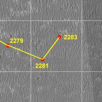
yes, the last 2 maneuvres, SE to 2281 and NE to 2283 just look like a dune-avoidance zig-zag to get around the larger dunes north of the 2281 postion. The general trend from 2279 to 2283 is due East.
|
|
|
|
|
Jun 30 2010, 06:50 AM
Post
#2767
|
|
|
Senior Member Group: Moderator Posts: 4279 Joined: 19-April 05 From: .br at .es Member No.: 253 |
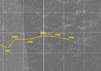
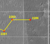
The East trend is reinforced by today's 70m drive. Here's a map crop with the latest plot corresponding to sol 2286.
  Route_Map_Sol2286.kml ( 51.17K )
Number of downloads: 665
Route_Map_Sol2286.kml ( 51.17K )
Number of downloads: 665 |
|
|
|
|
Jul 8 2010, 05:50 PM
Post
#2768
|
|
|
Member Group: Members Posts: 128 Joined: 28-October 08 From: Boston, MA Member No.: 4469 |
While Eduardo is otherwise occupied with life's myriad demands, there is a Tim Parker map update on the MER site to tie us over. Another 2 drives, another 140 meters of solid progress to the east. These drives were made on sols 2288 and 2293.
|
|
|
|
|
Jul 8 2010, 10:23 PM
Post
#2769
|
|
|
Junior Member Group: Members Posts: 71 Joined: 19-January 10 From: Grimsby, N.E. Lincs, UK Member No.: 5179 |
QUOTE (Poolio @ Jul 8 2010, 06:50 PM)  Another 2 drives, another 140 meters of solid progress to the east. Is the 70m per driving sol limited by the energy currently available, or are they held back by other factors (wheel current etc). I guess what I'm asking is will we see the drives lengthen in the weeks to come or will 70m continue to be the norm? Neil |
|
|
|
|
Jul 8 2010, 11:04 PM
Post
#2770
|
|
 Senior Member Group: Members Posts: 4246 Joined: 17-January 05 Member No.: 152 |
They've found that 70m backwards keeps the RF wheel current at bay on the current terrain. Who knows, maybe things will change on the flatter terrain and more extensive bedrock ahead. (This is not a route map question, btw.)
|
|
|
|
|
Jul 10 2010, 09:31 AM
Post
#2771
|
||
|
Senior Member Group: Moderator Posts: 4279 Joined: 19-April 05 From: .br at .es Member No.: 253 |
QUOTE (Poolio @ Jul 8 2010, 07:50 PM) While Eduardo is otherwise occupied with life's myriad demands, ... ... like summer vacations, for instance!  I stole some time to do a quick update of my route map covering up to sol 2295, and here it is. I would call it a "blind" update since it is only based on the data reported by the rover itself and is not corrected i.e. registered with the help of navcam mosaics; that would be the best but takes too much time in the current circumstances.
Route_Map_Sol2295.kml ( 51.76K )
Number of downloads: 458 |
|
|
|
|
|
|
Jul 10 2010, 09:45 AM
Post
#2772
|
|
|
The Poet Dude Group: Moderator Posts: 5551 Joined: 15-March 04 From: Kendal, Cumbria, UK Member No.: 60 |
Ah, always a relief when normal service is resumed...
Good to have you and the fantastic updates back.Talking about resumption of "normal service"... last I heard from the webmaster of the Exploratorium site was that he was hoping to have everything back up and running again "within the week", after bringing in JPL to help with some issues. That was a week ago. So maybe we'll be able to follow things on Exploratorium again soon. -------------------- |
|
|
|
|
Jul 10 2010, 11:42 AM
Post
#2773
|
|
|
Senior Member Group: Members Posts: 3516 Joined: 4-November 05 From: North Wales Member No.: 542 |
Great news. I was just about to suggest we organise a whip-round for a new hard drive.
Will the jump back to near real time produce a striking step change in the vista, I wonder? |
|
|
|
|
Jul 10 2010, 02:19 PM
Post
#2774
|
|
 Senior Member Group: Members Posts: 2492 Joined: 15-January 05 From: center Italy Member No.: 150 |
Welcome back, Eduardo!
Based on your last map, average straight shift was 15.5 m/sol in last 50 sols. Extrapolating it, it will take 290 sols to Santa Maria crater and (ehm) 666 sols to cape Tribulation... this corresponds to May 2012, if I didn't make errors. -------------------- I always think before posting! - Marco -
|
|
|
|
|
Jul 10 2010, 05:55 PM
Post
#2775
|
|
|
Member Group: Members Posts: 910 Joined: 4-September 06 From: Boston Member No.: 1102 |
Eduardo, thank you for all you do. I'm wondering if you could add two lines of links at the bottom of your posts back to summary posts and maps:
. Post #2752 ____ Last update of trip from Victoria to Endeavor ____ Map Post #2753 ____ Current map of drive to Santa Maria ____ Map -------------------- |
|
|
|
|

|
Lo-Fi Version | Time is now: 27th April 2024 - 03:18 AM |
|
RULES AND GUIDELINES Please read the Forum Rules and Guidelines before posting. IMAGE COPYRIGHT |
OPINIONS AND MODERATION Opinions expressed on UnmannedSpaceflight.com are those of the individual posters and do not necessarily reflect the opinions of UnmannedSpaceflight.com or The Planetary Society. The all-volunteer UnmannedSpaceflight.com moderation team is wholly independent of The Planetary Society. The Planetary Society has no influence over decisions made by the UnmannedSpaceflight.com moderators. |
SUPPORT THE FORUM Unmannedspaceflight.com is funded by the Planetary Society. Please consider supporting our work and many other projects by donating to the Society or becoming a member. |
|