Opportunity Route Map |

  |
Opportunity Route Map |
 Mar 26 2013, 12:54 PM Mar 26 2013, 12:54 PM
Post
#3181
|
||
|
Senior Member  Group: Moderator Posts: 4279 Joined: 19-April 05 From: .br at .es Member No.: 253 |
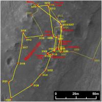
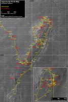
Here's another map update, probably the last one at "Benny Hill".
The current position (sol 3257) is virtually the same as during sols 3233-3240.
 Route_Map_Sol3257.kmz ( 22.91K )
Number of downloads: 404
Route_Map_Sol3257.kmz ( 22.91K )
Number of downloads: 404 |
|
 |
 
|
|
|
Mar 27 2013, 06:44 AM
Post
#3182
|
|
 Senior Member Group: Members Posts: 1084 Joined: 19-February 05 From: Close to Meudon Observatory in France Member No.: 172 |
Going back and forth with Opportunity : I think they are on the verge of making/announcing big discoveries that will compete with those made with Curiosity

|
|
|
|
|
May 16 2013, 08:18 PM
Post
#3183
|
||
|
Senior Member Group: Moderator Posts: 4279 Joined: 19-April 05 From: .br at .es Member No.: 253 |
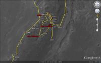
I had no time to do a proper update of the route map so here's just a snapshot from the KML version on Google Earth/Mars.
Seems that she will be leaving Cape York quite soon.
Route_Map_Sol3309.kmz ( 23.06K )
Number of downloads: 337 |
|
|
|
|
|
|
May 17 2013, 02:26 PM
Post
#3184
|
|
|
Senior Member Group: Moderator Posts: 4279 Joined: 19-April 05 From: .br at .es Member No.: 253 |
|
|
|
|
|
May 19 2013, 07:00 PM
Post
#3185
|
|
|
Senior Member Group: Moderator Posts: 4279 Joined: 19-April 05 From: .br at .es Member No.: 253 |
|
|
|
|
|
May 21 2013, 08:06 PM
Post
#3186
|
||
|
Senior Member Group: Moderator Posts: 4279 Joined: 19-April 05 From: .br at .es Member No.: 253 |
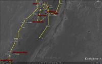
Updated after sol 3314, including a pin at the 36km mark.
Route_Map_Sol3314.kmz ( 23.2K )
Number of downloads: 373 |
|
|
|
|
|
|
May 23 2013, 08:10 PM
Post
#3187
|
||
|
Senior Member Group: Moderator Posts: 4279 Joined: 19-April 05 From: .br at .es Member No.: 253 |
Here's another update, now up to sol 3316 and revising / adjusting some of the previous positions.
Route_Map_Sol3316.kmz ( 23.27K )
Number of downloads: 328 |
|
|
|
|
|
|
May 23 2013, 08:47 PM
Post
#3188
|
||
 Senior Member Group: Moderator Posts: 3431 Joined: 11-August 04 From: USA Member No.: 98 |
Nice work, as always.
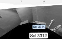
This is minor, but there was a jog to the W-NW from the sol 3312 position to image tiny "Duyfken Crater" before continuing south. The metadata was updated some time after the drive, and we still don't have the images, so it's a little obscure.
Attached thumbnail(s)
|
|
|
|
|
|
|
May 23 2013, 09:50 PM
Post
#3189
|
|
|
Senior Member Group: Moderator Posts: 4279 Joined: 19-April 05 From: .br at .es Member No.: 253 |
Thanks Mike. I will take that into account on the next map update.
I was a little bit puzzled by that imaging sequence ("Duyfken Crater") because it was too wide (3x1) and pointing nowhere (basically N). I thought it was taken before starting moving on that sol 3314 but now I realize it was a mid-drive imaging. All's clear. |
|
|
|
|
May 24 2013, 09:16 PM
Post
#3190
|
||
|
Senior Member Group: Moderator Posts: 4279 Joined: 19-April 05 From: .br at .es Member No.: 253 |
There was another drive today; four days in a row! Here's the updated map.
Route_Map_Sol3317.kmz ( 23.37K )
Number of downloads: 397 |
|
|
|
|
|
|
May 25 2013, 08:05 AM
Post
#3191
|
|
|
Senior Member Group: Members Posts: 2920 Joined: 14-February 06 From: Very close to the Pyrénées Mountains (France) Member No.: 682 |
We can see on the map that since arrival at Spirit point on sol 2681, the increased net distance from landing has been a mere +150m South in nearly a martian year! (636 sols instead of 686). We're about to improve this a lot in those 50 sols difference

-------------------- |
|
|
|
|
May 25 2013, 01:39 PM
Post
#3192
|
|
 Senior Member Group: Members Posts: 2492 Joined: 15-January 05 From: center Italy Member No.: 150 |
I am so happy for this achievement, after months of (apparently) unuseful loops!
 Go Oppy!  -------------------- I always think before posting! - Marco -
|
|
|
|
|
May 31 2013, 10:29 PM
Post
#3193
|
||
|
Senior Member Group: Moderator Posts: 4279 Joined: 19-April 05 From: .br at .es Member No.: 253 |
And yet another update to the route map, adjusting several past positions (starting on sol 3315) and adding the missing ones up to thisol 3324.
Route_Map_Sol3324.kmz ( 23.48K )
Number of downloads: 396 |
|
|
|
|
|
|
Jun 7 2013, 10:12 PM
Post
#3194
|
||
|
Senior Member Group: Moderator Posts: 4279 Joined: 19-April 05 From: .br at .es Member No.: 253 |
I was in a business travel the whole week and couldn't update the route map in the meantime. But now, here's a fresh one and updated up to sol 3330.
Route_Map_Sol3330.kmz ( 23.62K )
Number of downloads: 365 |
|
|
|
|
|
|
Jun 10 2013, 06:55 PM
Post
#3195
|
||
|
Senior Member Group: Moderator Posts: 4279 Joined: 19-April 05 From: .br at .es Member No.: 253 |
I took some time to extend the map up to our expected destination Solander Point. Here is it, updated with the data from the latest drive on sol 3333 and correcting a few of the previous plots. From now I will usually post just a crop of it, including the whole picture just from time to time.
Route_Map_Sol3333.kmz ( 23.67K )
Number of downloads: 346 |
|
|
|
|
|
|

|
Lo-Fi Version | Time is now: 25th April 2024 - 08:27 PM |
|
RULES AND GUIDELINES Please read the Forum Rules and Guidelines before posting. IMAGE COPYRIGHT |
OPINIONS AND MODERATION Opinions expressed on UnmannedSpaceflight.com are those of the individual posters and do not necessarily reflect the opinions of UnmannedSpaceflight.com or The Planetary Society. The all-volunteer UnmannedSpaceflight.com moderation team is wholly independent of The Planetary Society. The Planetary Society has no influence over decisions made by the UnmannedSpaceflight.com moderators. |
SUPPORT THE FORUM Unmannedspaceflight.com is funded by the Planetary Society. Please consider supporting our work and many other projects by donating to the Society or becoming a member. |
|