MSL Route Map |

  |
MSL Route Map |
 Oct 8 2013, 08:42 PM Oct 8 2013, 08:42 PM
Post
#271
|
||
|
Solar System Cartographer  Group: Members Posts: 10149 Joined: 5-April 05 From: Canada Member No.: 227 |
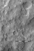
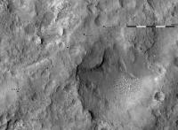
We just had a drive on sol 417. To the east (EDIT: I mean west. WEST - thanks, MahFL, for correcting me!) about 60 m. The route is mostly guesswork so far.
Phil
-------------------- ... because the Solar System ain't gonna map itself.
Also to be found posting similar content on https://mastodon.social/@PhilStooke NOTE: everything created by me which I post on UMSF is considered to be in the public domain (NOT CC, public domain) |
|
 |
 
|
|
|
Oct 11 2013, 02:00 PM
Post
#272
|
||
|
Solar System Cartographer Group: Members Posts: 10149 Joined: 5-April 05 From: Canada Member No.: 227 |
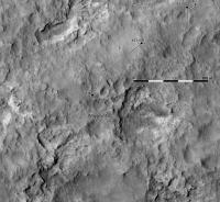
Map update to sol 419. I've extended the base to include the approximate location of Waypoint 2 at bottom left. As the relief gets more extreme I have also switched the base to an ortho image.
Phil
-------------------- ... because the Solar System ain't gonna map itself.
Also to be found posting similar content on https://mastodon.social/@PhilStooke NOTE: everything created by me which I post on UMSF is considered to be in the public domain (NOT CC, public domain) |
|
|
|
|
|
|
Oct 15 2013, 12:05 PM
Post
#273
|
||
|
Solar System Cartographer Group: Members Posts: 10149 Joined: 5-April 05 From: Canada Member No.: 227 |
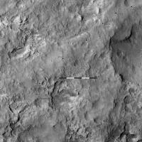
Map updated to sol 422.
Phil
-------------------- ... because the Solar System ain't gonna map itself.
Also to be found posting similar content on https://mastodon.social/@PhilStooke NOTE: everything created by me which I post on UMSF is considered to be in the public domain (NOT CC, public domain) |
|
|
|
|
|
|
Oct 16 2013, 01:56 PM
Post
#274
|
||
|
Solar System Cartographer Group: Members Posts: 10149 Joined: 5-April 05 From: Canada Member No.: 227 |
Another nice drive on sol 424.
Phil
-------------------- ... because the Solar System ain't gonna map itself.
Also to be found posting similar content on https://mastodon.social/@PhilStooke NOTE: everything created by me which I post on UMSF is considered to be in the public domain (NOT CC, public domain) |
|
|
|
|
|
|
Oct 18 2013, 03:05 PM
Post
#275
|
||
|
Solar System Cartographer Group: Members Posts: 10149 Joined: 5-April 05 From: Canada Member No.: 227 |
A shorter drive on sol 426, getting into rougher country now.
Phil
-------------------- ... because the Solar System ain't gonna map itself.
Also to be found posting similar content on https://mastodon.social/@PhilStooke NOTE: everything created by me which I post on UMSF is considered to be in the public domain (NOT CC, public domain) |
|
|
|
|
|
|
Oct 18 2013, 06:36 PM
Post
#276
|
||
|
Solar System Cartographer Group: Members Posts: 10149 Joined: 5-April 05 From: Canada Member No.: 227 |
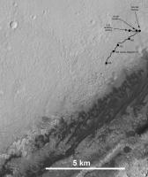
Here's an update to the overview map. We're making progress but still a good long way to go. We are 100 sols out from Glenelg now, and we have about twice as far to go again just to round the corner of the dark dunes and start to head up the hill.
Phil
-------------------- ... because the Solar System ain't gonna map itself.
Also to be found posting similar content on https://mastodon.social/@PhilStooke NOTE: everything created by me which I post on UMSF is considered to be in the public domain (NOT CC, public domain) |
|
|
|
|
|
|
Oct 18 2013, 11:07 PM
Post
#277
|
|
|
Member Group: Members Posts: 105 Joined: 27-August 05 Member No.: 479 |
thanks for all you do Phil!
I have seen many papers from the mars landing site committee meetings over the years but what is the plan for these dunes? I know it will be day to day and caution for to much of automated driving(?) but what do you think the future route might be? I see many areas where the dunes terminate to ground soil so drive around these? and observations of these dunes to.................. 
|
|
|
|
|
Oct 18 2013, 11:47 PM
Post
#278
|
|
 Senior Member Group: Admin Posts: 3108 Joined: 21-December 05 From: Canberra, Australia Member No.: 615 |
> but what do you think the future route might be?
A quick Google and hey presto! MSL proposed route map. Apart from a few small turns, the route at this stage is staying pretty much on the proposed track. It can change of course with small stops and detours for science, but the goal is to get to the Mt Sharp entry point before the end of the nominal mission. |
|
|
|
|
Oct 19 2013, 12:38 AM
Post
#279
|
|
|
Member Group: Members Posts: 105 Joined: 27-August 05 Member No.: 479 |
ADMIN NOTE: Unnecessary quoting removed. Refer UMSF rule 3.5 and recent notification reminder.
thanks! I love the future proposed geologic way points pointed out in green triangles, you would hope that at the proposed "entry point" that the rover might find a safe way to approach one of the "sand dunes" to do some comparative study's of these in crater sand dunes VS MER images of sand dunes. do the wind patterns differ enough at MER and MSL sites to sift the sand particles in any way ?(no?) any geochemistry differences?(yes?) gale is a deep impact site does any of the sand dune material in situ? or blown over the eons from the outside environment? I remember on this site seeing a MRO image of patterns of mars twisters left on the surface but termination in the surrounding hills, I posted a comment in regards to air pressure questions. I by the way see further wind blown deposits in front of the proposed entry point............................... 
|
|
|
|
|
Oct 21 2013, 02:01 PM
Post
#280
|
||
|
Solar System Cartographer Group: Members Posts: 10149 Joined: 5-April 05 From: Canada Member No.: 227 |
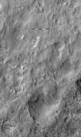
Sol 429 drive - just a short one. I may have to adjust the position when I get more navcams. EDIT - map replaced with corrected version
Phil
-------------------- ... because the Solar System ain't gonna map itself.
Also to be found posting similar content on https://mastodon.social/@PhilStooke NOTE: everything created by me which I post on UMSF is considered to be in the public domain (NOT CC, public domain) |
|
|
|
|
|
|
Oct 23 2013, 01:27 PM
Post
#281
|
||
|
Solar System Cartographer Group: Members Posts: 10149 Joined: 5-April 05 From: Canada Member No.: 227 |
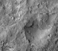
This is the position after the sol 431 drive.
Phil
-------------------- ... because the Solar System ain't gonna map itself.
Also to be found posting similar content on https://mastodon.social/@PhilStooke NOTE: everything created by me which I post on UMSF is considered to be in the public domain (NOT CC, public domain) |
|
|
|
|
|
|
Oct 25 2013, 01:51 PM
Post
#282
|
||
|
Solar System Cartographer Group: Members Posts: 10149 Joined: 5-April 05 From: Canada Member No.: 227 |
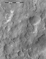
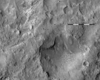
I've updated the map for the sol 433 drive - a firm location here. We will probably be here over the weekend. Not sure where the exact location of Waypoint 2 will be in this area.
Phil Stooke
-------------------- ... because the Solar System ain't gonna map itself.
Also to be found posting similar content on https://mastodon.social/@PhilStooke NOTE: everything created by me which I post on UMSF is considered to be in the public domain (NOT CC, public domain) |
|
|
|
|
|
|
Oct 28 2013, 05:10 PM
Post
#283
|
||
|
Solar System Cartographer Group: Members Posts: 10149 Joined: 5-April 05 From: Canada Member No.: 227 |
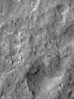
I only have a rough position for sol 436 right now, but this must be close. This drive should have pushed past 4 km total distance.
Phil
-------------------- ... because the Solar System ain't gonna map itself.
Also to be found posting similar content on https://mastodon.social/@PhilStooke NOTE: everything created by me which I post on UMSF is considered to be in the public domain (NOT CC, public domain) |
|
|
|
|
|
|
Oct 29 2013, 02:17 PM
Post
#284
|
||
|
Solar System Cartographer Group: Members Posts: 10149 Joined: 5-April 05 From: Canada Member No.: 227 |
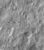
We must be out of restricted sols now. Another drive - there's some interesting stratigraphy emerging here.
Phil
-------------------- ... because the Solar System ain't gonna map itself.
Also to be found posting similar content on https://mastodon.social/@PhilStooke NOTE: everything created by me which I post on UMSF is considered to be in the public domain (NOT CC, public domain) |
|
|
|
|
|
|
Oct 29 2013, 03:19 PM
Post
#285
|
|
|
Founder Group: Chairman Posts: 14431 Joined: 8-February 04 Member No.: 1 |
QUOTE (Phil Stooke @ Oct 29 2013, 07:17 AM)  We must be out of restricted sols now. That drive was autonav only - it was sol 2 of a 2 sol driving plan. All it got was a go-no go without a full up planning cycle |
|
|
|
|

|
Lo-Fi Version | Time is now: 23rd April 2024 - 04:03 PM |
|
RULES AND GUIDELINES Please read the Forum Rules and Guidelines before posting. IMAGE COPYRIGHT |
OPINIONS AND MODERATION Opinions expressed on UnmannedSpaceflight.com are those of the individual posters and do not necessarily reflect the opinions of UnmannedSpaceflight.com or The Planetary Society. The all-volunteer UnmannedSpaceflight.com moderation team is wholly independent of The Planetary Society. The Planetary Society has no influence over decisions made by the UnmannedSpaceflight.com moderators. |
SUPPORT THE FORUM Unmannedspaceflight.com is funded by the Planetary Society. Please consider supporting our work and many other projects by donating to the Society or becoming a member. |
|