MSL Route Map |

  |
MSL Route Map |
 Oct 29 2013, 05:53 PM Oct 29 2013, 05:53 PM
Post
#286
|
||
 Member  Group: Members Posts: 219 Joined: 14-November 11 From: Washington, DC Member No.: 6237 |
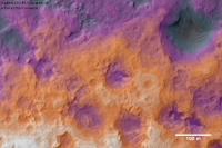
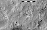
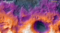
Here is a quick, very local contour map I made to help me visualize the area near WP2. I didn't do much more than crop & apply a 16-color map to the the DEM, overlaid on the corresponding orthophoto, so I'm not making a claim to any particular accuracy, but it seems to work well.
The contour levels should be about 1.1 m each; the highest (white) should be at about -4495 m according to the DEM. |
|
 |
 
|
|
|
Oct 29 2013, 06:47 PM
Post
#287
|
||
|
Solar System Cartographer Group: Members Posts: 10151 Joined: 5-April 05 From: Canada Member No.: 227 |
That looks good! I took the liberty of merging it with my map to see what it would look like.
Phil
-------------------- ... because the Solar System ain't gonna map itself.
Also to be found posting similar content on https://mastodon.social/@PhilStooke Maps for download (free PD: https://upload.wikimedia.org/wikipedia/comm...Cartography.pdf NOTE: everything created by me which I post on UMSF is considered to be in the public domain (NOT CC, public domain) |
|
|
|
|
|
|
Oct 30 2013, 09:47 AM
Post
#288
|
||
|
Junior Member Group: Members Posts: 59 Joined: 18-July 07 From: London, UK Member No.: 2873 |
Did somebody say DEM?!
Phil, I added some contours to your route map, and thought I'd try a different colour stretch than Greenish for the DEM, to see how it looks (a lot worse than it actually is).
|
|
|
|
|
|
|
Oct 30 2013, 02:11 PM
Post
#289
|
||
|
Solar System Cartographer Group: Members Posts: 10151 Joined: 5-April 05 From: Canada Member No.: 227 |
That's great. I prefer your colours generally, but Greenish's were more appropriate for Halloween (sorry, Greenish!)
Anyway, back to monochrome. Yet another drive - I'm assuming a straight route until I know more, and the exact location may need revising.
Phil -------------------- ... because the Solar System ain't gonna map itself.
Also to be found posting similar content on https://mastodon.social/@PhilStooke Maps for download (free PD: https://upload.wikimedia.org/wikipedia/comm...Cartography.pdf NOTE: everything created by me which I post on UMSF is considered to be in the public domain (NOT CC, public domain) |
|
|
|
|
|
|
Oct 30 2013, 02:15 PM
Post
#290
|
|
|
Member Group: Members Posts: 219 Joined: 14-November 11 From: Washington, DC Member No.: 6237 |
Phil and pgrindod, very cool - I had been getting
|
|
|
|
|
Oct 31 2013, 01:41 PM
Post
#291
|
||
|
Solar System Cartographer Group: Members Posts: 10151 Joined: 5-April 05 From: Canada Member No.: 227 |
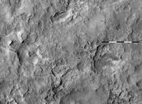
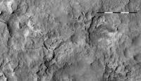
Sol 439 - right there.
Phil
-------------------- ... because the Solar System ain't gonna map itself.
Also to be found posting similar content on https://mastodon.social/@PhilStooke Maps for download (free PD: https://upload.wikimedia.org/wikipedia/comm...Cartography.pdf NOTE: everything created by me which I post on UMSF is considered to be in the public domain (NOT CC, public domain) |
|
|
|
|
|
|
Nov 4 2013, 03:16 PM
Post
#292
|
||
|
Solar System Cartographer Group: Members Posts: 10151 Joined: 5-April 05 From: Canada Member No.: 227 |
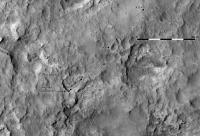
Even more right there!
Phil
-------------------- ... because the Solar System ain't gonna map itself.
Also to be found posting similar content on https://mastodon.social/@PhilStooke Maps for download (free PD: https://upload.wikimedia.org/wikipedia/comm...Cartography.pdf NOTE: everything created by me which I post on UMSF is considered to be in the public domain (NOT CC, public domain) |
|
|
|
|
|
|
Nov 14 2013, 09:30 PM
Post
#293
|
||
|
Solar System Cartographer Group: Members Posts: 10151 Joined: 5-April 05 From: Canada Member No.: 227 |
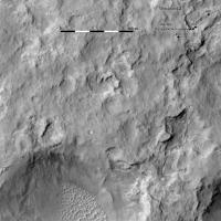
On the road again - a bit of maneuvering to get up on the top of Cooperstown.
Waypoint 3 is not far ahead but from the sound of things it will be skipped. Waypoint 4 is as far ahead as Yellowknife Bay is behind us, but it's a really cool place to look forward to. Phil
-------------------- ... because the Solar System ain't gonna map itself.
Also to be found posting similar content on https://mastodon.social/@PhilStooke Maps for download (free PD: https://upload.wikimedia.org/wikipedia/comm...Cartography.pdf NOTE: everything created by me which I post on UMSF is considered to be in the public domain (NOT CC, public domain) |
|
|
|
|
|
|
Nov 15 2013, 06:21 PM
Post
#294
|
||
|
Solar System Cartographer Group: Members Posts: 10151 Joined: 5-April 05 From: Canada Member No.: 227 |
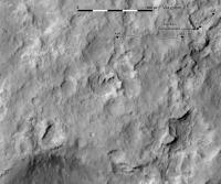
Here's the sol 454 drive. The location should be good but the route is conjectural until I have more data.
Phil
-------------------- ... because the Solar System ain't gonna map itself.
Also to be found posting similar content on https://mastodon.social/@PhilStooke Maps for download (free PD: https://upload.wikimedia.org/wikipedia/comm...Cartography.pdf NOTE: everything created by me which I post on UMSF is considered to be in the public domain (NOT CC, public domain) |
|
|
|
|
|
|
Nov 17 2013, 10:29 AM
Post
#295
|
||
 Senior Member Group: Members Posts: 2492 Joined: 15-January 05 From: center Italy Member No.: 150 |
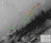
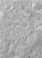
I made a comparison between the planned "Rapid Transit Route" published almost 3 months ago and effective route map until to now:
The team followed quite closely the planned route and now we are already half-way between way-points 2 and 3! Just for fun, I tried to extrapolate future milestones based on the average velocity between WP-1 and WP-2 and assuming an average stop of a dozen sols in each WP: Sol 461-473 : WP-3 Sol 513-525 : WP-4 Sol 620-632 : WP-5 Sol 705 : Entry Point Obviously, these dates are extremely hypothetical and assumed speed is quite conservative... they could change if major issues or speed changes or even surprises will occur in next months! -------------------- I always think before posting! - Marco -
|
|
|
|
|
|
|
Nov 18 2013, 02:24 PM
Post
#296
|
||
|
Solar System Cartographer Group: Members Posts: 10151 Joined: 5-April 05 From: Canada Member No.: 227 |
Update to sol 456. The location should be good, but the last drive path is just a guess until I get more information.
Phil
-------------------- ... because the Solar System ain't gonna map itself.
Also to be found posting similar content on https://mastodon.social/@PhilStooke Maps for download (free PD: https://upload.wikimedia.org/wikipedia/comm...Cartography.pdf NOTE: everything created by me which I post on UMSF is considered to be in the public domain (NOT CC, public domain) |
|
|
|
|
|
|
Nov 27 2013, 02:20 PM
Post
#297
|
||
|
Solar System Cartographer Group: Members Posts: 10151 Joined: 5-April 05 From: Canada Member No.: 227 |
Another map update after the very welcome drive on sol 465. I may update the new location when I get more information. (EDIT: it's been edited to fix earlier route)
Phil
-------------------- ... because the Solar System ain't gonna map itself.
Also to be found posting similar content on https://mastodon.social/@PhilStooke Maps for download (free PD: https://upload.wikimedia.org/wikipedia/comm...Cartography.pdf NOTE: everything created by me which I post on UMSF is considered to be in the public domain (NOT CC, public domain) |
|
|
|
|
|
|
Dec 2 2013, 02:36 PM
Post
#298
|
||
|
Solar System Cartographer Group: Members Posts: 10151 Joined: 5-April 05 From: Canada Member No.: 227 |
The sol 470 map - terrain is getting quite rugged.
Phil
-------------------- ... because the Solar System ain't gonna map itself.
Also to be found posting similar content on https://mastodon.social/@PhilStooke Maps for download (free PD: https://upload.wikimedia.org/wikipedia/comm...Cartography.pdf NOTE: everything created by me which I post on UMSF is considered to be in the public domain (NOT CC, public domain) |
|
|
|
|
|
|
Dec 2 2013, 05:03 PM
Post
#299
|
|||
|
Member Group: Members Posts: 219 Joined: 14-November 11 From: Washington, DC Member No.: 6237 |
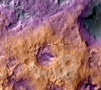
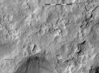
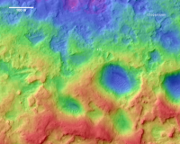
A basic color contour overlay of the nearby area, again cropped so I could use 16 levels of 1m each.
EDIT: and a similar map for a somewhat larger area, along the proposed route. In a more typical (if less color-blind friendly) "rainbow" color scheme, since it's no longer Halloween. Here, the 32 levels are about 0.7m each.
|
||
|
|
|
||
|
Dec 3 2013, 06:06 PM
Post
#300
|
|||||
|
Solar System Cartographer Group: Members Posts: 10151 Joined: 5-April 05 From: Canada Member No.: 227 |
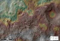
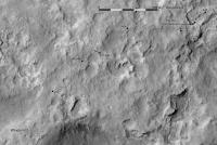
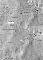
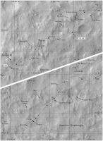
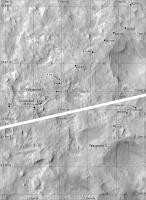
Here is a mid-resolution overview of the route (reduced from but formatted for my book). I could use a few new feature names. Anyone? Is this thing on?
The white squares are places where the arm instruments were used on the surface - imaging and ChemCam were done most places. These still need to be updated in Yellowknife Bay so that area is not complete yet. More names will come from the PDS release on the 13th, but only up to sol 360. Phil
-------------------- ... because the Solar System ain't gonna map itself.
Also to be found posting similar content on https://mastodon.social/@PhilStooke Maps for download (free PD: https://upload.wikimedia.org/wikipedia/comm...Cartography.pdf NOTE: everything created by me which I post on UMSF is considered to be in the public domain (NOT CC, public domain) |
||||
|
|
|
||||
|

|
Lo-Fi Version | Time is now: 25th April 2024 - 08:44 AM |
|
RULES AND GUIDELINES Please read the Forum Rules and Guidelines before posting. IMAGE COPYRIGHT |
OPINIONS AND MODERATION Opinions expressed on UnmannedSpaceflight.com are those of the individual posters and do not necessarily reflect the opinions of UnmannedSpaceflight.com or The Planetary Society. The all-volunteer UnmannedSpaceflight.com moderation team is wholly independent of The Planetary Society. The Planetary Society has no influence over decisions made by the UnmannedSpaceflight.com moderators. |
SUPPORT THE FORUM Unmannedspaceflight.com is funded by the Planetary Society. Please consider supporting our work and many other projects by donating to the Society or becoming a member. |
|