MSL Route Map |

  |
MSL Route Map |
 May 17 2015, 03:26 PM May 17 2015, 03:26 PM
Post
#616
|
||
|
Solar System Cartographer  Group: Members Posts: 10158 Joined: 5-April 05 From: Canada Member No.: 227 |
And back we go, for a run around Jock Butte to try that approach. I think it might work if we aim for the northern tip of the Murray Formation outcrop in that area.
Phil
EDIT: Answering Floyd's question below: I'm only guessing, but I was thinking of moving to a place south of Apple on that crop of my map, and then southeast around the drifts here, where it looked to me as if we could reach the light-toned rocks just a bit outside the right edge of this map. I assume they will want to minimize the time it takes to get to the target outcrop. -------------------- ... because the Solar System ain't gonna map itself.
Also to be found posting similar content on https://mastodon.social/@PhilStooke Maps for download (free PD: https://upload.wikimedia.org/wikipedia/comm...Cartography.pdf NOTE: everything created by me which I post on UMSF is considered to be in the public domain (NOT CC, public domain) |
|
 |
 
|
|
|
May 17 2015, 07:26 PM
Post
#617
|
|
|
Member Group: Members Posts: 910 Joined: 4-September 06 From: Boston Member No.: 1102 |
QUOTE (Phil Stooke @ May 9 2015, 09:08 AM)  Here's an update - correcting the drive on sol 976 and adding some names. Oh - and moving West Ridge to the place i now think it should be. Note: to see image go to Phil's post. Tried all ways I could think of to get the link to Phil's image here, but just get HTML and no image.... This is a map that shows a wider view. Phil, are you suggesting we will go east skirting the dunes until south of Daughter of the Sun and then cross the narrowest spot? -------------------- |
|
|
|
|
May 17 2015, 08:51 PM
Post
#618
|
|
|
Senior Member Group: Members Posts: 3516 Joined: 4-November 05 From: North Wales Member No.: 542 |
Trying . .
http://www.unmannedspaceflight.com/index.p...st&p=220161 I also like to see the wider view and would would welcome it being posted more often. |
|
|
|
|
May 17 2015, 11:53 PM
Post
#619
|
|
 Member Group: Members Posts: 894 Joined: 15-June 09 From: Lisbon, Portugal Member No.: 4824 |
Update to Sol 987.
Fernando  MSL_Curiosity_Route_Map_Sol_0987_2015MAY18.kmz ( 249.39K )
Number of downloads: 612
MSL_Curiosity_Route_Map_Sol_0987_2015MAY18.kmz ( 249.39K )
Number of downloads: 612 |
|
|
|
|
May 20 2015, 02:49 PM
Post
#620
|
||
|
Solar System Cartographer Group: Members Posts: 10158 Joined: 5-April 05 From: Canada Member No.: 227 |
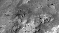
OK, a good drive, as Midnight Planets told us. My guess... from here, south to the west end of Logan Pass and back down it to the east to get to the Mt. Stimson outcrop. Time will tell.
Phil
-------------------- ... because the Solar System ain't gonna map itself.
Also to be found posting similar content on https://mastodon.social/@PhilStooke Maps for download (free PD: https://upload.wikimedia.org/wikipedia/comm...Cartography.pdf NOTE: everything created by me which I post on UMSF is considered to be in the public domain (NOT CC, public domain) |
|
|
|
|
|
|
May 21 2015, 05:54 PM
Post
#621
|
||
|
Solar System Cartographer Group: Members Posts: 10158 Joined: 5-April 05 From: Canada Member No.: 227 |
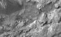
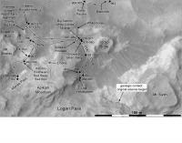
We had an uphill drive on sol 991, and the Navcams may be showing us the contact we are aiming for here.
Phil
-------------------- ... because the Solar System ain't gonna map itself.
Also to be found posting similar content on https://mastodon.social/@PhilStooke Maps for download (free PD: https://upload.wikimedia.org/wikipedia/comm...Cartography.pdf NOTE: everything created by me which I post on UMSF is considered to be in the public domain (NOT CC, public domain) |
|
|
|
|
|
|
May 21 2015, 10:56 PM
Post
#622
|
|
|
Member Group: Members Posts: 894 Joined: 15-June 09 From: Lisbon, Portugal Member No.: 4824 |
Update to Sol 991.
Fernando
MSL_Curiosity_Route_Map_Sol_0991_2015MAY21.kmz ( 249.62K )
Number of downloads: 522 |
|
|
|
|
May 26 2015, 11:52 PM
Post
#623
|
||
|
Solar System Cartographer Group: Members Posts: 10158 Joined: 5-April 05 From: Canada Member No.: 227 |
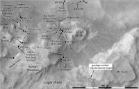
A different view of the route map. If you see a map like this with white squares for the in situ study sites (I mean, places where the arm instruments are used, usually MAHLI and APXS, but also DRT and drill), it's one of my atlas illustrations. Right now I am collecting material for Volume 3 - for completion in 2020, maybe. Volume 2 (Spirit to the end of Curiosity's primary mission) is on the publisher's desk, out at the end of this year.
I'm using this because it is enlarged a bit from my standard route map, so I can fit in more feature names. Phil
-------------------- ... because the Solar System ain't gonna map itself.
Also to be found posting similar content on https://mastodon.social/@PhilStooke Maps for download (free PD: https://upload.wikimedia.org/wikipedia/comm...Cartography.pdf NOTE: everything created by me which I post on UMSF is considered to be in the public domain (NOT CC, public domain) |
|
|
|
|
|
|
May 27 2015, 09:10 PM
Post
#624
|
||
|
Solar System Cartographer Group: Members Posts: 10158 Joined: 5-April 05 From: Canada Member No.: 227 |
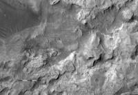
Quick update. I'm working on an extreme closeup map of this site for the next one.
Phil
-------------------- ... because the Solar System ain't gonna map itself.
Also to be found posting similar content on https://mastodon.social/@PhilStooke Maps for download (free PD: https://upload.wikimedia.org/wikipedia/comm...Cartography.pdf NOTE: everything created by me which I post on UMSF is considered to be in the public domain (NOT CC, public domain) |
|
|
|
|
|
|
Jun 8 2015, 06:08 PM
Post
#625
|
|
|
Member Group: Members Posts: 894 Joined: 15-June 09 From: Lisbon, Portugal Member No.: 4824 |
Update to Sol 997.
Fernando
MSL_Curiosity_Route_Map_Sol_0997_2015JUN08.kmz ( 249.97K )
Number of downloads: 579 |
|
|
|
|
Jun 15 2015, 01:07 AM
Post
#626
|
||
|
Solar System Cartographer Group: Members Posts: 10158 Joined: 5-April 05 From: Canada Member No.: 227 |
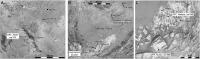
Three close-ups at once to document recent activities.
Phil
-------------------- ... because the Solar System ain't gonna map itself.
Also to be found posting similar content on https://mastodon.social/@PhilStooke Maps for download (free PD: https://upload.wikimedia.org/wikipedia/comm...Cartography.pdf NOTE: everything created by me which I post on UMSF is considered to be in the public domain (NOT CC, public domain) |
|
|
|
|
|
|
Jun 15 2015, 02:36 PM
Post
#627
|
|
|
Junior Member Group: Members Posts: 31 Joined: 1-July 13 From: Ithaca, NY Member No.: 6966 |
Saw this in my google news feed this morning, hope it's okay to post here:
http://www.wired.com/2015/06/amateur-maps-...er-rival-nasas/ Some good explanation of the process and purpose of this very thread. Thanks for your efforts. |
|
|
|
|
Jun 15 2015, 03:25 PM
Post
#628
|
|
|
Senior Member Group: Members Posts: 1074 Joined: 21-September 07 From: Québec, Canada Member No.: 3908 |
I wouldn't call Phil Stooke an "amateur". And by the way, the article mentions Mars being "about 140 billion miles away". Sigh!
|
|
|
|
|
Jun 15 2015, 03:59 PM
Post
#629
|
|
|
Solar System Cartographer Group: Members Posts: 10158 Joined: 5-April 05 From: Canada Member No.: 227 |
I wouldn't call me an astronomer, either!
Phil -------------------- ... because the Solar System ain't gonna map itself.
Also to be found posting similar content on https://mastodon.social/@PhilStooke Maps for download (free PD: https://upload.wikimedia.org/wikipedia/comm...Cartography.pdf NOTE: everything created by me which I post on UMSF is considered to be in the public domain (NOT CC, public domain) |
|
|
|
|
Jun 15 2015, 07:51 PM
Post
#630
|
|
|
Member Group: Members Posts: 910 Joined: 4-September 06 From: Boston Member No.: 1102 |
Astronomer / cartographer / philosopher are all qualities of a Renaissance man or scientist of old. They were mostly amateurs as they had to hold real jobs to feed themselves--such as teacher or cleric. Or you could do science as a hobby if you were wealthy...
Phil does a great job in the 21 century and would no doubt have done well as a cartographer/scientist in centuries gone by as well. Most laypersons upon seeing Phil's maps of distant objects in our solar system would probably come up with the word astronomer before the word cartographer for the one who created them--so I'm fine with Phil being an astronomer... -------------------- |
|
|
|
|

|
Lo-Fi Version | Time is now: 5th May 2024 - 09:39 PM |
|
RULES AND GUIDELINES Please read the Forum Rules and Guidelines before posting. IMAGE COPYRIGHT |
OPINIONS AND MODERATION Opinions expressed on UnmannedSpaceflight.com are those of the individual posters and do not necessarily reflect the opinions of UnmannedSpaceflight.com or The Planetary Society. The all-volunteer UnmannedSpaceflight.com moderation team is wholly independent of The Planetary Society. The Planetary Society has no influence over decisions made by the UnmannedSpaceflight.com moderators. |
SUPPORT THE FORUM Unmannedspaceflight.com is funded by the Planetary Society. Please consider supporting our work and many other projects by donating to the Society or becoming a member. |
|