First public release of Kaguya data |

  |
First public release of Kaguya data |
 Nov 6 2009, 11:02 PM Nov 6 2009, 11:02 PM
Post
#61
|
|
|
Founder  Group: Chairman Posts: 14431 Joined: 8-February 04 Member No.: 1 |
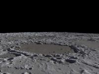
Exagerated rendering : http://www.youtube.com/watch?v=A3MxCvjQDzk and once processed by vimeo http://vimeo.com/7479346
Also uploading to http://www.dougellison.com/dougstuff/kaguy...render_1080.mov - About 10 meg. |
 |
 
|
|
Nov 7 2009, 12:22 AM
Post
#62
|
|
 Senior Member Group: Members Posts: 3648 Joined: 1-October 05 From: Croatia Member No.: 523 |
Oooh, exaggerated is right! Looks great. And kind of creepy, too.
-------------------- |
|
|
|
|
Nov 7 2009, 02:33 AM
Post
#63
|
||
|
Junior Member Group: Members Posts: 23 Joined: 6-November 09 Member No.: 5017 |
My thanks to everyone who made the 16-bit grayscale map possible. I don't have the time right now to play with applying the map to a sphere as I would in Maya or Lightwave, but I have been able to trim out pieces of the map to drop into Terragen, and am very encouraged by the results for use in future artwork. As Bjorn has shown, the data does become somewhat blob-like close up, but Terragen's textures help a bit. This also gets me very excited over the possibilities for using the LOLA data when it becomes available in the coming months.
Rick
|
|
|
|
|
|
|
Nov 7 2009, 04:26 AM
Post
#64
|
|
|
Junior Member Group: Members Posts: 35 Joined: 28-September 05 From: Seattle, WA Member No.: 514 |
Joining in the spinning Moon video party... Here's the Moon rendered with a specular highlight to emphasize topography:
http://www.youtube.com/watch?v=agMcK77p3Hc The overall effect is of looking at a plastic globe. EDIT: Uploaded the wrong video the first time. As pointed out by FordPrefect, there was a 180 degree offset between the normal and albedo maps. --Chris |
|
|
|
|
Nov 7 2009, 05:22 AM
Post
#65
|
|
|
Member Group: Members Posts: 890 Joined: 18-November 08 Member No.: 4489 |
For the past 1 1/2 days i have been trying to get yout???? to except my moon vid ( like the deimos and phobos ) but youtub keeps mangling and f'ing up the ogg file .
http://www.zshare.net/download/68108952dcb3c6a7/ http://www.youtube.com/watch?v=lqxLrig6tQc |
|
|
|
|
Nov 7 2009, 10:36 AM
Post
#66
|
|
|
Junior Member Group: Members Posts: 41 Joined: 12-April 06 Member No.: 738 |
Fantastic Work everyone! I've been hoping for such a DEM since 2003. Spectacular, this global Moon DEM rocks!
QUOTE (claurel @ Nov 7 2009, 05:26 AM)  Joining in the spinning Moon video party... Here's the Moon rendered with a specular highlight to emphasize topography: http://www.youtube.com/watch?v=dZCcYIYq5Ok Chris, it seems your DEM map is shifted by 180 degrees in relation to your albedo texture there. |
|
|
|
|
Nov 7 2009, 01:13 PM
Post
#67
|
|
|
Newbie Group: Members Posts: 8 Joined: 20-April 05 Member No.: 276 |
QUOTE (mhoward @ Nov 6 2009, 08:50 PM) Virtual Moon Atlas looks like it doesn't do topopgraphic lighting, so that would be more of a reach. This must change! A new version is in progress and I have added normal map lightning last summer even I was not very happy with the map I can build before this data release. I have downloaded the Kaguya data and I just start to play with them, it look great! This must be released before the end of the year. Patrick |
|
|
|
|
Nov 8 2009, 05:20 PM
Post
#68
|
|||
 Senior Member Group: Moderator Posts: 3431 Joined: 11-August 04 From: USA Member No.: 98 |
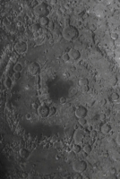
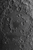
Not just a movie party - a lunar software convention!
Here's a comparison that may be interesting. The first screenshot is Moon Globe with its original, lame pre-Kayuga normal map, and the second is Moon Globe 1.1 with the same view, using my version of the LALT normal map. I've just submitted Moon Globe 1.1 to the App Store, so with any luck it should be showing up in two weeks or so.
Attached thumbnail(s)
|
||
|
|
|
||
|
Nov 8 2009, 08:26 PM
Post
#69
|
|
|
Junior Member Group: Members Posts: 35 Joined: 28-September 05 From: Seattle, WA Member No.: 514 |
Has anyone else noticed a slight misalignment between the Kaguya LALT map and existing albedo maps, specifically those from Clementine?
--Chris |
|
|
|
|
Nov 8 2009, 08:40 PM
Post
#70
|
|
|
Solar System Cartographer Group: Members Posts: 10145 Joined: 5-April 05 From: Canada Member No.: 227 |
Map control from altimeters is much better than the old control - MOLA is the standard for Mars, for instance. In this case the Kaguya control will be far superior to the old Unified Lunar Control Network, which is a mix of control points from Clementine and older missions, basically tens of thousands of points measured on overlapping images. Ultimately we can expect to see older datasets like the Clementine and Lunar Orbiter mosaics, plus the LRO wide angle mosaic, all converted to the altimetry control. LOLA will be the ultimate standard just because of its its high density.
Phil -------------------- ... because the Solar System ain't gonna map itself.
Also to be found posting similar content on https://mastodon.social/@PhilStooke NOTE: everything created by me which I post on UMSF is considered to be in the public domain (NOT CC, public domain) |
|
|
|
|
Nov 9 2009, 07:16 PM
Post
#71
|
|
|
Junior Member Group: Members Posts: 35 Joined: 28-September 05 From: Seattle, WA Member No.: 514 |
QUOTE (Phil Stooke @ Nov 8 2009, 12:40 PM) Map control from altimeters is much better than the old control... Thanks for your answer, Phil. It sounds like there's nothing to be done about the misalignment for now, but it's good to understand the source of it. --Chris |
|
|
|
|
Nov 9 2009, 07:56 PM
Post
#72
|
|
|
Founder Group: Chairman Posts: 14431 Joined: 8-February 04 Member No.: 1 |
QUOTE (Phil Stooke @ Nov 2 2009, 02:54 PM) So back to the database search. Select LISM datasets, search on Tycho coordinates, then choose TC orthomap, and bingo, lots of datasets. I've had no luck with this yet - how are you using the four coordinates, are you ignoring the time fields, and which instrument sets, specifically are you using. |
|
|
|
|
Nov 9 2009, 08:17 PM
Post
#73
|
|
|
Senior Member Group: Moderator Posts: 3431 Joined: 11-August 04 From: USA Member No.: 98 |
QUOTE (claurel @ Nov 8 2009, 02:26 PM) Has anyone else noticed a slight misalignment between the Kaguya LALT map and existing albedo maps, specifically those from Clementine? I may be mis-remembering here, but if memory serves, there have been two different versions of the Clementine albedo map. I think I'm using the later one - it had some new holes in it that I had to patch up. Whatever I'm using, it seems to me to agree quite well with the LALT data. Again I may be way off here, but the later-model Clementine albedo map might have been re-projected after the Clementine laser altimeter results? |
|
|
|
|
Nov 9 2009, 09:09 PM
Post
#74
|
|
|
Solar System Cartographer Group: Members Posts: 10145 Joined: 5-April 05 From: Canada Member No.: 227 |
Clem laser altimetry was such low resolution that it doesn't help very much here. It's absorbed into the Unified Lunar Control Network. The point really is that, if the Kaguya team did their work properly, which they presumably did, their result will be better than anything older. If there's a mismatch it's more likely to be with the older dataset.
Doug: "I've had no luck with this yet - how are you using the four coordinates, are you ignoring the time fields, and which instrument sets, specifically are you using." First, from the data search page, click product selection - it opens a new window. In it I choose LISM and click 'add all'. The datasets appear in the righthand window. Second, choose (for example) LISM/MAP/TC-Morning-Map, then click 'determination'. Back to the first window - now I select data from that dataset. I ignore time, I use coordinates that bracket an area I'm interested in. For instance, Tycho, lat range -40 to -50, long range 340 to 359. Then click 'search execution'. That takes me to a new page, 'list of search result'. It shows nothing until I again choose the TC morning map line from the product box. But then it lists lots of products, 28 tiles of the big mosaic map. Choose one - click on the file name to see metadata and a thumbnail. Click the order box to order it, and it's put on an FTP server for you. An email tells you how to get it. I have one - it has to be unzipped. I'm still trying to open it, but too busy to do much yet. Phil -------------------- ... because the Solar System ain't gonna map itself.
Also to be found posting similar content on https://mastodon.social/@PhilStooke NOTE: everything created by me which I post on UMSF is considered to be in the public domain (NOT CC, public domain) |
|
|
|
|
Nov 9 2009, 09:24 PM
Post
#75
|
|
|
Senior Member Group: Moderator Posts: 3431 Joined: 11-August 04 From: USA Member No.: 98 |
QUOTE (Phil Stooke @ Nov 9 2009, 03:09 PM) Clem laser altimetry was such low resolution that it doesn't help very much here. It's absorbed into the Unified Lunar Control Network. The point really is that, if the Kaguya team did their work properly, which they presumably did, their result will be better than anything older. If there's a mismatch it's more likely to be with the older dataset. Thanks for the correction. Still, I believe there was a version 1 of the Clementine albedo map that was pre-Lunar Control Network, even. If you happen to be using that, I imagine it doesn't match up with the LALT data very well at all. |
|
|
|
|

|
Lo-Fi Version | Time is now: 16th April 2024 - 06:45 PM |
|
RULES AND GUIDELINES Please read the Forum Rules and Guidelines before posting. IMAGE COPYRIGHT |
OPINIONS AND MODERATION Opinions expressed on UnmannedSpaceflight.com are those of the individual posters and do not necessarily reflect the opinions of UnmannedSpaceflight.com or The Planetary Society. The all-volunteer UnmannedSpaceflight.com moderation team is wholly independent of The Planetary Society. The Planetary Society has no influence over decisions made by the UnmannedSpaceflight.com moderators. |
SUPPORT THE FORUM Unmannedspaceflight.com is funded by the Planetary Society. Please consider supporting our work and many other projects by donating to the Society or becoming a member. |
|