MSL Route Map |

  |
MSL Route Map |
 Jan 10 2021, 08:03 AM Jan 10 2021, 08:03 AM
Post
#1456
|
||
|
Solar System Cartographer  Group: Members Posts: 10159 Joined: 5-April 05 From: Canada Member No.: 227 |
Update for sol 2995, retracing tracks to look at a few rocks bypassed earlier.
Phil
-------------------- ... because the Solar System ain't gonna map itself.
Also to be found posting similar content on https://mastodon.social/@PhilStooke Maps for download (free PD: https://upload.wikimedia.org/wikipedia/comm...Cartography.pdf NOTE: everything created by me which I post on UMSF is considered to be in the public domain (NOT CC, public domain) |
|
 |
 
|
|
|
Jan 11 2021, 12:08 PM
Post
#1457
|
||
|
Senior Member Group: Members Posts: 2920 Joined: 14-February 06 From: Very close to the Pyrénées Mountains (France) Member No.: 682 |
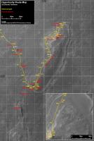
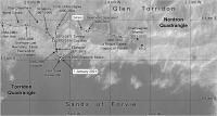
On July 12th 2012, one month before Curiosity landing, Old friend Eduardo posted this map a few sols after Oppy crossed the 3000 sols mark as will do Cury tomorrow.
I was wondering where we where by then... such a long time ago. Heres the answer.
-------------------- |
|
|
|
|
|
|
Jan 15 2021, 10:39 PM
Post
#1458
|
||
|
Solar System Cartographer Group: Members Posts: 10159 Joined: 5-April 05 From: Canada Member No.: 227 |
It's nice to see that again. And here we are with Curiosity at sol 3000:
The exact path followed on sol 3000 is still conjectural. Phil -------------------- ... because the Solar System ain't gonna map itself.
Also to be found posting similar content on https://mastodon.social/@PhilStooke Maps for download (free PD: https://upload.wikimedia.org/wikipedia/comm...Cartography.pdf NOTE: everything created by me which I post on UMSF is considered to be in the public domain (NOT CC, public domain) |
|
|
|
|
|
|
Jan 19 2021, 11:44 PM
Post
#1459
|
||
|
Solar System Cartographer Group: Members Posts: 10159 Joined: 5-April 05 From: Canada Member No.: 227 |
Conjecturing again for the path, but Paul's partial panorama gives a good location for sol 3005.
Phil
-------------------- ... because the Solar System ain't gonna map itself.
Also to be found posting similar content on https://mastodon.social/@PhilStooke Maps for download (free PD: https://upload.wikimedia.org/wikipedia/comm...Cartography.pdf NOTE: everything created by me which I post on UMSF is considered to be in the public domain (NOT CC, public domain) |
|
|
|
|
|
|
Jan 22 2021, 12:36 AM
Post
#1460
|
||
|
Solar System Cartographer Group: Members Posts: 10159 Joined: 5-April 05 From: Canada Member No.: 227 |
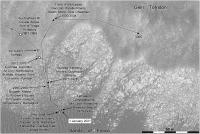
We had a c. 70 m drive on sol 3008, making good progress towards the hills. The position is from Paul's panorama. The JPL map is not updating at the moment so the path is still guessed between stops, but the stops should be pretty good.
Phil
-------------------- ... because the Solar System ain't gonna map itself.
Also to be found posting similar content on https://mastodon.social/@PhilStooke Maps for download (free PD: https://upload.wikimedia.org/wikipedia/comm...Cartography.pdf NOTE: everything created by me which I post on UMSF is considered to be in the public domain (NOT CC, public domain) |
|
|
|
|
|
|
Jan 22 2021, 04:50 AM
Post
#1461
|
|
 Senior Member Group: Members Posts: 2428 Joined: 30-January 13 From: Penang, Malaysia. Member No.: 6853 |
QUOTE (Phil Stooke @ Jan 22 2021, 08:36 AM)  We had a c. 70 m drive on sol 3008.... The SPICE/NAIF post drive file with lat/lon took a while to update, but they concur  Planetocentric longitude: 137.401190581490° Planetocentric latitude: -4.733529048236° |
|
|
|
|
Jan 22 2021, 08:31 AM
Post
#1462
|
|
|
Solar System Cartographer Group: Members Posts: 10159 Joined: 5-April 05 From: Canada Member No.: 227 |
Wow, they have locations down to the nanometer...
Phil -------------------- ... because the Solar System ain't gonna map itself.
Also to be found posting similar content on https://mastodon.social/@PhilStooke Maps for download (free PD: https://upload.wikimedia.org/wikipedia/comm...Cartography.pdf NOTE: everything created by me which I post on UMSF is considered to be in the public domain (NOT CC, public domain) |
|
|
|
|
Jan 23 2021, 01:00 AM
Post
#1463
|
||
|
Solar System Cartographer Group: Members Posts: 10159 Joined: 5-April 05 From: Canada Member No.: 227 |
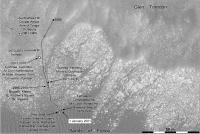
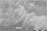
This is an update to the sol 3005 map with target names and a corrected route. I have changed the update name 'Jarishof' to what it is presumably supposed to be, Jarlshof. That will have to be changed back if the error propagates into the PDS because my map has to match the PDS record.
Phil
-------------------- ... because the Solar System ain't gonna map itself.
Also to be found posting similar content on https://mastodon.social/@PhilStooke Maps for download (free PD: https://upload.wikimedia.org/wikipedia/comm...Cartography.pdf NOTE: everything created by me which I post on UMSF is considered to be in the public domain (NOT CC, public domain) |
|
|
|
|
|
|
Jan 23 2021, 03:02 AM
Post
#1464
|
|
|
Senior Member Group: Members Posts: 2428 Joined: 30-January 13 From: Penang, Malaysia. Member No.: 6853 |
QUOTE (Phil Stooke @ Jan 23 2021, 09:00 AM) I have changed the update name 'Jarishof' to what it is presumably supposed to be, Jarlshof.... I noticed that mis-spelling in the mission update. I spent an enjoyable few hours at the archaeological site Jarlshof, when I was working on Shetland back in the winter of '79 (seems like yesterday). Lovely place but a tad windswept. |
|
|
|
|
Jan 25 2021, 06:38 PM
Post
#1465
|
||
|
Solar System Cartographer Group: Members Posts: 10159 Joined: 5-April 05 From: Canada Member No.: 227 |
We had a c. 40 m drive east on sol 3011.
Phil
-------------------- ... because the Solar System ain't gonna map itself.
Also to be found posting similar content on https://mastodon.social/@PhilStooke Maps for download (free PD: https://upload.wikimedia.org/wikipedia/comm...Cartography.pdf NOTE: everything created by me which I post on UMSF is considered to be in the public domain (NOT CC, public domain) |
|
|
|
|
|
|
Jan 27 2021, 12:27 AM
Post
#1466
|
|
|
Solar System Cartographer Group: Members Posts: 10159 Joined: 5-April 05 From: Canada Member No.: 227 |
If you have ever wondered what all these maps would look like joined together... here they are. I think you can download it, let me know if it doesn't work (you may have to view it and then save it).
https://www.dropbox.com/s/ytnkfwfdiklpnjh/c...averse.jpg?dl=0 The maps were not designed to be joined like this so the overlaps don't work well but it gives you an idea of the whole traverse. I did this to make sure I had not mislabelled the grid, accounting for the positioning error discussed recently. I think the labels are OK. Phil -------------------- ... because the Solar System ain't gonna map itself.
Also to be found posting similar content on https://mastodon.social/@PhilStooke Maps for download (free PD: https://upload.wikimedia.org/wikipedia/comm...Cartography.pdf NOTE: everything created by me which I post on UMSF is considered to be in the public domain (NOT CC, public domain) |
|
|
|
|
Jan 27 2021, 01:16 AM
Post
#1467
|
|
|
Senior Member Group: Members Posts: 2428 Joined: 30-January 13 From: Penang, Malaysia. Member No.: 6853 |
QUOTE (Phil Stooke @ Jan 27 2021, 08:27 AM) If you have ever wondered what all these maps would look like joined together... here they are.... That's mightily impressive Phil
|
|
|
|
|
Jan 27 2021, 05:46 AM
Post
#1468
|
|
 Senior Member Group: Members Posts: 1085 Joined: 19-February 05 From: Close to Meudon Observatory in France Member No.: 172 |
QUOTE (Phil Stooke @ Jan 27 2021, 01:27 AM) If you have ever wondered what all these maps would look like joined together... here they are. I think you can download it, let me know if it doesn't work (you may have to view it and then save it). The maps were not designed to be joined like this so the overlaps don't work well but it gives you an idea of the whole traverse. I did this to make sure I had not mislabelled the grid, accounting for the positioning error discussed recently. I think the labels are OK. Phil Congratulations Phil for this impressive work of yours 
|
|
|
|
|
Jan 27 2021, 08:02 AM
Post
#1469
|
||
|
Solar System Cartographer Group: Members Posts: 10159 Joined: 5-April 05 From: Canada Member No.: 227 |
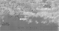
Merci! Paul's partial panorama and the Hazcams give me this position for sol 3013.
Phil
-------------------- ... because the Solar System ain't gonna map itself.
Also to be found posting similar content on https://mastodon.social/@PhilStooke Maps for download (free PD: https://upload.wikimedia.org/wikipedia/comm...Cartography.pdf NOTE: everything created by me which I post on UMSF is considered to be in the public domain (NOT CC, public domain) |
|
|
|
|
|
|
Jan 29 2021, 07:31 PM
Post
#1470
|
|
 Member Group: Members Posts: 895 Joined: 15-June 09 From: Lisbon, Portugal Member No.: 4824 |
Update to sol 3015.
Fernando  The_Martian_Way_MSL_Curiosity_Sol_3015_2021JAN29.kmz ( 822.31K )
Number of downloads: 127
The_Martian_Way_MSL_Curiosity_Sol_3015_2021JAN29.kmz ( 822.31K )
Number of downloads: 127 |
|
|
|
|

|
Lo-Fi Version | Time is now: 6th May 2024 - 09:55 PM |
|
RULES AND GUIDELINES Please read the Forum Rules and Guidelines before posting. IMAGE COPYRIGHT |
OPINIONS AND MODERATION Opinions expressed on UnmannedSpaceflight.com are those of the individual posters and do not necessarily reflect the opinions of UnmannedSpaceflight.com or The Planetary Society. The all-volunteer UnmannedSpaceflight.com moderation team is wholly independent of The Planetary Society. The Planetary Society has no influence over decisions made by the UnmannedSpaceflight.com moderators. |
SUPPORT THE FORUM Unmannedspaceflight.com is funded by the Planetary Society. Please consider supporting our work and many other projects by donating to the Society or becoming a member. |
|