Printable Version of Topic
Click here to view this topic in its original format
Unmanned Spaceflight.com _ MSL _ Journey to Mt Sharp - Part 1: Site 7 to Waypoint 1
Posted by: SFJCody Jul 6 2013, 04:30 PM
http://astrogeology.usgs.gov/news?id=news/sol-326-update-on-curiosity-from-usgs-scientist-ken-herkenhoff-road-trip


Here we go then! Mountain bound! Looks like a new thread may be in order, too.
Posted by: mhoward Jul 6 2013, 04:41 PM
The journey has begun! Time for a new topic. The title and description may change as we get more information about Curiosity's immediate next steps.
Posted by: EdTruthan Jul 6 2013, 07:07 PM
Nice views Airbag. Those appear to have MC34 (for stereo) counterparts not yet in too! Sweet.
Navcam Stereo Anaglyph of the old Sol 120 and new tracks - taken leaving Shaler Sol 324:
http://www.edtruthan.com/mars/Sol324-Navcam-Tracks-From-Shaler-Anaglyph.jpg
Posted by: Explorer1 Jul 7 2013, 12:18 AM
It's funny, parts of it look almost traversable from this distance. If there's an actual safe corridor through it would be a serious shortcut; the dune field is not just one giant purgatory, is it? At the very least they're worth a closer look.
Posted by: Phil Stooke Jul 7 2013, 12:32 AM
Not so much of a short cut, because the actual place they want to reach is down there to the west where there's a way through anyway. I dare say they will take a peek at a bit of dune sand on the way through. (And yes, I DO love those Mastcam mosaics)
Phil
Posted by: Ant103 Jul 7 2013, 01:57 PM
And the Navcam panoramic from Sol 324
http://www.db-prods.net/marsroversimages/Curiosity/2013/Sol324_pano.jpg
"Are we there yet ??" 
Posted by: Phil Stooke Jul 7 2013, 02:23 PM
Very nice - it's going to be exciting to follow this long drive. Here's a circular version of that panorama - or should I say semi-circular? Rocknest is at the top.
Phil
|
Posted by: James Sorenson Jul 8 2013, 03:17 AM
Nice work Airbag and Ed on the Sol-323 Pan
Here is the Sol-325 M34 mosaic of the wheel tracks.
Spherical
http://www.flickr.com/photos/43581439@N08/9234305801/
Vertical
http://www.flickr.com/photos/43581439@N08/9237082436/
EDIT: My take on the Sol-323 M100 Dunefield pan.
http://www.flickr.com/photos/43581439@N08/9238412130/
Posted by: James Sorenson Jul 8 2013, 09:03 AM
Another Drive.
http://www.flickr.com/photos/43581439@N08/9238835282/
http://www.flickr.com/photos/43581439@N08/9236055573/
EDIT: Admins I should have posted this and possibly my previous post in the new drive to Mount Sharp thread. Feel free to move this.
Posted by: Doc Jul 8 2013, 09:59 AM

Phil
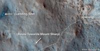
Righto. Just to emphasise Phil's statement as far as how much trekking there's going to be before we strike for the base, here is a http://mars.jpl.nasa.gov/msl/images/Erickson-1_pia17064-br2.jpg showing the corridor of opportunity.
Posted by: Ant103 Jul 8 2013, 11:02 AM
Sol 327 Navcam panoramic. We are on the road for good .
http://www.db-prods.net/marsroversimages/Curiosity/2013/Sol327_pano.jpg
Posted by: Phil Stooke Jul 8 2013, 11:08 AM
Nice. The bright area where the old tracks go is Bathurst Inlet, sol 52.
Phil
Posted by: Phil Stooke Jul 8 2013, 01:50 PM
Ant103's pan in circular form. The rear wheel is touching the south edge of the old track. Incidentally the rear hazcam shows Rocknest, but not very clearly.
Phil
|
Posted by: EdTruthan Jul 8 2013, 04:08 PM
SOL 327 - Hazcam Anaglyhs from the post-drive position, and yup, Rocknest is top center in the rear view, though not much detail is discernible...
Front:
http://www.edtruthan.com/mars/SOL327-Front-Hazcam-Anaglyph.jpg
Rear:
http://www.edtruthan.com/mars/SOL327-Rear-Hazcam-Anaglyph.jpg
Posted by: James Sorenson Jul 9 2013, 08:26 AM
The Sol-327 Chemcam mosaic of the base of Mount Sharp and the dunes. . I'll attempt to overlay mastcam color over this next.
http://www.flickr.com/photos/43581439@N08/9244442883/
EDIT: The chemcam mosaic isn't in this image, but here is the single frame MAHLI image taken on Sol-327 as well.
http://www.flickr.com/photos/43581439@N08/9244731767/
Posted by: Ant103 Jul 9 2013, 11:14 AM
And my take on corrected the tilt of the MaHLI frame
http://www.db-prods.net/marsroversimages/Curiosity/2013/Sol327_MaHLI.jpg
Posted by: James Sorenson Jul 9 2013, 12:34 PM
The ground in front of us on Sol-327
http://www.flickr.com/photos/43581439@N08/9245449005/
Posted by: ngunn Jul 9 2013, 01:27 PM
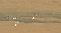
I want to ask about a feature that I have for some time privately been calling the 'blue hill'. It apears at the extreme right of this recent frame peeking over the nearer reddish terrain but in front of the dune-and-canyon lands beyond. I can't find any other extended patch of ground that matches it in colour. It's not dark enough for dune, not red enough for dust and too smooth (one would think) to be naked bedrock. Any thoughts?
http://mars.jpl.nasa.gov/msl-raw-images/msss/00323/mcam/0323MR1314006000E1_DXXX.jpg
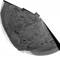
Posted by: Phil Stooke Jul 9 2013, 02:11 PM
This may help with your question. This is a small part of the big Mastcam pan, a perspective distortion, compared with a CTX mosaic to identify features. The CTX mosaic is south-up to match the roughly south-facing Mastcam view. Lines on the CTX show the edges of the section of the pan shown above. Your blue hill is really part of the dune field. There is quite a bit of variability in the dunes, maybe related to when they were last active.
|
EDIT - just noticed my bottom line in the CTX image should be a bit lower to include a bit of outcrop in the dunes.
Posted by: ngunn Jul 9 2013, 03:08 PM
Thanks Phil, that's very helpful, and a very interesting possible explanation potentially providing a handle on dune chronology.
So we may think of recently stabilised dunes turning a paler bluish grey first and only developing a reddish crust over much longer timescales.
Posted by: fredk Jul 9 2013, 03:57 PM
We could see that hill (and other similarly coloured patches) more clearly when we landed - check out these MC views:
http://mars.jpl.nasa.gov/msl-raw-images/msss/00013/mcam/0013ML0015003000E1_DXXX.jpg
http://mars.jpl.nasa.gov/msl-raw-images/msss/00045/mcam/0045MR0208020000E1_DXXX.jpg
Phil, I agree with most of your IDs there, but I think the hill in question is closer:
|
|
Posted by: Phil Stooke Jul 9 2013, 04:19 PM
Very good! Yes, that is a better view. So the 'blue' hill actually is an exposure of a different rock within the dunes.
Phil
Posted by: ngunn Jul 9 2013, 04:48 PM
Or the exposure of a fossil dune among the active ones. It is after all both dune-shaped and quite smooth. (I recall that fossil dunes underlying active ones have been observed on Titan. Maybe there are terrestrial examples too?)
Posted by: dvandorn Jul 9 2013, 06:14 PM
It is obvious from the HiRISE imagery that the dune field is multi-toned, and we see the exact same thing from a distance from Curiosity. However, I'm a little confused as to why a "fossilized" dune would appear more bluish than the darker, assumedly more actively recent dune structures.
If a fossilized dune is of a lighter color than more active dunes because of accumulation of the ubiquitous red surface dust, wouldn't that tend to make the fossilized dunes more reddish than bluish?
I'm wondering whether or not the apparent color difference may indicate a different mineral composition in the different structures within the dune field. Of course, we'll need to wait and see what we find when we get there -- MSL certainly has the tools and sensors required to make that determination once we get there.
-the other Doug
Posted by: ngunn Jul 9 2013, 06:51 PM
That's what I thought at first, but maybe there are two processes at work. When the dune first stabilizes maybe it 'bleaches' relatively quickly due to some process other than dust accumulation.
Curiosity is unlikely to visit that feature so unless there is a similar one close to the place where our traverse threads through the dunes it may not give us a definitive answer. It's probably not a priority question, but fun to think about all the same.
EDIT: It could just be a different kind of bedrock as Phil and Doug have suggested, but then you still have to explain why it remains free of the ubiquitous red dust.
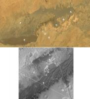
Posted by: fredk Jul 9 2013, 10:51 PM
Nearby is a prominent two-toned hill - I don't recall it being identified before on orbital imagery. Here it is, with the orbital view rotated so the MC view is approximately from the bottom:
|
Edit: replaced with higher resolution orbital view.
Posted by: dvandorn Jul 10 2013, 12:37 AM
The dune fields are multi-toned, it shows up in the HiRISE images and shows up better in the Curiosity images (at least as far as the fine color delineations are concerned).
I also think we need to remember that the human eye tends to apply a contrasting color level to what is essentially gray if it is in contrast with a reddish color. It's been especially true on Mars that what may appear greenish or bluish is actually a pretty neutral gray, the eye seeing a bluish or greenish tint in the absence of the surrounding red.
My best guess is that the dune fields are primarily varying shades of gray, and when we're looking at them from a close-up vantage point we'll see a range of tones from light gray to a dark, almost black gray. (Of course, there is going to be at least a little of the ubiquitous red dust mixed in there, but not a whole lot, from the way it looks from a distance.)
-the other Doug
Posted by: Gerald Jul 10 2013, 02:16 AM
Many more factors will influence color and specularity, e.g. grain size, local wind (dust removal below saltation threshold for sand), surface texture, adherence properties of the surface, abrasion by saltating sand grains during storms.
If we can fix all other parameters, assume low abrasion but high local dust removal, and the dune is made of basalt sand, it might be worth to check, whether color can change from grey to reddish-brown like weathering basalt on Earth. That's at least plausible in an oxidizing environment.
http://www.cs.cmu.edu/afs/cs/academic/class/15462-f09/www/lec/lec8.pdf
http://onlinelibrary.wiley.com/doi/10.1002/(SICI)1096-9837(199709)22:9%3C869::AID-ESP785%3E3.0.CO;2-P/abstract.
http://www.kona.or.jp/search/26_129.pdf.
http://en.wikipedia.org/wiki/Basalt
Posted by: Actionman Jul 10 2013, 11:23 AM
-------------
"If" being the key word. "IF" the dark dune is segregated basalt sand, where is the basalt the sand coming from? directly under the dune?
Posted by: Actionman Jul 10 2013, 11:24 AM
Nice match fredk.
A whole lot of textures going on.
Posted by: Ant103 Jul 10 2013, 12:49 PM
Sol 328 Navcam pan.
http://www.db-prods.net/marsroversimages/Curiosity/2013/Sol328_pano.jpg
I'm pretty sure we can see Rocknest near the left-center of the panorama .
Posted by: Phil Stooke Jul 10 2013, 01:28 PM
Yes, that's Rocknest. This is the back half of the previous pan, making a full 360 degrees before they drove on later in the sol.
Here's a full 360 in a circular projection:
|
Phil
Posted by: Gerald Jul 10 2013, 06:17 PM
Most of it from distant locations, probably from outside Gale Crater where basaltic bedrock is more abundant.
Posted by: Ant103 Jul 10 2013, 06:43 PM
Good point Phil
So, here's the full pan, Sol 327 & 329 :
http://www.db-prods.net/marsroversimages/Curiosity/2013/Sol327_328_pano.jpg
Posted by: dvandorn Jul 10 2013, 07:49 PM
In re the dark dunes, they remind me of El Dorado in Gusev. That dark dune field, while much smaller than the ones ringing Mt. Sharp, looked as dark from a distance and from above as the ones here in Gale. When we got really close to El Dorado, we found there is a thin layer of the ubiquitous red dust on the mini-dune ridges, but it's mostly just black basaltic dust.
I would imagine these dark dunes in Gale formed by a similar process as that which created El Dorado, an area that is wind-shadowed in such a way that the black basaltic grains are preferentially dropped from the general airborne dust entrainment. Or, maybe not exactly a wind shadow, more of a place where Mt. Sharp's effect on the winds causes the exact right kind of instability in the air that causes the preferential deposition.
The big difference between these extensive dune fields here at Gale and the El Dorado field in Gusev is that Mt. Sharp is a much bigger hill than Husband Hill was, so these dune fields are much larger and seem to show some differences in albedo (we'll know about textural differences when we get there), depending on how far away from Mt. Sharp you are (or maybe the angle of repose upon which the dunes formed; the two are sort of interrelated). Could be that the "edges" of the wind instability that causes the preferential deposition show a more well-mixed deposition? Again, something we will know more about when we get there.
In any event, we see this effect literally everywhere on Mars, be it influenced by mountains, crater rims or whatever causes the right kind of instability that causes the preferential deposition. It's certainly not unique to Gale.
-the other Doug
Posted by: Phil Stooke Jul 10 2013, 08:47 PM
A very rough circular half-pan for the 329 location.
Phil
|
Posted by: ngunn Jul 10 2013, 09:17 PM
A very interesting feature also. The dark grey patches look like avalanches that have broken through a brighter red crust, consistent perhaps with the hill being made of sand. Given that we believe Mars experiences big climatic swings it seems reasonable that there might be evidence of multiple eras of dune formation here, in this favoured location (as evidenced by the presence of an active dune system today).
Posted by: EdTruthan Jul 11 2013, 01:08 AM
Sol 329 - Hazcam Anaglyphs from new our position after the 41.05 meter afternoon drive. Tracks from the Sol 52 drive visible at upper right of front view....
Rear:
http://www.edtruthan.com/mars/Sol329-Post-Drive-Rear-Hazcam-Anaglyph.jpg
Front:
http://www.edtruthan.com/mars/Sol329-Post-Drive-Front-Hazcam-Anaglyph.jpg
Posted by: Ant103 Jul 11 2013, 01:24 PM
Sol 329 Navcam pan (and the good one, I've made a mistake between 328 and 329
 ).
).
http://www.db-prods.net/marsroversimages/Curiosity/2013/Sol329_pano.jpg
Posted by: Ant103 Jul 12 2013, 11:28 AM
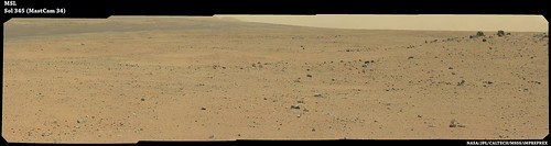
Sol 331 Navcam pan :
http://www.db-prods.net/marsroversimages/Curiosity/2013/Sol331_pano.jpg
Isn't it Jake Matijeivic we can see near the horizon, at the center of the image ?
Posted by: PaulH51 Jul 12 2013, 11:35 AM
It's in the correct position, nice observation Damia
Posted by: Phil Stooke Jul 12 2013, 01:01 PM
Looks like you're right, Damia.
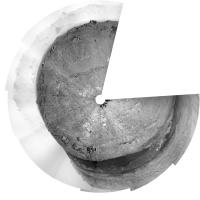
Here's a circular version of that pan:
|
Phil
PS - probably not on the next drive, but on the one after that, we will pass the 1 km mark.
Posted by: fredk Jul 12 2013, 03:50 PM
As you could guess from the sol 331 drive, the plan seems to be to divert south of the old route now. Here's a proposed route from the latest http://mars.jpl.nasa.gov/msl/multimedia/videos/index.cfm?v=134
|
Posted by: EdTruthan Jul 12 2013, 05:18 PM
Onward! Looks like it's all new digs from here then. Here are http://www.unmannedspaceflight.com/index.php?act=attach&type=post&id=30481 Sol331 front and rear Hazcam Anaglyphs...
Front:
http://www.edtruthan.com/mars/Sol331-Post-Drive-Front-Hazcam-Anaglyph.jpg
Rear:
http://www.edtruthan.com/mars/Sol331-Post-Drive-Rear-Hazcam-Anaglyph.jpg
...and thanks as always Phil for the ongoing route map updates. Having the scale bar (
http://www.unmannedspaceflight.com/index.php?s=&showtopic=7442&view=findpost&p=201541) is a really nice addition.
Posted by: Zelenyikot Jul 13 2013, 09:45 AM
My try to make ChemCam panorana on Sol 327.
|
Posted by: wildespace Jul 13 2013, 10:01 AM
Great idea to use MAHLI and MARDI to document the trip to Mt Sharp. I'm particularly looking forward to scenic MAHLI shots. http://astrogeology.usgs.gov/news?id=news%2Fsol-329-update-on-curiosity-from-usgs-scientist-ken-herkenhoff-twilight-wins
Posted by: Actionman Jul 13 2013, 04:49 PM
The dunes in this ChemCam photo do not have a similar signature as the basalt rocks do in the foreground.
Posted by: Phil Stooke Jul 14 2013, 11:15 AM
Another drive on sol 333, but the picture available so far suggests quite a short one. That may be taken along the drive, not at the end, but we'll see.
EDIT - yes, it was taken mid-drive and even the full drive was quite short, moving past a tricky area beside that crater visible in the last panorama. Map update tomorrow.
Phil
Posted by: EdTruthan Jul 14 2013, 11:39 PM
Hazcam Anaglyphs after the 15.48 meter drive on Sol 333...
Front:
http://www.edtruthan.com/mars/Sol333-Post-Drive-Front-Hazcam-Anaglyph.jpg
Rear:
http://www.edtruthan.com/mars/Sol333-Post-Drive-Rear-Hazcam-Anaglyph.jpg
Posted by: Gerald Jul 15 2013, 12:35 AM
Like this one (Sol 329)?
http://imgbox.com/adfCcEKA
Posted by: James Sorenson Jul 15 2013, 03:30 AM
An attempt to stitch the scenic after-drive MAHLI images. No features in the near-field lined up of coarse and I wouldn't trust at all the locations of features near the rover between images, but the dunes and Mt Sharp stitched quite nicely.
http://www.flickr.com/photos/43581439@N08/9290415810/
Posted by: blake Jul 15 2013, 04:10 AM

|
[/url]
You beat me to it. My attempt at this same idea, with map locations, annotated. Attached.
Posted by: James Sorenson Jul 15 2013, 04:36 AM
Good Job Blake! , welcome to Unmanned Spaceflight. That was a good idea to add the Field of View map, and direction info to yours.
Posted by: Gerald Jul 15 2013, 05:30 AM
The trip of two sols (327 to 329) was sufficient to get a visible parallaxe at the dunes and at Mt. Sharp:
http://makeagif.com/W1szQh, based on two overlapping MAHLI image regions.
Posted by: Ant103 Jul 15 2013, 11:52 AM
Sol 333 Navcam pan
http://www.db-prods.net/marsroversimages/Curiosity/2013/Sol333_pano.jpg
Looks like we are climbing a little slope, and that we are going higher.
Posted by: Phil Stooke Jul 15 2013, 01:22 PM
Really nice Mahli pans and stereo!
This is a circular projection of Ant103's panorama from sol 333:

|
Phil
Posted by: neo56 Jul 15 2013, 02:20 PM
What is the white spot we can see on Damia's panorama, on the top right of the UHF antenna, in the rampart of Gale crater ? Is it due to a cosmic ray ?
Posted by: fredk Jul 15 2013, 02:33 PM
Almost certainly. You can see that it's only in the NLB frame, not the NRB frame.
Posted by: exoplanet Jul 15 2013, 05:02 PM
Yikes . . . the wheels look as if they are getting buried . . 
Posted by: Phil Stooke Jul 15 2013, 05:13 PM
Maybe you're looking for a wheel where there isn't one! The wheels are sitting right on top of the surface as you'd expect.
Phil
Posted by: centsworth_II Jul 15 2013, 10:30 PM

|
Posted by: mhoward Jul 16 2013, 12:47 PM
I've moved http://www.unmannedspaceflight.com/index.php?s=&showtopic=7659&view=findpost&p=201686 (including mine) to the "Cumberland, Point Lake and Shaler" thread and cleaned up a bit.
As Phil pointed out, the sol 335 drive has happened.
Posted by: Phil Stooke Jul 16 2013, 01:46 PM
... and this is a circular version of a rough pan from the new location. I included the thumbnails to be sure where that little crater is, helping to establish the location very accurately on the updated map.
Phil

|
Posted by: EdTruthan Jul 16 2013, 04:42 PM
One Kilometer! Congratulations to everyone at JPL and the extended MSL team for their 1st kilometer on the red planet. I posted a few graphic overlays of the route onto a terrestrial background in the http://www.unmannedspaceflight.com/index.php?s=&showtopic=7442&view=findpost&p=201709 for a feel of how large an area the entire traverse from landing till Sol 335 covers. Compared to the distance to Mt. Sharp we've got quite a long journey ahead...
Sol 335 - Post-drive hazcam anaglyphs...
Front:
http://www.edtruthan.com/mars/Sol335-Post-Drive-Front-Hazcam-Anaglyph.jpg
Rear:
http://www.edtruthan.com/mars/Sol335-Post-Drive-Rear-Hazcam-Anaglyph.jpg
Posted by: Ant103 Jul 17 2013, 10:55 AM
Really ? One kilometer ? That was long
So, the first panoramic taken after the first kilometer of Curiosity on Mars. It's about time !
http://www.db-prods.net/marsroversimages/Curiosity/2013/Sol335_pano.jpg
Posted by: Marvin Jul 17 2013, 12:50 PM
Wow, foothills of Mount Sharp, here we come!
Posted by: Phil Stooke Jul 17 2013, 01:28 PM
Another drive - looking like about 40 m again - on sol 336. This is a very quick circular version of the pan so far... not easy to match those little craters to HiRISE but the new route map shows where I think we might be.
Phil

|
Posted by: Ant103 Jul 17 2013, 04:14 PM
The corresponding navcam pan, from Sol 336 :
http://www.db-prods.net/marsroversimages/Curiosity/2013/Sol336_pano.jpg
Posted by: EdTruthan Jul 17 2013, 05:00 PM
...and the post-drive Sol 336 Hazcam Anaglyphs. That big depression we're approaching (& visible in the route maps) is finally discernible on on the left in Damia's pano above.
Front:
http://www.edtruthan.com/mars/Sol336-Post-Drive-Front-Hazcam-Anaglyph.jpg
Rear:
http://www.edtruthan.com/mars/Sol336-Post-Drive-Rear-Hazcam-Anaglyph.jpg
Posted by: Phil Stooke Jul 17 2013, 05:28 PM
Damia's pan was wider than mine, so it allows better location, and I am revising my map. This is the circular version of her pan. Two shallow craters are visible ahead, and we are aiming for the ridge between them
Phil

|
Posted by: EdTruthan Jul 17 2013, 05:52 PM
Here's a quickly rendered Navcam Anaglyph of the big crater at front left. The other depression you mentioned Phil can be partially seen at far right. Yup, for my money that saddle in between them looks like the safest bet...
http://www.edtruthan.com/mars/Sol336-Navcam-3-Frame-Crater-Anaglyph.jpg
Posted by: RichforMars Jul 18 2013, 01:45 PM
Quite a few miles to go. Should be good the following drive ahead.  Vroom vroom!
Posted by: Phil Stooke Jul 18 2013, 02:11 PM
We seem to be out of restricted sols now and moving every day. Here we are on sol 337 up on the start of that ridge between the two craters.
Phil

|
EDIT - and an approximate location:

|
(proper map update later today)
Posted by: Ant103 Jul 18 2013, 09:17 PM
Sol 337 Navcam pan.
http://www.db-prods.net/marsroversimages/Curiosity/2013/Sol337_pano.jpg
Posted by: EdTruthan Jul 18 2013, 09:50 PM
Sol 337 Post-Drive Hazcam Anaglyphs...
Front:
http://www.edtruthan.com/mars/Sol337-Post-Drive-Front-Hazcam-Anaglyph.jpg
Rear:
http://www.edtruthan.com/mars/Sol337-Post-Drive-Rear-Hazcam-Anaglyph.jpg
Posted by: Phil Stooke Jul 19 2013, 02:32 PM
Another drive on sol 328, looking into new territory now.
Phil
EDIT - replaced my rough pan reprojection with one based on Damia's (below) - hers are always much better than mine, which I make quickly just to locate the rover.

|
Posted by: Ant103 Jul 19 2013, 04:35 PM
Sol 338 Navcam pan
http://www.db-prods.net/marsroversimages/Curiosity/2013/Sol338_pano.jpg
This is like a routine now. Turn on the radio, switch to Aeolis FM on 96.3, there's some good ol'rock music there. Road movie on Mars .
Posted by: Explorer1 Jul 19 2013, 04:38 PM
Yep; the rover was made for this sort of work just as much as it was for sitting and analyzing. I suppose the best comparisons is Oppy leaving Eagle and Endurance all those years ago....
Posted by: fredk Jul 19 2013, 05:32 PM
Nice stereo view into the large crater just to our left now:

|

|
Posted by: EdTruthan Jul 19 2013, 06:49 PM
...and a 3 frame navcam anaglyph of the terrain lying just ahead. Interesting. Looks to be a slight depression with a few undulating rises across it's floor, some jagged boulders strewn about, and some very light colored outcrops at left. It's pretty exciting to see some new horizons...
http://www.edtruthan.com/mars/Sol338-3-Panel-Navcam-Anaglyph-View-Ahead.jpg
Posted by: Gerald Jul 20 2013, 10:54 AM
Trying to "dust de-coat" http://mars.jpl.nasa.gov/msl-raw-images/msss/00336/mrdi/0336MD0063000000E1_DXXX.jpg:
http://makeagif.com/ROyIgL.
"De-coated" image:
http://imgbox.com/abge2bMS
The image has been "de-coated" in the following way:
Retrieve the color of one of the darkest spots of the wheel, assumed as black;
fill an image uniformly with that color, darken it a little bit (5-10%);
subtract the the resulting uniformly colored image from the original image;
brighten the resulting difference image by duplicating the pixel values.
Some more improvement may be possible by additional de-vignetting.
Posted by: Phil Stooke Jul 20 2013, 12:30 PM
That was interesting! I had to experiment with it myself. Here's mine:

|
My method - first I cropped out the black borders on three sides. That's important for the high pass filter. Then I copied the image and pasted it over itself to make four identical layers. Each layer was processed differently and the stack was merged (a little trick I've used for years in many contexts - artifacts in each processing method are different so they tend to cancel out).
The first layer got a simple stretch to make the darkest shadows really dark and to brighten the brighter spots. But it gives too much gradient and messes with the saturation. The second layer had saturation reduced to zero (= greyscale) and then a stronger contrast stretch. The third, I used feathered selections at left and right edges to brighten the darker areas, and then a high pass filter to even out shading, followed by a stretch. The fourth layer had the edges brightened again plus a stretch.
The middle two layers lose color information when treated like that. The outer layers retain color with increased saturation. Merge them all, with equal weighting, and the result has reasonable color and good contrast everywhere. Then I sharpened it and adjusted colour balance slightly towards the red.
Phil
Posted by: Phil Stooke Jul 20 2013, 02:14 PM
I won't illustrate it here because the results are just plain ugly... but the mastcam frames of the drive direction that came down very recently - like this one:
http://www.midnightplanets.com/web/MSL/image/00338/0338ML1372000000E1_DXXX.html
... when stretched beyond belief, show the distant wall of Gale all the way round the horizon to Mt. Sharp now. When we landed we could see the walls all the way around except where cut off by Mt. Sharp, but in Yellowknife Bay the hills of Bradbury Rise (where we are now) blocked the distant walls from view to the west. Now they are coming into view again. When the skies clear a bit we should get nice views of the walls again all the way round.
Phil
Posted by: mcaplinger Jul 20 2013, 03:41 PM
Subtracting a constant color is just equivalent to a stretch and color correction. It might be that the dust scattering varies across the field, but it doesn't look like it to me, at least not strongly.
I've gotten OK results by just auto-white-balancing the image and then stretching it a little, since all the dust is doing to first order is tinting the image and reducing contrast. It's a little out-of-focus because MARDI is focused at infinity, and a light high-pass might help that if you like that sort of thing (I avoid high-pass whenever possible because it boosts noise, compression artifacts, etc., but that's mostly a matter of taste.)
Posted by: Zelenyikot Jul 20 2013, 05:07 PM
Sunset from Curiosity on sol 312
http://www.youtube.com/watch?v=BR0cdE1jUyU
http://ic.pics.livejournal.com/zelenyikot/65139567/505/505_600.gif
http://ic.pics.livejournal.com/zelenyikot/65139567/1489/1489_original.gif

|
Posted by: atomoid Jul 21 2013, 07:05 AM
thank you for that, its mesmerizing, and you've managed to get rid of the overexposed bleed on the color gif to reconstruct a beautiful quasispherical sun, and for a moment i thought i was seeing atmospheric refraction shrinking (not magnifying!) the sun as it warbles down past within a diameter's reach of the horizon, but alas that must be an artifact of the colorization or something, for it exists not in the grey version nor the source files.
Posted by: wildespace Jul 21 2013, 10:00 AM
A sequence of MAHLI images documenting the trip, sols 327-338 (one image in the sequence still not up). I hope I got the rotation of the images right.
http://www.pictureshack.us/images/58570_5mzBev1374400142.gif
Posted by: Ant103 Jul 21 2013, 11:16 AM
Sol 338, a Mastcam 34 pan, certainly a kind of drive direction mosaic.
http://www.db-prods.net/marsroversimages/Curiosity/2013/Sol338_Mastcam34.jpg
Posted by: Phil Stooke Jul 21 2013, 02:19 PM
... and the drive just happened on sol 340. More news later when full images are available.
Phil
Posted by: Gerald Jul 21 2013, 02:31 PM
The Sol 337/338 MAHLIs are well-suited for a stereo blink:
http://makeagif.com/g_Sdna.
But for a cross-eye stereo they're rather challenging, so I hesitate to post the latter version.
Posted by: fredk Jul 21 2013, 04:21 PM
Yeah, the drive distance makes a good long baseline for stereo. Here's my attempt at anaglyph and cross-eyed versions:
|
|
|
|
I actually find the cross-eyed version the best to show the depth.
Posted by: Gerald Jul 21 2013, 05:06 PM
That's what I could squeeze out in the meanwhile by stretching brightness and replacing some of the schmutz by my own artifacts:

|
I'm beginning to get an imagination of the canyon located in the lower parts of Mt. Sharp.
Posted by: Phil Stooke Jul 21 2013, 05:15 PM
Image thumbnails plus one navcam suggest to me we are now about here... updated map with extended base coming up on Monday.
EDIT - I pulled that location, I was looking in the wrong place, not expecting such a long drive. This was over 104 m, the longest drive yet by Curiosity. This is the new place on an older base map, proper update Monday.
Phil

|
Posted by: EdTruthan Jul 21 2013, 06:48 PM
Love the stereo images guys. I find the Mt. Sharp base canyons tantalizing too. Combining selected Sol 36 and Sol 42 images offers http://www.edtruthan.com/mars/Sol36-and-42-North-MtSharp-Foothills-Anaglyph.jpg To my eye the strata appears to slope downward toward the crater floor. It reminds me a bit of the terrain in the http://epod.usra.edu/blog/2012/02/san-juan-river-at-raplee-monocline.html near Mexican Hat Utah. Mt. Sharp's sloping strata isn't as drastic of course, but the depositional>uplift or depression>erosional aspects seem quite similar...
A few anaglyphs from Sol 340.....
Front Hazcam:
http://www.edtruthan.com/mars/Sol340-Front-Hazcam-Anaglyph.jpg
Rear Hazcam:
http://www.edtruthan.com/mars/Sol340-Rear-Hazcam-Anaglyph.jpg
2-Frame Navcam of immediate foreground:
http://www.edtruthan.com/mars/Sol340-2-Frame-Navcam-Foreground-Anaglyph.jpg
Posted by: Phil Stooke Jul 21 2013, 07:57 PM
Where next? I think we have come south to avoid the area contaminated by the landing, but if we now keep going due west we will come to the parachute in another 1000 m or so. That's what I would expect right now. Keep going southwest and we hit some very rugged terrain.
This would have been the first full use of the new autonav software (may have been used for shorter test drives earlier). I would hope that 100 m would be a common day's driving distance after this.
Here's a feature comparison to establish location. The positions in jmknapp's map are drifting off from the real location, as predicted positions always do (not his fault! It's the JPL positions which are off.)

|
Phil
Posted by: Explorer1 Jul 21 2013, 10:28 PM
Looks like an outcrop of some sort on top of the hill (and probably a view to boot).
Posted by: Zelenyikot Jul 21 2013, 10:53 PM
Yes it is an artifact of processing when I tried to get rid of a blooming.
Posted by: Ant103 Jul 22 2013, 10:18 AM
Very incomplete Sol 340 navcam pan :
http://www.db-prods.net/marsroversimages/Curiosity/2013/Sol340_pano.jpg
Posted by: EdTruthan Jul 22 2013, 09:35 PM
Sol 341 - Morning Hazcam Anaglyphs...
If a western tack is indeed the plan, a Google Mars measurement puts the Backshell at only 668 meters away from Phil's last marked position at Sol 340, at an azimuth of about 272 degrees (& the center of the Parachute about 269 degrees). According to the meta-data the front shot below centers at about 242 degrees making the direction of the Backshell somewhere off to the right of center. Don't see anything there yet, but then we're still pretty far off...
Front:
http://www.edtruthan.com/mars/Sol341-Front-Hazcam-Anaglyph.jpg
Rear:
http://www.edtruthan.com/mars/Sol341-Rear-Hazcam-Anaglyph.jpg
Posted by: Phil Stooke Jul 22 2013, 09:52 PM
Several updates all at once from Ken Herkenhoff:
http://astrogeology.usgs.gov/
- a bit more detail on the driving software.
Phil
Posted by: Gerald Jul 22 2013, 11:15 PM
Five Sol 340 Mastcam Left images autostitched with moderate quality (no pre-/postprocessing) for those who can't wait:
http://imgbox.com/abetf030
Posted by: Ant103 Jul 23 2013, 12:34 PM
It's best with exposure adjustment between frames 
http://www.db-prods.net/marsroversimages/Curiosity/2013/Sol340_Mastcam34.jpg
Posted by: Gerald Jul 23 2013, 12:52 PM
Thanks Damia! Patience pays for waiting for the true experts!
Here the Sol 340 Mardi, strongly dust-decoated:
(http://makeagif.com/4hos5e)
Link to (strongly) decoated image:
http://imgbox.com/actTtTn1
Most of the (more or less) ellipse-shaped saturation gradient (obtained by subtracting a uniformly colored image) has been removed by assuming non-uniform light scattering roughly proportional to low-pass brightness:
- 2pixel-radius Gauss blur applied to reduced (to 20 pixel maximum length) cropped image has been yielding the basis for the brightness channel,
- pixel value of darkest region of wheel (assumed as black after dust-decoating) used as hue/saturation,
- HSL-channel combined image with some darkening subtracted from the raw image,
- brightening of the difference by tripling the pixel values.
Posted by: Gerald Jul 23 2013, 05:14 PM
Sol 340 drive as seen from Navcam Right B (from 51 NRB images, resized to 512x512, 8.5 MB):
http://imgbox.com/abhsSXfF
Posted by: Phil Stooke Jul 23 2013, 05:14 PM
Another drive on sol 342. First guess - about a 60 m drive to the SW, towards that rocky lump on the hilltop.
Phil

|
Posted by: Phil Stooke Jul 23 2013, 06:00 PM
Great view of the hills of Gale's northern walls.
Phil
|
|
Posted by: EdTruthan Jul 23 2013, 06:16 PM
...and a quick Sol 342 5-frame navcam anaglyph. There's more terrain details toward the south now visible. (Exposure values for ground detail washed out those nice crater rims at upper right though...)
http://www.edtruthan.com/mars/Sol342-Navcam-5-Panel-Anaglyph.jpg
Posted by: Ant103 Jul 23 2013, 07:11 PM
Sol 342 Navcam pan :
http://www.db-prods.net/marsroversimages/Curiosity/2013/Sol342_pano.jpg
The view is getting better and better on the various hills on the horizon, and on the dunes at the foothills of Sharp/Aeolis .
Posted by: fredk Jul 23 2013, 07:31 PM
Yeah, it's good to see the view open up again. I hope we can stop at a local rise somewhere around here, to get an even better view. If we don't visit the 'chute/backshell, MC100 might still give a very good view from atop a rise.
Posted by: Phil Stooke Jul 23 2013, 09:20 PM
This shows where we are relative to the parachute - after I started making it I realised the background image was not map-projected, so I aligned the route with it but it's slightly off relative to other maps. But for rough positions it will do for now.
Phil

|
Posted by: Gerald Jul 24 2013, 05:24 PM
Sol 342 Mastcam Left autostitch:
http://imgbox.com/adzTZ4Zm
Posted by: Phil Stooke Jul 24 2013, 05:29 PM
Sol 343 - moving closer to that ridge. I hope we get a name for it soon.
Phil

|
Posted by: Phil Stooke Jul 24 2013, 07:54 PM
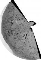
There's a nice new HiRISE image out:
http://www.jpl.nasa.gov/news/news.php?release=2013-233
It's shot at almost zero phase, so no shadows, but it shows albedo (and tracks) very well. This is a crop from the JP2 version showing the parachute, which has moved around a bit (folded over itself) since landing.
Phil

|
Posted by: EdTruthan Jul 24 2013, 11:14 PM
Sol 343 Navcam Anaglyph - This covers over 240 degrees of horizon from the dunes to the crater rim (the frames center from 230 at left to 9.86 degrees at right). Tried to tweak the levels to retain a good balance between foreground and crater rim so as to preserve some rim detail this time.
There's some very bright material near the top or just beyond of one of the knolls a bit left of center. It's not the right direction for the backshell though. But off to right of center there's a rocky crag that juts up just above the horizon that's at about 275 degrees azimuth. I get an azimuth reading (in Google Mars) of 276 degrees to the backshell now at a distance of about 617 meters. So that'd put backshell and parachute on the other side of that rocky knoll I figure.
I looked for signs of the Skycrane impact (304 degrees at 820 meters) and Bradbury Landing (342 degrees at 260 meters) but at this resolution, even if they're visible from here, it's a real stretch. There's a bright patch of ground in the direction of the landing site (middle right of pano) that's visible just over a small rise, but upon inspection it looks to be the lighter colored ground area visible NNW of the Sol 343 position rather than Bradbury. In any case, gotta love the views from up here!
http://www.edtruthan.com/mars/Sol343-9-Frame-Navcam-Panorama-Anaglyph.jpg
Posted by: Zelenyikot Jul 25 2013, 07:29 AM
It seems how new pebbles.

|
Posted by: Ant103 Jul 25 2013, 09:51 AM
Sol 342 Mastcam34 panorama :
http://www.db-prods.net/marsroversimages/Curiosity/2013/Sol342_Mastcam34.jpg
Sol 343 Navcam panorama :
http://www.db-prods.net/marsroversimages/Curiosity/2013/Sol343_pano.jpg
Starting tomorrow, I will not be home, I will spent some days in Bourgogne, in France, and I will not be able to process pictures (I will try to do some if possible).
Posted by: Phil Stooke Jul 25 2013, 02:00 PM
This is a sol 343 Navcam pan of the walls of Gale. Imagine what the Mastcam-100 would show!
Phil
|
|
Posted by: Phil Stooke Jul 25 2013, 06:57 PM
Another drive - no stopping at that ridge, we are past it now, probably heading around the south side of the very rocky hilltop to the west. This was about a 70 m drive and we are just about exactly south of the landing site.
Phil

|
Posted by: iMPREPREX Jul 25 2013, 07:45 PM
My take on 343's MastCam 34 mosaic with HiRISE imagery and route map (thanks to Joe Knapp). I apologize for my projection. It looks "off", but what the heck: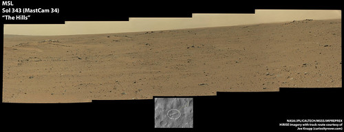
Full size:
http://www.flickr.com/photos/84750994@N05/9368110128/sizes/o/
And here's a cropped image with a tad of added sky for wallpaper, if you think it's nice enough (sol 342). 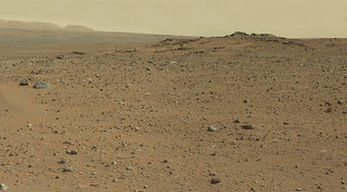
Full size:
http://www.flickr.com/photos/84750994@N05/9361946916/sizes/o/
Posted by: EdTruthan Jul 25 2013, 07:45 PM
...and the Sol 344 horizonal anaglyph. Nice view of that rocky knoll at right now. Still no sign of the backshell over in that direction but at this distance it might not even be visible when we round that knoll if it's in a depression. We'll see. Based on Phil's Sol 344 route map position, a GM measurement now puts it at about 550 meters almost directly on the other side of that knoll (and just a little to the left of it actually). Wonder what kind of material is so white in that knoll at center left? (For those following along I only render the upper half of the navcam frames for these horizonal views as it expediates the channel alignment routine while still providing a good sense of the surrounding terrain.)
http://www.edtruthan.com/mars/Sol344-8-Frame-Navcam-Panorama-Anaglyph.jpg
Posted by: fredk Jul 25 2013, 10:22 PM
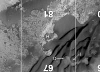
Based on the elevation map http://www.petergrindrod.net/archives/858, it looks like we shouldn't be able to see the 'chute/backshell yet, due to obscuring hills. Here's a crop with our current location and the hardware (red dots):

|
Once we're more directly south of the 'chute/backshell, we may get a view...
Stepping back, we seem to be on a subtle NW-SE running ridge at the moment, and likely at about our highest elevation until we're substantially closer to the dune field (red dot shows sol 344 location):

|
(From http://www.nasa.gov/mission_pages/msl/multimedia/grotzinger-1.html.)
Posted by: atomoid Jul 26 2013, 01:22 AM
for anaglyph-challenged to make benefit lackluster cross-o-gram topography preview in general drive direction..

|
Posted by: Gerald Jul 26 2013, 01:10 PM
Post-drive MAHLIs for Sols 342, 343, and 344:
http://imgbox.com/adzRvBeR http://imgbox.com/adfkQ8YN http://imgbox.com/abiklz8m
Images are rotated 150 degrees. That's an estimate of the rotation (around MAHLI z-axis) of the MAHLI camera relative to the rover frame when the arm is stowed.
See also http://mars.jpl.nasa.gov/msl/multimedia/images/?ImageID=5444.
Posted by: iMPREPREX Jul 26 2013, 05:00 PM
Sol 343. Very nice. I can't wait for the anaglyph. 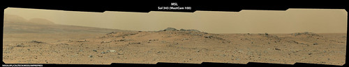
Full size: http://www.flickr.com/photos/84750994@N05/9369171019/sizes/o/
Edit: Re-uploaded. Fixed exposure settings and used my updated mask.
Posted by: Phil Stooke Jul 26 2013, 07:06 PM
Wow, that is nice! Oi'll give it Foive - as they used to say.
This is the 345 location - the rocky hilltop is not the one we seemed to be approaching yesterday but the next one to its southwest.
Phil

|
Posted by: EdTruthan Jul 26 2013, 08:27 PM
Sol 345 Navcam Anaglyph - 5 frames this time....
http://www.edtruthan.com/mars/Sol345-5-Frame-Navcam-Anaglyph.jpg
...and a Sol 344 four frame MC 34 panorama.
http://www.edtruthan.com/mars/Sol344-MC34-4-Frame-Panorama.jpg
Posted by: Phil Stooke Jul 26 2013, 11:47 PM
I borrowed Edtruthan's nice pan from 344, did a vertical stretch and compared it with a map of the landing ellipse. I think the ridge on the horizon is the rim of that crater just west of the ellipse. There's another small crater rim in the middle distance as well.
Phil

|
Posted by: iMPREPREX Jul 27 2013, 12:52 AM
Here's my take on 344's MastCam 34 mosaic. I'm messing with masks trying to get rid of the rough edges and corners of the images where they vignette: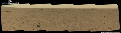
Full size: http://www.flickr.com/photos/84750994@N05/9374857654/sizes/o/
Posted by: Gerald Jul 27 2013, 10:42 AM
http://mars.jpl.nasa.gov/msl-raw-images/msss/00344/mrdi/0344MD0069000000E1_DXXX.jpg decoated:
http://imgbox.com/adejvfMf
Posted by: PaulH51 Jul 27 2013, 11:26 AM
Huge improvement, thanks Gerald. Now we can enjoy MARDI again.
Posted by: Actionman Jul 27 2013, 11:45 AM
Sol 344 MARDI decoated:
pebbly 
Posted by: iMPREPREX Jul 27 2013, 08:57 PM
WOW, Zelenyikot. That's perfect.
And those MARDI's are looking awesome, guys.Sol 345, MastCam 100. It's really starting to get exciting - especially when I look at the map and see how much distance the rover is clearing every day.
http://www.flickr.com/photos/84750994@N05/9380486722/sizes/o/
Posted by: Explorer1 Jul 28 2013, 12:18 AM
Strange shape to that rock in the bottom right, almost looks like its disintegrating.
Or is it an illusion due to the angle with two rocks blending together?
Posted by: wildespace Jul 28 2013, 10:37 AM

|
Having noted this interesting "double rock" feature on the horizon, I decided to make a time-lapse of the Mastcam images from sols 342-345, focused on that feature. Here it is: http://www.pictureshack.us/images/96531_0zGXh51375006556.gif
P.S. I think I located this rock formation in the latest HiRISE image:

|
Posted by: Actionman Jul 28 2013, 11:32 AM
http://mars.jpl.nasa.gov/msl-raw-images/proj/msl/redops/ods/surface/sol/00346/opgs/edr/ccam/CR0_428207435EDR_F0100288CCAM09346M_.JPG
Pebblyer
Posted by: Phil Stooke Jul 28 2013, 07:38 PM
We just had a drive on sol 347. Only a few thumbnails down so far, and I have a possible location about 40 m WNW of our last stop, but really need proper images before I can be sure. - EDIT - no, it was SW. Well, they were only thumbnails!
Phil
Posted by: centsworth_II Jul 28 2013, 09:15 PM
*Although what kind of a penetrator uses a parachute?

Posted by: Gerald Jul 28 2013, 09:33 PM
Sol 347 Navcam Stereo, near the end of the drive or post-drive:
http://imgbox.com/acrzDMwt
Interesting shape of the large pebble in the foreground.
Posted by: nprev Jul 28 2013, 09:45 PM
Yeah, given a couple billion or more years of wind interesting shapes get carved.
I find it interesting that some of the odd rocks on other worlds in the old SF movies & TV series were fairly close to what we're actually seeing on Mars on a smaller scale.
Posted by: RRussman Jul 28 2013, 10:12 PM
Here is a 1400m by 700m extent of the full route, back shell, chute, and descent stage, with an elevation profile extending from the sol 345 position to the back shell.

|
Posted by: Phil Stooke Jul 28 2013, 11:21 PM
Nice map! Here's the new location - proper map update on Monday.
Phil

|
Posted by: EdTruthan Jul 29 2013, 12:22 AM
Sol 347 Anaglyphs... Check out the rock the left wheels came over in the rear hazcam view. Almost looks as if the wheels dug in behind it a bit during the push....
Hazcam Front:
http://www.edtruthan.com/mars/Sol347-Front-Hazcam-Anaglyph.jpg
Hazcam Rear:
http://www.edtruthan.com/mars/Sol347-Rear-Hazcam-Anaglyph.jpg
...and a 360 degree Navcam 12-frame horizonal anaglyph:
http://www.edtruthan.com/mars/Sol347-360-Degree-Navcam-Panorama-Anaglyph.jpg
...and a 2-D (full frames) view:
http://www.edtruthan.com/mars/Sol347-360-Degree-Navcam-Panorama.jpg
Edit 1 : 2 more frames from the Sol 347 Navcam panorama came in and were added to the right side. The right side view is really fetching with the crater rim off in the distance, especially in 3-D.
Edit 2: Additional 3 frames to the Sol 347 Navcam panorama to complete a 360 degree view.
Posted by: Gerald Jul 29 2013, 12:47 AM
Crossed-eyes stereo of the dark-toned boulders, Sol 347 Navcam B:
http://imgbox.com/abcmcK8z
Posted by: fredk Jul 29 2013, 02:01 AM
And now we're practically sitting on top of it:
http://mars.jpl.nasa.gov/msl-raw-images/proj/msl/redops/ods/surface/sol/00347/opgs/edr/ncam/NLB_428304609EDR_F0100508NCAM05114M_.JPG
Posted by: RRussman Jul 29 2013, 03:24 AM
Below is a 3d surface render (3x exaggeration) looking ESE from the backshell and chute towards MSL's Sol 345 position. I could do a viewshed to find the best vantage point for MSL to image those features from but I'm pretty sure at the rate Curiosity is moving she will beat me there.

|
Posted by: James Sorenson Jul 29 2013, 05:20 AM
If they could extend the arm all the way above the mast, would that allow possible imaging of the Back-shell and parachute from our current vantage point with MAHLI?
Posted by: Explorer1 Jul 29 2013, 05:31 AM
The hazard outweighs the reward, IMO. Simpler to just drive closer; the backshell and chute don't have nasty fuel contaminants to warrant such caution, like the skycrane.
Posted by: James Sorenson Jul 29 2013, 05:59 AM
How is extending the arm above the height of the mast a hazard? With fabric, possible contaminates from chared ablative material, and parachute cords getting caught in the wheels....Sounds like more of a risk just going over there...
http://msl-scicorner.jpl.nasa.gov/Instruments/MAHLI/
all the way at the bottom
"Examples of How MAHLI will be Used
MAHLI has a range of capabilities and presents considerable flexibility for use. Some ways the camera will be used include (but are not limited to):
"Periscope Imagingrobotic arm is extended upward to allow MAHLI to look over the top of something that the other cameras cannot reach (the robotic arm can place MAHLI higher above the ground than the top of the Remote Sensing Mast)."
Posted by: mcaplinger Jul 29 2013, 06:14 AM
This gets you about a meter higher, but MAHLI's resolution is only about 60% that of the 34mm Mastcam.
I'm not sure what useful information could be gotten from even close examination of the backshell.
Posted by: James Sorenson Jul 29 2013, 06:30 AM
Thank you Mike. I'm wondering if that extra meter would help resolve it over the various hills between us and the backshell/parachute. It would be interesting to try if it could.
Posted by: Phil Stooke Jul 30 2013, 01:29 AM
Now we have a full 360 navcam pan from 347, so here's a circular version showing our tracks running back into the distance.
Phil

|
Posted by: craigmcg Jul 30 2013, 10:22 AM
Is there any evidence that the parachute has moved significantly since it landed?
Posted by: iMPREPREX Jul 30 2013, 11:01 AM
We won't know until we see it - if we see it...
Sol 347 - MastCam 34. I love these 4 and 5 frame mosaics.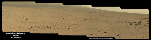
Full size: http://www.flickr.com/photos/84750994@N05/9400917770/sizes/o/
Posted by: vikingmars Jul 30 2013, 11:05 AM
Yes, you are right, if I may say : absolutely nothing to gain on a scientific point of view.
But, maybe, this would made a gorgeous view to be released for the public and the Press...
Definitely this picture is missing from our Mars exploration collection : no pics were taken from the ground of backshells and chutes from VL1, VL2, MPF, and PHX (just the backshell in this case). And just a (very) distant view was taken from Spirit and a quite-distant view from Opportunity...
I'm among the ones who favor this kind of outreach events, having oftenly to talk to friends of the Press in France about this exiting MSL mission.
Anyway, a good Mastcam 100 pic (with a nice perspective view on the distant Gale rim), will have a much better impact on the Press than the fuzzy distant pics taken by Spirit and Opportunity. Just remember the good press we had when Opportunity came close to its heatshield to have a good view at it... This human-made twisted structure was seen everywhere !
Posted by: Phil Stooke Jul 30 2013, 12:32 PM
"Is there any evidence that the parachute has moved significantly since it landed? "
The parachute has not moved, really, but it has flopped around a bit. HiRISE pics taken at different times show this clearly - the HiRISE folks released a GIF showing that a while ago:
http://photojournal.jpl.nasa.gov/catalog/PIA16813
I also posted the latest view higher up in this thread and if you compare it with the view just after landing (easy to find) you can see the change.
Phil
Posted by: PaulH51 Jul 30 2013, 02:30 PM
I can see there are some in favour of a visit to the backshell, and those who are not and prefer to move on.
I am one who is in favour of a close visual inspection (from a relatively safe distance). I also guess that the entire engineering team who had a hand in designing and manufacturing that piece of EDL hardware would like to see it as well. Let me try to put this into perspective. If the backshell and parachute designs were never going to be reused, then I would not be so enthusiastic, but from what I have been reading about the next NASA/JPL mission to Mars, the planners are considering the reuse of much of the MSL hardware in order to keep the budget 'affordable'. From the HiRISE images it appears that it did not break into a mass of pieces, so the odds are in favour of a chance of some feedback. What sort of feedback may we glean? Possible feedback includes: heat shielding effectiveness during entry and evidence of negative backwash effects of the lander's thrusters which were planned to be fired before backshell / lander separation. These and any other available visual feedback could provide invaluable data and boost the confidence levels in the effectiveness of that hardware and speed its subsequent approval for re-use.
In the end the decision has already been made by JPL for such a visit. We will see in the next few sols if that visit will be soon. If not now, maybe they will consider a visit after the trip to Mt Sharp
Posted by: mcaplinger Jul 30 2013, 02:51 PM
Examination of the heatshield might yield this (I say "might" because you can read the open literature (e.g., http://trs-new.jpl.nasa.gov/dspace/bitstream/2014/42204/1/11-2275.pdf ) and see if the engineering benefit from looking at the heatshield on MER was worth the resulting contamination of the rover) but little of that applies to the backshell.
That said, I have no idea what they are planning. I agree that there is some outreach potential but IMHO there are more attractive options.
Posted by: dvandorn Jul 30 2013, 03:25 PM
MSL is in a different situation than Oppy. It has a zoom setting on Mastcam, so some very good information can be acquired without approaching really closely to any EDL hardware. All we need is a good vantage point from which to image it.
In my humble opinion, I think a survey of the damage caused by the impact and breakup of the descent stage is more applicable to future MSL-like operations than a view of the backshell and 'chute. If we re-use the skycrane approach on the next rover (as seems likely), it will be useful to know whether or not we need to change the flyaway maneuver to get a greater distance from the rover's landing point to the descent stage crash site, for instance.
Obviously, though, any survey of the descent stage crash site must be done from a distance. Don't want to approach that mess too closely.
-the other Doug
Posted by: mcaplinger Jul 30 2013, 04:52 PM
Of course there's no zoom per se. The 100mm Mastcam has about 3x higher resolution than the MER Pancam. It depends on how close one gets as to how good those images could be. For example, the MER-B images were taken at a range of about 440m -- http://marsrovers.jpl.nasa.gov/gallery/press/opportunity/20040209a.html M100's would be 3x better.
I'm pretty sure that if there is a clear view along the route that they will try to take images. I don't know if there is any plan to tailor the route for this.
Posted by: EdTruthan Jul 30 2013, 05:31 PM
Both Sol 347 Navcam Panoramas in http://www.unmannedspaceflight.com/index.php?s=&showtopic=7691&view=findpost&p=202001 updated to full 360 degree views, this 5 panel section of which deserves its own full frames view in anaglyph...
http://www.edtruthan.com/mars/Sol347-5-Frame-Navcam-Crater-Rim-View-Anaglyph.jpg
Posted by: dvandorn Jul 30 2013, 06:05 PM
I'm pretty sure that if there is a clear view along the route that they will try to take images. I don't know if there is any plan to tailor the route for this.
Yep -- sorry about the poor phrasing in re Mastcam, I've been in and out of the hospital over the past couple of months and sometimes my word choices while on heavy-duty painkillers could stand a little improvement. Of course, I was referring to the availability of both the M34 and M100 modes of Mastcam.
As for imaging the EDL hardware, the only reason I mention it is that during the telecon where the general plan for the post-conjunction wrap-up and Mt. Sharp traverse were discussed, it was stated (and if IIRC was noted on one of the powerpoint slides) that one of the goals for the early portion of the long traverse was to find vantages from which EDL hardware could be imaged. I guess that's why I've been a little surprised that the traverse route seems to be heading well south of both the landing site and the EDL hardware that is roughly "on the way" as we head towards the mountain. But, hey -- priorities change.
Also referring back to that telecon -- wasn't there some discussion of revisiting Hottah and perhaps doing some more involved work on characterizing the matrix of that conglomerate unit? We're obviously not heading anywhere close to Hottah, which again surprised me a bit, I guess. Are the managers thinking we'll likely find other examples of the "Hottah unit" elsewhere along the traverse path? Or do they think that the same or similar units were adequately analyzed back at Yellowknife Bay and its environs?
-the other Doug
Posted by: acastillo Jul 30 2013, 07:02 PM
http://mars.jpl.nasa.gov/msl-raw-images/proj/msl/redops/ods/surface/sol/00347/opgs/edr/ncam/NLB_428304609EDR_F0100508NCAM05114M_.JPG
Visually, this is a particularly fascinating. 4 boulders nearly equally spaced around a little hill. I wonder if it could have been 1 large boulder that broke apart into the 4 large pieces that are slowly separating and migrating down slope.
Posted by: RoverDriver Jul 30 2013, 07:03 PM
I'm pretty sure that if there is a clear view along the route that they will try to take images. I don't know if there is any plan to tailor the route for this.
While I agree that the spatial resolution of the M100 is 3x better than the MER PANCAMs, the S/N ratio on all the MSSS cameras is considerably better. To my eyes the clarity, detail and information you can get from MAHLI, MARDi, M34, and M100 is quite amazing and I'm blown away every time.
Paolo
Posted by: Gerald Jul 30 2013, 09:55 PM
I've been considering a crushed secondary impact body, with smaller (dark-toned) fragments scattered around, as one of several options.
Posted by: acastillo Jul 30 2013, 10:28 PM
Gerald, that makes sense. In looking at some of the HIRISE images of the area, the boulders appears to be concentrated on these nobs and small rises. Could this be because the boulders are creating sand traps where wind-blown sediment is collecting?
Posted by: Phil Stooke Jul 30 2013, 10:44 PM
I prefer the idea of them being remnants of a layer of material which is mostly eroded away.
We just drove again, to the south. No position yet, I need full navcams for that.
Phil
Posted by: EdTruthan Jul 30 2013, 11:39 PM
...or even very high velocity first impact crater sites whose surrounding material has been eroded away by many eons of wind? Several of the rocky mounds in this area look somewhat rounded in appearance in the HIRISE images. So could the hillocks themselves, with their dark rocky boulders, simply be remnants of a once buried but highly compacted crater center, where the ground was super heated by the intense impact, leaving heavily compressed ground (the mounds) and dark rocky impact debris (the boulders) that have since resisted the erosional forces that subsequently removed all evidence of the once overlying craters themselves? Not sure how old they'd have to be for that much erosion to have occurred, but it's a thought anyway.
And yup, we're traveling again...Sol 349 Rear Hazcam Anaglyphs. Gives a clue as to the direction maybe.
http://www.edtruthan.com/mars/Sol349-Rear-Hazcam-Roving-1-Anaglyph.jpg
http://www.edtruthan.com/mars/Sol349-Rear-Hazcam-Roving-2-Anaglyph.jpg
Posted by: mhoward Jul 31 2013, 01:15 AM
Her drive direction is http://www.flickr.com/photos/marscat/9403161065/ now that the NAIF data has been updated. I'm a little surprised she left the dark boulder area so quickly! She really is all about driving these days! Well, looks like there was a were a couple ChemCam shots in passing, and I hope some Mastcam images still to show up.
Posted by: RRussman Jul 31 2013, 03:36 AM
It also seems that she is migrating from the http://hirise.lpl.arizona.edu/dtm/dtm.php?ID=PSP_010573_1755 onto the http://hirise.lpl.arizona.edu/dtm/dtm.php?ID=ESP_018854_1755. The latter aligns and flows nicely with the PSP_009650_1755 dtm. It looks like a mostly smooth surface from the current position to the Mount Sharp Base/Entry. Well, at 1m resolution it does anyway. I bet those looking at the navigation mesh products might disagree.
Posted by: Phil Stooke Jul 31 2013, 02:18 PM
Circular pan from sol 349 - a very interesting area we are passing through!
Phil
|
Posted by: acastillo Jul 31 2013, 02:56 PM
They certainly are putting the petal to the metal. It must be frustrating for the geologists on the science team to see all these beautiful land forms passing by, without taking the time to sample them. I know if would have stopped at each outcrop to chip a small sample and do a quick identification before moving on. But that's the difference between a robotic and organic geologist. It probably would have taken a human explorer a week to do what Curiosity has done in a year. Hey NASA, I'm volunteering. No luck.
Posted by: Phil Stooke Jul 31 2013, 03:38 PM
ChemCam has been sampling for them, in a sense. And the Navcam geomorphology and Mastcam high resolution imaging have a lot to tell us as well. They got a lot out of the conglomerates at Link and Hottah with just those tools. But I'm sure there will be occasional stops to do a bit more.
For those interested in such calendrical musings, today is the last sol of Mars Year 31, and tomorrow (starting about 19:00 hours this evening UTC) is the first sol of Mars Year 32, using the Clancy calendar which I adopted for my atlas. (This is a planetwide date, so presumably referring to time at the zero meridian, not local lander time anywhere else)
Phil
Posted by: EdTruthan Jul 31 2013, 04:18 PM
Sol 349 - 360 Degree Navcam Panoramas...
Horizonal Anaglyph:
http://www.edtruthan.com/mars/Sol349-Navcam-360-Degree-Panorama-Anaglyph.jpg
2-D Full Frame:
http://www.edtruthan.com/mars/Sol349-Navcam-360-Degree-Panorama.jpg
Posted by: iMPREPREX Aug 1 2013, 12:33 PM
Here's Sol 349 with a color corrected mosaic (oops - what Mcaplinger said. Arbitrarily white-balanced):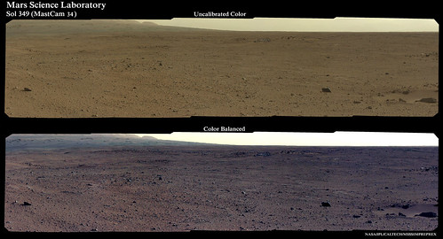
Full sized image: http://www.flickr.com/photos/84750994@N05/9413007457/sizes/o/
Posted by: mcaplinger Aug 1 2013, 02:46 PM
Rather than "color corrected" it would be more accurate to say "arbitrarily white-balanced."
Sorry, pet peeve of mine.
Posted by: Phil Stooke Aug 1 2013, 03:38 PM

|
Don't panic!
Phil
Posted by: acastillo Aug 1 2013, 04:02 PM
I guess that I am not alone. So many rocks. The next rover needs a rock hammer.
Posted by: Phil Stooke Aug 1 2013, 10:09 PM
A new drive... turning west again - a bit south of west onto some bright outcrops. More later...
Phil
Posted by: iMPREPREX Aug 2 2013, 12:34 AM
These guys just came down. Sol 324 (#1315):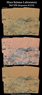
Full sized image: http://www.flickr.com/photos/84750994@N05/9417086279/sizes/o/
GigaPan: http://www.flickr.com/photos/84750994@N05/9417086279/sizes/o/
And edited to add this from Sol 331. Tracks!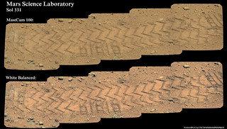
Full sized image: www.flickr.com/photos/84750994@N05/9420373142/sizes/o/
Cool.
Posted by: Phil Stooke Aug 2 2013, 02:37 AM
Here is the new location - proper map update tomorrow - and a circular pan from 351.
Phil
|
|
Posted by: James Sorenson Aug 2 2013, 02:37 AM
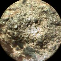
It's interesting that they didn't investigate this conglomerate rock on Sol-335.
http://mars.jpl.nasa.gov/msl-raw-images/msss/00335/mcam/0335MR1351000000E1_DXXX.jpg
Posted by: Phil Stooke Aug 2 2013, 02:49 AM
I think we'll be seeing conglomerate frequently along the way. We might stop for one later.
If MER is anything to go by, an interesting strategy to contemplate will be looking for really good science targets to examine over US holidays, particularly Thanksgiving and Christmas, but possibly others. In the days leading up to the break a target is identified and approached, and then a series of activities is programmed over the holiday, finishing up with some brief but intense contact science just after the break and before driving on. That would involve the least possible interruption to the drive but still allow good work for several sols.
Phil
Posted by: volcanopele Aug 2 2013, 03:57 AM
I agree with Phil, but still, I love that image. Provides in one close-up image a comparison between two very different rock types.
Posted by: iMPREPREX Aug 2 2013, 04:16 AM
Here's a collage of some stereo images:
Full resolution: http://www.flickr.com/photos/84750994@N05/9420809410/sizes/o/
GigaPan: http://www.gigapan.com/gigapans/136334
Posted by: djellison Aug 2 2013, 05:12 AM
I'm not sure one could consider things they don't do as interesting.
Apparent absence of observation doesn't mean absence of interest.
Posted by: iMPREPREX Aug 2 2013, 11:40 AM
Some nice shots just came in of Mount Sharp from sol 344, but we're still missing the top of the mountain. These also came in from Sol 344: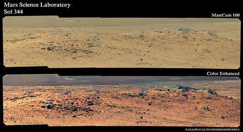
Full sized image: http://www.flickr.com/photos/84750994@N05/9419841681/sizes/o/
...Color enhanced"??
Posted by: wildespace Aug 2 2013, 11:40 AM
http://mars.jpl.nasa.gov/msl-raw-images/msss/00335/mcam/0335MR1351000000E1_DXXX.jpg
They examined both rocks with ChemCam: http://mars.jpl.nasa.gov/msl/multimedia/raw/?s=335&camera=CHEMCAM_
Would be nice to see them colourised, and learn of any data gleamed from this examination.
P.S. just stumbled across this amazing collection of ChemCam images: http://flickrhivemind.net/Tags/chemcam/Recent
Posted by: iMPREPREX Aug 2 2013, 12:47 PM
Wow, he has some awesome stuff! He does some serious black magic with those images!
Thanks for sharing that, WS.
And not to spoil the surprise, but here's what we have to look forward to from Sol 344:
Posted by: acastillo Aug 2 2013, 01:36 PM
Conglomerates are not great at preserving organics, so I bet they are not as interested in these. Plus this rock was loose and not part of an outcrop. I do hope they will stop at an outcrop of this rock at some time, but I wouldn't be surprised if they don't.
Posted by: Gerald Aug 2 2013, 03:10 PM
Sol 244 344, hidden in the haze: the crater rim:
http://makeagif.com/Z2PjGW
Processed by appropriate stretching and smoothing.
Posted by: EdTruthan Aug 2 2013, 04:46 PM
FYI Note: Major internet outages with right now (a.m. Aug. 2nd) with Endurance International Group (includes Bluehost my hosting company), so thumbnails from all my posts and downloadable files may be intermittent till they're back up. Millions of people appear to be affected. Grrrr.
Posted by: Phil Stooke Aug 2 2013, 08:10 PM
Gasp! A placename! Yes, the east end of that knobbly ridge seen on sol 343 is "Twin Cairns Island".
http://photojournal.jpl.nasa.gov/jpeg/PIA17083.jpg
and here are two more names:
http://www.jpl.nasa.gov/spaceimages/details.php?id=pia17082
Phil
Posted by: EdTruthan Aug 2 2013, 09:01 PM
Sol 351 - Navcam Panoramas...
Horizonal Anaglyph:
http://www.edtruthan.com/mars/Sol351-Navcam-11-Frame-Panorama-Anaglyph.jpg
360 Degree 2-D Full Frame:
http://www.edtruthan.com/mars/Sol351-Navcam-360-Degree-Panorama.jpg
...and a Sol 344 stereo view of what looks to be (based on the azimuth data and MSL's position at the time) a morning shot at "Twin Cairns Island" before the drive that day...
http://www.edtruthan.com/mars/Sol344-MC34-MC100-5-Frame-Knoll-Anaglyph.jpg
And yup it's nice to have a few names of some of the terrain features...
Posted by: Zelenyikot Aug 3 2013, 12:02 AM
Colored and white balanced.

|
|
|
Posted by: jmknapp Aug 3 2013, 01:24 AM
Curiosity is really picking up the pace. Here's a graph showing the distance traveled (meters) over the previous week (7 sols), from the start of the trek last month:

|
Posted by: blake Aug 3 2013, 02:54 AM
First stab at using Hugin for panoramas. Here is a Mastcam Left set from sol 351. Still need to figure out exposure and vignetting.
|
|
Posted by: iMPREPREX Aug 3 2013, 03:31 AM
Hugin is incredibly powerful, but has a steep learning curve. I can't get my head around it, so I take the easy way out (I use PTGui). If you get Hugin down, however, you will be able to move mountains.
My take: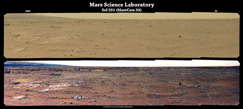
http://www.flickr.com/photos/84750994@N05/9424414841/sizes/o/
Posted by: Bubbinski Aug 3 2013, 01:17 PM
The pics from Curiosity make you feel like you're right there on Mars with her. Amazing shots of Phobos from the ground.
Sol 352 has come and gone but I don't see any raw images from that sol yet on the NASA site. Was she inactive? Or is it taking longer than usual to get the data processed?
Posted by: PaulH51 Aug 3 2013, 01:32 PM
Sol 352 has come and gone but I don't see any raw images from that sol yet on the NASA site. Was she inactive? Or is it taking longer than usual to get the data processed?
One possible reason for the lack of sol 352 images can be found in : Sol 350 Update On Curiosity From USGS Scientist Ken Herkenhoff: He reported that they were planning to test more of the Cumberland drill sample in SAM. This may have demanded a lot of the available power (depending on the actual tests scheduled)
Posted by: SFJCody Aug 3 2013, 06:11 PM
There's a good interview with Daniel Limonadi (senior flight systems engineer at JPL) on the latest http://www.thenakedscientists.com/HTML/podcasts/astronomy/show/20130710/. It's a few weeks old now but still worth a listen. MSL's current exploits and future plans are covered.
Posted by: Zelenyikot Aug 3 2013, 09:46 PM
Road to Mount Sharp. Sols 327-351
http://www.youtube.com/watch?v=yaabBVftGQs
Posted by: iMPREPREX Aug 4 2013, 02:22 AM
My take on Sol 344 with a color enhanced anaglyph. It really brings out detail. 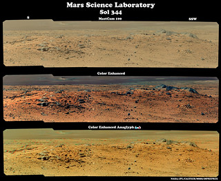
Full sized image: http://www.flickr.com/photos/84750994@N05/9430750149/sizes/o/
GigaPan: http://www.gigapan.com/gigapans/136484
Posted by: Greenish Aug 4 2013, 02:32 AM
Don't look now but... Massive 360-degree ML pan on sol 352! Top of Mt Sharp included. Thumbnails only at the moment but lots of them. (By the way mhoward, very grateful for Midnight Planets app right now.)
Posted by: Airbag Aug 4 2013, 03:58 PM
Sorry, had to take a peek :-) Quick preview using pointing data only:
[edit: fixed roll]

|
Airbag
Posted by: Phil Stooke Aug 5 2013, 12:19 PM
The only image from 354 so far is a thumbnail MAHLI. It shows tracks pointing back towards the east end of Mt Sharp, suggesting a turn to the NW. (just checking jmknapp's map shows this is the case) - so now I think we can say they are indeed heading to the parachute. The last stop was at a fork in the road, with two possible smoothish paths between patches of rough terrain. This particular smoother path zig-zags towards the parachute.
PS - jmknapp's route map has been corrected. It was drifting off the proper location but now it's been fixed.
Phil
Posted by: jmknapp Aug 5 2013, 12:33 PM
Good catch-I just did that this morning. I've been noticing a discrepancy between my map & yours for a while, and when NASA published the "official" track map a few days ago (matching yours) the time came to deal with it. I'm still not sure of what causes the divergence, whether a problem with the SPICE kernels, the registration of the HiRISE tiles, or maybe the map software, but for now I'm just using a periodic fudge factor to get things to line up. Hopefully it will require only occasional re-fudging on my part.
EDIT: might it be that the turn to the NW is to get around the rough terrain to the west? E.g., to proceed more or less like this?:
|
Posted by: PaulH51 Aug 5 2013, 12:48 PM
I do hope not
I still feel there are things to learn from a safe distance.....
Posted by: RoverDriver Aug 5 2013, 02:29 PM
EDIT: might it be that the turn to the NW is to get around the rough terrain to the west? E.g., to proceed more or less like this?:
...
That was the intent. The detour hopefully is only for a short while, but we'll see.
Paolo
Posted by: EdTruthan Aug 5 2013, 06:37 PM
Sol 354 - Quick first look at the new position surroundings (only 9 frames in). Nice dune line in the foreground...
Horizonal Anaglyph:
http://www.edtruthan.com/mars/Sol354-Navcam-360-Degree-Panorama-Anaglyph-V2.jpg
Full Frame 2-D:
http://www.edtruthan.com/mars/Sol354-Navcam-360-Degree-Panorama-V2.jpg
Edit: Remaining Nav frames came in. Updated to full 360 degree (i.e. 12 frame panoramas).
Edit 2: Applied a new anti-vignette routine to smooth out frame transitions while trying to keep the nearly over-exposed centers of frames in check. Still tweaking the process, but liking the results thus far.
Posted by: Phil Stooke Aug 5 2013, 06:53 PM
Very nice! Here is in a circular form. That drift makes it easy to see exactly where we are on jmknapp's map.
Phil

|
Posted by: Greenish Aug 5 2013, 08:35 PM
Regarding the plans for the EDL hardware and the route to Mt Sharp - The below is from the podcast (do listen to it though, it's quite good. I'm now a subscriber).
About 5:55 in Limonadi says the following:
Posted by: jmknapp Aug 5 2013, 09:41 PM
The NY Times website went live today with an interactive Curiosity tracker:
http://www.nytimes.com/interactive/science/space/mars-curiosity-rover-tracker.html?ref=space#
Nice clickable timeline with many panoramas created in-house by Times graphic editor Jonathan Corum, map by cartographer Jeremy White.
Posted by: RoverDriver Aug 5 2013, 11:37 PM
Yes but the map seems a bit off?
Paolo
Posted by: Phil Stooke Aug 5 2013, 11:41 PM
Yes, it is, probably for the same reason we have already discussed here. They are using uncorrected predicted positions.
Phil
Posted by: jmknapp Aug 5 2013, 11:50 PM
Paolo
I'm helping them with that--hopefully that will get closer soon.
Could you expand on that? The SPICE data is uncorrected predicted positions?
Posted by: Explorer1 Aug 6 2013, 12:01 AM
Ashwin Vasavda said in today's https://www.youtube.com/watch?v=tpmB4It0kn0 that they're not planning to drive close the chute and backshell, but didn't rule out distant imaging. Given the hilly terrain here, it's not guaranteed to even get that. He did say that the EDL team already knows what they need to know for the 2020 rover.
Posted by: Phil Stooke Aug 6 2013, 12:07 AM
This is what Paolo said in the Route Map thread, replying to a question:
"Hi Joe, your Drive Log shows 104.96 meters drive on sol 340 while JPL is reporting only 100,3 meters.
Can you explain possible root cause of this discrepancy?
Thx
One of the odometers on MSL FSW takes into account turn in place as motion while the one reported does not. The former also does not include VO corrections and allows to better assess actuator usage while the second tells you more how far the vehicle has moved.
Paolo"
The VO (Visual Odometry) corrections are taking wheel slip etc. into account, but reported values do not. Over time the slip errors, and distances recorded during turns in place etc. add up to create ever-larger errors in reported distances. Ultimately, only fixing positions by identifying features on the ground (like the lovely drift in front of us) will give precise results.
Phil
Posted by: Phil Stooke Aug 6 2013, 12:24 AM
The quote above about seeing descent stage fragments reminded me that one is to be found a bit west of the parachute:

|
I think this is the only debris that is this far south. If they do indeed try to look at it... but now it sounds like they may not bother with it.
Phil
Posted by: jmknapp Aug 6 2013, 12:32 AM
Ah, missed that one. So I guess the SPICE kernels are auto-generated from the wheel encoders.
That would explain why the discrepancies seem non-linear--like the landing site and Rocknest lined up well, but on the current trek is diverging. Hopefully a correction applied every so often (and interpolated in between) will keep it pretty close.
Posted by: djellison Aug 6 2013, 12:48 AM
Yup - Bundle Adjustment is a tricky problem.
Posted by: iMPREPREX Aug 6 2013, 01:37 AM
Beautiful. 
http://www.flickr.com/photos/84750994@N05/9448916736/sizes/o/
Happy 1 year anniversary!
Edit to add: I think I've nailed this 343 anaglyph. I've also level enhanced it:
http://www.flickr.com/photos/84750994@N05/9446290275/sizes/o/
Posted by: EdTruthan Aug 6 2013, 03:28 AM
Quick Note: Have updated the Anaglyph and 2-D panoramas from http://www.unmannedspaceflight.com/index.php?s=&showtopic=7691&view=findpost&p=202189 to full frame, 360 degrees panos (final 3 Nav frames came in). One Earth Year on Mars. Happy Anniversary to all. Come to think of it, I still have the whole landing night from JPL on the DVR... what a nail biter. Just might have to watch that again tonight. Still gives me goosebumps.
Posted by: EdTruthan Aug 7 2013, 03:26 AM
Sol 356 - Crossing the dune ripple...
http://www.edtruthan.com/mars/Sol356-Navcam-Dune-Traverse.jpg
http://www.edtruthan.com/mars/Sol356-Navcam-Dune-Traverse-Anaglyph.jpg
Posted by: iMPREPREX Aug 7 2013, 03:41 AM
My take on Sol 345 - sequence #1400: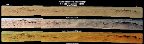
Image: http://www.flickr.com/photos/84750994@N05/9456750804/sizes/o/
GigaPan: http://www.gigapan.com/gigapans/136725
You can just make out little 3D dunes all the way by Mount Sharp!
Posted by: walfy Aug 7 2013, 03:47 AM
A quick movie from sol 356, showing the sharp turn before heading over the dune. sol356.mov ( 489.93K )
: 541
sol356.mov ( 489.93K )
: 541
Posted by: Gerald Aug 7 2013, 09:15 AM
Sol 356 MAHLI, rotated 150 degrees, white balanced (lower part of sky as reference). darkened, saturation enhanced:
http://imgbox.com/abcrlZ3B
Posted by: iMPREPREX Aug 7 2013, 09:30 AM
Nice rover tracks.
...And here's Sol 346. What awesome topography and some cool looking rocks! I can never get bored looking at rocks on Mars. 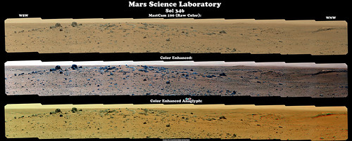
Image: http://www.flickr.com/photos/84750994@N05/9458119840/sizes/o/
GigaPan: http://www.gigapan.com/gigapans/136739
Edit: Also some cool rocks from 349 before I go to sleep (finally) - a collage: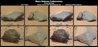
Image: http://www.flickr.com/photos/84750994@N05/9458384672/sizes/o/
Posted by: jmknapp Aug 7 2013, 10:49 AM
Basalt?

|
Posted by: PaulH51 Aug 7 2013, 12:03 PM
Not sure what it is made of, but it sure is a nice looking rock
Posted by: jmknapp Aug 7 2013, 02:33 PM
The blasted heath:

|
...from sol 349.
It's a mine field out there.
Posted by: RoverDriver Aug 7 2013, 03:07 PM
This quote should be included in all future editions of "What to expect when you are expecting" ;-)
Paolo
Posted by: Phil Stooke Aug 7 2013, 03:42 PM
Good one! Here's a circular version of the navcam pan of our current location.
Phil

|
Posted by: EdTruthan Aug 7 2013, 06:41 PM
Sol 356 - Navcam 360 Horizonals...
One frame from the left series had a corrupted patch but not a real biggie. Damia's (Ant103) well blended 2-D versions are still superior to mine but until http://www.unmannedspaceflight.com/index.php?s=&showtopic=7691&view=findpost&p=201930 or posting again, I figured I'd knock them out as they come in. Have been trying some vignette reduction routines, but still tweaking it...
Anaglyph:
http://www.edtruthan.com/mars/Sol356-Navcam-360-Degree-Panorama-Anaglyph.jpg
2-D (right side):
http://www.edtruthan.com/mars/Sol356-Navcam-360-Degree-Panorama.jpg
Posted by: Phil Stooke Aug 7 2013, 07:43 PM
iMPREPREX posted the sol 346 Mastcam pan recently. If you can tear your eyes away from all the good stuff in the foreground, take a look at the landscape beyond the big rocks of Elsie Moluntain. A distant scarp appears, several km away, with a very flat top and a talus slope below it. Here I show where I think it must be, and probably where two points on the scarp are. I'm still refining the position but I think that's where it must be.
Phil

|
Posted by: Reed Aug 7 2013, 08:36 PM
Night sky imaging practice for upcoming comet observations perhaps?
Also a lot of different looking rocks in recent sols. This one from sol 351 looks like a big chunk of conglomerate to my non-geologist eye
http://mars.jpl.nasa.gov/msl-raw-images/msss/00351/mcam/0351MR1428000000E2_DXXX.jpg
Posted by: elakdawalla Aug 7 2013, 08:38 PM
If it looks like broken concrete, it's a conglomerate I'd say you're right.
Posted by: Actionman Aug 7 2013, 08:49 PM
The enigmatic color looks like it maybe part of the reflection of the sky off an enigmatic clear varnish like coating on the surface of this bolder.
Posted by: djellison Aug 7 2013, 09:01 PM
Really nothing enigmatic about a dust-blasted polished basalt. We've seen thousands of them over the years with various vehicles.
Posted by: jmknapp Aug 7 2013, 11:46 PM
Got an email notice that MSNBC's Alan Boyle's show Virtually Speaking Science starting in about 15 minutes (8pm EDT) will be about Curiosity:
http://www.blogtalkradio.com/virtually-speaking-science/2013/08/08/alan-boyle-yr-1-curiosity-on-mars
Posted by: Actionman Aug 7 2013, 11:47 PM
Rock identified as basalt compared with the recently posted high gloss bolder on the right.
Color adjusted contrast extended some.
Color wise the gloss bolder could be basalt but the color is some what grayer and could match some of the mud stone or the mud stone may have a shade or two different color down here nearer the mountain.

|
Posted by: jmknapp Aug 8 2013, 09:13 AM
For anyone following @curiositylog and excited about the reported https://twitter.com/CuriosityLog on sol 356, it looks like there's a glitch in the SPICE data files. Here are the last few records of the track sampled every 100 seconds:
{"sol":356,"utc":"2013-08-06T22:21:14Z","lmst":"01:16:14 P.M.","et":429099741,"longitude":137.436561,"latitude":-4.597388,"altitude":-4442.33},
{"sol":356,"utc":"2013-08-06T22:24:34Z","lmst":"01:19:29 P.M.","et":429099941,"longitude":137.437050,"latitude":-4.597299,"altitude":-4442.04},
{"sol":356,"utc":"2013-08-06T22:26:14Z","lmst":"01:21:06 P.M.","et":429100041,"longitude":137.436561,"latitude":-4.597388,"altitude":-4442.33},
So the longitude jumps from 137.436561 to 137.437050 and back again at the end of the track.
I changed the code to filter out impossible rover speeds, so now the http://curiosityrover.com/tracking/drivelog.html is cleaner and the sol 356 distance is 50.82 meters.
Posted by: dilo Aug 8 2013, 11:36 AM
I changed the code to filter out impossible rover speeds, so now the http://curiosityrover.com/tracking/drivelog.html is cleaner and the sol 356 distance is 50.82 meters.
Well done, Joe... I just updated my odometry file/plots. I see you changed also drive numbers, suppressing previous #44 which was a 0-meters shift!
Posted by: paraisosdelsistemasolar Aug 8 2013, 03:02 PM
I was merging some of the Sol 352 ML frames and Aeolis Mons looks really beautiful
http://imgur.com/7c9VPOG
Posted by: jmknapp Aug 8 2013, 03:22 PM
Good work getting that detail out.
BTW, what is the deal with the MARDI shots on this trek? They've been taking a MARDI shot on every drive sol, always around the same time, about a half hour after sunset (~7pm).
Posted by: elakdawalla Aug 8 2013, 03:50 PM
The MARDI shots are a way to survey the diversity of the pebbles on the ground. The straight-down view makes it easy to get precise measurements on their sizes and shapes. Jim Garvin is doing this work; http://www.lpi.usra.edu/meetings/lpsc2013/pdf/2493.pdf.
Posted by: James Sorenson Aug 8 2013, 06:06 PM
My take on the Sol-352 M34 Pan sofar.
http://www.flickr.com/photos/43581439@N08/9467659818/
Posted by: wildespace Aug 8 2013, 06:07 PM
BTW, what is the deal with the MARDI shots on this trek? They've been taking a MARDI shot on every drive sol, always around the same time, about a half hour after sunset (~7pm).
Related update from Ken http://astrogeology.usgs.gov/news?p=2&id=news/sol-329-update-on-curiosity-from-usgs-scientist-ken-herkenhoff-twilight-wins
Posted by: fredk Aug 8 2013, 06:37 PM
It's fascinating how a patch of the mountainside appears to disappear (arrowed) at certain times of day, when the lighting is just right:
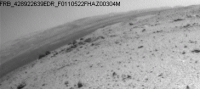
|
I guess with just the right angle of illumination, the surface brightness of that patch matches almost perfectly the surface brightness of the adjacent sky (at least integrated over the hazcam spectral response), so it looks as if we're seeing through a "gap" in the mountainside. It reminds me of some kind of atmospheric "mirage" effect, though I'd guess that's unlikely with the low air density on Mars.
Here are the original frames:
http://mars.jpl.nasa.gov/msl-raw-images/proj/msl/redops/ods/surface/sol/00354/opgs/edr/fcam/FRB_428922639EDR_F0110522FHAZ00304M_.JPG
http://mars.jpl.nasa.gov/msl-raw-images/proj/msl/redops/ods/surface/sol/00355/opgs/edr/fcam/FRB_429000867EDR_F0110522FHAZ00323M_.JPG
And another one which shows the "mirage" on a different sol, presumably near the same local time:
http://mars.jpl.nasa.gov/msl-raw-images/proj/msl/redops/ods/surface/sol/00351/opgs/edr/fcam/FRB_428645770EDR_F0110000FHAZ00323M_.JPG
I haven't been able to find navcam or mastcam imagery showing the "mirage", but I'd love to see some...
Posted by: walfy Aug 8 2013, 07:59 PM
That is very weird, and the same part of the mountain, too, in those two images in which it appears. On the "flicker-GIF," were the two images taken nearly around the same time?
Posted by: djellison Aug 8 2013, 08:05 PM
Clearly not - just look at the shadows in the imagery - Fred has give you links to it.
Posted by: jmknapp Aug 8 2013, 08:36 PM
Thanks, Emily & wildespace, that really explains what they are doing with the MARDI shots. Who knew that Mars pebble size follows a log-hyperbolic distribution?
Per the abstract, Dr. Garvin found the preliminary data to be most consistent with volcanic ejecta.
Posted by: iMPREPREX Aug 8 2013, 10:52 PM
My take on 356:
http://www.flickr.com/photos/84750994@N05/9469269592/sizes/o/
Posted by: atomoid Aug 8 2013, 10:52 PM
Didn't expect the hazcam compression to average-away the ridge quite like that, but i do remember seeing many instances of disappearing horizons in the MER data sort of like this but much worse (some even had jagged serrations at the clipping point). perhaps they have improved those algorithms but this is still an an edge case exploiting a sweet-spot, http://www-robotics.jpl.nasa.gov/publications/Mark_Maimone/fulltext.pdf..
Posted by: fredk Aug 9 2013, 12:45 AM
We've definitely seen examples with MER where the sky is overexposed and it "bleeds" across the horizon because of how the CCD works. But that's not what we're seeing here - the sky is nowhere near overexposed. I think the mountainside in that direction really does happen to match the brightness of the sky fairly closely, at the right time of day. But navcams or mastcams would settle it.
PS - haven't noticed this sort of white layer since back around Yellowknife Bay:
http://mars.jpl.nasa.gov/msl-raw-images/msss/00352/mcam/0352ML1438074000E1_DXXX.jpg
Posted by: Deimos Aug 9 2013, 02:00 AM
I recall some Phoenix albedo pans where the terrain blended into the sky without a horizon line, due to a radiance match. That's not possible with the color cameras, or in color pans in general, due to the sky being bluer. But that's not as funky as this.
Posted by: iMPREPREX Aug 9 2013, 06:27 AM
From Sol 345:
Image: http://www.flickr.com/photos/84750994@N05/9468462375/sizes/o/
GigaPan: http://www.gigapan.com/gigapans/136891
And here's a nice cropped and processed shot if anyone is interested. 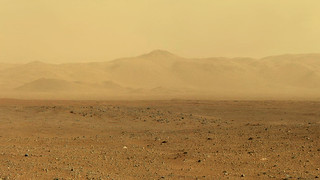
http://farm3.staticflickr.com/2807/9468600055_a5a4c98f4e_o.jpg
Posted by: Phil Stooke Aug 9 2013, 12:14 PM
The latest pics show a turn to the south, ending up sitting on one of the rocky hilltops. The view out to the southwest is really opening up now, should be spectacular in Mastcam. I'm on the road, and will update the map tonight or tomorrow.
Phil
Posted by: jmknapp Aug 10 2013, 12:44 AM
Anaglyph of big rocks from sol 349:

|
Posted by: Bubbinski Aug 10 2013, 02:15 AM
That big rock looks like Darth Vader's helmet buried in sand.
Thanks for the pic! That's what I keep coming here for.
Posted by: Phil Stooke Aug 10 2013, 04:29 AM
A rough circular pan from the 358 location. Hmmm, I wonder if this outcrop has a name?
Phil

|
Posted by: Ant103 Aug 10 2013, 02:35 PM
Hey everybody,
I'm back since 3 days from my little holidays. I missed a lot of thing I see Like Phobos transiting over Deimos  This is pretty amazing !
I had to take some days in order to process a lot of panoramics. I will not post Navcams panoramas. At least just the lasts one.
Mastcam34 was pretty busy as I've seen here
My takes on this mosaics :
Sol 344
http://www.db-prods.net/marsroversimages/curiosity-2013.html#91
Sol 345
http://www.db-prods.net/marsroversimages/curiosity-2013.html#94
Sol 351
http://www.db-prods.net/marsroversimages/curiosity-2013.html#97
Sol 354 Navcam panorama :
http://www.db-prods.net/marsroversimages/Curiosity/2013/Sol354_pano.jpg
And Sol 356
http://www.db-prods.net/marsroversimages/Curiosity/2013/Sol356_pano.jpg
Oh, and HAPPY FIRST YEAR on Mars Curiosity
So now, time to do some Opportunity imagery…
Edit : Panoramics from Sol 358
http://www.db-prods.net/marsroversimages/Curiosity/2013/Sol358_pano.jpg
http://www.db-prods.net/marsroversimages/Curiosity/2013/Sol358_Mastcam34.jpg
And I will be done for today
Posted by: RRussman Aug 10 2013, 07:36 PM
A post 1 earth year anniversary map for perspective. There is quite a bit of information included. Hopefully some may find it useful. Route and distance features resolve nicely in the original image. http://www.flickr.com/photos/marsmojojojo/sets/72157635009972721/ are two more versions without the symbolized elevation and distance detail.

|
Posted by: Ant103 Aug 11 2013, 01:03 PM
Thank you Gerald
I had to do this since I've seen the output file of the panorama.
So, a Postcard of the Sol 351 Mastcam34 panorama
http://skyrings.deviantart.com/art/Gale-Crater-by-Curiosity-The-Road-to-Mount-Sharp-392404850
Note : this is hosted at my DeviantArt acount because my blog is in a state of freeze (limitation of my database on MySQL. I'm working on this issue).
Posted by: Floyd Aug 11 2013, 01:28 PM
Thank you for the map it is excellent. Is the red path an official proposed route?
Posted by: RRussman Aug 11 2013, 02:03 PM
Hello Floyd I am glad you like the map. The least cost path (red) route is not an official proposed, or even suggested, route. It just provides an alternative estimate for distance rather than a straight line between points. The cost path tool calculates a route between features based on the "least cost" to travel from pixel to pixel. In this case the cost is based on slope angles but can incorporate any number of variables. I would add that I am seeing some discrepancies in elevation values between adjacent (overlapping) DTM's and up to 50 meters difference between the DTM and unofficial SPICE data elevation values. However, the natural break classification scheme I use seem to align very nicely with the surface features in the ortho images.
Posted by: dilo Aug 11 2013, 04:55 PM
And I will be done for today
Damia, your work is fantastic, as usual!
Posted by: iMPREPREX Aug 11 2013, 06:58 PM
Good to see you back, Damia.
I don't even want to get into this one... I'll just say that it's mostly Sol 344 with about 4 images borrowed from 352 (part of Mount Sharp wasn't imaged in the 344 mosaic).
Then I thought it would be a great idea to add some sky. A fail - but I just couldn't throw away hours of work... It's all a learning process as I've learned how to use a few more tools in PhotoShop (obviously still need practice). Anyways...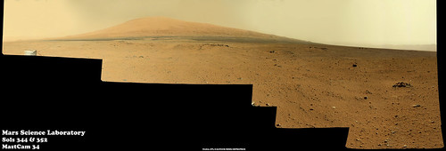
Image: http://www.flickr.com/photos/84750994@N05/9486407247/sizes/o/
GigaPan: http://www.gigapan.com/gigapans/137044
Edit: The sky is so bad. It was a valiant effort, though...
Posted by: jmknapp Aug 11 2013, 07:44 PM
A couple more anaglyphs from the current position:

|

|
Posted by: iMPREPREX Aug 11 2013, 08:01 PM
Two more sols - 356 and 358, respectively: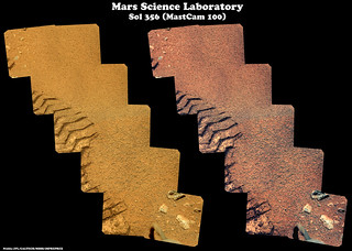
Image: http://www.flickr.com/photos/84750994@N05/9489694094/sizes/o/
GigaPan: http://www.gigapan.com/gigapans/137049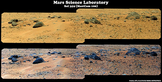
Image: http://www.flickr.com/photos/84750994@N05/9489486548/sizes/o/
Posted by: Phil Stooke Aug 11 2013, 08:20 PM
Damia's great 358 pan in circular format.
Phil

|
Posted by: James Sorenson Aug 11 2013, 11:45 PM
Here is a medium size preview of the Sol 352 Panorama. That single dreaded image is whats keeping me from uploading the final.
http://www.flickr.com/photos/43581439@N08/9491198858/
Polar/LittlePlanet projection
http://www.flickr.com/photos/43581439@N08/9488548773/
EDIT:
Sol-344
http://www.flickr.com/photos/43581439@N08/9490364914/
Sol-345 Morning pan
http://www.flickr.com/photos/43581439@N08/9491770894/
Posted by: Gerald Aug 12 2013, 08:40 AM
Sol 361, post-drive MAHLI, just rotated 150 degrees:
http://imgbox.com/abxRMgYf
Posted by: Ant103 Aug 12 2013, 09:57 AM
Sol 361 Navcam pan :
http://www.db-prods.net/marsroversimages/Curiosity/2013/Sol361_pano.jpg
Posted by: Actionman Aug 12 2013, 11:47 AM
The dark dune does indeed look to be in the lowest elevation, I call this one; Acheron.
The opposite bank looks very steep!
Posted by: Gerald Aug 12 2013, 12:02 PM
Sol 360/361 FLB sequence consisting of APXS, MAHLI, APXS (overnight), new location: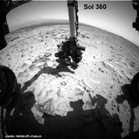
http://makeagif.com/YpqrTX.
Posted by: Phil Stooke Aug 12 2013, 01:39 PM
This is Damia's new Navcam pan in circular form. There's a relatively fresh impact crater a few drive distances ahead to the south, a possible target as it might excavate something from under this current surface.
Phil
|
Posted by: Gerald Aug 12 2013, 02:09 PM
Sol 360 MAHLI stereo as cross-eye
http://imgbox.com/adfm0taO
and as http://makeagif.com/rNfJbH.
Images are rotated 43 degrees to get displacement (almost) horizontal.
Edit: A little cross-eye stereo from two Sol 361 Navcam Right B traverse images (not the usual left/right stereo) :
|
To be complete, a second edit: Sol 360 Mastcam Right APXS mark enhancement (close to the center of the image) :
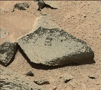
http://makeagif.com/mtSl78.
It was obtained by a series of appropriate white balancing, color stretching, channel splitting and combining operations.
Posted by: marsophile Aug 12 2013, 04:25 PM
The apparent gulch containing the dark dunes: is that the remains of a paleo-river or stream? Would that be an area of special interest, even if potentially hazardous?
Posted by: Phil Stooke Aug 12 2013, 04:41 PM
The area of greatest interest is in that valley, but of course not in a place where the dunes are covering the good stuff. It's a bit further to the southwest than we can easily see right now, but our view of it will improve over time. I'd say a lake was a better suggestion than a stream at that location. Streams flowed into this area from the north and southwest, but here we are more likely in an area of deposition, possibly in lakes.
Phil
Posted by: EdTruthan Aug 12 2013, 08:44 PM
SOL 361 - Navcam 360 Anaglyph. Some interesting terrain around here for sure. That circular formation a bit to the left of the UHF antenna is a rather curious feature...
http://www.edtruthan.com/mars/Sol361-Navcam-360-Degree-Panorama-Anaglyph.jpg
Posted by: Actionman Aug 12 2013, 11:35 PM
The dark dune could be stream bed silt made up of heavy grains of a variety of iron oxides complete with ripples.
Posted by: Phil Stooke Aug 13 2013, 12:07 AM
No. They are dark basaltic sand transported and sculpted by the wind.
Remember the Martian environment is very dry now. The water which flowed in those streams coming off the crater walls flowed long ago, maybe 3 billion years or more. If water ever flows now it will be in tiny amounts in some of the gullies we've seen elsewhere. Ripples could have formed in an ancient streambed, but they would have been eroded away in the intervening billions of years. If we see those things now, only the wind can have formed them. And these features have been observed to move from year to year in HiRISE images. We know they are active right now.
Also - if a stream, where did it flow from, and where to? The geography doesn't support it.
There's lots of information on Gale crater out there (check the FAQs in the MSL section) - check it out.
Phil
Posted by: serpens Aug 13 2013, 01:44 AM
Too true. We don't have much of a clue as to how much material was deposited over the existing surface and then eroded, but the inverted channels on the fan and elsewhere indicate that the current surface was beneath the level where those streams flowed. The current topography does not necessarily reflect the topography of that time. The thing that niggles is that the southern crater rim is almost eroded away, unlike the northern rim. One possible (though right out there) explanation given the huge difference in elevation is that the northern rim was actually submerged and thus protected during the high energy aeolian environments of the Noachian and early Hesperian.
Posted by: Actionman Aug 13 2013, 02:17 AM
It was obtained by a series of appropriate white balancing, color stretching, channel splitting and combining operations.
Now that looks like granite.
Posted by: dvandorn Aug 13 2013, 03:16 AM
I'm not sure how likely it would be to find granitic rocks on Mars -- my understanding is that most all terrestrial granites are a product of plate tectonics, formed by the interaction of the water in subducted sea floor materials interacting with the hot crust/mantle interface and enriching the basaltic mantle with the quartz and aluminous feldspathic grains found in granites. The theory I heard was that this melt would be significantly lighter than the basaltic mantle and would push up through cracks in the crust to form a granitic "basement" to the continental landmasses below which the sea floor is being subducted. (Of course, when I try to look up information about this theory, Wikipedia seems to think it's an outdated opinion and not in vogue these days...)
Now, if significant granite *were* to be found anywhere on Mars, it would be interesting to speculate on the process of its formation.
-the other Doug
Posted by: elakdawalla Aug 13 2013, 03:51 AM
No. It is not granite. It is almost certainly a Mars basalt, on which the contrast has been turned up to 11 to make it look bright. Granites happen on Earth because the rocks have been partially melted and recycled and partially melted and recycled a million times. They are refined through huge amounts of geologic processing. Nobody expects to find them on Mars. Maybe Venus (where there are dome volcanoes that could mean silica-rich granite-like melts) but not Mars.
http://www.planetary.org/blogs/emily-lakdawalla/2012/10120819-curiosity-sol65-petrology-jake.html The petrologists were super excited that they had found a basalt that was marginally more evolved than the basalts that have been found everywhere else on Mars. It was still basalt. If anybody even finds an andesite, the petrologists will be over the Moon. Granites/rhyolites are really not at all likely.
And nobody can identify a rock's specific composition from a Mastcam photo. You need something that can tell you elemental and/or mineralogical makeup: APXS, ChemCam, or Chemin. If it's a dark-colored rock and you call it "basalt," you'll be right most of the time; and if you're saying it's not basalt you'll need analytical instrumental results to back up that extraordinary claim.
Posted by: James Sorenson Aug 13 2013, 04:00 AM
The Finished Sol-352 Full Resolution Panorama.
http://www.flickr.com/photos/43581439@N08/9499896514/
http://www.flickr.com/photos/43581439@N08/9500438582/
Posted by: jmknapp Aug 13 2013, 11:32 AM
Last week Ken Herkenhoff said this on his http://astrogeology.usgs.gov/news?id=news/sol-356-update-on-curiosity-from-usgs-scientist-ken-herkenhoff-first-earth-year:
What does that mean, exactly? Possibly MRO-related?
Posted by: pospa Aug 13 2013, 11:54 AM
What does that mean, exactly? Possibly MRO-related?
My understanding is that now the driver's team works in day shift pattern only, Mon-Fri. And there isn't enough time for next sol activity plannig&testing procedure between data download and instructions upload communication windows.
But why they cannot plan for at least every second sol is a bit puzzling for me.
Posted by: Tesheiner Aug 13 2013, 12:58 PM
AFAIK no one made that statement.
Edit: 'Planning is "restricted" this week' should be read as 'Working on "restricted sols" this week'.
Posted by: iMPREPREX Aug 13 2013, 01:00 PM
Argh, I know - another 352...
I've just worked so hard on this I have to post it. Finally got the sky much better thanks to James Sorenson's help.
James' and Damia's are still incredible. The only things I can offer in mine are compass points, enhanced color, a GigaPan, and a 360cities version that doesn't wrap around, hehe. 
Full sized image: http://www.flickr.com/photos/84750994@N05/9502537354/sizes/o/
GigaPan: http://www.gigapan.com/gigapans/137229
360cities: https://www.360cities.net/image/sol352
Posted by: MahFL Aug 13 2013, 01:16 PM
Remember, MSL is on battery power, the batteries are recharged by the MMRTG, so you can't operate anyway 24/7 with fully charged batteries. Also no driving during the Mars nighttime which of course could be Earths day time, depending on the synchronization of both planets. So sometimes it's "2 days" between drives, e.g.
Also they have a budget to adhere to ( so they can't just have a whole spare team ready to occasionally take over ), and are in this for the long term.
Posted by: Phil Stooke Aug 13 2013, 01:45 PM
"Restricted Sols" has a very specific meaning - on a good sol, like around sol 343, Curiosity could drive and send back images which would arrive on Earth in time for the team to plan the next drive that day. Each day that situation repeats so you get daily drives. But Mars sols are longer than Earth days and eventually get out of sync. Curiosity drives and sends back images, but they arrive too late for the planners to craft a new drive that day. So the second sol is used for imaging, ChemCam etc. and the next drive happens on the following sol. That's a restricted sol.
If you look at the Curiosity map, and the Opportunity map whenever long traverses are taking place, you will see alternating sequencers of daily drives and every other sol drives, as the rover passes into and out of restricted sols.
Doing drives strictly every other sol would require weekend work, so typically at the end of a week a 3-sol plan is made, usually including lots of imaging, ChemCam, plus a drive on one of the sols. This last weekend for the first time the 3 sol plan included arm operations (MAHLI, APXS) as well.
Phil
Posted by: jmknapp Aug 13 2013, 02:03 PM
That jibes with the http://astrogeology.usgs.gov/news?id=news/sol-359-update-on-curiosity-from-usgs-scientist-ken-herkenhoff-simple-plan:
10 PM PDT on that date was right around sunset LMST, the time I notice when SPICE updates usually come in. So does the flow go like send up instructions during the morning MRO pass and get results during the evening MRO pass? Sunrise on sol 359 was 10:32am PDT, and the morning MRO pass somewhat earlier.
Posted by: djellison Aug 13 2013, 02:12 PM
Commands usually go up Xband, straight to the rovers HGA, not via MRO.
Posted by: elakdawalla Aug 13 2013, 02:23 PM
And just in case it wasn't clear from Phil's post, they plan one sol every day, it's just that without end-of-drive information they can't plan a drive (or, for that matter, arm movements) every day. Unlike Opportunity they don't have "touch-and-go" capability, at least not yet. Also note that without the end-of-drive data they can't even do targeted imaging, because without the end-of-drive navcams they don't know where interesting rocks are to point at with Chemcam and Mastcam.
Posted by: jmknapp Aug 13 2013, 02:47 PM
As for normal working hours, Joy Crisp said this last Thursday on http://www.blogtalkradio.com/virtually-speaking-science/2013/08/08/alan-boyle-yr-1-curiosity-on-mars:
And what we're doing right now is telling the science team that they need to, when they do the three days planning, that they need to make one day a real easy day, one day a medium complexity day and they can choose one day to be kind of a more normal complexity type of day.
Posted by: RoverDriver Aug 13 2013, 02:51 PM
For example Sol 102 and 159 were T&G, I think?
Paolo
Posted by: acastillo Aug 13 2013, 03:26 PM
I've just worked so hard on this I have to post it. Finally got the sky much better thanks to James Sorenson's help.
James' and Damia's are still incredible. The only things I can offer in mine are compass points, enhanced color, a GigaPan, and a 360cities version that doesn't wrap around, hehe.
360cities: https://www.360cities.net/image/sol352
|
Villa de la Mina looks like an interesting place to visit. Can Curiosity make 117 kilometers?
Seriously, I guess 360citites is not geared to places off planet.
Posted by: marsophile Aug 13 2013, 04:21 PM
Is nighttime driving for Curiosity totally not feasible, or would it be possible occasionally under ideal circumstances where power and visibility are not an issue? Just curious.
Powered by Invision Power Board (http://www.invisionboard.com)
© Invision Power Services (http://www.invisionpower.com)